* Latest guidance keeps us dry into Wednesday, good chance of a cold rain Thursday (maybe half an inch of liquid) ending as a period of snow New Year's Eve (Friday). Latest guidance is hinting at some 2-5" amounts on the last day of 2010 - best chance of 4 or 5" far western suburbs. Some 6-12" amounts are possible far northern/western MN late in the week - stay tuned for more updates as we get closer to the storm.
Paul's Conservation Minnesota Outlook for the Twin Cities and all of Minnesota:
TODAY: Plenty of sun, feeling better. Winds: SW 10-15. High: 29
TUESDAY NIGHT: Partly cloudy, not as cold. Low: 18
WEDNESDAY: Clouds increase, good travel. High: near 30
THURSDAY: Cold rain, some ice far north/west? High: 35
NEW YEAR'S EVE: Potential for snow, few inches for the metro? Best early estimate is 2-5", with the greatest amounts far western suburbs. A "plowable" snowfall of 6"+ is possible for much of northern/western MN. High: 28 (falling through the 20s).
NEW YEAR'S DAY: Flurries taper, cold wind. Bitter start to 2011. High: 12
SUNDAY: Sun returns, less wind. Still brisk. High: 17
MONDAY: Clouds increase, closer to average. High: 23
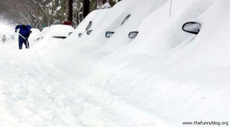
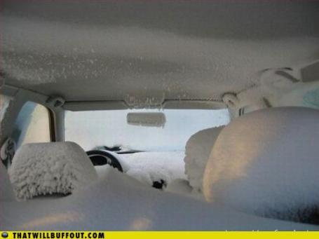
My Car Is In There Somewhere. 1-2 foot snowfall amounts were common from New Jersey and metro New York to Boston and coastal Maine - reports of 3-8 foot drifts in some areas. Winds gusted to 70 mph. in Massachusetts. Thousands of people are still stranded - it was New York's 6th largest snowfall in history (biggest in 4 years). An estimated 50-75 million people were directly impacted, and yet only 5 deaths were directly linked to the blizzard, which is rather remarkable, when you think of it. An update from the New York Times
here.
Blizzard Recap in 38 Seconds. Belmar,New Jersey picked up 32" of snow from the recent blizzard. An enterprising photographer set up a time lapse over 20 hours showing the snow piling up in his yard. Pretty amazing. To see the Vimeo clip click
here.
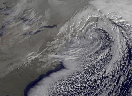
SuperStorm of '10. 8 am visible image on December 27, 2010, courtesy of NASA's Goddard Space Flight Center and Wunderblog. Jeff Masters at Wunderblog
writes that the blizzard was very unusual for a La Nina winter.
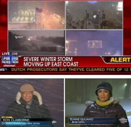
Snowpocalypse. Snowmageddon. Brrrricane? How the networks covered the biggest blizzard in at least 4 years for much of the northeast. Details
here.
Snow Totals:
Elizabeth, New Jersey: 31.8"
Brooklyn, New York: 24"
Newark, New Jersey: 24.2"
Lyndhurst, New Jersey: 29"
Central Park, New York City: 20"
Boston: 16.5"
Snow In The Subway? Yes - it snowed so hard, and the wind blew so strong, that a couple inches of snow accumulated in some of the subway stations in New York City. Read all about it at this
post at neatorama.com.
Stranded JFK Traveler Tweets Ordeal. Read about Jason Cochran's travel ordeal at JFK
here, courtesy of mediabistro.com.
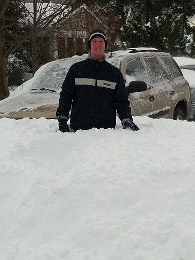
"Hip-Deep!". That's Lee Huffman, our chief programmers, who is currently stranded in northern New Jersey - no flights back to MSP until late Wednesday at the earliest. At least the power is still on - and Lee's family will have a Christmas memory for the ages.
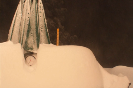
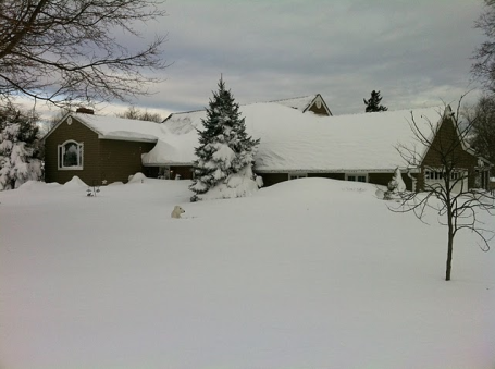
Submerged In Snow. That's a lot of snow (for Minnesota), an unimaginable amount of snow for New Jersey, where 5-8 foot drifts were commonplace.
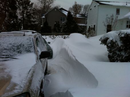
Car-Eating Drifts. Lee Huffman, our chief developer here at WeatherNation/Ham Weather is stranded in northern New Jersey. 29" was reported at Lyndhurst, New Jersey!
Mega-Drifts. That looks like 6-8 foot drifts in parts of northern New Jersey. Photo courtesy of Lee Huffman, from WeatherNation/Ham Weather.
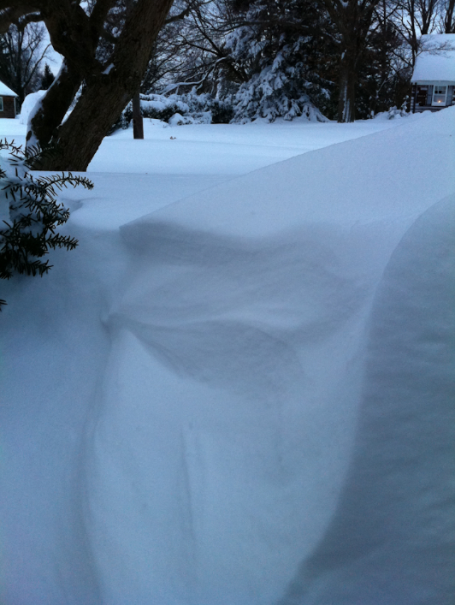
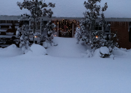
My Front Door Is In There Somewhere! Another photo from northern New Jersey - 6 foot drifts common in the suburbs of New York City (where 2-4" is usually a "big deal").
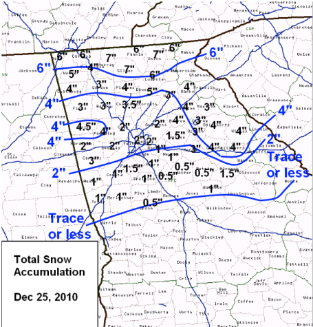
First White Christmas In Atlanta Since 1881! Thanks to meteorologist Dan Lilledahl for passing this weather nugget on to me: 2" for downtown Atlanta Christmas Day. Click
here to read more from the Atlanta office of the National Weather Service.
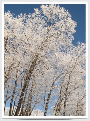
"Hoar Frost." Thanks to Tricia Frostad out in the Lotus Lake, Chanhassen area, for snapping a great photo of Monday morning's hoar frost. Under clear skies with light winds temperatures fell to the dew point - allowing moisture to acclimate (freeze) onto cold surfaces, everything looked like it had white feathers first thing Monday, an amazing site as this icy fog coated tree limbs, sidewalks, everything, with a flakey coating of hoar frost (sometimes called rime ice). More on rime ice from Wikipedia
here.
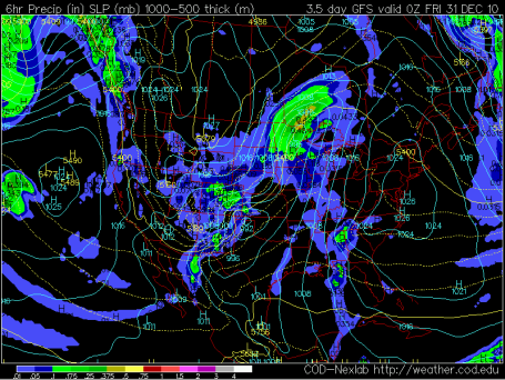
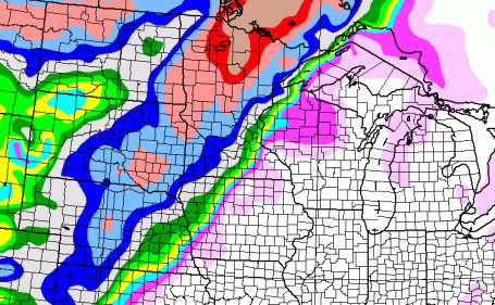
Thursday: A Cold Rain. The GFS model valid 7 pm Thursday evening shows the rain/snow line slicing through central MN, from near Grand Rapids to near St. Cloud and Windom. East of that line, enough warm air aloft for mostly-rain, while significant snow may fall over far western and northern Minnesota on Thursday. Bottom line: the farther north/west you drive, away from MSP Thursday, the worse road conditions will be. The storm may be mostly-snow for Alexandria, Detroit Lakes and Bemidji, a sloppy mix of rain/snow/sleet for Brainerd, St. Cloud and Willmar Thursday, mostly rain for the Twin Cities and Rochester.
Potentially Plowable? It's still too early to panic (or celebrate), but the latest run of the GFS is (still) printing out a fair amount of snow over central, western and northern Minnesota, with potentially "plowable" (3-6") amounts in the Twin Cities - heaviest amounts west metro. If a second storm gets going Friday (temperatures throughout the lowest mile of the atmosphere probably cold enough for all-snow by then) snowfall amounts could be quite significant, especially north/west of the Twin Cities. This could be a fluke, a computer-hiccup. I want to see a few more computer runs to see if there is any continuity from run to run, and model to model. Overall confidence for a New Year's Eve snowstorm is still low (but growing).
Why Should This (Forecast) Be Easy? So the GFS is hinting at as much as 3-6" for the metro on Friday - while the latest NAM, generally the more reliable weather model, is predicting mostly rain for the metro area, with a few inches for far /northernwestern MN. The NAM is NOT predicting a secondary storm arriving Friday - hinting that by the time it's cold enough for snow - most of the moisture will have already swept across the state. It will be interesting to see which model prevails. That's why I talk about "high bust potential" in today's weather column -
confidence level is not high with the prediction of possible snow for New Year's Eve. Right now it's only a chance - far from a sure thing.
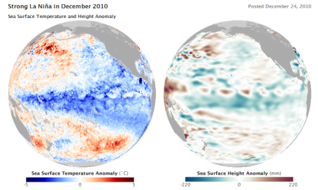
Strongest La Nina In Half A Century? An interesting
story from NASA's Earth Observatory: "This is one of the strongest La Nina events in the past half century, and will likely persist into the northern hemisphere summer, says Bill Patzert, an oceanographer and climatologist at NASA's Jet Propulsion Laboratory. La Nina typically affects weather patterns in North America beginning in January. "For 'normal' effects in the U.S., look for cold in the Upper Plains, dry and warm weather in California, dry weather in the southeast, especially Florida, and unusually soggy weather in the northeast", says Adamec. Because such a wide swath of the Pacific is cold, La Nina tends to keep a lid on global temperatures.
2010, however, was still shaping up to be the hottest year on record in spit of La Nina, according to scientists from NASA Goddard Institute for Space Studies.
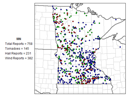
The Wild Weather of 2010. I still can't get past this
graphic (from SPC, NOAA's Storm Prediction Center). 2010 brought 145 confirmed tornadoes to Minnesota. That's 40 more than touched down on Texas, twice as many as Oklahoma experienced this year. Click
here to read a great review of some of the stranger weather/climate events of 2010, a year that was nothing short of extraordinary around the world, courtesy of the blog, Living on Earth.
Best/Worst Tech of '10. Walt Mossberg over at the Wall Street Journal does a great job tracking tech. Here are his
picks for best/worst tech devices of 2010. An excerpt: "
Taking Walt’s top spot this year was none other than Apple’s iPad. For a 1.0 product, the iPad was amazing. With the new iOS 4.2 operating system and its huge selection of apps, the iPad continues to stay ahead of the competition. High-speed 4G networks in the United States took the second spot. As the world goes more mobile, the availability of faster networks is critical. Today, 3G networks are bursting at the seams, and the promise of these networks will be something to watch closely in 2011."
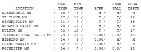
Monday Numbers. The deeper the snow, the colder the afternoon high (as a rule). Snow acts as a refrigerant - cooling the air from below. That's why Rochester only recorded a high of 14 (28" of snow on the ground). With 18" here in the Twin Cities we struggled up to 21, 23 at Duluth (17" on the ground) and 23 at International Falls (15" on the ground). St. Cloud reported 12" on the ground as of Monday evening.
"I Thought YOU Closed The 'Dang Sunroof!"
High Bust Potential
Meteorologists are reluctant to use words like "blunders", "goofs" or "disasters" when describing forecasts-gone-bad. A mistake is a "bust", and a high-bust potential means there is much that can go wrong with the forecast.
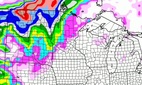
Exhibit A: New Year's Eve. There's little doubt that enough warm air will stream north out of the Gulf of Mexico for mostly rain Thursday (mixed with snow over northern western MN). Models print out a second storm Friday, when temperatures are forecast to tumble through the 20s, cold enough for snow statewide. I want to see a few more model runs before I panic (or celebrate).
But given the FACT that storms tend to strike when they can wreak the most havoc my gut is telling me that Friday could be a mess, wet roads becoming icy as temperatures plummet, a few inches of snow in the metro, maybe some 4-8" amounts central Minnesota - over 10" not out of the question far northern and western MN. The farther north/west you travel, away from the metro New Year's Eve, the deeper the snow piles. This could be a snowy exclamation point coming at the end of what is already the snowiest December on record. Feel like a pioneer yet? Almost makes me long for January.
Best Of The Year In Space. From an
article at gizmodo.com: "It's been a big year for the space sciences. The first privately-held spacecraft orbited our world, the blackest material in history was created, researchers expanded the list of possible sources of life threefold; and that was just in December."
2010: Top 3 Warmest Years; 2000-2010: Warmest Decade On Record. The
latest from the WMO, the World Meteorological Organization: "
The year 2010 is almost certain to rank in the top 3 warmest years since the beginning of instrumental climate records in 1850, according to data sources compiled by the World Meteorological Organization (WMO). The global combined sea surface and land surface air temperature for 2010 (January–October) is currently estimated at 0.55°C ± 0.11°C1 (0.99°F ± 0.20°F) above the 1961–1990 annual average of 14.00°C/57.2°F. At present, 2010’s nominal value is the highest on record, just ahead of 1998 (January-October anomaly +0.53°C) and 2005 (0.52°C)2. The ERA-Interim3 reanalysis data are also indicating that January-October 2010 temperatures are near record levels. The final ranking of 2010 will not become clear until November and December data are analysed in early 2011. Preliminary operational data from 1-25 November indicate that global temperatures from November 2010 are similar to those observed in November 2005, indicating that global temperatures for 2010 are continuing to track near record levels."


No comments:
Post a Comment