Paul's Conservation MN Outlook for the Twin Cities and all of Minnesota:
CHRISTMAS DAY: Santa sightings early. Peeks of sun. Winds: NW 10. High: near 20
SATURDAY NIGHT: Partly cloudy and chilly. Low: 5
SUNDAY: More sun, no travel headaches getting home. High: 15
MONDAY: Bright, ineffective sunlight. High: 16
TUESDAY: Plenty of sun, still quiet and a bit milder. High: 26
WEDNESDAY: Chance of light snow or flurries, risk of a thaw? High: 32
THURSDAY: Last good travel day? Colder with snow possible late. High: 22
NEW YEAR'S EVE: Snow changes to icy mix late. High: 17
NEW YEAR'S DAY: A mix of rain, ice gradually changing over to snow later in the day. High: 26
SUNDAY (January 2, 2011). Snow slowly tapers off - potentially rough travel, especially northern and western MN, where precipitation may fall as mostly snow. High: 19 (falling during the day).
RECORD EVENT REPORT
NATIONAL WEATHER SERVICE CHANHASSEN MN
1250 PM CST SAT DEC 24 2010
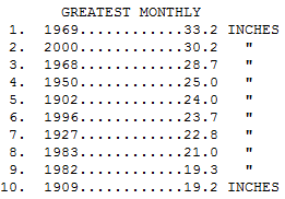
...RECORD DECEMBER MONTHLY SNOWFALL RECORD SET AT MINNEAPOLIS
/ST PAUL MINNESOTA...FRIDAY'S 2.3 INCHES OF SNOW,(SINCE MIDNIGHT),
HAS CREATED A NEW RECORD DECEMBER SNOWFALL OF 33.4 INCHES. THIS
HAS BARELY RETIRED THE OLD RECORD OF 33.2 INCHES SET ON THIS DATE
IN 1969.
An Historic December. If you love snow you're probably out of your mind right about now - we're close to 34" for the month of December, breaking the old record of 33.2" set in 1969. By the way, normal December snowfall in the Twin Cities is close to 10". We pased that number back on December 11. Hey, go big or go home, right? Seems like we got our old Winter Weather Mojo back. Click
here to see month by month snow extremes (most and least) for MSP, courtesy of the MN State Climate Office.
A Significant Clipping.
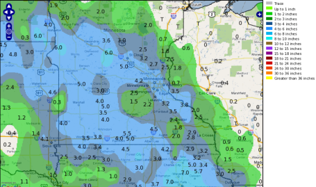
Here, courtesy of the National Weather Service, is a map of Thursday night's snowfall. I can't figure out those "holes" south/west of the metro area - the mysteries and vagaries of the atmosphere....
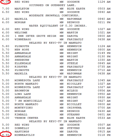
Adding Up The Inches. The coveted (?) Golden Snow Shovel Award goes to Red Wing, where 7" piled up. The northwestern suburbs of the Twin Cities picked up the heaviest snow amounts, a huge swatch of 5-6" (more than predicted by 2") from Long Lake and Plymouth to Annandale and New Hope. Officially MSP picked up a cool 4.6" from the clipper.
A Very (VERY) White Christmas. The definition of a "white" Christmas? At least 1" of snow on the ground. I'd say we have that covered here in the Twin Cities, but roughly the northern half of the USA is waking up to a white Christmas this year. NOAA estimates 45.6% of America has snow on the ground, up from 31.6% of the country last month at this time. On a typical December 25 closer to 35-38% of America has at least an inch of snow. Bottom line: a lot of very happy kids this morning (even though travelers are still grumbling). Hard to keep everyone happy. See the latest snowfall statistics for yourself at NOAA's National Snow Analyses
here.
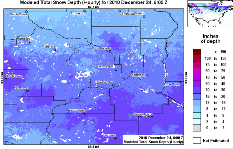
Metro Snow On The Ground. With the exception of a (strange) snowy bullseye over central Anoka county, the south metro definitely has more snow on the ground than the north metro, as much as 20-30" on the ground. Click
here to see NOAA's interactive snow map - pretty cool.
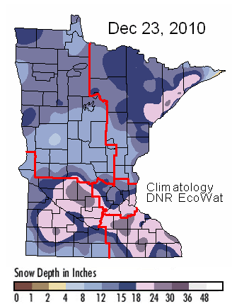
The Big Picture. According to the Minnesota DNR, the heaviest amounts of snow on the ground can be found from near Willmar and Glencoe southeast to Rochester and Lake City, another patch of 24-36" along the North Shore of Lake Superior, enhanced by lake effect snows. Click
here to see the latest map (which doesn't factor in Thursday night's 3-6" of snow). There are updated trail conditions, in case you get a hankering to try some cross country skiing or snowmobiling.
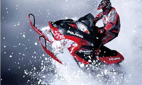
Snowmobilers Rejoice! What a great time to have a sled (or two). Yes, two sleds sounds even better. Oddly enough, the metro area has 2 to 2.5 times more snow on the ground than the Brainerd Lakes area.
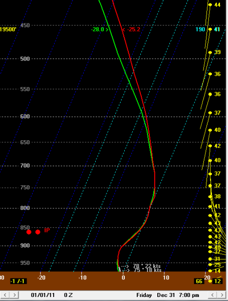
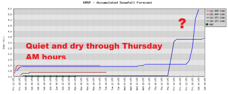
New Year's Eve Ice Event? The Skew-T predictions for 7 pm next Friday (New Year's Eve) show a layer of warmer air aloft, some 3,000 to 6,000 feet above the ground, capable of changing snow over to sleet (ice pellets) or even a little freezing rain. Surface temperatures here at ground level may be in the TEENS - any rain that does fall will instantly freeze on contact. Too early to predict an actual ice storm, but I'm not convinced this next major storm will be all-snow. It all depends on the storm track and intensity of the developing low pressure system - but enough warm, moist air from the Gulf of Mexico may wrap around the system for at least a brief changeover to ice.
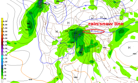
New Year's Weather Headaches? Look, it's way too early to panic (or celebrate), but we all know that major storms are attracted to major holidays. The two just go together, like Sony and Cher, Bill and Hillary, Bonnie and Clyde - you get the idea. At the rate we're going I would not be shocked to see another major snow and ice storm by the end of next week. That old adage, "go with the flow" rings true. Don't fight the "trends". We're in a stormy, snowy rut, and I see no end to this pattern looking out the next 2-3 weeks. This GFS map is valid at 7 pm New Year's Eve, next Friday evening, and it shows the 32 F line at 850 millibars (about 3,500 feet above the ground) surging right over MSP. That could mean snow changing to ice (sleet, ice pellets) as well as freezing rain, rain freezing on contact with cold surfaces. The timing and amounts are still very much up in the air, but I have a (strong) hunch we'll be dealing with another major, travel-busting storm by the end of next week. A changeover to mostly snow is likely New Year's Day as winds increase. Near-blizzard conditions can't be ruled out somewhere in the Upper Midwest a week from today. I'm not predicting a blizzard for MSP, but withing 300-400 miles of the Twin Cities I could see conditions deterioriating to near-blizzard conditions.
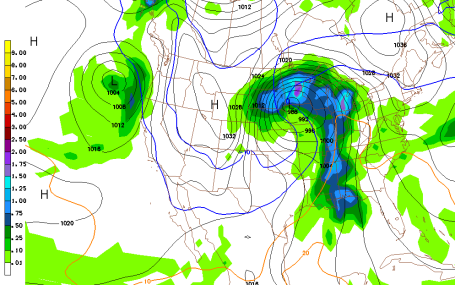
This GFS simulation is valid 7 am next Saturday morning, showing enough warm air wrapping around the storm (over northwestern Iowa) for a possible mix of snow/ice/rain over central and eastern Minnesota, mostly snow from Alexandria and Bemidji into the Red River Valley and far northern Minnesota. Any ice will obviously keep final snowfall amounts down - it's early - but I still believe western and northern MN stand the best chance of very significant snow totals from any New Year's storm. Seems fair, since so far this year the heaviest snowfall amounts have piled up over southeastern Minnesota, where 2-3 times more snow has fallen than over the Brainerd and Detroit Lakes area.
Late Week Storm. The closer next week's storm tracks to the Twin Cities, the greater the odds of a changeover to ice, even a period of rain - which would obviously keep total snowfall amounts down. One thing seems rather certain: no big storms are expected from today through Wednesday night of next week.
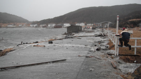
Storm Surge Pounds Newfoundland Community. According to Canada's CBS, at least 15 homes were swept off their foundations by a freak storm surge that swept into this community on the northern tip of Newfoundland. Details
here.
Snowiest December On Record
Is it me or is this starting to feel like an unauthorized sequel of Little House On The Prairie? Santa got in late, delayed by air traffic control, vectored around the Midwest due to low visibility , Rudolph disoriented by more snow than he's seen since the early 80s.
At least 4.6" fell at MSP International, bringing us close to 34" for December. Remarkable. Welcome to the snowiest December on record; modern-day statistics go back to 1891. Normal December snowfall? 10". Right.
Today will be a great day to romp in the snow: peeks of sun, light winds, highs near 20. No worries getting home Sunday, just blue sky and teens.
The first half of next week looks cold but quiet, no weather drama.
The same pattern battering the west coast with a parade of severe storms is contributing to our snowy adventure in Minnesota.
I'm still concerned about a potentially major storm spinning up late next week. A snowy/icy mix could arrive in time for New Year's Eve parties, changing over to mostly snow New Year's Day. Factor in high winds and there is a potential for near-blizzard conditions close to home Saturday. Updates on my weather blog. Hoping you and yours have an amazing Christmas!
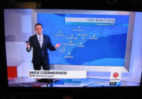
Many TV Weather "Forecasters" Lack Qualifications. From a
story at thestar.com (focusing on Canada):
"
Most so-called TV meteorologists “don’t know what they’re talking about,” says Ian Rutherford, executive director of the Ottawa-based Canadian Meteorological and Oceanographic Society, the national organization dedicated to advancing atmospheric and oceanic sciences, and related environmental disciplines in Canada. The society also endorses TV weathercasters with the proper credentials — “at the very least, professional training and competence in TV or radio broadcasting, and sufficient knowledge of meteorology to communicate weather and climate information in a scientifically correct manner,” Rutherford says — and lists them on its website. By its standards, very few TV weathercasters have the credentials — a bachelor of science degree in meteorology with specialty courses in synoptic meteorology and forecasting — to call themselves meteorologists."
* I believe the situation is marginally better here in the states: an estimated 3 or 4 out of 10 people presenting the weather have a 4-year degree in meteorology from an accredited college. Here in Minnesota St. Cloud State University is the only school that offers a 4 year meteorology degree. The degree is helpful, no question, but the CBM (certified broadcast meteorologist) seal is another signal that the forecaster in question has a clue what they're talking about. My personal (biased) opinion, for what it's worth: anyone can stand in front of a "green-screen" on a sunny day, flap their arms, and impersonate a meteorologist. But on the big storm situations (major tornado outbreaks, floods, winter storms, etc) it's a bit easier to tell who knows their stuff. Here in the Twin Cities we are blessed with an all-meteorologist cast of characters at all 4 stations. There's just too much "weather" to have anyone BUT a professional meteorologist presenting the weather. Phoenix, L.A., even Miami? You can fake it much of the year. Not so here at MSP, where weather often is the news.
. Counterintuitive? Absolutely. But there is sound, peer-reviewed science to back this up. In fact the last IPCC Climate Report predicted more outbreaks of severe winter weather. Water vapor globally has spiked by at least 4% in recent decades, more moisture (fuel) to support not only summer flooding but major winter storms. From a
story in the U.K.'s Independent newspaper: "
Scientists have established a link between the cold, snowy winters in Britain and melting sea ice in the Arctic and have warned that long periods of freezing weather are likely to become more frequent in years to come. An analysis of the ice-free regions of the Arctic Ocean has found that the higher temperatures there caused by global warming, which have melted the sea ice in the summer months, have paradoxically increased the chances of colder winters in Britain and the rest of northern Europe."

Have a Merry Christmas, Paul! Love your blog! :)
ReplyDelete