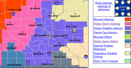
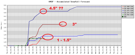
* Second (stronger) storm arrives today, dumping heavy snow on western, northern and parts of central MN. The best chance of heavy snow/ice will come from midday into the late evening hours.
* PM "burst" of 2-4" possible in the metro area, combination of sleet and snow - best chance of 3-4" northern/western suburbs - probably enough snow/sleet to plow/shovel.
* Relatively quiet (dry) start - but travel conditions go downhill as the day goes on. Worst travel expected this afternoon and evening.
* "Dry Tongue", a surge of dry, desert air, will mean slightly lesser ice/snow amounts for eastern and southeastern MN.
* The farther north/west you drive today, away from the Twin Cities, the more snow you'll encounter on highways.
* Worst conditions: north/west of Alexandria, Wadena and Brainerd, where visibilities may fall to near zero in falling/blowing snow - blizzard warnings are posted from Wheaton and Fargo to Detroit Lakes, Fergus Falls, Bemidji and Thief River Falls.
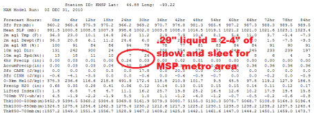
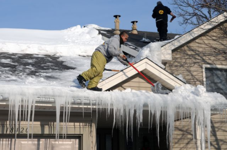
Enough To Shovel/Plow. Yes, probably "plowable". Most likely "shovelable". Not sure that's even a word, but a PM "burst" of snow/sleet during the afternoon and evening hours will accumulate a few inches, enough to make PM driving very tricky.
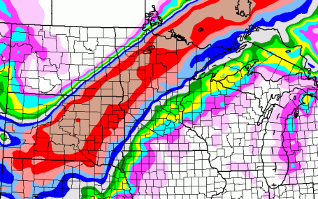
Snowfall Rate. This map is valid at 7 pm this evening, showing the greastest potential for snow falling at the rate of at least 1"/hour between 4 pm and 7 pm today. A "burst" of snow, lasting 4-8 hours, is likely later today, moving from southwest to northeast as the storm lifts into Minnesota.
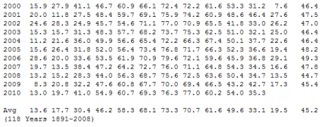
* The average MSP temperature since 2000 is 47.01 F, 1.81 degrees warmer than the 118 year average.
Don't answer that.
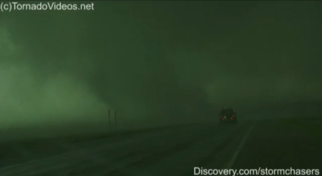
1). 104 Tornadoes, including at least three EF-4 tornadoes. The 1/2 mile wide tornado (captured on video by Discovery.com storm chasers - frame grab above) that hit Wadena was an EF-4, about as strong as they ever get.
2). Heavy rain/flooding of September 22-23. 10.68" of rain swamped Amboy, Minnesota (southern part of the state), resulting in extreme flooding.
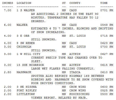
3). Blizzard of December 10-11, 2010. You remember it well: 17.1" fell at MSP, the biggest December snowfall on record, the 5th largest for MSP since 1891.
4). Record low pressure of October 26, 2010. The "Landi-cane" whipped up a central pressure of 28.21" over Bigfork, Minnesota, possibly the lowest atmospheric pressure ever observed between the Rockies and the Appalachians.
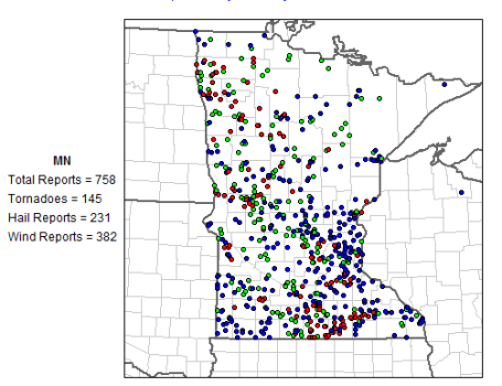
5). Record tornado outbreak of June 17, 2010. A total of 48 tornadoes touched down in a single day, setting a new record for the state of Minnesota. There were 3 deaths and 45 injuries.
I had to add a few more of my own....get it up to a "Top 10" List.
6). Record December Snowfall: 33.4" and counting for the Twin Cities. We may add a couple of inches to that number later today/tonight.
7). Snowless March. Once the "snowiest month of the year" at MSP, March, 2010 was a supreme disappointment for Minnesota snow-lovers.
8). Record September Rainfall for the entire state. 5.53" fell at MSP, more than twice as much as normal for KMSP. More on the unusually wet September here.
9). End to the long-term drought gripping much of Minnesota. Latest drought monitor is here.
10). Snowy May. More snow fell - statewide - in May than in March and April combined. Details here.
Pete Boulay has more details and links focused on some of the biggest weather/climate stories of 2010. Thanks Pete!
1. From Rain to Blizzard Jan 23-25 2010 http://climate.umn.edu/doc/journal/blizzard100123_25.htm (19 inches of snow in Cook County)
2. Snowless March 2010 http://climate.umn.edu/doc/journal/lackofsnow1003.htm
3. Warmest March on Record at International Falls http://climate.umn.edu/doc/journal/warm1003.htm
4. Snowy May 7 http://climate.umn.edu/doc/journal/100507_09snow_and_cold.htm
5. 48 Tornadoes on June 17 http://climate.umn.edu/doc/journal/tornadoes_100617.htm
6. Wilkin County Tornado: August 7 http://www.crh.noaa.gov/fgf/?n=20100807_tor_wilkin
7. Heavy Rain and Flood of September 22-23 http://climate.umn.edu/doc/journal/flash_floods/ff100924.htm
8. November 13-14 Heavy Snow (tree branch breaking storm) http://climate.umn.edu/doc/journal/snow101113.htm
9. Record Low Pressure http://climate.umn.edu/doc/journal/low_pressure_101026.htm
10. December 10-11 Blizzard (17.1 inches in the Twin Cities) http://climate.umn.edu/doc/journal/snow101210_11.htm
11. 104 Tornadoes for 2010 http://www.crh.noaa.gov/images/mpx/2010torlist.pdf
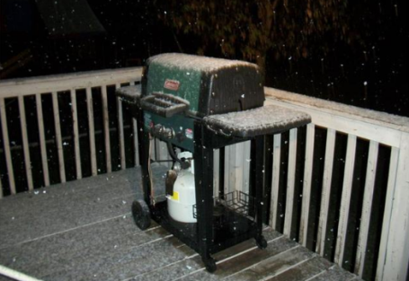
Snow at North Branch in Chisago County, May 7, 2010. Courtesy Patrice Ramaley and the MN State Climate Office.

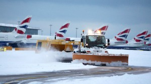
* Bloomberg's Blizzard Blunder. More fallout from the handling of the 2-3 feet of snow that buried metro New York last weekend, although the latest news stories are suggesting that sanitation and snow removal crews may have intentionally "slowed things down" to rack up more overtime. I Love New York...
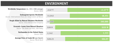
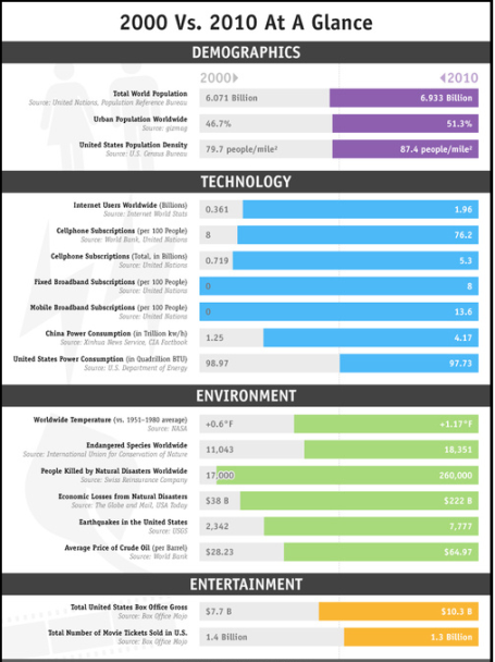
Troubling Trends. This "infographic" from io9.com caught my eye. A 1.17 F. global temperature rise since 2000. A 61% increase in endangered species in just a decade. A 15X spike in deaths attributed to natural disasters in only 10 years? Economic losses went from an average of $38 billion/year in 2000 to $222.8 billion/year in 2010. Most ominously, the price of crude went from $28/barrel to $64/barrel over a ten year period. Even accounting for minor inflation that's a pretty big jump.

10 Ways To Get The Most Out Of Technology. From a recent New York Times article: Your gadgets and computers, your software and sites — they are not working as well as they should. You need to make some tweaks. But the tech industry has given you the impression that making adjustments is difficult and time-consuming. It is not. And so below are 10 things to do to improve your technological life. They are easy and (mostly) free. Altogether, they should take about two hours; one involves calling your cable or phone company, so that figure is elastic. If you do them, those two hours will pay off handsomely in both increased free time and diminished anxiety and frustration. You can do it."

450 PM CST THU DEC 30 2010


...RECORD DAILY MAXIMUM RAINFALL SET AT ST CLOUD MN TODAY...

A RECORD RAINFALL OF 0.74 INCH WAS SET AT ST CLOUD TODAY.

THIS BREAKS THE OLD RECORD OF 0.46 SET DEC 30 2006.


...RECORD MONTHLY MAXIMUM PRECIPITATION SET AT ST CLOUD MN TODAY...

THE MONTHLY PRECIPITATION TOTAL OF 2.37 INCHES SETS NEW MONTHLY RECORD

EXTREME FOR ST CLOUD. THE OLD RECORD WAS 2.04 INCHES...SET IN DECEMBER 1969.


MORE PRECIPITATION IS EXPECTED BEFORE THE END OF DECEMBER.
Climate Data: Thursday's high was 41 in the Twin Cities with at least .25" of rain, the snow on the ground melted from 17" to 13" in less than 24 hours.
Paul's Conservation Minnesota Outlook for the Twin Cities and all of Minnesota:
NEW YEAR'S EVE: Icy. A mix of sleet and freezing rain changes over to mostly-snow by late afternoon/evening. 2-4" of snow/sleet possible afternoon/evening hours. Winds: NE 10-15. High: 24 (layer of ice possible under the sleet and snow - will make for tricky travel as the day goes on).
FRIDAY NIGHT: Snow tapers to flurries late - icy travel, very treacherous conditions over much of the state Low: 2 (wind chills dipping to -15).
NEW YEAR'S DAY: Arctic breeze, few flakes - little additional accumulation. Wind chills dip to -10 to -15 at times. High: 11
SUNDAY: Coldest day, no travel problems. Intervals of sun. Low: -3. High: 8
MONDAY: Clouds increase, late flurries possible. High: 15
TUESDAY: Flurries taper, PM sun. High: near 20
WEDNESDAY: More clouds than sun, "average" temperatures. High: 23
THURSDAY: Peeks of sun, still quiet and storm-free. High: 24
Increasingly Icy
Yesterday, my faced pressed up against the office window, I kept thinking "what a waste of perfectly good moisture." Had it been 2-4 degrees colder we might have picked up 6-8" Thursday, adding to our record 33.4" December snowfall here in the cities.
Warnings are posted north and west, a cool foot or more of snow will plaster Fargo, Bemidji and Thief River, maybe 6-9" of badly needed snow for Brainerd, 3-5" St. Cloud, while MSP picks up an icy 2-4" of sleet and snow this afternoon and tonight. A few factors coming into play - with the storm tracking right over the metro the "dreaded dry tongue", a surge of dry, desert air aloft, will keep amounts less over eastern MN.
But wet roads and puddles turn to ice later today as temperatures tumble. The farther north/west you drive, away from the metro, the heavier the snowfall amounts. We just get a taste here in the metro area.
What a year: 104 tornadoes in Minnesota, most in the USA. Record floods, snow-less March, and temperatures in the metro 2.7 F warmer than average. More on my blog. As you shake your fist at a New Year's Day cold front consider this: we've picked up 4+ minutes of daylight since Dec. 21. Spring's coming. I think.
* Why Even Skeptics Should Tackle Climate Change. A thought-provoking article here.
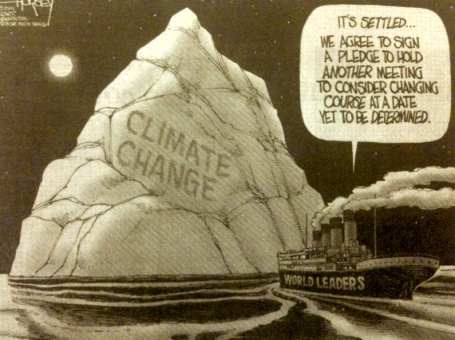
Why? In large part because of a concerted, coordinated, aggressive campaign by a small group of well-funded climate change deniers and contrarians focused on intentionally misleading the public and policymakers with bad science about climate change. Much of this effort is based on intentional falsehoods, misrepresentations, inflated uncertainties, and pure and utter B.S. about climate science. These efforts have been successful in sowing confusion and delaying action - just as the same tactics were successful in delaying efforts to tackle tobacco's health risks.
To counter this campaign of disinformation, we are issuing the first in what may become a series of awards for the most egregious Climate B.S.* of the Year. In preparing the list of nominees, suggestions were received from around the world and a panel of reviewers - all scientists or climate communicators - waded through them. We present here the top five nominees and the winner of the 2010 Climate B.S.* of the Year Award.
The entire story is here.
No comments:
Post a Comment