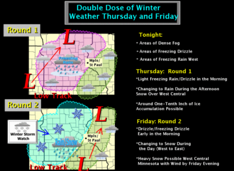
Storm Headlines:
* Dense fog into Thursday may drop visibility close to zero at times over southeastern MN, including MSP metro area.
* Rain today for the Twin Cities may end as a little slush this evening, but most roads will be wet much of today.
*
Today will be the better travel day across most of Minnesota - many roads across central and southern MN just wet and slushy. I expect snow-covered roads across far western MN, where 3-5" may fall today.
* Icy mix for central Minnesota today, mostly snow for far western MN, where 3-5" may accumulate today.
*
Second storm arrives Friday, with the heaviest amounts over western MN (
more of a dry, powdery snow prone to blowing/drifting and low visibilities). I could still envision near-blizzard conditions for much of western MN and the Red River Valley during the PM hours on New Year's Eve.
* Twin Cities on the edge of a "plowable" snowfall Friday. Icy mix (freezing rain/sleet) changes to snow by afternoon and evening, potential for 2-4", best chance of 3-4" western metro.
Travel conditions will get worse as the day goes on tomorrow, as temperatures drop, visibility lowers and winds increase.
2 Rounds. Click
here to see a good overview of the storm from the local (Chanhassen) National Weather Service office. Round 1 comes today, mainly rain for the metro, a mix over central MN, mostly snow for far western MN, where 3-4" of slush may accumulate. Round 2 surges in from the south Friday, and I have a (strong) hunch that travel conditions will be much worse on New Year's Eve. Why?
1). Colder temperatures: 20s metro, teens and single digits far western Minnesota. Snow will accumulate faster, the chemical mix used by MnDOT doesn't work nearly as well when it's that cold.
2). More wind. Winds will reach 20-30 mph across central and western MN, not quite blizzard criteria, but you can expect low visibility tomorrow.
3). Icy mix. I'm concerned that today's wet/slush roads will become icy as temperatures fall through the 20s, then we'll have a few inches of snow on top of the ice. A 1-2 punch, which will make for very unpleasant conditions on area highways.
4). The later in the day you drive tomorrow, the worse conditions will be on Minnesota's roads. If you can leave today you'll thank yourself down the road. Trust me, I'm a weatherman.
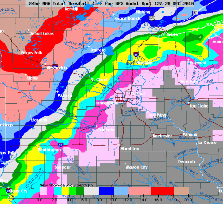
Huge Variations. The latest NAM/WRF model is hinting at an inch or two for the metro (maybe some 3-4" amounts far western suburbs, west of Delano, Medina and Albertville). Some 3-6" amounts are possible for the St. Cloud area, with over a foot predicted for west central and northwestern MN, most of that snow coming on New Year's Eve.
How Much? Yes, that's an 12-16" bullseye over the Red River Valley and much of northern Minnesota, from Detroit Lakes to Bemidji and International Falls, where precpitation will fall as mostly snow Thursday and New Year's Eve. Two distinct areas of low pressure will ripple northeast along the leading edge of our next Arctic outbreak. Wave #1 produces mostly rain for much of central and southern MN Thursday (about a tenth of an inch of liquid - definitely not helping the ice dam situation). Wave #2, a stronger area of low pressure, arrives New Year's Eve. By then it should be cold enough for snow statewide, but as is often the case the heaviest snow bands are forecast to set up north/west of the storm track, over the northern and western third of Minnesota.
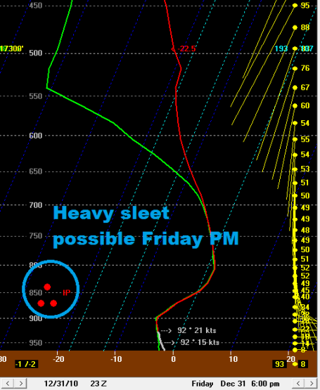 1-2" Sleet Friday Afternoon?
 The latest Skew-T analysis of what the atmosphere SHOULD
look like over the next 84 hours has me concerned about the potential for moderate to heavy sleet (ice pellets) during Friday afternoon, changing over to mostly snow Friday evening/night.
I wouldn't be surprised to see 1-2" of sleet - not as dangerous as freezing rain/glaze ice, but with temperatures in the mid/upper 20s I could envision a thin layer of ice on many highway surfaces, followed by 1-2" sleet, topped off with an inch or so of snow. Translation:
icy mess PM hours tomorrow.
* One surge of wet snow is likely across western/central/northern Minnesota this afternoon (while staying mostly rain in the Twin Cities metro area). A second surge of snow arrives Friday, best chance afternoon/nighttime hours.
Between the 2 separate storms here is how much snow I'm expecting:
Twin Cities: 2-4" (most of that coming PM hours Friday, best chance of 3-4" far west metro)
St. Cloud: 3-5" (one shot coming Thursday PM, another surge of snow arrives Friday).
Alexandria: 8-11" (3-5" tomorrow, another 4-5" possible New Year's Eve, when winds will be stronger, temperatures colder and visibility lower).
Brainerd Lakes Area: 5-8" (3-4" Thursday PM hours, another 3-4" Friday).
Mankato: 3-4" (almost all of that coming on New Year's Eve).
Detroit Lakes Area: 8-12" (4-6" Thursday, another 4-6" on Friday).
Bemidji: 12-14" (4-6" today, another 8-10" possible Friday).
Fargo/Moorhead Area: 8-12" (4-6" Thursday, another 4-6" Friday).
Grand Forks/Crookston Area: 12-16" (3-6" slushy snow today, another 6-9" of light, fluffy, powdery snow Friday, prone to blowing/drifting).
Duluth: 3-6" (inch or two of slushy snow tomorrow, mix likely. Another 2-4" on Friday).
Rochester: 1-2" (coming Friday PM and nightttime hours).
Sioux Falls, SD: 4-6" (inch or two of slushy snow today, another 3-4" Friday).
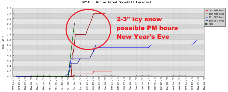
Probably Plowable For The Metro Area. The latest models are suggesting 2-3" of snow (and sleet, ice pellets!) late Friday into Saturday morning, the brunt of the heaviest snow bands setting up 75-200 miles west of MSP.
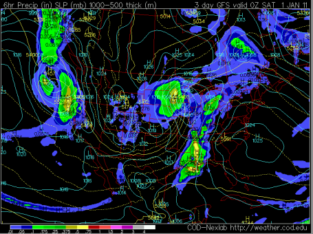
Height Of The Storm? Friday evening at 7 pm the GFS shows the center of low pressure in the vicinity of Rochester, Minnesota, the shield of heaviest snow over central and western Minnesota and the eastern Dakotas. The track will be critical - if the storm tracks farther east then snowfall amounts could be more impressive in the metro area.
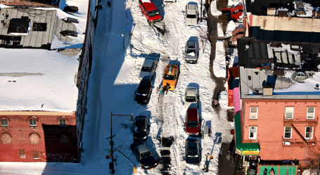
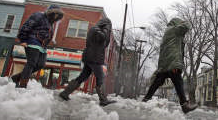
New York Struggles As Blizzard's Impact Chastens Bloomberg. What a mess. 5 days after the Blizzard of '10 many (smaller) streets are still not plowed out - people can't get to work, can't get to the store. Locals are angry, venting to City Hall. There have been a handful of cases where major storms (handled poorly) have led to the ouster of mayors from Boston to Chicago. I wonder if Mayor Bloomberg is going to survive this (I suspect he will). More on the Big Apple's debilitating snow-blitze from the New York Times
here.
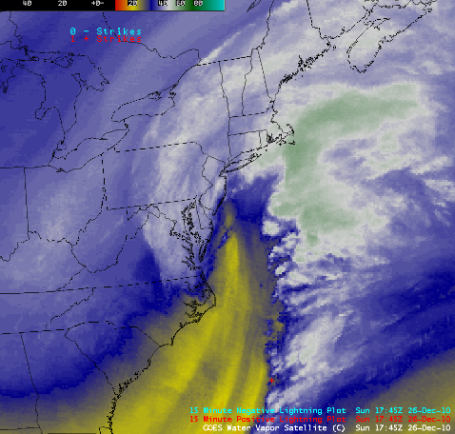 Northeast Blizzard From Space
. Click
here to see the U. of Wisconsin CIMSS enhanced infrared satellite loop showing the powerful storm that dumped 1-3 feet on much of New England last weekend. It moved slowly, tapping a huge fetch of moisture off the Atlantic, dumping countless BILLIONS of tons of snow on the northeast.
"Sopranos" Star Is A Blizzard Hero. From an
article in the New York Post:
"Sopranos" star James Gandolfini came to the rescue of a stricken motorist who got stuck on unplowed Bedford Street in the West Village on Monday night. The beefy actor, who lives in the neighborhood, helped dig and then push out the stranger's car--and then popped into nearby bar and restaurant Daddy-O to change a $100 bill to tip others who pitched in to help out."
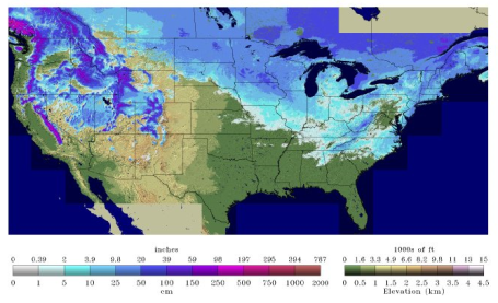 The United (Snow-Covered) States of America
. At last report on 5 southern states were snow-free as of midweek. Click
here to see the latest from NOAA's National Snow Analyses site.
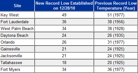
Misery Loves Company. At least you didn't shell out hundreds or thousands of bucks to sprawl out on the beaches of Florida this week. Ouch. Check out some of these new record lows across Florida, courtesy of the National Weather Service. More details
here.
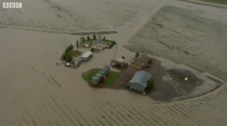
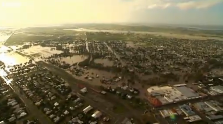
Severe Flooding in Australia. Queensland, in northeastern Australia, has been hit very hard by rain in recent days and weeks. Hundreds have been evacuated from their homes. According to the
BBC several areas have been declared disaster zones.
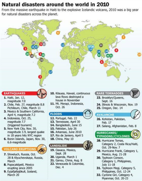
2010's Biggest Natural Disasters. It was an amazing year, 19 nations set all-time record highs (a record in and of itself), and for a time last summer it seemed we were enduring 1-in-500 year floods somewhere on the planet. From a good
summary of the year from MSNBC:
"The natural forces of the planet were in full swing this year, with some spectacular and devastating consequences. From the massive Haiti earthquake to a bevy of explosive volcano eruptions, 2010 saw its share of natural disasters across the planet. Here are some of the headline-grabbing natural disasters that OurAmazingPlanet and its sister sites covered in 2010."
iPad 2 Rumor Round-up. Version 2.0 of the iPad is predicted to have not one, but two cameras, a USB port, possibly constructed of light-weight carbon fiber. More details from gizmag.com
here.
Atmospheric Oops! ASHEVILLE — The Wilmington jeweler who said he’d refund purchases if it snowed 3 inches or more in Asheville on Christmas Day is paying up. It will take about 45 days for his insurance company to cut checks for customers who bought jewelry at Perry’s Emporium in Wilmington between Nov. 26 to Dec. 11, owner Alan Perry said. “The customers are coming in like crazy, bringing their receipts, he said. He was sitting on the beach in Montego Bay, Jamaica, the day after Christmas, sipping a rum punch, when his store manager emailed to say that Asheville had gotten slammed. “One woman I know, a real estate agent in Wilmington, was in Asheville visiting her mother, and she was sending photos (of the snow) to my iPad,” Perry said. “She said, ‘you’d better get out your checkbook.’” Perry estimates the payout at close to $400,000. The insurance policy cost less than 10 percent of that. He thinks he’ll let people come in for their checks on Feb. 13, the day before Valentine’s Day. He’s thinking about running a similar promotion on Feb. 14 called “Second Chance.” Valentine purchases will be free if it snows more than a certain depth in Asheville on that day. “I’ll have to find out what the insurance company will charge me,” he said.
Local jeweler offers similar deal.
An Asheville jeweler is offering a similar deal. Alan’s Jewelry and Pawn will refund purchases made between Nov. 26 and Christmas Eve if it snows 2 inches or more at the Asheville airport between 6 p.m. and midnight on Jan. 1. The National Weather Service says showers are likely on Saturday, with a high near 56. In the 12 years that Alan’s Pawn has been running the promotion, they’ve never had to pay out, Tonia Sheppard said.
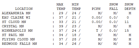
Where Are We Living? Yes, this is the humorously pathetic time of the year when 37 feels like a breath of fresh air! Wednesday's high was 14 degrees above average - much of Minnesota enjoyed a well-deserved thaw, as mild as 39 at Crystal, 33 at St. Cloud, only 29 at Alexandria.
Paul's Conservation Minnesota Outlook for the Twin Cities and all of Minnesota:
THURSDAY: Dense Fog Advisory. A little ice possible early, then a cold rain. Most major roads will be wet/slushy. Winds: S 10-15. High: 38
THURSDAY NIGHT: Fog and rain tapering as a little wet snow - probably little accumulation in the metro area, but wet/slushy roads will become icy as temperatures fall into the 20s. Low: 25
NEW YEAR'S EVE: Icy mix of freezing rain/sleet/snow changes over to all snow PM hours, 2-3" sleet/snow metro late Friday? High: 26
FRIDAY NIGHT: Windy with snow tapering to flurries late. Treacherous travel conditions over much of northern/western with near white-out conditions possible north/west of Alexandria, Wadena and Bemidji, MN. Low: 3
NEW YEAR'S DAY: Snow tapers to flurries. Arctic breeze, travel gets better with intervals of PM sun. Wind chill: -10 to -20. High: 11
SUNDAY: Blue sky, smells like the Yukon. Low: -3. High: 6
MONDAY: Patchy clouds, flurries north. high: 16
TUESDAY: Some chilled sun returns. High: 15
WEDNESDAY: Clouds increase, PM flakes? High: near 20
Slush, Mush and Goo
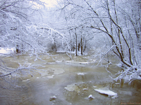
"One resolution I have made, and try always to keep, is this: To rise above the little things," wrote John Burroughs. And then you realize that nearly everything is a "little thing". Unless you want to drive into western Minnesota on New Year's Eve. That will cost you extra (in time and aggravation). A two-prong storm is still on track - enough warm air aloft for rain today. The result, even more ice dams and a few shoe-killing, pond-size puddles.
A Winter Storm Watch for northern and western Minnesota implies 6"+ snowfall amounts from this afternoon through Friday night. One model is hinting at 2 FEET of snow for Fargo. Conditions worsen the farther north/west you drive New Year's Day; try to get out today or first thing tomorrow. Near white-out conditions are possible Friday PM hours west of Willmar and Wadena. 2-3" falls on the metro, 3-6" St. Cloud, 6-8" for Brainerd, maybe 10" at Alexandria, with over a foot north/west of Detroit Lakes and Bemidji.
Good news for up-north resorts, where snowfall has been minimal (only 5" on the ground at Brainerd, but 27" at Rochester). Travel conditions improve New Year's Day as Canada springs a leak; but not as Nanook as 2 weeks ago.
Minnehaha Creek To Get More Curves. I've gone canoing down the Minnehaha Creek (the Twin Cities metro area is one of the few urban areas where you can actually canoe across a large portion of the metropolitan area). The Star Tribune has a
story about the "improvement" of the creek - a few apartments and other buildings apparently have to come down during the pending reclamation project.
East Coast Storms Signal Effects Of Climate Change: Weather Expert. The U.K. Globe and Mail has a
story linking the excessive amounts of snow from last week's New England blizzard with an increase in water vapor worldwide, a spike in atmospheric moisture linked to more frequent/extreme outbreaks of flooding as well as more severe winter storms. An excerpt: "
Weather experts say New Brunswick is already experiencing the punishing realities of climate change, particularly rising sea levels and damaging storm surges. Recent storms have caused more than $50-million in damage and untold grief for home and cottage owners and coastal expect Robert Capozi warns floods and surges are a fact of life under the new “coastal realities” dictated by the earth's changing climate."
How A Drinking Glass May Enhance Climate Models.
Satellite image of a 1992 dust storm over the Red Sea and Saudi Arabia. (Credit: NASA) Dust plays a significant role in controlling the Earth’s temperature — some dust particles cool the planet by reflecting solar energy, while others heat the planet by trapping solar energy in the atmosphere
. More from talkingscience.org. This week, researchers
announced that ordinary drinking glasses and atmospheric dust particles break apart in the same fashion. Dust, like many other brittle objects, fractures in a way that produces a predictable size distribution of fragments.


No comments:
Post a Comment