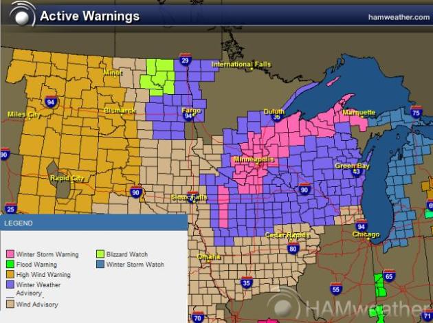
Major Winter Storm For Western Minnesota. The Twin Cities metro may wind up with a couple inches of snow during the PM hours Friday, New Year's Eve. But conditions will be MUCH worse over the western third of Minnesota, where as much as 12-18" snow may pile up by New Year's Day. Try to get your travel done by Thursday evening - you probably won't want to be on the highways (west of Alexandria and Wadena) by New Year's Eve.
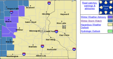
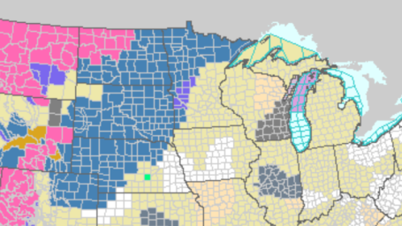
Latest Watches - Warnings. Click here to see the very latest updates from NOAA. The northwestern third of Minnesota is under a Winter Storm Watch - with advisories for an icy mix near Alexandria and Wadena. I have a hunch the watch area may be expanded - with an upgrade to warnings within 12-24 hours.
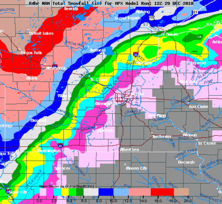
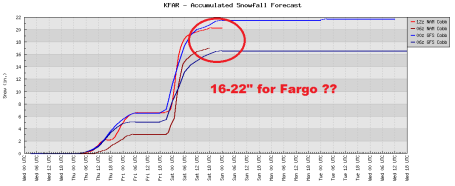
1-20", Give Or Take. If I were to issue a forecast with a 20" range in snowfall amounts the men with the little white jackets would show up in my office to lead me away. But that appears to be what Minnesota is facing, a couple inches of snow in the Twin Cities metro area, maybe 3-6" for St. Cloud, 5-8" Brainerd, nearly a foot in Alexandria with some 12-16" amounts possible north of Fergus Falls and Detroit Lakes. One model is printing out over 20" for the Fargo/Moorhead area. A few inches may fall tomorrow afternoon far north/west (rain for the metro and St. Cloud), but a second surge of moisture arrives New Year's Eve - by then the atmosphere will be cold enough for all snow, the heaviest amounts coming 75-200 miles north/west of MSP.
Potentially Crippling For Fargo? On our (patented) "nuisance - plowable - crippling" snowfall scale, this will be plowable north/west of the Twin Cities, Willmar, St. Cloud and the Brainerd Lakes area, but from Detroit Lakes to Fargo/Moorhead to Bemidji this could be a crippling snowstorm on New Year's Eve, a treacherous combination of snow, wind, poor visibilities and potentially dangerous wind chills.
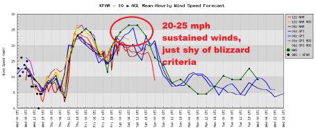
Close To Blizzard Criteria Across the Red River Valley? Friday's snow will be accompanied by 20-30 mph sustained winds. A blizzard requires sustained winds of at least 35 mph. We'll be close, and since temperatures will be cold (single digits and low teens) I expect a dry, fluffy, powdery snow - prone to blowing and drifting. You may not want to be driving north/west of Alexandria, especially New Year's Eve.
No comments:
Post a Comment