Paul's Conservation Minnesota Outlook for the Twin Cities and all of Minnesota:
TODAY: Intervals of sun, possible thaw. Winds: S 10-15. High: 33
WEDNESDAY NIGHT: Cloudy, a little light rain or freezing rain (glaze ice) is possible late. Low: 30
THURSDAY: Unseasonably mild with periods of rain for the metro (mainly wet roads). Snowy mix far north/west MN. High: 36
NEW YEAR'S EVE: Changeover to snow - 2-4" possible metro area afternoon and nighttime hours, more north/west of MSP. High: 28 (falling through the 20s into the teens Friday night, meaning wet/slushy roads will become icy).
SATURDAY: Better travel, cold wind whips up with intervals of sun. High: 11 (wind chill dips below zero).
SUNDAY: Sun helps (a little). Brrrr Low: -3. High: 14
MONDAY: Clouds increase, not as bitter. High: near 20
TUESDAY: More clouds than sun, quiet. High: 22
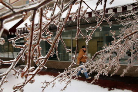
Icy Possibilities. Although temperatures 3,000 to 6,000 feet above Minnesota are forecast to be warm enough for rain late Wednesday night and Thursday - that rain, falling on sub-freezing surfaces (sidewalks, driveways, powerlines and tree limbs) may produce a thin layer of glaze ice, especially Thursday morning, before the breakfast hour. The best chance of icing will come north/west of the Twin Cities, closer to Willmar, St. Cloud and Little Falls.
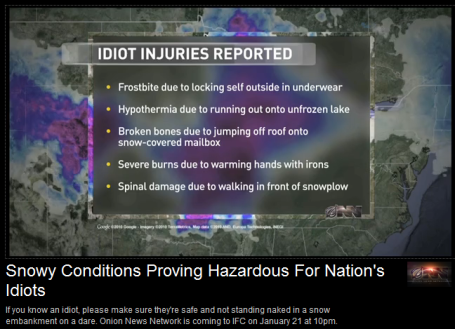 Snowy Conditions Proving Hazardous For Nation's Idiots
. Summing up the recent blizzard as only The Onion can, check
this out. One of the funnier things I've seen recently (apologies to any idiots, related or unrelated, who may be offended by this attempted satire).
*
Bad Weather Karma? Not sure if you caught this during last night's Vikes-Eagles game, but so far this season the Vikings have had 2 weather-related postponements. By comparison the Twins had only 1 weather-related cancellation in 2010 at the new Target Field. Tuesday's game was the first NFL football game played on a Tuesday in 64 years. Good grief....
Eagles Are Knee Deep In Controversy After Postponement. Has there ever been such a harsh reaction to the postponement of a football game due to weather? I doubt it. From an
article in the New York Times: "
It is a rare moment when a snowstorm-prompted game postponement turns into a referendum on the nation’s level of “wussiness,” but such is the occasion when someone slips a radio microphone near the mouth of Pennsylvania Gov. Ed Rendell. He unleashed his own unique kind of storm on the N.F.L. for moving his beloved Eagles’ game to Tuesday instead of playing it Sunday in a blizzard. Whether you agree with Rendell’s contention that we’ve become a “nation of wusses,” you do have to admire his rhetorical touches. “If this was in China, do you think the Chinese would have called off the game?” he railed. “People would have been marching down to the stadium, they would have walked and they would have been doing calculus on the way down.”
What do you think? Is it better to err on the side of caution - or let people determine their own level of risk, whether they want to head out into the weather? I can see both sides of this one. Sadly, the lawyers are now in control. Everything is predicated on risk and liability and "exposure". I think the good governor of Pennsylvania has a valid point, but all it would have taken is one fatal accident after the game in Philly for the (legal) Hammer of God to come down on the NFL. It's a no-win predicament.
"I Love New York (But Never Leave A Vehicle There During A Snowstorm). Is this any way to treat a Ford Explorer? New York Sanitation Workers were trying to free a front-end loader, and it just turned into something out of Candid Camera. Click
here to see the entire clip (rated R for salty language).
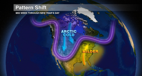
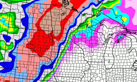
Shifting Pattern. The jet stream, the high-speed river of air snaking its way around the Northern Hemisphere, is about to buckle, plunging more bitter air southward out of Canada. We've had a Pacific flow much of this week (low 30s today, possibly mid 30s by Thursday, more than 10 degrees above average for late December). Along the leading edge of this next Arctic Fling a series of low pressure systems will impact Minnesota, enough warm air aloft for mostly-rain Thursday, but by Friday there should be enough cold air in place for a couple inches of snow in the metro - it may be considerably MORE than a couple inches for far western/northern Minnesota. There, a plowable snowfall is likely.
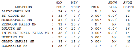
On The Edge - A Cool Foot for Western Minnesota? As if so often the case, the Twin Cities metro area may wind up on the edge of any significant snowfall with Friday's system. Best bet locally based on what guidance is suggesting is something in the 2-3 or 2-4" range, best chance of 3 or 4" west of Minneapolis, maybe only a coating to an inch or so far eastern suburbs, where more precipitation will fall as rain. But parts of central Minnesota could easily wind up with 3-6", maybe closer to 8-12" from Alexandria to Brainerd with some 12"+ amounts for the northwestern third of Minnesota. Rochester has 28" on the ground, Brainerd has less than 6". It's about time the "up north" part of Minnesota catch up a little in the snowfall department.
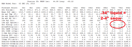
Ice - Rain - Snow (In That Order). If rain streaks in late Wednesday night (possible) surface temperatures may be just below the freezing mark - I could see some icy bridges and side streets early Thursday morning, but I think most roads will wind up being wet on Thursday. We get a little break before the main (secondary) storm spins up Friday, models printing out .34" liquid PM hours on New Year's Eve - plenty of cold air in place for snow. If the current track holds some 2-4" amounts are possible in the metro, amounts increasing the farther west you travel on 7, 12 and I-94.
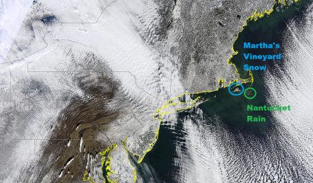
Fresh Carpet of White - Tale of Two Islands. NASA's high-res "MODIS" Terra satellite showed the fresh snow blanketing the east coast. I also found it (vaguely) interesting to see what a difference the rain/snow line makes. Nantucket, close to 60 degree Gulf Stream waters - stayed rain, while 20 miles west fresh snow coated Martha's Vineyard, MA. Click
here to see the high-res image.
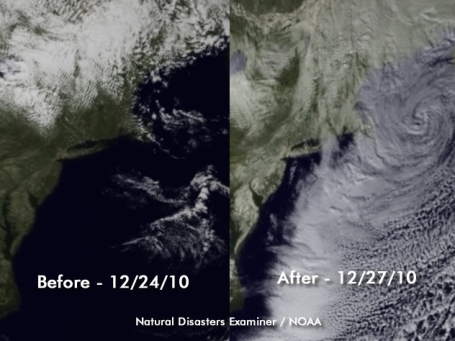
Blizzard Before And After Photo. The recent blizzard was a coastal affair, very little snow west of Philadelphia and Baltimore, the greatest surge of snow (and wind) focused on coastal New Jersey right up the coast to Boston and Portland. The New York Times has a great op-ed piece about the "Boxing Day Storm" that resulted in the "
White Coast" here.
 An Unusual Number of Top 10 Snowstorms For The Northeast
. Jeff Masters in his excellent
Wunderblog looks at the latest New England blizzard - his research shows a sharp spike in the most extreme snowfalls in recent years, and wonders (out loud) if it's a fluke, or yet another sign of climate change, an increase in evaporation and water vapor spiking winter storms, making them more potent than ever. Worthy of a read.
Record Rainfall...Record Snowfall. And 2010 Is One Of The Warmest Years On Record? Southern California Public Radio has a good overview of the crazy year that was 2010. An excerpt from the
article: "
You don’t need a degree in climatology or meteorology to observe that the weather in 2010 has been strange, downright bizarre in December with record rainfall in Southern California and a blizzard for the ages socking the East Coast. Early snow in Seattle, extreme snow and cold conditions across the northern plains… and throw in a few more massive blizzards in Europe and winter came very early in 2010. Right on cue, the World Meteorological released its analysis of the year’s temperatures showing that 2010 will probably be among the three warmest years on record, and that 2001 – 2010 will be the warmest decade on record. How does one reconcile all of the cold temperatures, snow and rainfall with the continued evidence that global warming is happening and even accelerating?"
The Blizzard of 2010. Has Global Warming Turned Americans Into Winter Wimps? An interesting
article (cry in the wildnerness?) from the Christian Science Monitor. Here is an excerpt: "
Maybe it was those warm, snow-bare years and the impression that global warming was in the process of turning Minneapolis into Miami, but what's with the hyperbolic national reaction to the "snowball express" winter storm of 2010?" The hand-wringing by news anchors up and down the East Coast was on Sunday compounded by the postponement – before a flake of snow had fallen – of the Philadelphia Eagles-Minnesota Vikings pro football game, causing Pennsylvania Gov. Ed Rendell to fume: "This is football; football is played in bad weather."
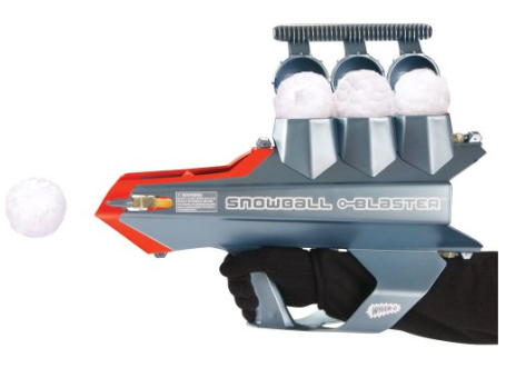
Mega-SnowBall Launcher. The next time the kids gang up on your go into the garage and pull
this thing out of cold storage, all of $30 from the Hammacher Schlemmer catalog. The next thing you'll hear is a lot of screaming (running) as the troops scatter. I need one of these....
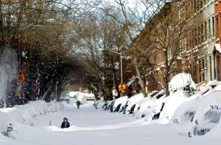
Welcome Thaw. For only the third time this month the mercury rose above freezing in the Twin Cities. Yes, sadly, 34 felt pretty good (10 degrees above average for a change). Rochester is still reporting 27" snow on the ground, 16" MSP, 12" St. Cloud, less than 5" for parts of the Brainerd Lakes area - where folks are due for a real snow storm.
Brewing Slop-storm
It could be worse. You could be trying to find your front door in Elizabeth, New Jersey, where 32" fell with 8 foot drifts. You could be foraging for food at JFK, an oasis of discomfort surrounded by a vast, snowy wilderness. It was New York City's 6th largest snowfall on record (20" at Central Park).
We have our own (minor) challenges: Minnesotans forced to play a game of vehicular chicken, inching forward at intersections, trying to see over towering piles of snow. Snow budgets are already running out in many communities, but snow lovers are on Cloud 10.
I always have to laugh how good 32 feels in midwinter. Enjoy today's thaw, because a surge of southern moisture will spark rain tomorrow; most metro roads wet/sloppy. Northern and western MN will see mostly-snow, and amounts may be significant; as much as 5-10" by Saturday morning.
A layer of relatively mild air aloft keeps freeways wet much of Thursday, but a changeover to snow is likely New Year's Eve (I know, great timing. This won't be "Snowmageddon" or a "Brrricane", but we may wind up with a few inches of snow Friday PM hours, enough to make the drive home from your New Year's Eve party potentially memorable!
Wintry Weather And Global Warming. If the planet is warming up, how can I be freezing my butt off? And what about all this snow. Andrew Revkin, in his science/climate blog at the New York Times, has an illuminating
blog post focused on what appears (at first glance) to be the Mother Of All Inconsistencies. How could a slowly warming (long-term) climate be loading the dice in favor of more frequent (and early) Arctic outbreaks? It's easier to explain away the significant snowfalls - water vapor overhead has increased by 4% in recent decades due to warmer oceans and more evaporation of sea water - we're seeing the results in more spring/summer flooding and more frequent/intense winter storms and blizzards. Revkin quotes Kevin Trenberth from NCAR: "
I am aware of some German work that suggests the cold outbreak pattern might somehow be stimulated by reduced Arctic Sea Ice. I have not seen the study but count me skeptical. The cold and snow in Europe was “balanced” by very warm temperatures in Greenland: classical negative NAO [ North Atlantic Oscillation]: perhaps. The was a large so-called blocking high in North Atlantic that led to the polar outbreaks into Europe and so that is where the cold air went, making it warmer in behind. Now that is more a weather or meteorological description, not a statement of cause. Coincidentally pressures have been much above normal in the far North Pacific, and that is typical with La Nina. The pressures were high enough to make the main branch of westerlies active to the south and led to the pineapple express and heavy rains in California. It is quite a strong La Nina, and that is a forcing of the atmosphere by the anomalous atmospheric heating patterns linked to SSTs [sea surface temperatures]."
No comments:
Post a Comment