55.7" so far this winter.
26.8" snowfall last winter as of January 30.
Trace of snow Sunday at KMSP.
12.3" snowfall so far in January.
3.1" January snowfall last year.
3,086 heating degree days since December 1 (normal through that period is 2,994). That means we've spent roughly 3% more than average heating our homes and offices since December 1, 2010.
From the Chanhassen office of the National Weather Service:
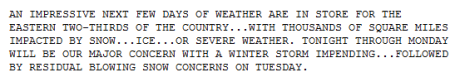
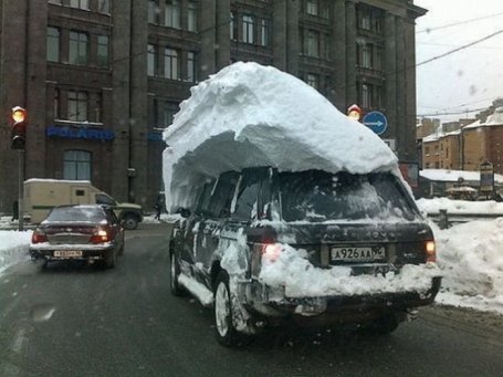
Commuter Alert. I've said it before - it may be worth repeating. 3-5" of light, powdery snow at 16-18 F. is more dangerous (from the standpoint of fender-benders) than a foot of snow at 28-30 F, when MnDOT chemicals are capable of keeping most freeways wet/slushy. With Monday and Tuesday temperatures in the teens and single digits snow will become quickly compacted into a thin layer of ice. Even though the heaviest snow bands will stay well south of MSP the air temperature is a factor, and I'm expected Hassle Factors in the 4+ range today and Tuesday morning. Leave plenty of extra time to reach your destination.
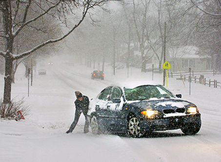
Blizzard Potential. NOAA has a special (experimental)
product capable of predicting blizzard conditions (visibility under 1/4 mile in falling/blowing snow, sustained winds over 35 mph). This graphic, valid around 7 am Wednesday morning, shows near-blizzard conditions from near St. Louis and the Quad Cities to Chicago, South Bend, Detroit and Buffalo.
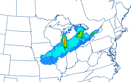
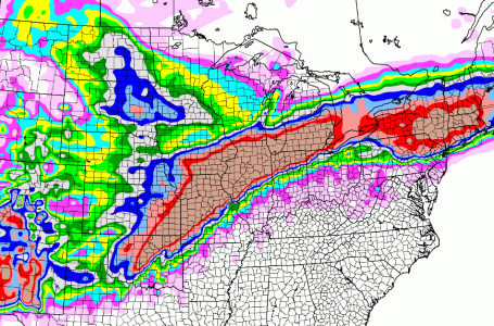
Storm Track. The models are in pretty good agreement and alignment about this week's (major) storm track. Remember, the heaviest snows usually fall 50-200 miles north/west of the track, putting the epicenter of heaviest snow from Missouri and southern Iowa into Illinois and Michigan.
Monster Storm. This is not going to be just another garden-variety snowstorm. Both the NAM model (above) and the GFS are printing out a huge swatch of extreme snowfall amounts, as much as 10-20" from Kansas City and St. Louis to Chicago, Ann Arbor, Detroit, and (by Thursday) Albany, the northern suburbs of New York City and the Boston area. Ice may down trees and power lines just south of the heavy snow band, with a severe weather outbreak for the south. in short: potentially the most widespread (and potentially damaging) winter storm in at least a decade for the USA. It seems Old Man Winter saved the worst for Ground Hog Day. Yes, we get the message...
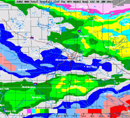
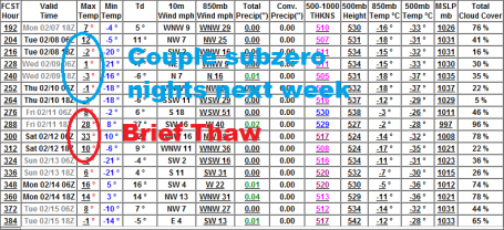
3-5-8" Models print out about .40" liquid, which would normally equate to 4" of snow, give or take. But with air temperatures in the teens the snow/rain ratio may be closer to 15/1, so amounts could easily top 6" in the south metro by Tuesday morning, maybe some 8" snowfall totals closer to Mankato and Cannon Falls. Definitely "plowable".
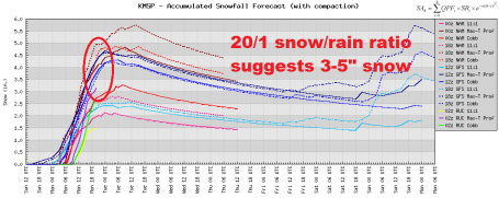
Pick a Model Run - Any Model Run. Throw out the biggest number (5.7") and the lowest number (2") and focus on the mean or median amount - closer to 3-5" by Tuesday morning, which seems a reasonable estimate.
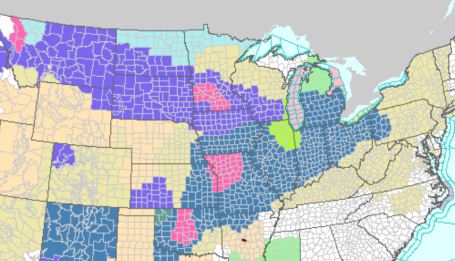
Blizzard Watch For Chicago. The heaviest snow bands should set up a few hundred miles south/east of the Twin Cities. Winter Storm Watches are posted from north Texas across the Midwest, Central Plains Ohio Valley and Great Lakes. Frankly, I can't remember a time when so many counties were under watches and warnings. That bright green splotch around Chicago is a Blizzard Watch, which will undoubtedly be upgraded to a Blizzard Warning by Tuesday. Windchill Advisories are posted for northern Minnesota, where a harsh north wind at 15-25 by Tuesday will make it feel like -30 to -40 F. For the last watches, warnings and advisories from NOAA click
here.
Temperature Roller Coaster. No sign of a sustained thaw - yet. Next week (second week of February) should start out numbing, maybe 2 nights below zero around the 8th and 9th of February, followed by a brief thaw around Saturday, the 12th. The longer a sustained thaw is pushed out and delayed later in February, the greater the risk of a sudden and sustained thaw capable of rapid snow-melt. This is another reason why meteorologists are increasingly concerned about a risk of widespread river flooding later this spring.
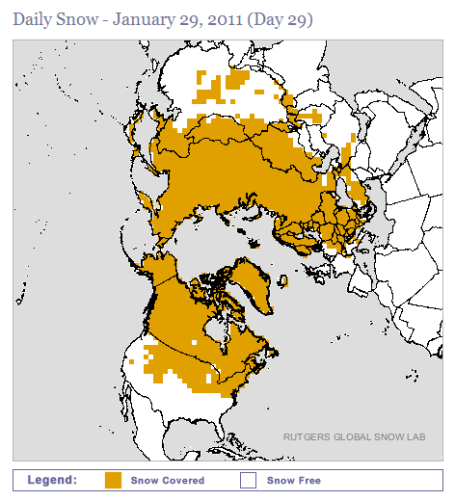
Snow On The Ground Worldwide. Rutgers has a web product that shows snow on the ground around the planet. Click
here to see the latest.
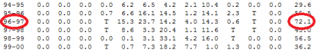
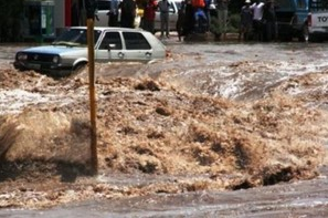
The Implications Of Heavy Snow. At the rate we're going (55.7" so far at MSP, 60"+ by Tuesday) we're on track for somewhere between 70-80" for the winter season. Everyone remembers the epic flooding during the spring of 1997, which inundated much of the Red River Valley, producing historic flooding in Fargo/Moorhead. As you can see from the graphic above 72.1" fell at MSP that winter, with considerably more in the Red River basin. I'm not saying that this level of flooding is imminent, but we have most of the conditions necessary for severe flooding: saturated ground from a wet fall, heavy snow (with a water content of 4-7" over parts of western MN). If the thaw is gradual, and we don't experience heavy rains in March, we may be OK, but I wouldn't bet on it at this point. This is why NOAA river forecasters are so concerned, looking out 40-60 days into the future.
Flood Insurance. You might be surprised (even shocked) to discover what is and is not covered by flood insurance. Now would be a good time to check your policy if you live in a flood-prone area. From the MN Dept. of Commerce
web site:
- A standard homeowner's insurance policy does not provide flood coverage.
- You cannot depend on disaster assistance. You only get assistance when the President declares a disaster. Since less than 50 percent of floods are declared disasters, most flood victims are on their own.
- Paying for flood insurance is less expensive than paying back a disaster loan. Most disaster aid comes in the form of loans, which must be paid back. The average loan payment on a $50,000 disaster loan is $240 per month ($2,880 per year) for 30 years compared to a $100,000 flood insurance premium which is about $400 per year ($33 per month).
The 7 Biggest Snowstorms Of All Time. The Mother Nature Network (who knew?) has an interesting
story about the 7 largest snowfalls ever recorded. Our upcoming 4-6" would be a rounding error compared to some of these previous storms. Here's an excerpt: "
A series of major blizzards recently hit the East Coast of the United States. In one, about 20 inches of snow fell in Central Park, 2 feet in Brooklyn, 18 inches in Boston. Some New York City subway riders were trapped in cars for more than 10 hours, and thousands of flights, buses and trains were cancelled. Even the NFL took the unusual (and unpopular) step of postponing a game in the face of the storm. These storms joins a long list of major U.S. blizzards that are as notable for their snowfall totals as they are for their disruptive reach. The biggest blizzards are the ones that shut down entire swaths of the country, the ones that close airports, shutter businesses, and keep the kids at home from school — often for days and weeks on end. Without further adieu, here are the seven biggest U.S. snowstorms in recorded history."
Forecast Calls For A Hot 2011. It's hard to imagine, hip deep in snow with a nagging wind chill blasting you in the face, but at some point the snow will melt, and summer will arrive (probably overnight). Here's a
taste of what the U.S. may experience later this year: "
Sure, the East Coast has been hit especially hard with snowstorms this winter. But be prepared. The weather forecast calls for a hot 2011. In fact, last year tied for the hottest year on record, the result of a long-term warming trend which will continue, according to the World Meteorological Organization (WMO). Whether you chalk it up to global warming or merely write it off as “natural fluctuations” in climate, you cannot deny that the first 10 years of this century were the hottest decade since we started keeping records in the 19th century. WMO Secretary-General Michel Jarraud commented at a news conference that the organization believes greenhouse gas emissions are to blame: “The main signal is that the warming trend continues and is being strengthened year after year.” “The trend, unfortunately, will continue for a number of years but the amplitude will depend on the amount of greenhouse gases released. It will depend on action taken to minimize the release of greenhouse gases.”
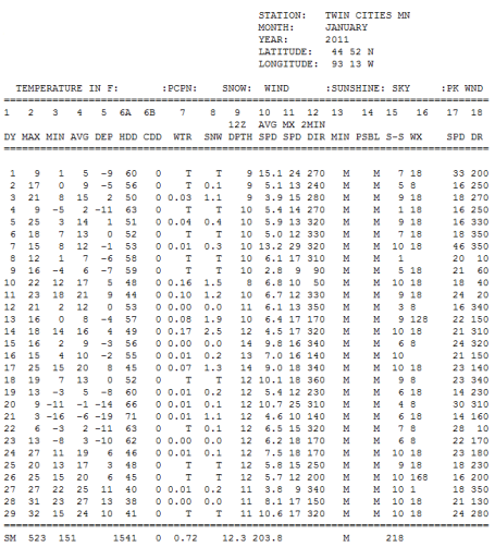
Ah, The Memories. Four days of single-digit highs, seven nights below zero, as cold as -16 back on the 21st, with 12.3" of snow (and counting). We'll probably wind up with closer to 15-16" for January in the Twin Cities, including today's snowfall. I now it SEEMED colder (with all the towering piles of snow everywhere) but, for the entire month - factoring highs and lows, January temperatures are running 1.4 degrees F. colder than average. We've seen worse. To see the data from NOAA and the MN State Climate Office for yourself click
here.
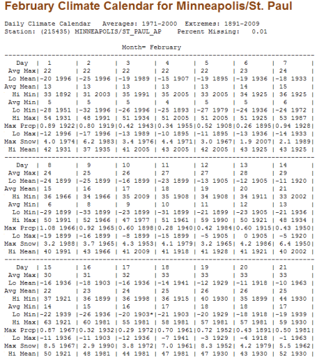
Looking Ahead. Hard to believe that February kicks off Tuesday, followed by what SHOULD be a national holiday: Ground Hog Day on Feb. 2. Look at the bright side: the average temperature has already risen 3 degrees since the second week of January (from 19 to 22 F.). By the end of February the average high reaches 29 F. Wow. Average snowfall for February is a modest 8 1/2" (less than January or March because there are 3 fewer days). Look ahead to February (or
any month for that matter) and see averages and records
here, data courtesy of the MN State Climate Office.
Endless Storms Causing "Snow Rage". Heavy snow + in-your-face New York "nice" = potential trouble, as this
story from the local Fox affiliate in New York City uncovers:
"Snow plows have been out in full force in Wayne, N.J. since the storm hit. But some people who are digging out claim, some operators are plowing them right back in. It's causing snow plow rage. Nancy Snyder's husband is a public works employee. She says an angry resident attacked him with a bucket of salt. "He sees the red face. He sees the anger in the resident. He sees the swinging bucket. And he even says, 'Roll down that window or I'm going to bust you in the head with it.' And boom," Snyder says. She says the bucket missed her husband but shattered the passenger side window and dented the door of his plow truck. Chuck D'Angelo allegedly threw the bucket. D'Angelo says, "I wasn't happy for my actions for that day. I was really annoyed at him and coming and plowing me straight in."
Prediction. What do you want to bet the groundhog does, in fact, see his shadow Tuesday morning at sunrise? Count on it. If you get a chance, rent "Groundhog Day" with Bill Murray - still one of my favorite flicks of all time.
All-Snow TV. Just imagine the possibilities. An enterprising reporter at the New York Times did just that in a
story that dreamed up a perfect prime-time line-up for snow lovers:
MIDNIGHT TO 2 A.M. College hockey: Minnesota-Duluth vs. Alaska-Anchorage.
2 A.M. TO 3 A.M. “CSI Fargo”: State-of-the-art forensic sleuthing indicates something amiss in the mangled head and left forearm sticking out of the wood chipper.
3 A.M. TO 6 A.M. “The Shining.” Movie. Jack’s excellent winter adventure.
6 A.M. TO 7 A.M. “SpongeBob SquarePants”: Tragedy strikes as Bob freezes into a brick while visiting the
New England Aquarium in Boston. Final episode.
7 A.M. TO 8 A.M. “
Live! With Regis and Kelly”: Kelly bids a nostalgic farewell to Regis by giving the ceremonial push that sets Reege rocketing down the 88-meter vertical drop of the luge run at the
Upper Peninsula Luge Club in Negaunee, Mich. Final episode.
8 A.M. TO 9 A.M. “The Suite Life of Zack and Cody”: The cruise ship hits an iceberg and sinks. Final episode.
9 A.M. TO NOON “Dead Snow.” Movie. Medical students stranded in a frozen Norwegian cabin meet chainsaw-wielding Nazis.
NOON TO 1 P.M. “Emeril Live”: Emeril prepares frozen Cajun jambalaya and blackened snowmelt from his outdoor kitchen in Devils Lake, N.D.
Paul's Conservation Minnesota Outlook for the Twin Cities and all of Minnesota:
TODAY: Winter Weather Advisory Metro area - Winter Storm Warnings far southern/western suburbs. Snow likely, roads getting worse. About 3" by evening. Winds: NE 10-15. High: 17
Monday night: Light snow continues - very slippery travel. Low: 9
TUESDAY (Feb. 1): Snow tapers, 3-5" totals, closer to 8" far southern and western suburbs. High: 13
WEDNESDAY (Groundhog Day!) : A Yukon sun, coldest day of the week? Wind chills near -25. Low: -9. High: 5
THURSDAY: Mix of clouds and sun, still numb. Low: -7. High: 15
FRIDAY: Much better - more clouds, risk of a thaw. Low: 13. High: 32
SATURDAY: Early than, then windy, turning colder with a few flurries. Low: 23. High: 33 (falling by PM hours)
SUNDAY: Few flurries, cooler again, closer to "average" for early February. Low: 22. High: 27
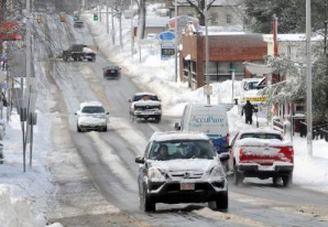
Slow-Motion Snow Event
Just when you thought our winter couldn't get any worse - or impossible for travelers. Lately air travel has become a rigged Lotto game. "Will Old Man Winter roll the dice and allow me to reach my destination?" Odds are (this week) the answer is no. A monster-storm (and I don't use that description lightly) will track across the nation, producing blizzard conditions from Kansas City to Chicago, Detroit and Boston. Some 10-20" amounts are likely, with white-out conditions and impassable roads just to our south.
Minnesota will be on the northern fringe of significant accumulation, but 3-5 inch amounts are possible in the metro - with over 8" south/west of the MSP metro by Tuesday, where Winter Storm Warnings are posted. This will be a "cold snow"; temperatures in the teens making it virtually impossible to keep roads from becoming compacted with snow and ice. Remember, 3-5" at 16 F is more dangerous than a foot at 29 F, when chemicals, salt and sand tend to keep most major roads wet and slushy.
After 2 days of (minor) Siberian pain around midweek a rapid thaw returns: 32 F likely by Friday and Saturday. But for much of America this may be the worst winter storm in 10 years.
A Physicist Explains Why Parallel Universes May Exist. I'm having enough trouble with THIS universe, but if you want to expand (or blow) your mind on a Monday, check out this
article from NPR. Here's an excerpt: "
Our universe might be really, really big — but finite. Or it might be infinitely big. Both cases, says physicist Brian Greene, are possibilities, but if the latter is true, so is another posit: There are only so many ways matter can arrange itself within that infinite universe. Eventually, matter has to repeat itself and arrange itself in similar ways. So if the universe is infinitely large, it is also home to infinite parallel universes. Does that sound confusing? Try this: Think of the universe like a deck of cards. "Now, if you shuffle that deck, there's just so many orderings that can happen," Greene says. "If you shuffle that deck enough times, the orders will have to repeat. Similarly, with an infinite universe and only a finite number of complexions of matter, the way in which matter arranges itself has to repeat."
Basket Case. India continues to come to grips with some major transformations in temperature and moisture patterns, documented in this
article from the Times of India: "
The unseasonal rain that has begun to fall on Karnataka every January and February hasn't affected coffee production very much — there's just a 5% dip in yield. But, it's entirely possible there will be discernible change in the quality of the coffee bean... and the coffee that you drink. Blame global warming? There's more. Assam, which accounts for more than half (52 per cent) of all the tea India produces , last year grew 15 million kg less than the year before. Some of the tea reportedly tasted different — much weaker than the "strong" brew that Assam is famous for. And then there is Himachal Pradesh's main crop — the apple. The fruit grows on 90,000 hectares across the state but Himachal could lose as much as 25 per cent of that, as low-lying orchards at anywhere between 4,000 and 5,500 ft start to warm up."
Get Used To The Weather... The Sunday Times of South Africa has a
report, trying to put recent extremes into perspective. Here is an excerpt: "
It's official: the weather is getting weirder. South Africa's top scientists, however, say it is too soon to confirm that global warming is behind the increasing number of droughts and floods - including countrywide floods that have now claimed at least 88 lives in the past six weeks. Floods in eight provinces have caused death and destruction, costing an estimated R2.3-billion, according to the latest report from the Department of Co-operative Governance. Heavy rains continued across much of the country on Friday. Vuyelwa Qinga from the department said damaged infrastructure included schools, roads, water treatment plants, water drainage systems, bridges, electricity poles, telephone lines and churches. By the end of the week, KwaZulu-Natal had reported 47 deaths, said Qinga. New data compiled by the South African Weather Service and released this week to the Sunday Times suggests the regional climate has already changed, becoming warmer and more extreme since detailed temperature and rainfall monitoring began in 1960."
Alaska Seeing Impact Of Climate Change In Its Infrastructure, Villages. The Fairbanks Daily-Miner has a
story documenting some of the changes being observed across central Alaska. For Alaskans it's no longer the theory of climate change. It's a reality. "
Climate change has already begun to make life difficult for state transportation managers. And they expect it to become a bigger and more expensive challenge if warming trends continue as predicted. “With over 6,600 miles of coastline and 80 percent of the state underlaid by ice-rich permafrost, you can certainly imagine we are at the forefront of climate change impacts,” said Mike Coffey, maintenance and operations chief for the Alaska Department of Transportation and Public Facilities. Coffey discussed the impact of climate change on transportation in a webinar last week, hosted by the Alaska Center for Climate Assessment and Policy at the University of Alaska Fairbanks. New challenges include warming permafrost, coastal erosion and the potential for more dramatic storms and flooding, he said. These could lead to more highways and facilities cracking, icing up or even washing away. The hardest-hit areas are northern, western and Interior Alaska, where roads and structures are built over permafrost and near the coast."
This Is Global Warming? Virginia's Sun Chronicle has a
story focusing on the disconnect many locals are feeling about weather vs. climate. How can a slowly warming world be producing more frequent and extreme snow storms? An excerpt: "
We may be bundled and buried, but scientists say the planet is still getting hotter Whatever happened to global warming? That's the question area residents might ask after last week's sub-zero temperatures and snowstorm - the latest in a series of major storms bringing the winter total for snowfall to 52.5 inches. Yet, scientists say the severe weather does not disprove global warming. In fact, it may be an indicator it is occurring. Virginia Burkett, a senior scientist with the U.S. Geological Survey, said global warming - or climate change - heats up the atmosphere and creates more energy. That results in extreme weather of all kinds, including severe cold, big snowstorms, drought and heavy rain. "It is definitely not an indication that there is not a trend toward global warming," she said. If you look at the earth's temperatures over the past 30 years, there is definitely a trend toward warming, she said. United Nations records show 2010 was tied for the hottest year in recorded history."
Is Science Political? Rawstory.com has an interesting
clip with HBO host Bill Maher, one that delves into the science. In a perfect world (it ain't) science is apolitical, transcending partisan politics. At least with climate change it hasn't exactly turned out that way. So, back to the question: is science "political"? "
That's what one guest on HBO's "Real Time with Bill Maher" claimed Friday, drawing gasps from the studio audience during a discussion about global climate change. "Science is very political," Rep. Jack Kingston (R-GA) said. "The only science that is 'political' is the science that is funded by oil companies," host Bill Maher replied. "And Democrats," Rep. Kingston then quipped. Moments prior Kingston blasted former vice president Al Gore for his Academy Award-winning documentary about climate change, "An Inconvenient Truth." But the comedian would have nothing of it. "Why isn't it a conservative position to conserve the Earth?" Maher asked to no direct reply. During the program, Kingston, who is a member of a House subcommittee on defense, maintained that the science behind climate change was inconclusive. However, the climate science community unanimously agreed that human industry directly effects the Earth's climate. "It is well established through formal attribution studies that the global warming of the past 50 years is due primarily to human-induced increases in heat-trapping gases," the US government's Global Change Research Program reported. [PDF] "Such studies have only recently been used to determine the causes of some changes in extremes at the scale of a continent. Certain aspects of observed increases in temperature extremes have been linked to human influences."


No comments:
Post a Comment