55.7" snow this season at MSP.
Trace of snow fell Saturday.
1-2" possible by Monday AM rush hour.
3-6" possible by Tuesday morning.
10" on the ground in the Twin Cities.
52 number of years I've been on planet Earth.
26 number of winters I've spent in Minnesota.
1190 Paul's SAT score back in 1979 (no, I'm not especially proud of that one).
10 number of on-air meteorologists at WeatherNation.
54 number of minutes of daylight since December 21 (by the end of January).
55 number of days until the spring equinox.
34 number of days until "meteorological spring" (the real start of spring is March 1, as far as the atmosphere is concerned). Historically the 90 coldest days of the year run from roughly December 1 through February 28.
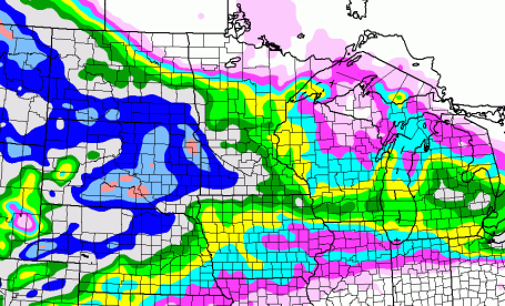
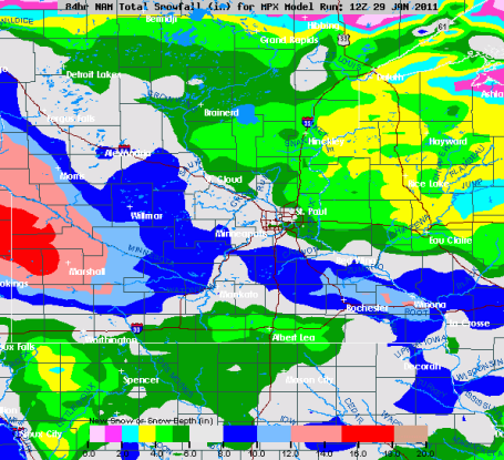
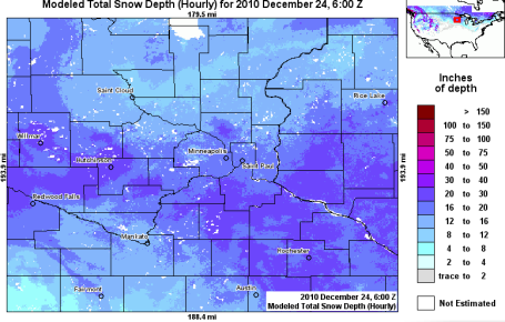
How Much? The NAM model is printing out 3-6" for the metro, with the greatest amounts south and west of Minneapolis, a long-lasting snow event starting Sunday evening, with light snow spilling over into Monday, possibly Tuesday morning.
Metro Close-Up. With a temperature close to 20 much of Monday, a snow ratio of 15:1 is possible, and a very real possibility of some 3-6" amounts in the metro. Models are suggesting more than 8-10" south/west of Willmar and Morris.
Take Your Pick. There's still a fairly wide spread in predicted amounts from over a dozen different weather models (each running slightly different physics and initiatlization schemes). A good midrange amount would be 4-5", enough to shovel and plow.
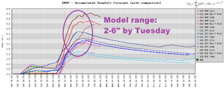
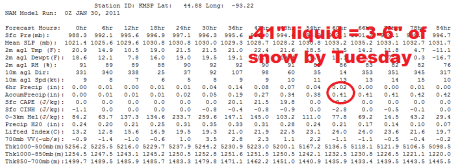 Latest NAM Model
. The 00z Saturday night run prints out .41" by late Monday night/Tuesday morning - 3 runs/row around .4 to .5". Could we still see less? Absolutely. But I'm not sure how we see anything less than 1-2" Monday. Upper end: 5-6", most likely southern and southwestern suburbs by Tuesday morning.
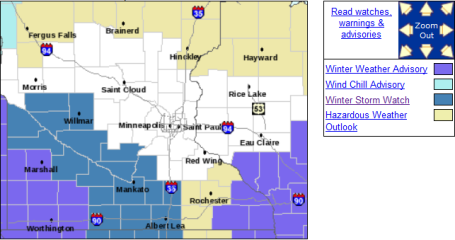 Winter Storm Watch
. The local NWS has issued a storm watch for much of southwestern Minnesota for a much as 6" of accumulation Monday and early Tuesday. The immediate metro area is not in the watch area - but I expect advisories to be issued, the watch possibly extended into MSP by Sunday PM. More details
here.
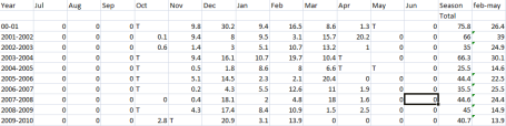
How Much Snow After February 1? I asked Pete Boulay, at the MN State Climate Office, and he spent me this spread sheet, showing the last 10 years. The magic number (averaging the most recent 10 years): 23.6" from Feb. 1 through the end of the snow season in April. Before you stick your finger down your throat - remember that snow falling in March and April melts (almost instantly) - very different from snow in January and early February. By Tuesday we'll probably have close to 60" for the winter so far. At this rate we may easily see an 80" winter.
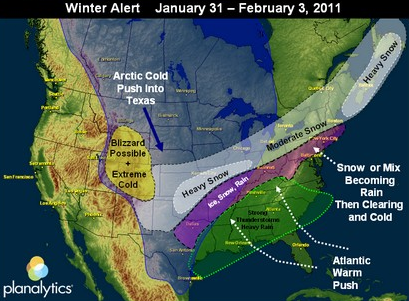
A More Active Week. The meteorologists at Planalytics, outside Philadelphia, are predicting another series of significant storms from the Upper Midwest and central plains into the northeast, as the next surge of Canadian air interacts with warmth and moisture from the Gulf of Mexico and Atlantic.
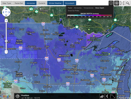
Interactive Snow Amounts. Ham Weather, a division of WeatherNation that focuses on data, maps and interactivity, has a
new map that shows how much snow is on the ground. You can also call up radar, different satellite images, and the probability of snow 3 days into the future.
Metro Snow. I find it (vaguely) interesting that the heaviest snow has fallen over the south metro, where a cool 20-30" is on the ground, with lesser amounts north of MSP and St. Cloud. See for yourself
here, courtesy of NOAA's Interactive Snow Information tool.
MSP Meteogram. Click any zip code into
this site and you'll get a forecast for the next 12 days (highs and lows). The Ham Weather calculator also superimposes the "normal" highs and lows over the predicted data, to better put things into perspective. Note that the average high rises from 21 on January 29 to 23 by Feb. 11. Progress?
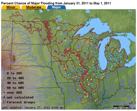
Growing Flood Threat.
Here is the latest from NOAA's North Central River Flood Forecast Center, showing a greater than 80% of flooding on the Red, Minnesota and Mississippi Rivers through early May. With more snow in the forecast, as much as 6" of liquid water trapped in the snow pack near Montevideo - and the prospect of a rapid thaw in late February and early March, I suspect river flooding in late March/April may be worse than anything we've seen in recent years. The primary factor: this could wind up being the snowiest winter since 1992. Depending on how much rain falls in March, we could be facing some of the worst flooding conditions since 1997 on many of Minnesota's rivers. I want to emphasize that I am NOT a flood forecaster. I have immense respect for NOAA's team of hydrologists focused on the upcoming flood risk; they do an amazing job. But just looking at the meteorological ingredients necessary for major flooding - we have all of them. Factors that can't be predicted: 1). How quickly we thaw out, and 2). Whether the coming thaw will be accompanied by frequent/heavy rains, which would accelerate snow melt and make a bad situation much worse. People that live in flood-prone areas should check their insurance policies and get serious about creating a plan, should conditions go downhill in 45-60 days. We'll know more by mid February - but right now I do not have a good feeling about the potential for major, widespread flooding. I think it's all but inevitable.
. Renee Schoof from the McClatchy Newspaper Company delves into the sheer quantity of snow in the east, and how a "real winter" is muddying the
message that more frequent and intense snowfalls may be yet another symptom of a warmer, wetter atmosphere:
"
Tree limbs snap, the power goes out, the car needs digging out again. Along with the grumbling about winter snow there's also a common curiosity: So what does all this say about global warming? How can the average world temperature be inching up and 2010 be tied for the warmest year ever, when places from North Carolina to New England get buried by whopper winter storms? There are several scientific explanations that help sweep away the snow confusion. But like everything else related to climate science, it's all rather muffled these days, at least in the nation's capital. Those who don't accept climate science are vocal. Some of those who do accept it think it's better to talk about jobs or technology, rather than what's going on with warming oceans and atmosphere."
How Bad Is The Snow? Depends Where You Live. The New York Times points out the different responses to the snowiest January on record for the Big Apple: there is Manhattan, and then there's everything else. The
article explains: "
The difference between Manhattan and the rest of the city is so ingrained in the local psyche that residents of the other four boroughs are more likely to take pride in, rather than offense at, the notion that they live in a different New York City. But rarely have those two New Yorks felt more different than in the last 34 days. New Yorkers in Manhattan have mostly had their building superintendent shovel out their stoops and sidewalks. New Yorkers in Bayside, Queens, have had to do it themselves, using shovels and another tool foreign to apartment-dwellers in Manhattan: electric or gas-powered snow blowers. New Yorkers in Manhattan walked to the subway, which ran smoothly for the most part there, or took a cab. New Yorkers in Flatlands, Brooklyn, or in nearby Mill Basin — where the closest subway is two miles away on some blocks — shoveled the stoop, and then the sidewalk, and then the driveway out back that leads to the garage. New Yorkers in Manhattan were often late for work. New Yorkers elsewhere had to burn vacation days."
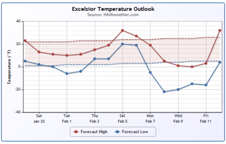
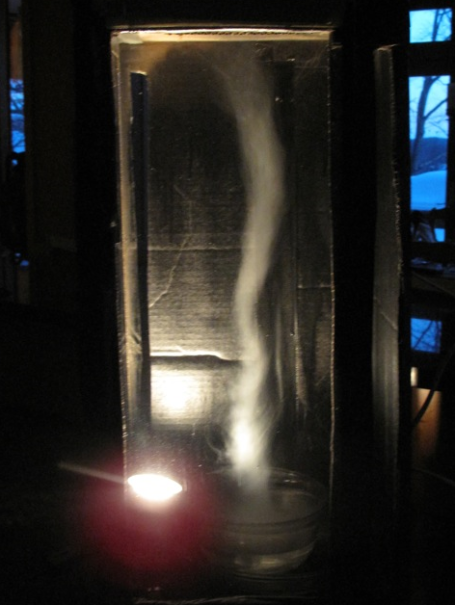
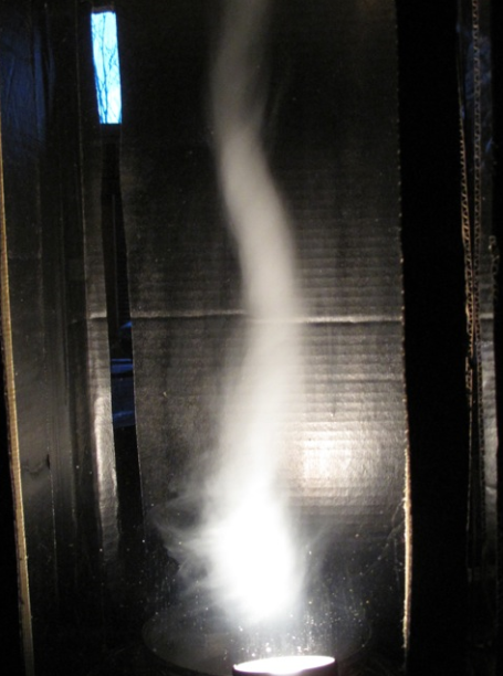
Tornado In A Box. This "tornado simulator" was constructed by Landon and Payton Frostad for the Imagination Fair at the Excelsior Elementary School (with a little help from their father - my friend and business partner, Todd Frostad). It's really quite extraordinary, powered by a fan at the top, and dry ice to create the visible funnel vortex. If you have the time, the (basic) materials and the desire, you can build your own tornado simulator, maybe score some points for your kid's next science fair? The specs can be found
here.
 Saturday Statistics
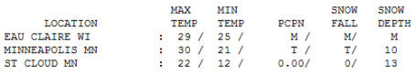
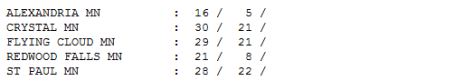
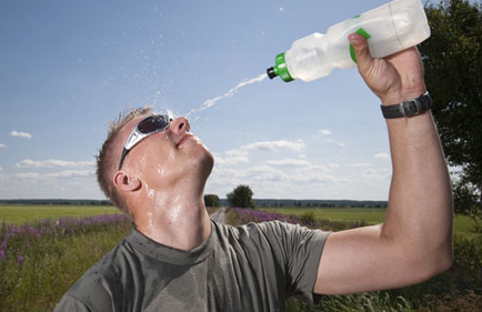
. Yesterday's high was 32 (around midnight) falling through the 20s during the day with a trace of snow. Highs ranged from 16 at Alexandria to 22 in St. Cloud.
 Paul's Conservation Minnesota Outlook for the Twin Cities and all of Minnesota:
TODAY
Paul's Conservation Minnesota Outlook for the Twin Cities and all of Minnesota:
TODAY: Cloudy, flurries possible by late afternoon. Winds:
N 7-12. High:
near 20
SUNDAY NIGHT: Light snow likely, 1-2" possible by daybreak Monday. Low: 12
MONDAY: Light snow, 3-5" possible by Monday night. Icy roads - worst travel day of the week. High: 22
TUESDAY: Snow taper to flurries. Colder. Low: -2. High: 8
WEDNESDAY: Numbing sunlight, parka weather returns. Low: -9. High: 9
THURSDAY: Sun gives way to more clouds. Low: -5. High: 11
FRIDAY: Mostly cloudy, "average" again. Low: 6. High: 23
SATURDAY: Flurries, risk of a thaw. High: 31
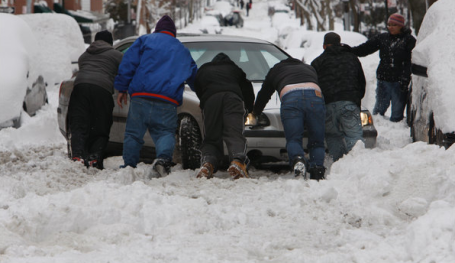
Potentially "Plowable"
Here we go again. It's been 2 weeks since we've seen enough snow to foul up our commutes (4.4" fell January 13-14). The next, slow-moving storm sparks a long-lasting snow event from tonight through Tuesday morning. As much as .45" liquid water (at 20 F) may translate into 3-5" snow, most of it coming Monday.
Yes, the natives are a bit restless. Adam Platt, Executive Editor at Mpls. St. Paul Magazine put our winter into stark perspective. "It's taken me 29.5 winters of living here, but I've finally figured out why, no matter how many inches of snow NYC or DC or BOS or CHI get above what we get in a winter, it's still inconsequential. Their snow MELTS. Ours doesn't. Here, it just piles and piles for about 90 days." Good point.
I checked with Pete Boulay at the MN Climate Office. He confirmed, "37 hours above freezing since December 1, all in December." For 3 hours early Saturday we experienced 32 F. Some January thaw.
The sheer quantity of snow, coupled with the lack of any melting, has me increasingly concerned about river flooding by March. Hope I'm wrong. Monday snow will be followed by a cold week (3 nights below zero) - but 32 F returns next weekend. What a winter.
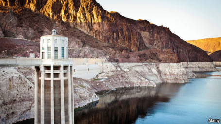
That Sinking Feeling - Long Term Climate Trends In The West. The Economist examines long-term trends in the west, predicting Las Vegas is the "canary in the coal mine" - the American city most at risk of major disruptions to its water supply. An excerpt from the
article: "
STANDING on the Hoover Dam and looking upstream at Lake Mead, America’s largest reservoir, the visitor notices a wide, white band ringing the cliffs. Nicknamed “the bathtub ring”, this discolouration comes from minerals that were once deposited on the volcanic rock by the Colorado River and have become visible as its level has dropped. It is one sign of a water crisis that threatens America’s south-west. Other reminders abound. Farther upstream there are dry docks, jutting out ominously into desert, where boats were once moored. In one finger of Lake Mead buildings that were abandoned in the 1930s, as the water of the newly dammed river rose and submerged them, have eerily begun reappearing, like a ghost town. The main reason why Lake Mead, currently only 40% full, has been getting emptier is a decade-long drought. Whether this is a cyclical and normal event, or an early sign of climate change, is unclear. But even if the drought ends, most scientists think global warming will cause flows on the Colorado River to decrease by 10-30% in the next half century, says Douglas Kenney, the director of a water-policy programme at the University of Colorado Law School."
 Two Cold Winters Don't Make A Climate Trend.
 NPR's Ira Flatow had a recent
interview with John Wallace, an atmospheric scientist at the University of Washington in Seattle. Here is an excerpt: "
Are we talking about global warming here, or is it too nebulous to say that?
Dr. WALLACE: Yes, well, I would never associate an event in as short a period of time as a single winter, or even a single couple of years, with global warming, which is a very slow process that's really evolving on the timescale of decades and longer.
FLATOW: So why is it much warmer in the Arctic at this point?
Dr. WALLACE: Right, well, we've had a particular circulation pattern this winter that was really most evident from about mid-December to mid-January, where we had the jet stream that normally comes more or less straight across North America and goes out into the Atlantic, just about over New York, towards England.
And it's usually strong and forms a strong barrier that keeps the cold air to the north and the warm air to the south, but it got distorted in such a way that the cold air was coming down into the eastern United States. And then we had some of the warm air deflected up into Greenland and eastern Canada, and this set up the conditions that are favorable for that cold and snowstorms in the East Coast.
FLATOW: Now, didn't that sort of thing happen last year, also?
Dr. WALLACE: It did, yes, and we recognize it as a recurrent pattern that we can identify in past years, going back even a century. And we can keep track of how often it happens from one decade to another, as well."
Obama's Clean Energy Challenge. Analyst Kent Moors has an interesting
post in Seeking Alpha (geared to investors), a review of President Obama's State of the Union Speech, with an emphasis on green, sustainable energy by 2035. A good idea? "
On balance, most people think so. After all, renewable and alternative energy sources would allow us to emphasize what the U.S. does best – innovation and new departures in technology. It does create some dislocation in those economic sectors that depend upon crude oil and coal – the primary targets of such a move (although clean coal technology is already becoming an alternative discussed at length in Pennsylvania, West Virginia, Ohio, and other states where King Coal still holds considerable sway). Nonetheless – and this will be the focus of debate on this initial question – the move to a preponderance of clean energy sources will create economic problems in areas where oil and coal are produced. The social and policy calculus can hardly leave that out of the mix. In short, there will be considerable politics played here, for the overriding reason I drum into my graduate students at the beginning of their education:
There are no public decisions made that do not hurt somebody.
That is what the balancing of interests inside the Beltway or in the corridors of a statehouse are all about. The great Speaker of the House Sam Rayburn said it most colorfully: "It all depends on whose ox is getting gored."
Heat-Related Deaths Could Jump. An
article from Chemical and Engineering News:
"Heat is the leading weather-related killer, ending more lives than do hurricanes, floods, tornadoes, and lightning combined. Experts agree that climate change will boost the number of these deaths, but predicting how many people will die has been challenging. Now researchers at the Environmental Protection Agency have simulated the future health effects of rising temperatures and found that heat-related deaths in the U.S. could increase greatly in the next few decades, with estimates ranging from 3,500 to 27,000 additional deaths per year (Environ. Sci. Technol., DOI: 10.1021/es102820y)."
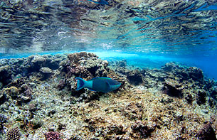
Testing The Waters. Photo above: Parts of the Great Barrier Reef have undergone an aesthetic decline, reflecting the dangers from global warming that the vast, fragile ecosystem faces. An excerpt from the Time
article:
"
The Great Barrier Reef is one of the world's natural wonders, covering an area larger than Italy and drawing nearly 2 million tourists every year to boat, swim, snorkel and dive amid its elaborate flora and fauna. It generates some $6 billion in revenue for Australia annually and provides employment to more than 50,000 people. It's also one of the planet's most fragile ecosystems, home to more than 11,000 species that live, if not necessarily in harmony, in a carefully orchestrated symbiotic balance. At the foundation of this giant ecological and commercial enterprise is one tiny marine organism: the coral. That foundation is no longer solid. Corals build colonies that secrete calcium carbonate to form ocean reefs. When they're healthy, coral reefs provide shelter and food for animals all along the food chain, including the top: us. Across the planet, half a billion people rely, directly and indirectly, on corals for their living. That's why what happens to the 9,000-year-old Great Barrier Reef, as well as to other reefs worldwide, is critical."

No comments:
Post a Comment