Weather Headlines:
*
Another 1 to 1.5" of snow today, totals from this long-lasting light snow event in the 2-3" range for most towns and suburbs.
* Good travel conditions Wednesday and most of Thursday.
*
Another inch of snow possible from a Friday clipper, paving the way for much colder weather by the weekend.
*
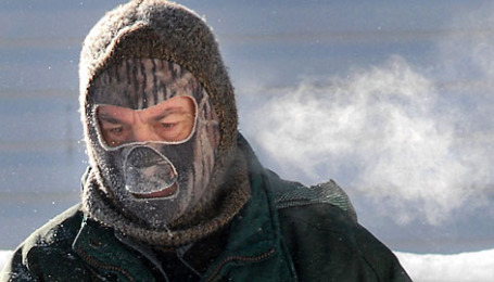
Highs may not climb above zero Sunday and next Monday, even in the metro area. Lows in the -8 to -15 range possible.
*
Arctic cold wave will be relatively brief - long range guidance hinting at a significant thaw for Minnesota after January 24,
the last week of January may bring a streak of 30s, even a 40-degree high. It may even be warm enough for rain.
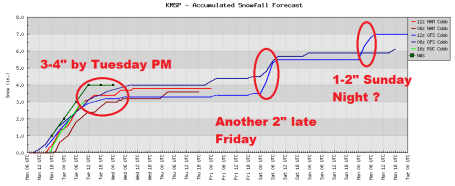
A Parade of (Minor) Snow Events. Models are all showing a series of (relatively minor) snow events brushing Minnesota, 2-4" by tonight, another 1-3" possible late Friday, maybe another 1-2" Sunday night. Arctic air is spilling south of the border in waves, each surge of bitter air preceded by a "burst" of snow.
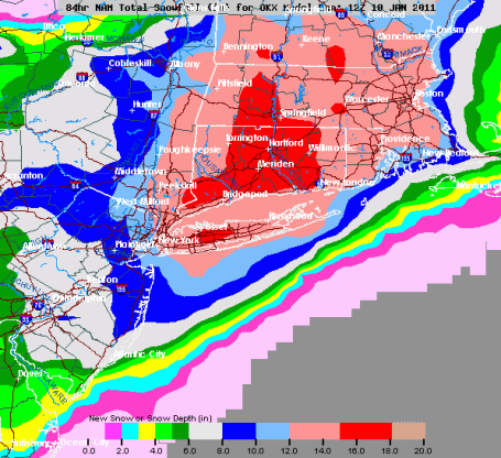
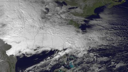
The Big (Snow-Swamped) Apple. New York City is bracing for another major storm - snow expected to develop Tuesday night, the storm will probably peak Wednesday morning before tapering to flurries late Wednesday. As much as 10-12" may fall on Central Park, with closer to 15"+ for much of Connecticut. Providence and Boston are both expecting nearly a foot of snow.
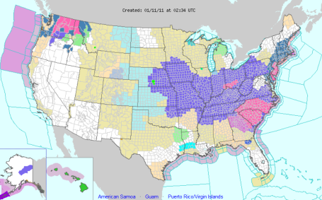
Latest Watches and Warnings. Check out the wide swath of the USA under some sort of advisory, watch or warning. Click
here to see the latest watches/warnings/advisories from NOAA.
Another Snowstorm Barrels Down On New York And Boston. Reuters
reports on the preparations in the northeast for today's storm - the brunt of the snow expected to fall Tuesday night into Wednesday. Yes, New York's Mayor Bloomberg is about to get a do-over.
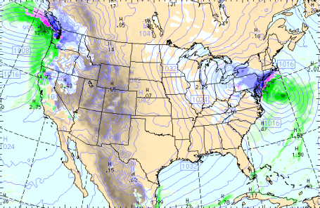
Classic Nor'easter. Click
here to see the latest WRF model run for the nation (initialized by the GFS), showing our snow tapering today, while the same storm that dumped heavy snow/ice on much of the south yesterday receives an added jolt of moisture and energy from the Midwest clipper to spin up an impressive storm on the east coast. The map above is valid at 1 am Wednesday morning, when snow intensities should be peaking from Philadelphia to New York and Hartford.
Half A Foot Fell On Atlanta. As much as 4-6" snow fell on Atlanta Monday - Delta was forced to
cancel 1,450 flights yesterday, about 25% of their schedule, because of snow at Atlanta Hartsfield Airport. A friend in Huntsville reported 8" - I even saw as much as 1/2" of snow on the Florida panhandle, near Tallahassee!
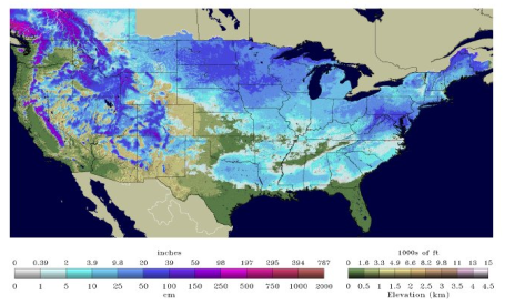
America The Beautiful (and Snow-Covered). At last report 62% of America had snow on the ground. At the peak of winter last year 68% of the lower 48 states were covered by at least an inch or more of snow. To see the latest snow depth map for the USA click
here, data courtesy of NOAA's National Snow Analyses.
National Weather Service Experimental Use of Extreme Cold Warnings. Don't be surprised if you see the local NWS office implement
this early next week, when MSP may "enjoy" a few days below zero, nighttime lows dipping into double digits. This next cold wave doesn't look nearly as forbidding as it did a few days ago, but it will still get your attention.
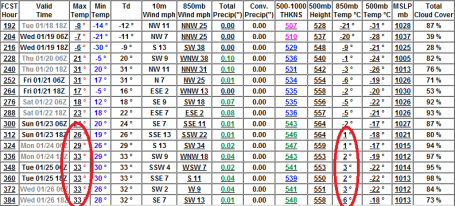
Major Shift In The Pattern? It's too early to celebrate, but I'm seeing some early guidance suggesting a major change in the pattern by the 4th week of January, after the 22nd or 23rd of the month. After a couple bitter days early next week (subzero highs are possible, even in the metro area) the GFS model warms us up into the 30s by Tuesday, January 25. In fact 850 mb temperatures (around 3,500 feet) are projected to be above freezing by then,
potentially warm enough for a little light rain the 4th week of January. Now that's a turn-around! I want to see a few more model runs to see if there is any continuity in this outlook (so far I've seen 2 GFS runs/row hinting at a thaw within 2 weeks -
it's the first real sign of hope I've seen yet.
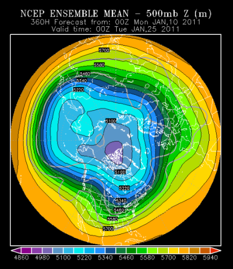
A Breath of Fresh (Pacific) Air? Here is an "ensemble" forecast looking out a whopping 360 hours, showing 500 mb winds (about 18,000 feet above the ground). Think of an ensemble forecast as an average of multiple models. The forecast for Monday evening, January 24, shows winds blowing from Vancouver and Seattle (instead of the Yukon), with Arctic air retreating well northward into Canada. Brutally cold air has been prevalent over the lower 48 states since the second week of December - it's exceedingly rare to go an entire winter with bitter cold east of the Rockies. A thaw in late January makes sense, historically and climatologically. Again, I'm hopeful, but I want to see if this is a true trend, or a computational hiccup/fluke.
"Flight Aware".
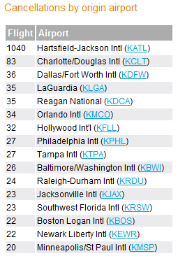
Here's a handy site (flightaware.com) that shows (in real time) which airports around the USA (and the world) are reporting cancellations. Tuesday 1,040 flights had to be cancelled at Atlanta's Harsfield-Jackson International Airport - compared with 20 cancellations at MSP in the Twin Cities.
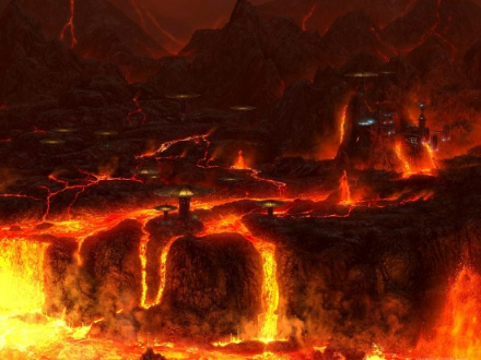
Showers of Scalding Lava? These days a lava shower sounds like a pretty good option. Geekosystem.com has an intriguing
article that explains what Earth may have endured for millions of years: "
Rising rock vapor would see its magnesium oxide start to condense into droplets and fall back onto the planet’s surface. The iron oxide inside the rock vapor wouldn’t have condensed as easily, meaning far more of it got mixed into the disc that became the Moon. This means that, for millions of years, unimaginably hot molten rock fell from the sky onto the infant Earth, and this was about as regular an occurrence as a rainstorm today."
Dead Birds Falling From The Sky - Mystery Solved? Some
press reports are now attributing the mass bird deaths in Italy to "overeating", the birds gorging on sunflower seeds? Sounds a little lame to me, but like everyone else, I'm keeping an open mind on this (vaguely troubling) story.
CES 2011: Merging TV And The Internet. The New York Times has a good (video)
overview of what your future Internet-enabled TV may look like (and be able to do). "
At this year's Consumer Electronics Show in Las Vegas, numerous companies are showing off the newest technologies that merge television sets with the power of the Internet."
Verizon To Announce iPhone 4 Today? It's still
speculative, but when I was in Las Vegas for the CES 2011 Show I heard a rumor that Apple had cancelled vacations for all employees around Feb. 9. One possibility: that will be the launch date for iPhones on Verizon's network. Stay tuned.
Eye-Catching Products In A Hall of Gadgetry. More
highlights (and lowlights) from the CES Show. From the rise of Android, to the (increasingly attractive) prospects for 3-D, to a mind-blurring devices to "improve your life" (or make sure you are connected, 24/7, whether you like it or not.
 The Ultimate Laptop For Multitaskers? Geek Alert
: Engadget has a
write-up (and video) highlighting the new Acer Iconia, complete with 2 screens. This thing is a beast! "
Acer's dual-screen Iconia laptop is bold, for sure -- eschewing a physical keyboard for another display -- but its LCD panels are also mighty glossy. If you've got a light in the vicinity above you, there's gonna be glare -- we saw it on stage, and we just saw it now in person. That said, the screen is clear and the touch functionality is pretty clever (five fingers open up a widget where you can scroll through other touch-friendly apps)." A second verdict from CNET
here.
15 Ridiculously Tough Questions From Top Employers Like Google, Goldman Sachs. A thought-provoking
story from Huffington Post and glassdoor.com: "
As tough as the job market has been in 2010, many top-flight employers aren't trying to make the interview process any easier. With the jobless claims at their lowest level in more than two years, job seekers, encouraged by the prospect of an improving economy, are dusting off their interviewing skills for the new year. Job site Glassdoor.com has sifted through 80,000 interview questions shared by job seekers providing us with some of the most odd and difficult questions asked by top-flight employers this year. Think you're smart enough to work at Goldman Sachs or Google? Check out the questions to see just how far out the box employers are expecting their interviewees to think. Which questions are expected and which are just too odd?"
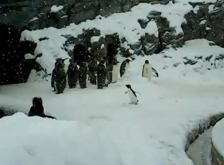
Heavy Metal Penguin. Because I had entirely too much free time on my hands Monday. Click
here - you'll never picture heavy metal quite the same way again.
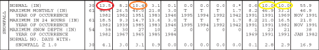
Snowfall Stats. Yes, you can prove anything with statistics, as my Dad used to remark. January is now the snowiest month of the year in the cities (13.5" on average). March is #2 now, with an average 10.4", followed by November and December, tied for 3rd place, with 10" both months. Yes, May brings an average of .1"/month. Sorry for throwing that in - just trying to be fair and balanced. For a much more legible view of this pdf, click
here to see the raw data (averages for rain, temperatures, snowfall, fog, the works), courtesy of the MN State Climate Office. Weather geeks rejoice!
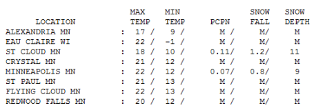
Another Inch on Monday. Officially .8" snow fell at MSP Monday, 1.2" at St. Cloud (which now has more snow on the ground than the Twin Cities - less rain/melting last week). Highs ranged from 17 at Alexandria to 18 at St. Cloud, 22 in the cities.
Paul's Conservation Minnesota Outlook for the Twin Cities and all of Minnesota:
TODAY: Light snow tapers, another 1" or so - totals from this latest snow event: 2-4" Winds: N 7-12. High: 23
TUESDAY NIGHT: Flurries wind down - improving travel conditions. Low: 9
WEDNESDAY: Clouds linger, better travel statewide. High: 16
THURSDAY: More clouds than sun, quiet. Low: -2. High: 14
FRIDAY: PM light snow from next clipper, couple inches? High: 16
SATURDAY: Drier for metro, snow possible far southwest. High: 12
SUNDAY: Another clipper, 1-2" powder late? Low: -5. High: 4
MONDAY: Some sun, much colder. Low: -11. High: near 0
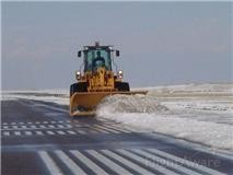
Art of Snow Removal
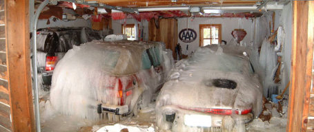
Minnesota has perfected the fine art of snow removal. So much so that, years ago, Denmark, Norway and Sweden visited MSP International for tips and pointers on how to keep an airport running when big flakes are flying. A source told me the U.S. military may have contracted with Delta to tap their deicing system.
They could use some of that expertise in Atlanta, where 4-6" snow/ice just fell.That's a problem, considering ATL Hartsfield has two (2!) deicing systems, and the city has an estimated 11 plows. Up to 8" fell on Huntsville, with a half inch reported in Tallahassee, Florida! Today the focus shifts to the northeast; half a foot for D.C. and Philadelphia, but New York and Boston may pick up a foot of new snow by Wednesday night. Kind of puts things into perspective.
Snow slowly tapers off today, a total of 2-4" in most towns, but 6" south/west of Mankato. Arctic air spilling south of the border sweeps into Minnesota in "waves", each successively colder swipe preceded by a burst of powder. Another 1-3" falls late Friday, maybe a fresh 1-2" Sunday.
Good news: next week's cold wave doesn't look nearly as bad, maybe 1-3 days below zero. Only a Minnesota meteorologist could write a sentence like that. "Only 1-3 days below zero - hey, that's not so bad!" Long-range models are hinting at 40 F. (and rain!) by the 26th. We're due for a temperature turnaround. Soon.
Famous Minnesota Winter Storms. A
list, in chronological order, from the Minnesota State Climatology Office. Here's a sample entry: "
Mar 14-16, 1870 blizzard struck northern Iowa and SW Minnesota with up to 16 inches of snowfall. First use of the term "blizzard" (from boxing, meaning volley of punches) by the Esterville, IA Vindacator newspaper. The term blizzard was not used by the U.S. Signal Corps Weather Service until 1876."
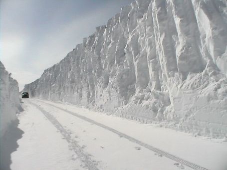
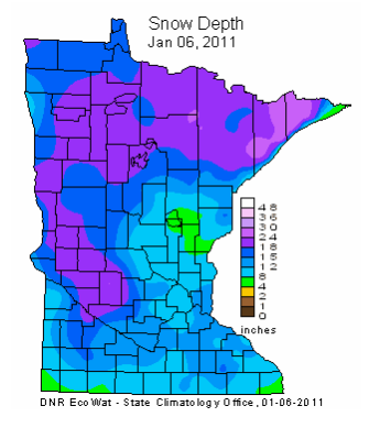
How Much On The Ground? According to the DNR far western and northern Minnesota has the most snow on the ground, at least as of January 6: as much as 18-24", with the heaviest amounts near Lutsen and the BWCA. From Mille Lacs to Hinckley only 4-8", much of the metro area has 8-12" on the ground. Click
here for more information.
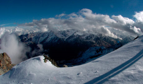
Glacier Shrinkage Will Hit Alps Hardest, Study Claims. Here is an excerpt from a recent
article at the U.K.'s Guardian newspaper: "
Glaciers in the European Alps could shrink by 75% by the end of the century, according to new research into the expected impact of global warming. The study, published in the journal Nature: Geoscience, concludes that, globally, mountain glaciers and ice caps are projected to lose 15-27% of their volume by 2100, although the extent of the damage varies widely. The analysis suggests glaciers in the Alps and New Zealand will shrink by more than 70% but shrinkage is predicted to reach about 10% in Greenland and high-mountain Asia. Climate Change Reveals Disease As National Security Threat."
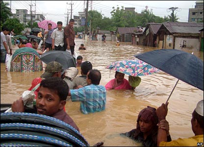
Climate-Induced Mayhem Likely To Start In Bangladesh. An ominous
story from the Miami Herald. Here is an excerpt: "
Nowhere is the potential threat from climate change more worrisome than in Bangladesh, a country strategically sandwiched between rising superpowers China and India, and which also acts as a bridge between South Asia and Southeast Asia. Already, Bangladesh is beset by extreme poverty, overcrowding and flooding that frequently renders large numbers of people homeless. The country's Muslim majority is the target of Islamist radicalization. Over the next two generations, those problems are likely to grow worse if climate change, as predicted, raises sea levels and temperatures. By 2050, rising oceans are projected to cost the low-lying country 17 to 20 percent of its land mass. That in turn is expected to render at least 20 million people homeless and decimate food production of rice and wheat, according to the United Nations Intergovernmental Panel on Climate Change. The potential for internal unrest to spill into neighboring India is great. "That is a frightening scenario," said Maj. Gen. A.N.M. Muniruzzaman, a retired Bangladeshi military officer who heads a research center called the Bangladesh Institute of Peace and Security Studies. "Given the complications of conflict relations in South Asia, any destabilization of a regional border can have very severe consequences."
Climate Changes Reveals Disease As National Security Threat. From a recent
story at the Kansas City Star: "
One of the most worrisome national security threats of climate change is the spread of disease, among both people and animals, U.S. intelligence and health officials say. But more than a decade after such concerns were first raised by U.S. intelligence agencies, significant gaps remain in the health surveillance and response network - not just in developing nations, but in the United States as well, according to those officials and a review of federal documents and reports. And those gaps, they say, undermine the ability of the U.S. and world health officials to respond to disease outbreaks before they become national security threats."


I actually have a question. The humidity in the winter seems to be higher more often, but my skin and nose are so dry all of the time.
ReplyDeleteWhy is this so?