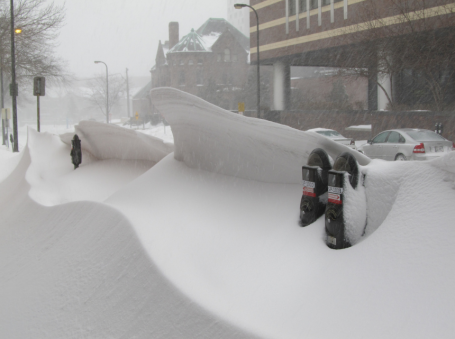
74.9" snowfall in the Twin Cities up until February 22.
40.5" normal snowfall as of February 22.
40.6" snow as of February 22, 2010.
15" snow on the ground.
MSP has seen more snow this winter than Duluth and International Falls. Really.
.9" amount of additional snow we need to pick up to be experiencing the snowiest winter since 1992.
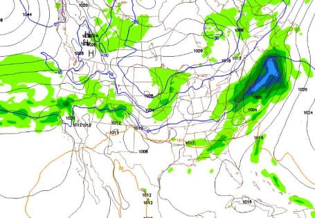
"Very high potential for widespread major flooding in Minnesota, North Dakota, and South Dakota." (NOAA)
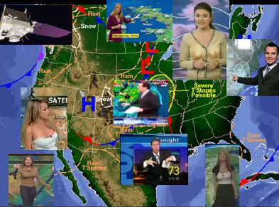
 Weather Highlights
: today will bring a welcome (but fleeting) thaw, highs reaching the mid 30s as south winds return, along with a few showers of rain and wet snow. An inch or two of slushy snow may fall on Brainerd and Duluth - just wet roads for the metro today, the mildest day shaping up for at least the next 10 days to two weeks. And that's a problem (as I'll get to later). We cool off Thursday, the next, weak, clipper-like system capable of an inch or two of powdery snow Friday and Saturday, highs stuck in the teens to low 20s. Whereas today roads will be wet, I could see some icy problems returning Friday PM into a portion of Saturday as a weak storm passes south of Minnesota. Highs return to the 20s Sunday, another shot at 30 by Tuesday of next week.
Growing Paranoia. The normal high by March 1 is 34 F in the Twin Cities, but no consistent spells of mild (above freezing) weather are in sight through March 10-15. This delayed thaw may increase the potential for flooding down the road. In a perfect world (it ain't) we'd be experiencing more frequest thaws, a couple days/row above 32 F, gradually melting some snow in the process. The fact that we're not going to melt much snow for the next 2 weeks means that when the warm air does arrive, the melting will be swift, and possibly dramatic, especially if accompanied by steady/heavy rain. Don't mean to be melodramatic here - but for every day we spend below 32 F it will make the inevitable meltdown more rapid, flooding potentially more severe.
I'm not a flood forecaster, I rely on the professional NWS hydrologists (river forecasters) for flood projections - another VERY good reason not to cut their budget by 30% and just hope for the best. I have an increasingly bad feeling about the prospects for major flooding in 30-50 days. Hope I'm very, very mistaken on this score. Just want to cover the bases. If you live in a flood-prone area check your insurance policy and create a plan for your family. If we go from 20s to 40s and 50s, virtually overnight, as we do many springs - we could wind up with some of the worst flooding on Minnesota's rivers since 1997. I don't think it'll be another 1965, but I do believe it will be worse than anything we've experienced in roughly a decade, based on the volume of snow, the amount of water locked in that snow, and the risk of a very rapid thaw. Stay tuned...
Snowfall So Far This Winter:
Twin Cities:
74.9"
International Falls:
74.8"
Duluth:
74.8"
(Thanks to weather enthusiast Ken Rosen for pointing out the fact that MSP has seen more snow so far this winter than both northern cities - checking to see if this has ever happened before in modern-day records Wow!)
Record-Breaking February Snowfall in the Twin Cities. The Star Tribune has a great
photo gallery highlighting some of the more improbably shots taken at the height of Monday's storm. Amazing but true.
#1). 13.4" February 20-21, 2011
#2). 12.4" February 1-3, 2004
#3). 10.5" February 19-20, 1952
#4). 8.8" February 22, 1913
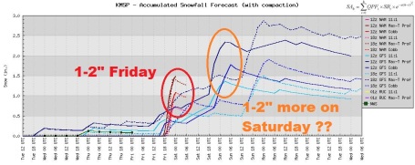
Friday Accumulation? Models are hinting at a couple inches of snow late Friday and Friday night as a weak clipper-like system pushes across the Upper Midwest. Yes, by the weekend we may have 76-77" in the Twin Cities. An impressive number, and bound to get bigger over time.
Couple More Minor Snowfalls. No mega-storms are brewing, but a series of weak storms sliding off to the south of Minnesota may brush Minnesota with a period of light snow Friday, again Saturday. With highs in the 20s to around 30 it will be a dry, powdery snow - leaving roads icier than they would be with surface temperatures in the upper 20s or low 30s. Confidence level is still low, but I have a hunch we'll add to our 74.9" by late week. Next week at this time we could easily be pushing 80" (and counting).
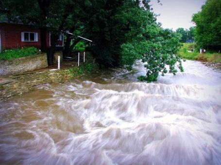
NOAA: Another Spring Of Major Flooding Likely Over North Central U.S. This latest snowstorm increased the potential for significant flooding in a little over a month. Here are some
highlights from NOAA: "
A large swath of the country is at risk of moderate to major flooding this spring, from northeastern Montana through western Wisconsin following the Mississippi River south to St. Louis, National Weather Service flood experts are forecasting. Today the agency released an initial spring flood outlook for this high risk region and will release a national spring flood outlook on March 17. For the third consecutive year, forecasters predict moderate to major flooding along the Red River of the North, which forms the state line between eastern North Dakota and northwest Minnesota and includes the Souris River Basin and the Devils Lake and Stump Lake drainages in North Dakota. If the current forecast holds, the main stem Mississippi River is at risk for moderate to major flooding from its headwaters in St. Paul, Minn., all the way to St. Louis."
Red River of the North in North Dakota and Minnesota
- Fargo, N.D., has about a 95 percent chance of exceeding major flood stage of 30 feet where portions of downtown Fargo begin flooding and temporary dike construction is necessary; and a greater than 20 percent chance of reaching or exceeding the 40.84-foot record set in 2009;
- Grand Forks, N.D., has a greater than 95 percent chance of exceeding major flood stage of 46 feet and near a 10 percent chance of exceeding the 54.35-foot record set in 1997.
Upper Mississippi River in Minnesota, Wisconsin, Iowa, Illinois and Missouri
- St. Paul, Minn., has about a 95 percent chance of exceeding major flood stage of 17 feet where secondary flood walls are deployed to protect St. Paul airport; and a 15 percent chance of exceeding the record 26.4 feet set in 1965.
"
NOAA’s flood forecasters point to several reasons for the anticipated floods. The ground in much of the north-central United States is frozen, water-saturated, and snow-covered. Forecasts for much of the region continue to call for persistent below-normal temperatures and above-normal precipitation for February, with an expectation for the snow pack to grow. In March and April, as temperatures rise and the snow melts, frozen ground and saturated soil will enhance runoff, causing streams and rivers to swell. The timing and the rate of snow melt and any rain that falls during snow melt contribute to the magnitude and extent of flooding.
“Excessive precipitation, mainly in the form of snow, coupled with continuously frigid temperatures has yielded a thick snowpack in much of the upper Midwest. We expect significant flooding when this snow begins to melt,” said Lynn Maximuk, central region director of the National Weather Service. “We urge residents in risk areas to closely monitor NOAA’s river forecasts and warnings, and prepare now for flooding.”
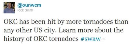
Ground Zero Of Tornado Alley. Oklahoma City has the distinction as being the most tornado-prone major metropolitan area in the USA. 126 strikes in a little over a century!
More from the Oklahoma City office of the National Weather Service: "
Oklahoma City (OKC), by virtue of its large areal extent and location near the heart of "tornado alley," has earned a reputation over the years as one of the more tornado-prone cities in the United States. In the 1960s and 1970s, news and magazine articles sometimes quoted the number of times OKC has been struck by tornadoes; that number typically was in the 30s or lower 40s, depending on the year of publication. The source of the number most likely was a local listing, kept on station at the National Weather Service Forecast Office (WSFO OKC). That list included 43 tornadoes as of 1978. Sometime later, record keeping ceased for some reason and the existing list was relegated to a binder that was lost among the growing masses of other records that accumulated at the office."
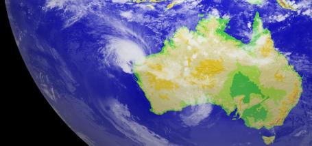
Cyclone Carlos. Australia's ABC Network has more
details on the Texas-size hurricane slamming into the west coast of Australia: "
The Bureau of Meteorology says over the next 24 hours the cyclone's centre will straddle the coast as it moves towards North-West Cape. A cyclone warning is in place for coastal areas from Whim Creek to Cape Cuvier. The bureau's Mike Bergin says coastal communities are built to withstand this type of weather. "We're not expecting to see any significant storm-surge impact and neither should we see much in the way of damage," he said."
A Busy Hurricane Season Down Under. Hurricanes are called typhoons in the western Pacific, and cyclones in the Indian Ocean and off the coast of Australia. Check out this latest
full-color image of the Pacific, which shows Cyclone Carlos.
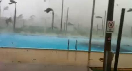
Freak Tornado Spun Up By Cyclone Carlos. It's no secret that the outer spiral bands of a hurricane can spin up tornadoes, especially when these massive storms come ashore. Check out YouTube
video of a tornado hitting the town of Karratha, Australia. The guy taking the video did the right thing and ducked indoors at the last moment, camera still rolling.
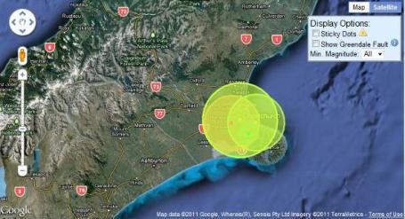
Christchurch's Seismic Fireworks, Seen On Google Maps. The Christchurch, New Zealand area has experienced a flurry of (mostly) minor tremors in the last few months, over 4,000 mini-quakes since last September, all leading up to the Big One Monday night.
More from newscientist.com: "
The people of Christchurch are reeling after a devastating earthquake struck earlier today, the second powerful temblor to hit the city in the last five months. The internet and a global, up-to-the-minute news cycle allow us to wade through death tolls, images of city blocks in ruin, even live missing persons reports. Still, for those of us who live outside of earthquakes prone areas, can we know what it's like to live in an area alive with seismic activity? Paul Nicholls of the University of Canterbury in Christchurch wants to show us. Following the magnitude 7.1 quake in September, he set up Christchurch Quake Map, a new visualisation that brings home just how seismically restless his home city is. The website combines Google Maps with data from GeoNet, New Zealand's government-backed service for monitoring earthquakes, tsunamis, volcanic eruptions and other natural hazards. The end product is something like a seismic fireworks display - a time-lapse of nearly 4900 earthquakes that have struck the region since 4 September."
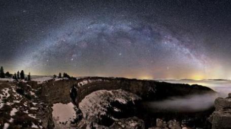
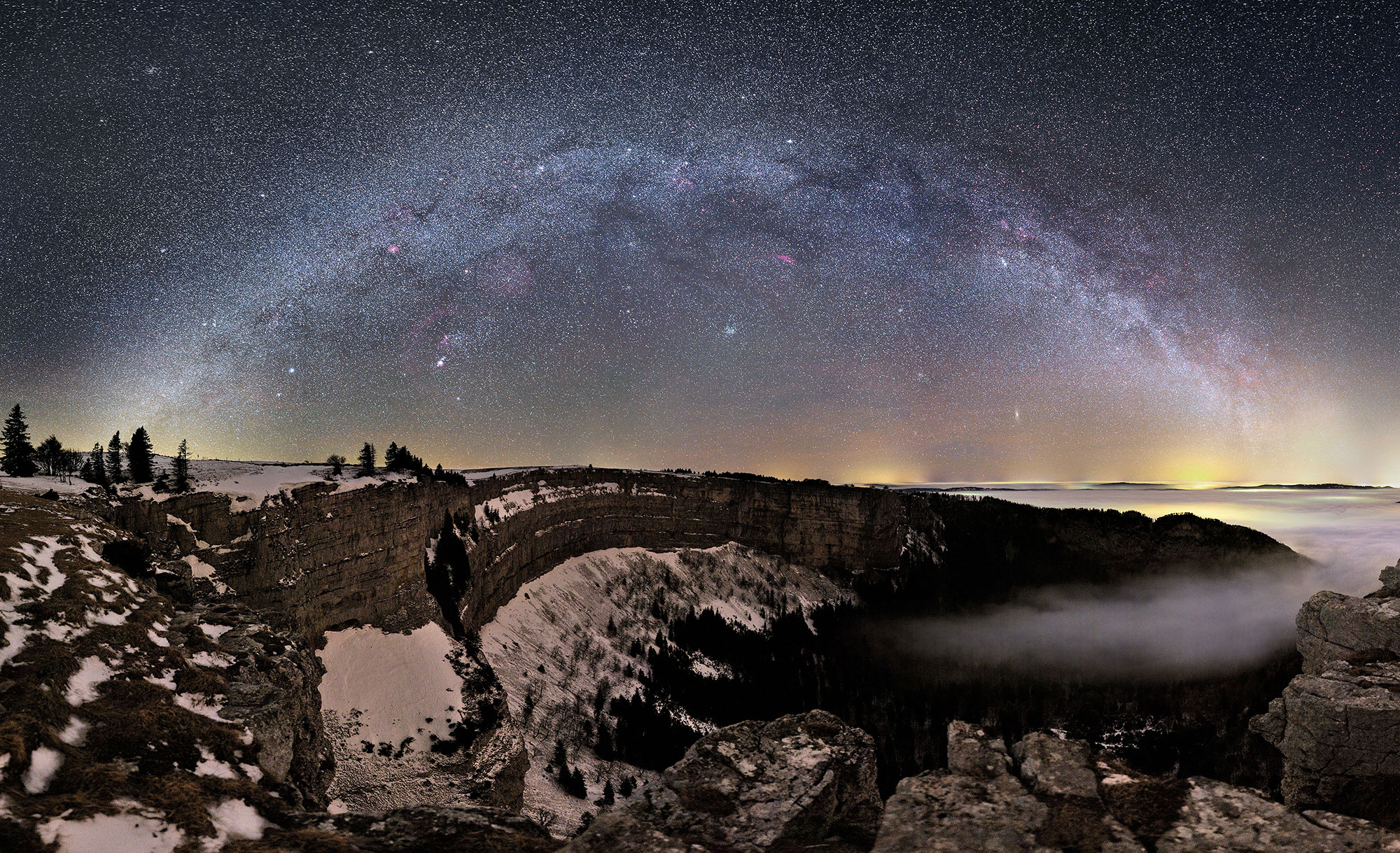
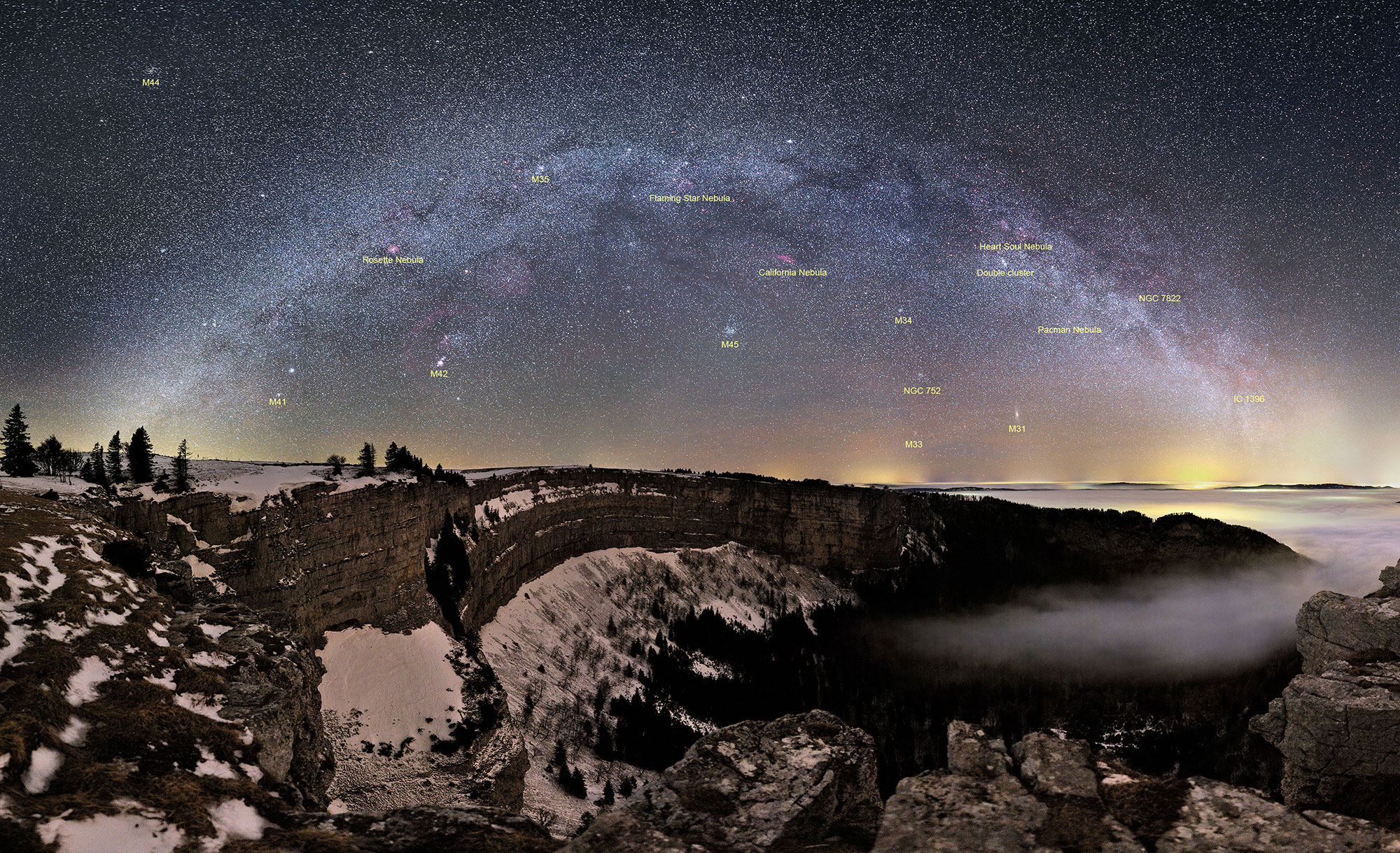
Spectacular View Of The Milky Way.
Here is a spectacular image of our Milky Way, snapped in Switzerland. From NASA: "
What's visible in the night sky during this time of year? To help illustrate the answer, a beautiful land, cloud, and skyscape was captured earlier this month over Neuchâtel, Switzerland. Visible in the foreground were the snow covered cliffs of the amphitheater shaped Creux du Van, as well as distant trees, and town-lit clouds. Visible in the night sky (at midnight) were galaxies including the long arch of the central band of our Milky Way Galaxy, the Andromeda galaxy (M31), and the Triangulum galaxy (M33). Star clusters visible included NGC 752, M34, M35, M41, the double cluster, and the Beehive (M44). Nebulas visible included the Orion Nebula (M42), NGC 7822, IC 1396, the Rosette Nebula, the Flaming Star Nebula, the California Nebula, the Heart and Soul Nebulas, and the Pacman Nebula. Rolling your cursor over the above image will bring up labels for all of these. But the above wide angle sky image captured even more sky wonders. What other nebulas can you find in the above image?"
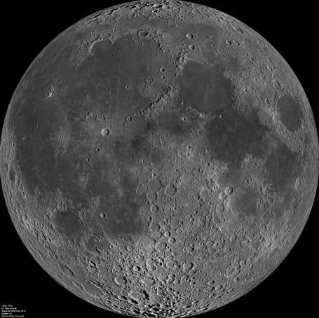 The Extraordinary Face Of The Moon
. When the moon is full, you never see the shadows, the contrasts visible in this image, which is really a compilation of 1,300 separate images. From an illuminating
article at Discover: "
This is actually a mosaic of about 1300 separate images taken by the Lunar Reconnaissance Orbiter’s Wide-Angle Camera — the total size is a whopping 24,000 x 24,000 pixels, producing a resolution of about 145 meters/pixel. The full-size version is a monster 550 Mb TIF file (seriously, don’t grab that one unless you need it!), and you can get a more palatable 1400 x 1400 pixel version with labels, too. The images were taken over the course of two weeks in December 2010. LRO is in a polar orbit around the Moon — think of it as moving in a north/south direction over the surface instead of east/west. Over time, as the Moon rotates underneath it, LRO can see the entire surface of the Moon. As it does this, the angle of sunlight changes, so care had to be taken when creating this mosaic to make it appear seamless; otherwise shadows would appear to jump suddenly from point to point. If you look carefully you’ll see where shadows point in different directions, but it still looks pretty natural."
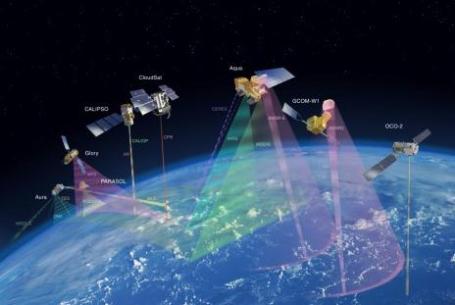
NASA Launching "Glory" Satellite Today, Part of $424 Million Mission To Measure Aerosols. An
article from treehugger.com: "
Last month, we reported on the Glory Satellite from NASA. Intended to measure airborn grit from volcanoes, forest fires, smokestacks and tailpipes, the satellite, named Glory, is part of a $424 million mission to discover more about the health of our atmosphere. NASA will launch Glory at Vandenberg Air Force Base early tomorrow morning. The scientists behind the mission state that we need to get much more familiar with these aerosols in order to know what and who they affect, and how.According to the article in Physorg, aerosols have been studied with the help of satellites for the last 50 years, but this new satellite will hopefully take the most accurate measurements thus far. As TreeHugger Mike reported last month, "After a 30-day period of tests and calibrations, it should be able to gather data for at least three years."
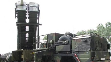
Launching Patriot Missiles? There's An App For That. Just when you thought you've seen everything, along comes an
article that would warm Steve Job's heart - from gizmag.com: "
Want to learn how to launch a Patriot missile? Turns out there's an app for that. Incorporating video of actual Patriot Missile crews in action as well as 3D animation and illustrations, C² Technologies, Inc.'s Patriot Missile mobile app trains Patriot missile crews how to position and ready the Patriot missile system to launch and fire. The app is designed to not only provide training for soldiers at any time and any place, but also to offer access to critical information in the field. In late September 2010, the U.S. Army selected C² to develop a series of apps for training Patriot missile crews. The company has just delivered the first segment in what will be a series of seven iPhone apps the company will ultimately provide to the Army. It was developed using the Unity 3D game development platform and using a "develop once, use twice" technical approach, the C² developed mobile apps can also be used on laptops and desktop computers as well as iPhones."
Paul's Conservation Minnesota Outlook for the Twin Cities and all of Minnesota:
TODAY: Milder, passing rain/snow shower? Winds: SW 15. High: near 35
WEDNESDAY NIGHT: Flurries taper - a little slush possible, turning windy and colder. Low: 18
THURSDAY: More clouds than sun, cooler. High: 26
FRIDAY: Light PM snow, couple inches possible. High: 17
SATURDAY: Light snow continues - cold, roads may be icy. Low: 4. high: 16
SUNDAY: Peeks of sun, not as cold. Low: 8. High: 24
MONDAY: Intervals of sun, storm-free. Low: 12. High: 29
TUESDAY: Sunny start, clouds increase - a bit milder. High: 31
Top 5 Winter?
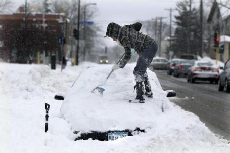
Here in the Land of 10,000 Weather Headaches even old-timers are beginning to grumble about the current (snowy) state of affairs. Monday's 13.4" set a record for the biggest February snowfall on record for the Twin Cities. At 74.9" this is already the 10th snowiest winter on record. Assuming "average" snowfall between now and April we could easily wind up with 85-90", cracking the Top 5 list. The record: 98.6" in 1983-84. Not sure we'll reach that scary number, but we may come very close.
All this snow (and no prospects for an extended, short-term thaw) increases the potential for serious flooding. According to NOAA: "St. Paul has about a 95% chance of exceeding major flood stage of 17 feet where secondary flood walls are deployed to protect St. Paul airport; and a 15% chance of exceeding the record of 26.4 feet set in 1965."
I'd like to see a few minor warm fronts, but temperatures cool into the teens by late week (a couple more inches possible Friday & Saturday); models hint at a few subzero nights late next week. In all probability spring 2011 will be delayed. When the warmth (and rain) does arrive it could be like turning on a switch. Instant meltdown. I hope I'm wrong.
Get Out The Kleenex - Climate Change Lengthens Allergy Season. Here's a recent
story at Time magazine: "For about
36 million Americans with seasonal allergies, torture time is just around the corner. As spring flowers, the pollen will flow, resulting in nasal congestion, red itchy eyes and overall awfulness. It's not just cosmetic either — for an estimated 23 million Americans
with asthma, allergies can pose a serious health threat. Nor is it cheap — allergies and allergy-driven asthma cost the U.S. an estimated
$32 billion a year. Bad news, snifflers — it's going to get worse. A
new study in the
Proceedings of the National Academy of Sciences shows a link between warming temperatures and a longer ragweed pollen season. According to researchers led by Lewis Ziska of the U.S. Department of Agriculture, the ragweed season is now 27 days longer in the northernmost areas of North America, largely because winters starts later and ends earlier, extending the time for pollen-bearing plants to thrive. It's
not the first piece of research to make the claim that global warming will worsen allergies, but it's the most detailed and it's peer-reviewed.
50 Million "Environmental Refugees" By 2020, Experts Say. Here's a
story from the Montreal Gazette: "
Fifty million "environmental refugees" will flood into the global north by 2020, fleeing food shortages sparked by climate change, experts warned at a major science conference that ended here Monday. "In 2020, the UN has projected that we will have 50 million environmental refugees," University of California, Los Angeles professor Cristina Tirado said at the annual meeting of the American Association for the Advancement of Science (AAAS). "When people are not living in sustainable conditions, they migrate," she continued, outlining with the other speakers how climate change is impacting both food security and food safety, or the amount of food available and the healthfulness of that food. Southern Europe is already seeing a sharp increase in what has long been a slow but steady flow of migrants from Africa, many of whom risk their lives to cross the Strait of Gibraltar into Spain from Morocco or sail in makeshift vessels to Italy from Libya and Tunisia."
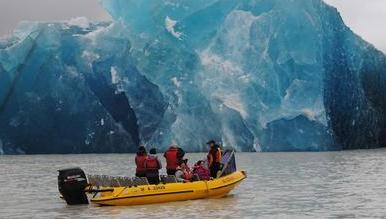
Quake Shakes 30 Million Tons Of Ice Off Glacier. The 6.3 quake that slammed Christchurch, New Zealand on Tuesday impacted nearby glaciers, as
reported by the New Zealand Herald: "
The magnitude 6.3 earthquake that devastated Christchurch was strong enough to shake 30 million tonnes of ice loose from Tasman Glacier at Aoraki Mt Cook National Park. Passengers of two explorer boats were hit with waves of up to 3.5 metres as the ice crashed into Terminal Lake under the Tasman Glacier at the mountain. Aoraki Mount Cook Alpine Village tourism manager Denis Callesen said huge icebergs formed in the lake, which were then rocked by massive waves for 30 minutes. The danger to passengers could have been worse if not for safety proceedures put in place when it was suspected the area was becoming unstable, he said."
"Climategate" Underminded Belief In Global Warming Among Many TV Meteorologists. A recent survey suggested that 1 in 3 TV meteorologists falls into the denier camp. I'm sure they would consider themselves skeptics, but in light of the depth and breadth of climate science, denier is probably the correct term to use. It's more about ideology than science, concern about "big government", a disdain for Al Gore, a belief that this is a "liberal issue", etc. An
article from NewsRoomAmerica: "
A new paper by George Mason University researchers shows that 'Climategate'—the unauthorized release in late 2009 of stolen e-mails between climate scientists in the U.S. and United Kingdom—undermined belief in global warming and possibly also trust in climate scientists among TV meteorologists in the United States, at least temporarily. In the largest and most representative survey of television weathercasters to date, George Mason University’s Center for Climate Change Communication and Center for Social Science Research asked these meteorologists early in 2010, when news stories about the climate e-mails were breaking, several questions about their awareness of the issue, attention to the story and impact of the story on their beliefs about climate change. A large majority (82 percent) of the respondents indicated they had heard of Climategate, and nearly all followed the story at least "a little." Among the respondents who indicated that they had followed the story, 42 percent indicated the story made them somewhat or much more skeptical that global warming is occurring. These results stand in stark contrast to the findings of several independent investigations of the emails, conducted later, that concluded no scientific misconduct had occurred and nothing in the emails should cause doubts about the fact which show that global warming is occurring."
* It might be helpful to read Kevin Trenberth's response to the so-called "Climategate" during a recent AMS presentation. You can find the pdf of his speech
here.


No comments:
Post a Comment