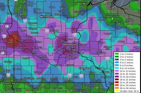
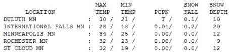
40.8" normal snowfall as of February 23.
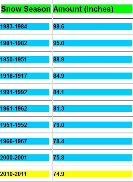
65.1" snowfall since December 1.
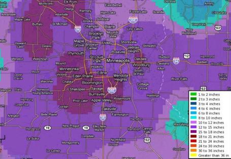
13.8" Final snowfall amount from Sunday-Monday's storm in the Twin Cities (new record for the month of February).
13" snow on the ground at KMSP as of Wednesday evening.
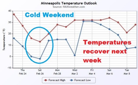
MSP Meteogram. GFS model guidance is indicating an unusually cold weekend, followed by rapid temperature recovery next week, highs consistently at, or just above 32 F, after Wednesday of next week.
ON FRIDAY INTO SATURDAY A RECORD COLD AIRMASS IS FORECAST TO DROP OVER THE REGION WITH SHOWERS AND POSSIBLE VERY LOW ELEVATION SNOW SHOWERS BETWEEN 500 FEET AND SEA LEVEL.
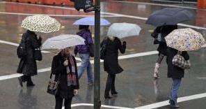
Measurable snow is very rare in San Francisco, and has only occurred in the area 11 times since 1856 according to meteorologist Jan Null of Golden Gate Weather Services, who has compiled a record. The last measurable snow to occur in San Francisco occurred in 1976 when one inch fell."
The San Francisco Examiner has more on the risk of snow in the city here.
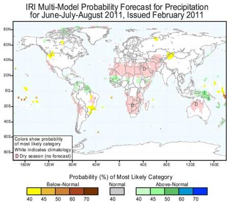
(graphic above from the International Research Institute for Climate and Society hints at drought for the central Plains this spring, gradually easing over the summer months - but lingering drought this summer possible over the Pacific Northwest, as well as parts of Brazil and China. See the latest forecasts long-range, seasonal forecasts for worldwide drought here.)
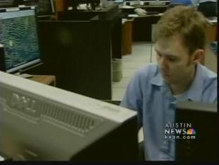
Storms May Hit National Weather Funding. At a time when severe weather is increasing, more floods, more snowstorms, more tornadoes - the last thing we can afford is a 30% cut in the National Weather Service. It would be a tragic mistake for legislators to make, and Americans will die if these cuts are enacted. Just one guy's opinion, but I feel pretty strongly that we're gambling with a lot of innocent lives. A story from KXAN-TV in Austin, Texas: "AUSTIN (KXAN) - Severe weather season is approaching. KXAN televisions viewers rely on the First Warning Forecast -- and First Warning Weather relies on the National Weather Service for some of the data it supplies. But just as tornado and hurricane seasons approach, funding for the National Hurricane Center and the NWS as a whole could be cut by 30 percent by this March should the resolution approved by the House also pass in the U.S. Senate. "This is one of my big concerns: is that if there is a decrease in the quality or quantity of the data that goes into these computer models like this on that we'll use today to help us make the forecast our forecasts are going to become less accurate," said KXAN weatherman Jim Spencer."
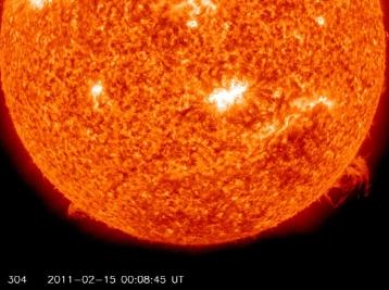
Cosmic Katrina - A Solar Superstorm Could Cost $2 Trillion. What's that George Carlin line? "Don't sweat the snow flurries?" After reading this article you may not be quite as freaked out about snow. No, now I'm a bit paranoid about our nearest life-giving star: "In the event of a major storm, researchers anticipate a widespread power outage. If such an outage lasts, they say that this could lead to “disruption of the transportation, communication, banking and finance system, and government services; the breakdown of the distribution potable water owing to pump failure; and the loss of perishable foods and medications because of lack of refrigeration,” according to the National Academy of Sciences. To determine just how significant such an event could be, scientists from the Metatech Corporation simulated the damage that the 1920 solar storm would inflict on modern infrastructure. They concluded that 130 million people could be left without power, and more than 350 electrical transformers could be permanently damaged, with the greatest U.S. vulnerability in the north west and East Coast. The price tag for such a severe solar storm of this magnitude, according to Metatech, could run from $1 trillion to $2 trillion in the first year, with a recovery time of 4 to 10 years. "


Paul's Conservation Minnesota Outlook for the Twin Cities and all of Minnesota:
TODAY: Partly sunny, cool breeze. Winds: NW 10-15. High: 24
THURSDAY NIGHT: A few clouds. Low: 9
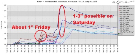
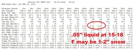
FRIDAY: Light snow and flurries. Around 1" possible. High: 16
SATURDAY: Clouds and flurries linger, still chilly. Low: 6. High: 21
SUNDAY: Milder. Light snow, coating - 1" Low: 16. High: 33
MONDAY: Windy, turning colder again. Low: 17. High: 25
TUESDAY: Clouds increase, brisk. Low: 9. High: 26
WEDNESDAY: Cloudy, flurries. Light snow north. Low: 11. High: 28
Glass Half Full?
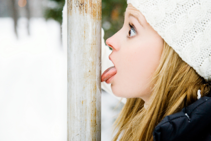
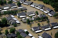
Before you let out a primal scream loud enough to wake the neighbors (the next town over) look at the bright side: The coldest subzero weather is behind us. Sure, we'll see more cold fronts, but no grinding, soul-sucking strings of negative nights. We've seen two 12"+ snowstorms (first time since the Winter of 1991-92). Pete Boulay, at the MN State Climate Office, couldn't find a winter with 3 "one-footers" going back to 1891. Aren't you feeling better already? Didn't think so. Hey, I'm trying to lift us out of our cold, glacier-infested, late-winter funk.
We're picking up over 2.5 minutes of daylight every single day; the average high reaches 50 F. by the end of March (!) Better days ahead.
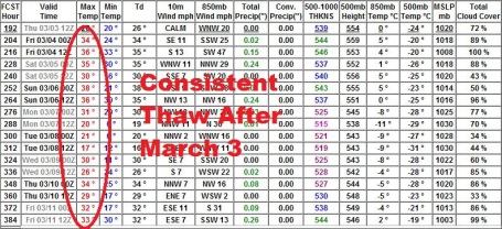
We cool off today, the next clipper-like system capable of a quick inch or so of powdery snow Friday, another inch or so Sunday. But no front-page-worthy snowstorms are lurking on the horizon. Don't pack away the coats just yet. Highs hold in the teens Friday. Next week looks chilly, maybe one night close to zero. After March 3 we should see an extended thaw, a couple weeks/row with highs above 32F. Hopefully we'll get a slow-motion meltdown, potholes and a risk of mud. In a word: progress.
Small Nuclear War Could Reverse Global Warming For Years. Now here's a smart solution for global climate change! Just press the red button, a few (modest) thermonuclear explosions should kick enough dust into the stratosphere to cool the atmosphere for years to come! From a harrowing story in National Geographic: "Even a regional nuclear war could spark "unprecedented" global cooling and reduce rainfall for years, according to U.S. government computer models. Widespread famine and disease would likely follow, experts speculate. During the Cold War a nuclear exchange between superpowers—such as the one feared for years between the United States and the former Soviet Union—was predicted to cause a "nuclear winter." In that scenario hundreds of nuclear explosions spark huge fires, whose smoke, dust, and ash blot out the sun for weeks amid a backdrop of dangerous radiation levels. Much of humanity eventually dies of starvation and disease. Today, with the United States the only standing superpower, nuclear winter is little more than a nightmare. But nuclear war remains a very real threat—for instance, between developing-world nuclear powers, such as India and Pakistan. To see what climate effects such a regional nuclear conflict might have, scientists from NASA and other institutions modeled a war involving a hundred Hiroshima-level bombs, each packing the equivalent of 15,000 tons of TNT—just 0.03 percent of the world's current nuclear arsenal. (See a National Geographic magazine feature on weapons of mass destruction.)"
Global Warming, Extreme Events and Weird Weather. Andrew Freedman from the Capital Weather Gang has a thoughtful story about linking climate change with extreme weather - that not all "extreme events" are created equal, and we have to be very careful about attribution: "One of the studies examines trends in precipitation extremes throughout much of the Northern Hemisphere, while the other investigates one particularly damaging flooding event in the U.K. in 2000. Both of the studies find that human activities have likely tipped the odds in favor of such precipitation extremes. A previous study in 2003 had found similar results with regard to the deadly European heatwave that year. As exemplified by these two studies, there is mounting evidence that the fingerprint of human-caused climate change can already be seen in the statistics of some types of extreme weather. Primarily these are precipitation extremes and warm temperature extremes, including heat waves. Other studies have also found possible manmade links to trends in hurricane intensity, and there is ongoing research examining potential changes to drought severity and frequency as well."
How Climate Change Models Could Get Better, Thanks To NASA. Why should any of us care about aerosols? An article in the Christian Science Monitor caught my eye. Here is an excerpt: "Direct and indirect effects of aerosols and black-carbon soot represent "the greatest uncertainty in our ability to predict climate," says Hal Maring, the Glory program scientist at NASA headquarters in Washington. Aerosols reflect sunlight or absorb it, cooling or heating the atmosphere depending on the particles' size and composition. Aerosols also can have indirect effects on climate by serving as tiny platforms on which atmospheric water vapor can condense to form cloud droplets. These tiny particles can vary widely in size, composition, and sources. Aerosols in the atmosphere have natural sources, such as volcanic eruptions, or can result from human activities, such as burning fossils fuels or using wood for cooking and heating. Aerosols from different sources and with different compositions can occupy the same parcel of air. Numerous field studies have monitored aerosols and black-carbon soot in individual regions. But until now, no project has provided a global view. As a result, the uncertainty in the estimates of aerosols' effects are thought to be as large as the effects being estimated."
Expert Calls For "Voices From The Political Right" To Revive Climate Change Debate. Climate change, like most everything else, has become polarized. The author argues that a common-sense middle ground needs to be found to move the debate forward. From an article at sfgate.com: "Hoffman, who is visiting at MIT Sloan from the University of Michigan, has no illusions that gaining consensus on the causes of climate change, let alone their solutions, will be easy. But with the debate currently polarized, solutions must emerge from the center. "When everything becomes so heated, it's hard for anyone to speak above the din," he said. "You need to get the extreme voices out of the space, those who present this debate in simplistic black and white, all-or-nothing terms. Instead, you have to create room for discussion with the large mass of people who are ready to debate the issue in its full complexity." This would include both those who are skeptical and those who are convinced about its causes and solutions. Hoffman distinguishes between "climate deniers," who reject both the existence and science of climate change, and "climate skeptics," who are asking serious questions and are open to discuss new information as it arises. Climate deniers "flatly reject the science and have organized with the objective of challenging any steps towards accepting its existence or mitigating its effects," he said. "They are not interested in debate and will not move from their position. But, by focusing on the truly climate skeptical we can skip the name calling by both sides and allow reasoned logic to help us move toward appropriate conclusions."
No comments:
Post a Comment