76.5" snowfall so far this winter.
9th snowiest winter on record (so far).
12" snow on the ground at KMSP.
16.1" February snowfall in the Twin Cities.
8 F. high temperature on Saturday.
32 F. normal high on February 26.
10 hours, 59 minutes, 38 seconds of daylight February 26 (2 hours, 13 minutes and 31 seconds more than on December 21, 2010, the Winter Solstice).
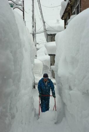
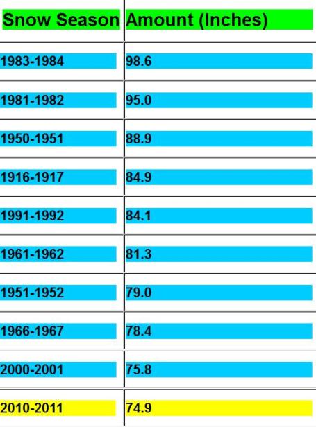
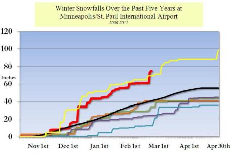
Closing In On # 9. If we pick up 84.1" of snow by the end of the snow season we'll crack the Top 5 Snowiest Winters list. Looking at the maps I don't see any way around this. We may have over 80" by the end of this week (a plowable snowfall possible on Thursday). My gut: at least a 50-50 chance of 90" of snow by late April. Average winter snowfall is 56" for the Twin Cities.
Thinking The Unthinkable. A month ago I didn't think we had a prayer of approaching the all-time snowfall record of 98.6" in 1983-83. Now I'm not so sure. We are actually trending snowier (to date) than we did during that remarkable winter. Another 20" of snow is altogether possible. At the rate we're going we will come VERY close to setting a record for the snowiest winter on record, almost certainly in the Top 3 winters. Amazing. More from the NWS
here.
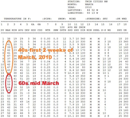 What A Difference A Year Makes
. Last March temperatures were thawing into the 40s during the first 2 weeks of the month, with readings topping 60 by mid March, 2010. We went from 12" down to a trace of snow in 11 days, from the 1st to the 11th.
 A (Very) Delayed Spring
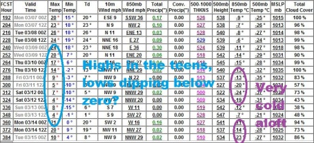
. The latest GFS
outlook keeps unusually cold (February-like) temperatures through mid March, temperatures 10-20 degrees below average with little real melting between now and March 15. The reason that's a problem? When warm fronts finally do arrive (late March?) melting may be rapid. If accompanied by rain the result may be accelerated snow-melt with a potential for severe flooding across much of the Upper Midwest. I don't want to be melodramatic here - but I have an increasingly bad feeling about the flood potential for late March and April. At the rate we're going this may be one of the worst springs for river flooding since 1997.
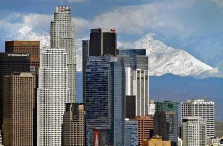 It Never Rains In Southern California - But Sometimes It Snows
. In L.A. the snow level fell to 600 feet - heavy snow showers reported in beautiful downtown Burbank!
More from the L.A. Times: "
The official snow-level may have fallen short of expectations Saturday, but that didn't prevent Los Angeles County residents from enjoying rare winter conditions this weekend. Burbank, Glendale and Studio City were some of the areas that saw flakes of soft hail or snow pellets, according to weather reports. The precipitation was part of an unusual weather system that flowed south from Canada and dropped snow and rain across much of the state. The snow level in L.A. County as of Saturday evening was about 1,700 feet, according to the National Weather Service. Earlier reports had forecast snow as low as 1,000 feet."
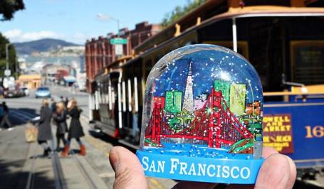
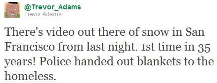
I Left My Heart (and Snow Shovel) in San Francisco. O.K. Shovels were optional - it was just flurries in downtown San Francisco - but it was the first time snow was observed downtown, at sea level, since 1976. The New York Times published an
article mocking the "no-show-snow", but it seems this was a bit premature. Early Saturday morning flurries were (in fact) spotted downtown. CBS in San Francisco
reports:
"
Snow fell on San Francisco’s Twin Peaks and Merced Heights neighborhoods early Saturday morning, according to a National Weather Service forecaster. A resident near Shields and Arch streets, located about 400 feet above sea level in the Merced Heights neighborhood, reported that snow had lightly dusted the rooftop of his home about 12:30 a.m., forecaster Rick Canepa said. “The air mass of this storm is very cold compared to other systems,” Canepa said. “I’m not surprised” about the snowfall, Canepa said. Bay Area Twitter users celebrated the icy arrival online with tweets, including “SNOWMG! It’s snowing on Twin Peaks…” and “Flurries…the ‘snow’ has arrived in SF.” Another resident near Duboce Triangle said he saw wet snowflakes in the air just before 1 a.m., though they reportedly didn’t stick to the ground, Canepa said. The snow sightings mark the first flurries spotted in the city since 1976."
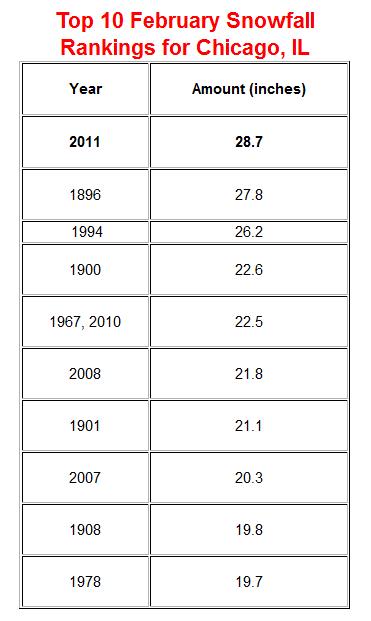
Snowiest February On Record For Chicago. From the Chicago
office of the National Weather Service: "A total of 28.7" of snowfall has been observed thus far in February 2011 at O'Hare International Airport, as of noon Saturday. This is the snowiest February on record for Chicago. Four of the top ten snowiest Februaries in Chicago have occurred since 2007. In fact, February 2011 is also currently the 9th overall for the most snow in any month in Chicago. (Not bad for having only 28 days..and having used only 26 of them so far). The snowfall total for today will be unofficial until the climate report is done at midnight. Likewise, the final total for February will of course not be known until midnight on the 28th, so this ranking may yet change.
Discovery Launch As Viewed From A Passenger Plane. Wow, talk about a front-row seat. Yes, it matters which side of the jet you sit on - that and Lady Luck. From a
story at geek.com: "
Usually when NASA launch a space shuttle we all get to see it from ground level and cameras that follow the shuttle as it disappears into the outer atmosphere. This can create some truly stunning footage, especially as the rockets fire and the initial launch happens. On Thursday Discovery got its last ascent into space, but this time instead of just seeing it from the ground, one lucky passenger flight also saw it from the air."
Use It Up, Wear It Out. According to a
story in the New York Times, consumers are holding onto their "stuff" longer. No more built-in obsolesence, replace it every 12 months. It may be more than just a backlash to the Great Recession: "
Consumer spending has picked up, but for some Americans the recession has left something behind: a greater interest in making stuff last. For a number of products — cars, phones, computers, even shampoo and toothpaste — the data shows a slowing of product life cycles and consumption. In many cases the difference is mere months, but economists and consumers say the approach just may outlast a full recovery and the return of easy credit, because of the strong impression the downturn made on consumers."
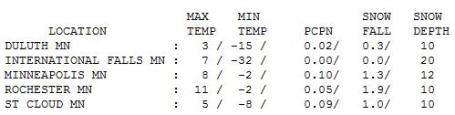
 What Month Is This Again?
 Hard to believe the sun is as high in the sky now as it was the third week of October. The high reached 8 in the Twin Cities (with 1.3" snow). St. Cloud only registered 5 degres, with an inch of snow reported. The mercury never rose above zero at Alexandria.
Paul's Conservation Minnesota Outlook for the Twin Cities and all of Minnesota:
TODAY: Peeks of sun, roads become wet. Winds: S 10. High: 29
SUNDAY NIGHT: Partly cloud. Low: 16
MONDAY: Plenty of sun, a dry sky. High: 28
TUESDAY: Mild start, PM flurries. High: 33
WEDNESDAY: Colder, blue sky returns. Low: 8. High: 17
THURSDAY: Wet snow, maybe "plowable" - few inches possible. Low: 7. High: 27
FRIDAY: Breezy and drier, few flakes. High: 24
SATURDAY: Chilled sun, where is March? Low: 3. High: 17
Playing With Fire
I'm genuinely worried about a proposed
30% cut in the National Weather Service budget for 2011. If enacted, severe cuts in manpower and data-gathering will result, impacting the Storm Prediction Center (the specialists that issue storm "watches" nationwide), the National Hurricane Center (track and warn for hurricanes), the Aviation Weather Center (forecasts of turbulence, icing, etc.), the River Forecast Center (flood warnings) & local NWS offices nationwide. Proposals on the table might launch weather balloons every other day, along with job cuts and furloughs, affecting our ability to track everything from tornadoes to floods and storms of every size. If this goes through the best weather service on Earth will suffer.
We all rely on raw data from the NWS; we're free to interpret that data and issue our own forecasts. Heaven help us if the quality of the data, storm warnings & computer models take a hit. At a time when extreme weather may be on the rise we can ill afford such draconian cuts. Yes, we have a serious deficit crisis, but is this a wise area to slash?
A few inches of slushy snow may fall on Thursday; no extended thaws in sight. Spring flooding may be extreme.
Ancient Catastrophic Drought Leads To Question: How Severe Can Climate Change Become? An
article at Science Digest caught my eye. The reality: in spite of powerful supercomputer predictions and some of the smartest minds on the planet focused on this issue, we simply don't know if we're close to a climate "tipping point". We're conducting a controlled experiment on the atmosphere, and hoping for the best. History teaches us that climate has shifted (drastically), in a relatively short period of time: "
An international team of scientists led by Curt Stager of Paul Smith's College, New York, has compiled four dozen paleoclimate records from sediment cores in Lake Tanganyika and other locations in Africa. The records show that one of the most widespread and intense droughts of the last 50,000 years or more struck Africa and Southern Asia 17,000 to 16,000 years ago. Between 18,000 and 15,000 years ago, large amounts of ice and meltwater entered the North Atlantic Ocean, causing regional cooling but also major drought in the tropics, says Paul Filmer, program director in the National Science Foundation's (NSF) Division of Earth Sciences, which funded the research along with NSF's Division of Atmospheric and Geospace Sciences and its Division of Ocean Sciences."
Ice Cores And Climate Change 101. The global temperature record goes back to the mid 1800s, but scientists rely on "proxy data", information collected from tree rings, lake bottom sediments, and the Mother Lode of frozen history: ice core samples. Here's an excerpt from a
story at treehugger.com "
Data that scientists have extracted from ice cores in places like Greenland have provided some of the most compelling evidence that the climate is rapidly warming. But it's not a widely understood concept, simple as the fundamentals of the process are. Many climate skeptics have taken advantage of this confusion to turn ice core research on its head -- and argue that it proves that humans aren't causing climate change. How could this possibly be? Watch the great video above, courtesy of the esteemed climate de-crocker Peter Sinclair, for a great introduction to ice cores, and how crafty deniers try to exploit the data they reveal.Dr. Richard Alley is one of the nation's leading climate scientists, and his pioneering work with ice cores has been invaluable to the field. He's also really fun to listen to -- his peppy presentation-style and vast store of knowledge make him one of the unofficial spokespersons for climate science. "
Climate Projectsions Show Human Health Impacts Possible Within 20 Years. A recent
story from NOAA: "
A panel of scientists speaking today at the annual meeting of the American Association for the Advancement of Science (AAAS) unveiled new research and models demonstrating how climate change could increase exposure and risk of human illness originating from ocean, coastal and Great Lakes ecosystems, with some studies projecting impacts to be felt within 30 years. “With 2010 the wettest year on record and third warmest for sea surface temperatures, NOAA and our partners are working to uncover how a changing climate can affect our health and our prosperity,” said Jane Lubchenco, Ph.D., under secretary of commerce for oceans and atmosphere and NOAA administrator. “These studies and others like it will better equip officials with the necessary information and tools they need to prepare for and prevent risks associated with changing oceans and coasts.” In several studies funded by NOAA’s Oceans and Human Health Initiative, findings shed light on how complex interactions and climate change alterations in sea, land and sky make ocean and freshwater environments more susceptible to toxic algal blooms and proliferation of harmful microbes and bacteria."


No comments:
Post a Comment