Trace: snowfall on Sunday.
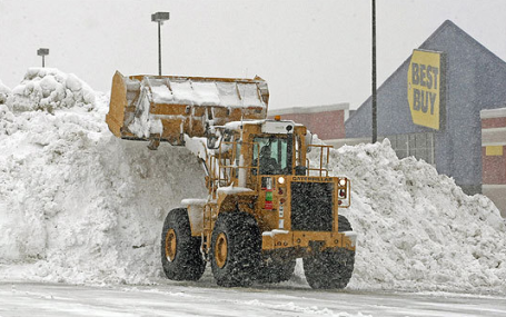
16.1" snow so far in February (nearly twice as much as we see during an average February).
12" snow on the ground in the Twin Cities.
4.91" liquid precipitation since December 1, 2010.
2.79" average liquid precipitation for MSP since December 1.

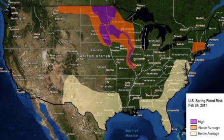
Growing Flood Risk. According to NOAA the risk of spring flooding is greatest across the Upper Midwest. Yes, we have a big bulls-eye painted right over Minnesota and the Dakotas, southward down the Mississippi to St. Louis. Here is thhe latest statement: "Information provided by NOAA on February 17, 2011 indicated Fargo, N.D. has a near 95 percent chance of exceeding major flood stage of 30 feet. At a stage of 30 feet, portions of downtown Fargo begin flooding and temporary dike construction is necessary. Approximately a 20 percent chance exists of reaching or exceeding the 40.8 foot record set in 2009. Grand Forks, N.D. has about a 95 percent chance of exceeding major flood stage of 46 feet. There is approximately a 40 percent chance of Devils Lake, ND exceeding 1,455 feet, which could partially inundate portions of the town of Minnewauken, including critical infrastructure and roads across the lake, emergency service routes and possibly a small section of the Amtrak train line. The Mississippi River is likely to see major flooding from its headwaters near St. Paul, Minnesota, downstream to St. Louis. St. Paul, MN has about a 95 percent chance of exceeding major flood stage of 17 feet, where secondary flood walls are deployed to protect the St. Paul Airport. Further downstream, the risk of major flooding on the Mississippi (Iowa, Illinois and Missouri borders) will persist into the spring. Much of that region’s snowpack typically accumulates later in the winter. The quantity of spring rains and late-season snow will determine the magnitude of flooding in the Middle Mississippi Valley."
Citizens are encouraged to remain up-to-date on flood conditions by monitoring the latest forecasts from your local National Weather Service office.
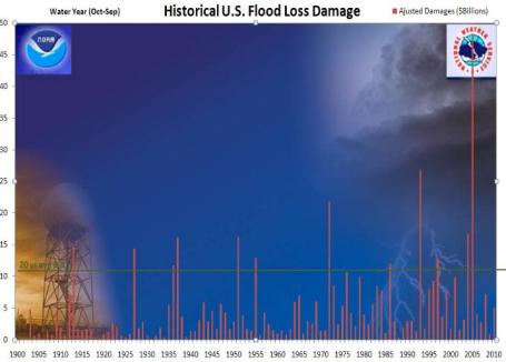
Flood Trends. There has been a notable increase in flood-related damages and costs since 1900, adjusted for inflation. The raw NOAA data is here.
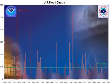
Flood Fatalities. An average of 83 Americans die every year from flooding. Most of these deaths occur at night, and are travel-related (usually people trying to cross flooded streets). What is remarkable is that, even though flood-related damage has been trending upward in recent decades, flood deaths have dropped since the 1970s. This is the result of technological advances, like Doppler radar, SKYWARN spotters and improved warning processes. Another good reason why this might not be the best time to slash budgets for the National Weather Service.
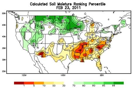
One Big Contributing Factor To A High Flood Risk. This is one of many factors, including 3-6" of liquid water locked up in the snowpack. Soil moisture is extremely high - September was the wettest on record for the Twin Cities and much of Minnesota, so the ground will be unable to soak up melting snow. Of course the ground will be frozen through the first couple weeks of April, so melting snow will almost immediately run off into streams and rivers. From NOAA: "This image, from the NWS Climate Prediction Center, shows current soil moisture values ranked by percentile. For example, areas of greatest flood risk in Montana, North Dakota and Minnesota are running values near 100%. This means those areas are seeing the highest soil moisture readings for this day, compared to a 60-year record."
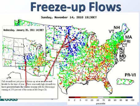
High Streamflow Levels. Another factor to consider: "Fall streamflows just priot to freeze-up at or near record levels for the time of year. These seasonally high streamflows have persisted into the winter season, with the Mississippi running at 250 percent of the mean at McGregor, Iowa."
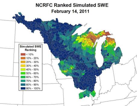
Snow Water Equivalent - SWE. The amount of water tied up in the snow on the ground is in the 90-100% range, meaning less than 10% of years since the late 1800's have had this much liquid water in the snowcover.
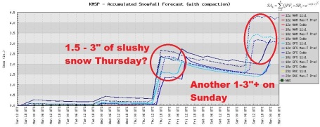
Couple of Slush-Storms. It looks quiet through Wednesday, but a wave of low pressure (aloft), coupled with a moist fetch from the Gulf of Mexico, may wring out a couple inches of sloppy, slushy snow Thursday, another couple of inches possible on Sunday. There's a good chance we'll have over 80" for the winter by the end of next weekend.
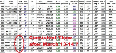
Hints Of An (Extended) Thaw. It's too early to know if this one with stick, but the GFS is suggesting a string of days above 32 F. after March 13 or 14, coming 2-3 weeks later than last year. The chance of significant snow/rain around March 14 has diminished, at least the latest model run kills off the storm. We'll see - too early to know with any certainty.

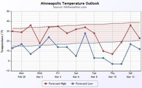
Consistently Colder Than Average. The latest "meteogram" from Ham Weather shows high temperatures close to average through March 7, followed by another burst of winter from the 8th through the 11th. A couple more subzero nights are possible around March 10 - something to look forward to.
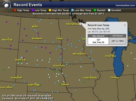
Record Lows. I counted at least 17 records for the coldest high temperature on record for February 26, and two record lows, including a face-numbing -32 F. at International Falls. Click here to see an interactive map with more information, courtesy of Ham Weather.
Plenty Of Snow Up North. There's still a cool 2 feet or more of snow across much of the Minnesota Arrowhead (reports of 3-5 foot drifts in the BWCA). Click the John Dee web site for more information on snow across the Upper Midwest (click snowcover, then click on Minnesota).
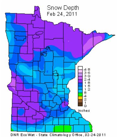
Will It Ever Turn Green Again? To me one of the greatest annual miracles is the transition from glacier-like snows to green, budding trees, in the span of a few weeks in late March and early April. According to the MN State Climate Office there is a cool 24-30" over much of southwestern and western central Minnesota, with 24-34" over the North Shore of Lake Superior.
RECORD EVENT REPORT
NATIONAL WEATHER SERVICE CORPUS CHRISTI TX
0541 PM CST SUN FEB 27 2011
...RECORD HIGH TEMPERATURE SET AT LAREDO...
A RECORD HIGH TEMPERATURE OF 103 DEGREES WAS SET AT LAREDO TODAY.
THIS BREAKS THE OLD RECORD OF 98 SET IN 1989. THIS ALSO TIES THE ALL
TIME RECORD HIGH FOR THE MONTH OF FEBRUARY SET ON FEBRUARY 20TH 1986.

Sign of Spring! Here's a sure-fire sign that spring is right around the corner (a big corner, come to think of it). The Spring Parade of Homes kicks off next weekend, runs through April 3, a great chance to check out new homes in every price range (and neighborhood in the metro area). I'm especially interested in some of the green home options. This home in Golden Valley caught my eye - geothermal power, solar panels (but very stealthy). A sign of things to come.

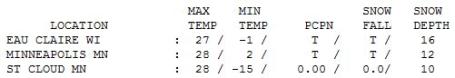
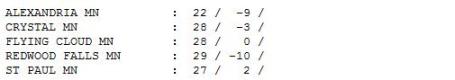
Sunday - A Big Step In The Right Direction. O.K. It felt a lot better than Saturday, when we only managed a high of 8 F. in the Twin Cities. A trace of flurries fell, a cool 12" on the ground at MSP, 10" at St. Cloud.
Paul's Conservation Minnesota Outlook for the Twin Cities and all of Minnesota:
TODAY: Partly sunny, cooler than avg. Winds: W 5-10. High: 28
MONDAY NIGHT: Clear to partly cloudy. Low: 21
TUESDAY: Increasing clouds, milder breeze. High: 35
WEDNESDAY: Intervals of sun, windy and much colder. Low: 8. High: 18
THURSDAY: Wet snow, Couple inches of slush? Low: 9. High: 29
FRIDAY: Clouds, flurries linger. High: 35
SATURDAY: Mostly cloudy and cooler, a few flakes in the air. High: 25
SUNDAY: Snow develops PM hours, slushy - potential for a couple inches. Low: 12. High: 27

In Search of Spring
Tell a friend, wake a (hibernating) neighbor: "Meteorological Winter" ends today. If you look at what is, historically, the coldest 90 days of winter (and who among us hasn't), winter really ends closer to March 1, not the 21st.
Old Man Winter stayed close to that script last year. March, 2010 brought 9 days above 40 the first 2 weeks of the month, 60s by mid March! We lost a foot of snow in the first 11 days. What a difference a year makes. A nagging La Nina is hanging on, and so will the cold. We'll top freezing Tuesday, again Friday, but no EXTENDED thaws are in sight through March 15. Who cares? The longer we delay sustained 30s and 40s, the more sudden (and severe) the Big Melt may be when it does arrive, especially if rain accompanies these warm fronts.
If you live in a flood-prone town review your flood insurance coverage; it's not too early to draft an action plan. One big wild card: how much more snow will fall, on top of our 76.5" (already the 9th snowiest on record)!?
A sloppy, slushy 2-3" may fall Thursday. No big deal. A more significant slop-storm is brewing around March 14, with over 1" of liquid, potentially heavy wet snow. No spring fever yet.


No comments:
Post a Comment