.3" fell Friday morning, shortly before breakfast.
14.8" snowfall so far in February.
11" snow on the ground at KMSP as of Friday evening.
1" predicted snow today for much of the area.
15 F. Friday's high in the Twin Cities.
32 F. Average high for February 25.

A Cold Storm. Snow at 10 F. is a lot different than snow falling at 25-30 F. When it's this cold the chemicals put down my well-intentioned MnDOT crews simply DOESN'T WORK. Traffic compacts the snow (which doesn't melt) into a thin film of glaze ice. So 1" at 8 F. can wind up being a LOT more treacherous than 6" at 30 F. I know it's counterintuitive, but trust me - it's true. Bottom line: even though we only expect a couple inches today roads will be very slick.
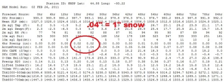
Too Cold For (Significant) Snow. The latest model run keeps the significant snow well south of MSP - we may still be brushed by about 1" of powdery snow, maybe 2" far southern suburbs - still enough to ice up some roads.
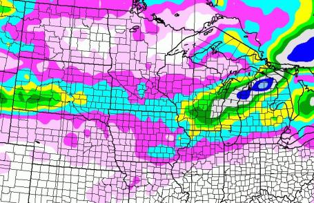
Somewhere Between Nuisance And Plowable. The best chance of 1, even 2" of snow today will come south of the Twin Cities, just (barely) enough to shovel, scrape and plow.
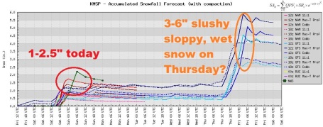
Tale of Two Snowfalls. Today's light snow will be something straight out of mid January, falling with temperatures in single digits and low teens, a light, fluffy, powdery snow (easy to get off your driveway or sidewalk), but capable of accumulating on freeways and interstates - producing an icy concoction that will slow things down. With temperatures forecast to be well above freezing by Thursday the late-week snowfall may be wet, sloppy and slushy, a classic March snowfall, possibly mixed with rain at times. Too early to get specific about next Thursday's snowfall - just a potential for now. I'm leaning more toward 1" in the immediate metro, but more south of MSP.
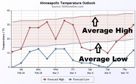
Temperature Roller Coaster. We will see a "temperature recovery" next weekend as highs approach 30, climbing into the low 30s the first few days of March. A cooling trend is likely after March 4, unusually cold weather likely from March 5-11. No prolonged spells of springlike weather - yet.
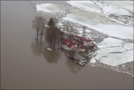
A Delayed Spring. If you look at the 90 coldest days of the winter (and who among us hasn't), winter really winds down closer to March 1, not the 21st, when spring officially begins. Meteorological Spring may kick off early next week, but there are no signs of any extended break in our cold spell. The longer we delay the (inevitable) warm fronts and rain, the worse the flooding may be. The reason? Rather than a gradual meltdown over the span of many weeks, this may be one of those springs where we go from 20s to 50s, virtually overnight. Instead of letting the air out of the balloon gradually, over time - the balloon pops. The result could be some of the worst river flooding since 1997, especially if we pick up another 10-15" of snow between now and late March, which is quite possible.
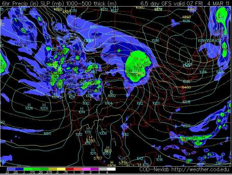
Thursday Slop-Storm? It's early, any precipitation next Thursday is still 5 days away, but models are hinting at a mix of rain and snow by then as warmth and moisture surges north from the Gulf of Mexico. There's still a potential for a few inches of heavy, wet, sloppy snow.
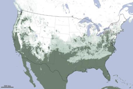
January Flashback. NASA's Earth Observatory has a story highlighting the extensive snow cover, which peaked at 71% of the lower 48 states on January 12, the 5th greatest extent of snow cover in the last 45 years: "January 2011 was marked by a series of crippling snow storms across the United States. By January 12, about 71 percent of the country had snow on the ground, the fifth-largest snow cover extent in the last 45 years. This image, made with data from the Moderate Resolution Imaging Spectroradiometer (MODIS) on NASA’s Terra satellite (from the monthly snow cover product), shows the maximum snow cover for the month. The image shows that every state in the contiguous United States, with the exception of Florida, got snow in January."
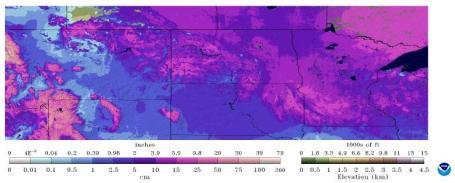
A disconcerting feature of the week's heavy snow storm is the high water content which will add to the spring flood risk on some watersheds. Some of the higher precipitation quantities reported for February 20-21 included:
1.10 inches at Hastings and Zumbrota
1.12 inches at Theilman and Winnebago
1.16 inches at Worthington
1.20 inches at Morgan and Ortonville
1.21 inches at Browns Valley
1.25 inches at Jordan
1.32 inches at Fairmont and Madison
1.37 inches at Montevideo
1.80 inches at Springfield
1.93 inches at Lake City
All of these numbers are 2-3 times the normal February total precipitation values."
Ticking Time Bomb. I don't mean to be melodramatic, but NOAA estimates suggest over 6" of liquid water locked up in the snow over parts of central and southwestern Minnesota. If we experience a sudden thaw, accompanied by significant rain, the subsequent flooding could be serious, possibly extreme. If you live in a flood-prone area you will absolutely want to stay up on the latest forecasts: the greatest potential for flooding late March into mid April.


Tombstone-Toppling Winds. One of our PhD computer developers at WeatherNation writes, "so how strong are winds associated with a tornado when tombstones are ripped out of the ground?"
"TOMBSTONES PULLED OUT OF GROUND IN CEMETARY ... 7 HOMES DAMAGED ... ONE MOBILE HOME ABOUT 75 PERCENT DESTROYED. GRAIN BINS PULLED OFF CONCRETE PADS AND NUMEROUS FARM BUILDINGS."
More information here: http://www.spc.noaa.gov/climo/reports/yesterday.html
The answer? At least 125 mph, but possibly less if the soil is saturated and mushy - easier to topple trees (and tombstones).


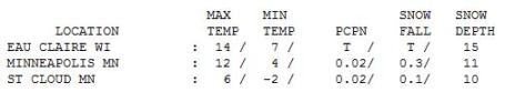
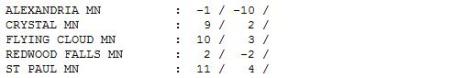
January Flashback. The high since midnight was 15 in the Twin Cities, but the afternoon high was a meager 12 F. That's 20 degrees colder than average. The high never climbed above zero in Alexandria (-1 F.). St. Cloud registered a high of only 6.

Paul's Conservation Minnesota Outlook for the Twin Cities and all of Minnesota:
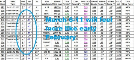
TODAY: Light snow, icy. 1-3" expected. Winds: SE 3-8. High: 13
SATURDAY NIGHT: Light snow tapers to flurries with little or no additional accumulation. Low: 7
SUNDAY: Peeks of sun, more PM flurries, possibly a period of very light snow. High: 31
MONDAY: Partly sunny, no weather headaches expected. Low: 19. High: near 30
TUESDAY: Turning cooler, few PM flakes. Low: 20. High: 30
WEDNESDAY: Intervals of sun, still quiet. Low: 14. High: 28
THURSDAY: Slushy rain-snow mix? Low: 22. High: 38
FRIDAY: Cooler, clouds and flurries linger. Low: 27. High: 33

A Cold Inch Of Snow?
I'm just the messenger! Please address all threatening letters and e-mails to "La Nina", courtesy of the Pacific Ocean. A strong cooling of equatorial Pacific Ocean water continues to linger. This cooling trend, coupled with a negative phase of the North Atlantic Oscillation (huh?), has resulted in an amazingly persistent blocking pattern, a steady stream of Canadian air plunging south of the border.
La Nina's usually weaken by April, but there's little doubt that spring will be delayed this year - I don't see any consistent thaws until the latter half of March, at the earliest. That may mean a sudden rush of warmth (and rain), with obvious implications for Minnesota's flood risk.
Hard to believe the average high is 33 F. Today will be 20 degrees colder than normal, resulting in a powdery, fluffy snow more typical of mid January. Only 1" should fall, maybe 2" far south metro, but when it's this cold roads wind up snow-covered and very icy by midday. 32 F will feel good Sunday, again late next week.
No mega-storms are brewing (yet), but we're watching a potential for a rain-snow mix the end of next week. La Nina winters are often followed by a spike in spring tornadoes. Something to look forward to.

* Another, equally troubling article about geoengineering was just published in Scientific American.

World's Coral Reefs "Will Be Wiped Out By 2050", Researchers Warn. From a story at the U.K.'s Daily Mail: "Tens of thousands of miles of stunning coral reefs could be obliterated by 2050 due to pollution, climate change and overfishing, experts have warned. Virtually all of the world's most beautiful reefs from the Indian Ocean to Australia and the Caribbean are at 'dire risk' of being wiped out, researchers said in the starkest warning yet on coral reefs. Environmentalists warned that the consequences for countries that depend on the reefs for food and income would be devastating."
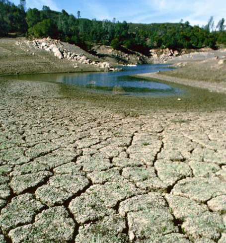
Mega-Droughts Once Reigned Supreme In The Southwest, And May Again. The first U.S. city to run out of water? Odds favor Las Vegas. But Phoenix and Los Angeles may experience serious water shortages within the next 10-20 years. USA Today has an article about perpetual drought in the southwestern USA: "Something else to worry about over the weekend: As the southern tier of the USA suffers through a drought that stretches from Arizona to Virginia – a distance of some 2,000 miles – new research this week finds that "megadroughts" used to be a common feature of the southwestern USA, and may be again, thanks to our favorite villain, climate change. These "megadroughts" lasted for, um, millennia, which I think is a long, long time. The authors, in a study published this week in the British journal Nature, say that "megadroughts" were a regular feature of Pleistocene interglacial periods in the Southwest, which were some 370,000 to 550,000 years ago. The study suggests that if it wasn't for man-made climate change, this region would probably now be entering a cooler, wetter phase."

No comments:
Post a Comment