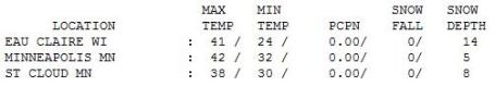
61.1" snowfall so far this winter at KMSP.
.7" February snowfall.
5" Snow on the ground as of Tuesday evening at 7 pm.
42 F. High on Tuesday in the Twin Cities
28 F. Average high for February 15.
30 F. High temperature on February 15, 2010.
63 F. Record high for February 15 (1921).
Weather Headlines: 40s linger today and Thursday, readings 15-20 degrees above average for mid February. A little drizzle is possible Thursday, giving way to flurries Friday as temperatures fall. A colder front is brewing for late week, but nothing Arctic is in sight. Saturday looks like the sunnier, drier day of the weekend, clouds increase Sunday, a period of light snow possible late Sunday into Monday morning as a sloppy, southern storm tracks south/east of Minnesota. No major storms are in sight, just a slow cooling trend through the last few days of February. Enjoy this spell of March-like weather!
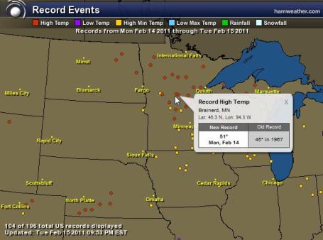
Record Warmth. Ham Weather (a division of WeatherNation) has an
interactive map that displays records, in this case Monday and Tuesday's record maximum and minimum temperatures - a couple dozen just in Minnesota. These temperatures are more typical of mid March than mid February (and no, it's not global warming - it's just "weather").
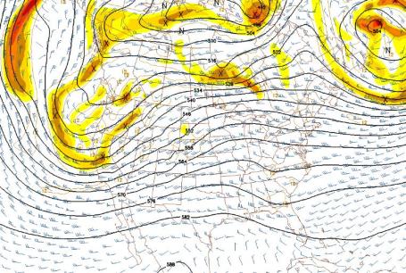 A Dramatic Shift.
 Upper level winds (500 mb, roughly 18,000 feet above the ground) are blowing from the southwest; the blocking pattern that kept feeding unusually cold air southward out of Canada has (finally) broken down - the result should be above-average temperatures through much of next week, followed by a cooling trend the last week of February.
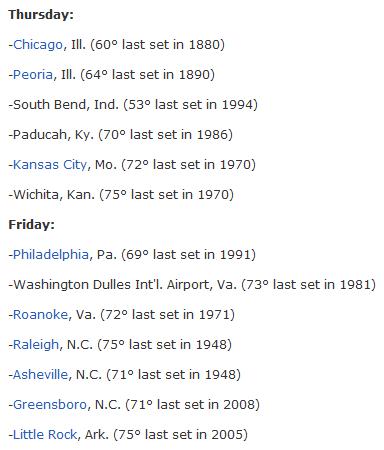
Warmth This Week To Challenge 100-Year-Old Records. Heather Buchman from Accu-Weather
lists the cities (above) that may set record highs later this week as mild, Pacific air sweeps across the nation. From subzero temperatures late last week to 60s and 70s a week later. Remarkable.
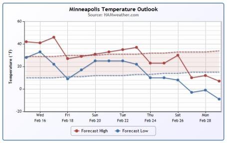
Twin Cities Meteogram. A gradual cooling trend is likely over the next 15 days - but temperatures trend well above average through February 24. The GFS model is hinting at highs in the teens by the end of the month. Click here to check out the Ham Weather interactive
meteogram generator (what a party!) I discovered that the average high temperature rises from 29 F. on the 14th to 34 F. by the 28th. No, highs won't be staying in the 40s indefinitly - at some point there will be a "correction."
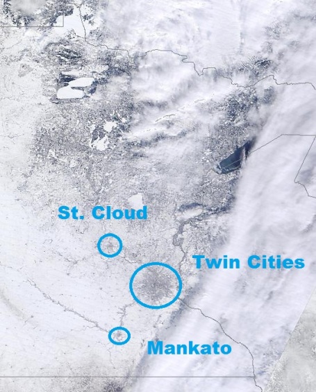
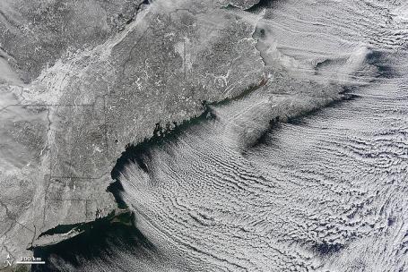
Minnesota From Space. A low-orbiting NASA (
Terra) satellite flying over Minnesota at an orbit of over 200 miles snapped this pic midday Tuesday. Metro areas appear gray (less snow, fewer fields to reflect snow back into space). That's why Twin Cities metro temperatures are often 3-8 degrees warmer than surrounding towns - the urban heat island can have a big impact, especially on clear nights with light winds.
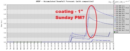
Fizzling Snow Potential For Monday. Latest models keep Sunday night and Monday's storm far enough south/east of the Twin Cities for only a minor snow event, possibly a coating to an inch of slush from Sunday evening into the morning hours Monday. We're not entirely out of the woods (yet). If the storm tracks farther north/west we could still be in the zone of heavier (wet) snow, but the trend seems to be toward shifting the significant precipitation into Iowa and southern Wisconsin.
Sunday Night Slush. The GFS model (valid 1 am Monday morning) shows the heaviest precipitation (mostly rain) setting up over southern Wisconsin. It's still a bit close for comfort - I'll keep you posted.
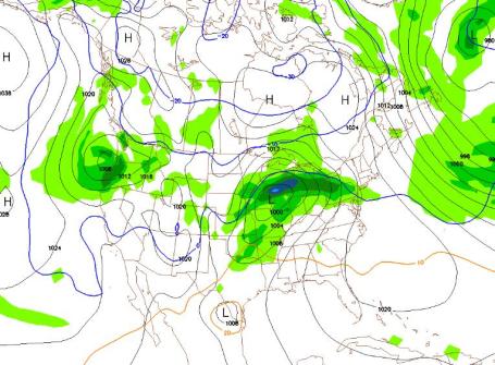
The Wild Winter of 2010-2011. Jeff Masters has an eye-opening
post summarizing just how crazy this winter has been across the USA. A few highlights (or low-lights?):
Chicago, Illinois Third greatest snowfall in history with 21.2" (O'Hare Airport) on January 31-February 2. (Single greatest storm is 23.0" on January 26-27, 1967).
Tulsa, Oklahoma: All-time 24-hour snowfall of 14.0” on January 31-February 1 leads to all-time greatest snow depth of 16.0” by February 2. Also, Tulsa has now had its snowiest single month on record with 22.5” as of February 15 (old record was 19.7” in March 1924).
Arkansas: Almost an all-time state snowfall record for 24-hour and single-greatest-storm was set at Siloam Springs in Benton County with 24.5” of snow on February 9th. One foot of this fell in just 3 hours near Jasper between 5:30-8:30 a.m. The state record still holds at 25.0” at Corning on January 22, 1918.
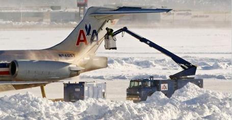
Airlines Beat Storms By Canceling Ahead. Have you noticed changes down at MSP? Flights canceled before a flake of snow falls? You're not imagining it. Here's an excerpt of a
story running in the New York Times: "
Since Christmas, four major winter storms, one after the next, shut down many of the nation’s largest airports for at least a few hours and some for a whole day. About 86,000 flights from Nov. 1 through Feb. 11 were canceled at the top 200 airports, according to Flightstats.com, putting this winter on track as one of the most difficult to navigate. Even so, the severity of the storms was only part of the story this year. The airlines, stung by highly publicized incidents in previous years of planes stuck on the ground for hours by snowstorms, have changed their policies. They have become more aggressive in canceling flights beforehand rather than trying to fight their way through the snow. At the same time, they have made it easier for passengers to cancel or rebook their travel plans, often by waiving fees."
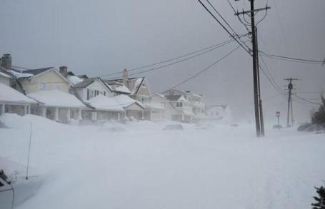
Cleanup For Huge Chicago Snowstorm Cost $8 Million. A
story from USA Today and AP on Chicago's 3rd largest snowfall on record: "
CHICAGO (AP) — Chicago's largest snowstorm in years cost the city at least $8 million. The storm dumped more than 20 inches of snow on the city, leading to a virtual shut-down for more than a day. Hundreds of motorists were stranded on Lake Shore Drive and Chicago Public Schools instituted two rare snow days."
Lessons Learned/Reinforced By Winter of 2010-11. Stu Ostro over at the Weather Channel has an insightful, detailed
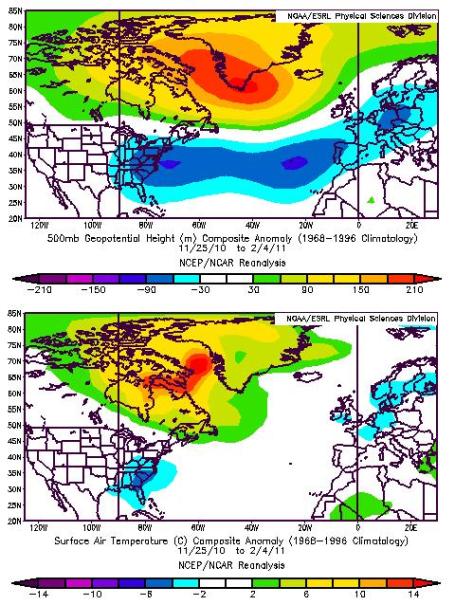
post focusing on how the combination of La Nina (cooling of Pacific ocean water) and a negatively-phased NAO (North American Oscillation) have created a "blocking pattern", one that has favored record warmth for much of the Arctic region, while pushing bitter cold (and record-breaking snowstorms) farther south, into the USA. An excerpt:
- A key area of scientific research recently has been, and ought to continue to be, connections between reduced arctic sea ice and current / potential future changes in atmospheric circulation patterns.
"Those ridges, i.e. the weather pattern at times this season, may have been influenced by the record low Arctic sea ice extent in December and January, and we need to focus on further understanding the nature of the processes involved. Prior to this winter, I was intrigued about the possibility, but a little, uh, skeptical about the degree (no pun intended) of influence that had occurred so far. Now I am convinced that the loss of sea ice is having a significant effect upon weather not only locally but also downstream."
- Global warming and extreme snowfall are not mutually exclusive.
"In fact, as I have been documenting for years, there is evidence that the former is playing a role in the latter (and in unusual cold events), by way of those ridges of high pressure. Also, the recent extraordinary extremes in precipitation are consistent with there being increased moisture in a warmer global atmosphere. Yet, more moisture alone is not enough to explain the details of what's happening in the day-to-day weather outcomes; that's where the atmospheric circulation (those ridges etc.) comes into play along with changes in stability, as processes are required to focus and lift the water vapor and turn it into historic amounts of precipitation that have been frequently occurring lately, in the form of both rainfall and snowfall, such as has happened yet again in recent days (this time snow in South Korea)."
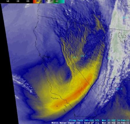
"Mountain Waves". Passengers flying to the western USA have reported moderate to severe turbulence in recent days as powerful storms have swept inland from the Pacific. The University of Wisconsin CIMSS
weather blog takes on the topic of mountain waves, the interaction of air and terrain, that can leave you juggling your orange juice at 30,000 feet. Not much fun. "
Strong southwesterly winds aloft interacting with the rugged terrain of the Sierra Nevada mountain range resulted in a number of pilot reports of mountain waves which were producing moderate turbulence over parts of the western US on 14 February 2011. AWIPS images of a composite of 8-km resolution GOES-11 (GOES-West) and 4-km resolution GOES-13 (GOES-East) water vapor imagery (above) revealed a classic mountain wave signature just downwind of the Sierra Nevada. The “seam” between GOES-11 and GOES-13 is fairly evident on the AWIPS water vapor image composite, mainly due to the difference in spatial resolution."
"Cloud Streets". Whether it's a memorable sunset, an amazing cloud formation, or the view from space, I'm continually amazed (and humbled) by the artistry of nature. NASA's Earth Observatory has a good
post focused on the phenomenon of cloud streets, how they form, the dynamics necessary to create these amazing, parallel lines of cloud cover: "
Cloud streets form when cold air blows over warmer waters, while a warmer air layer—or temperature inversion—rests over top of both. The comparatively warm water of the ocean gives up heat and moisture to the cold air mass above, and columns of heated air—thermals—naturally rise through the atmosphere. As they hit the temperature inversion like a lid, the air rolls over like the circulation in a pot of boiling water. The water in the warm air cools and condenses into flat-bottomed, fluffy-topped cumulus clouds that line up parallel to the wind."
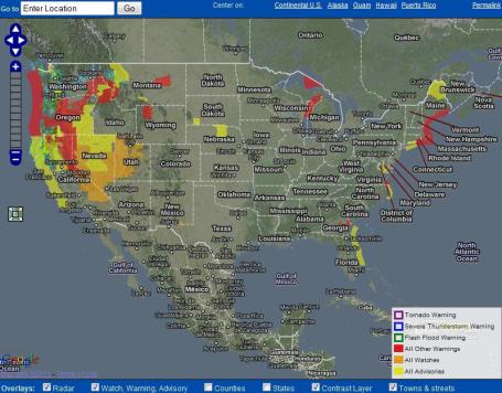
New Experimental NOAA Warning Tool. Click
here to learn more about a new, interactive tool for displaying watches, warnings and advisories: "
This is a experimental non-operational test of proposed watch, warning and advisory displays from the National Weather Service. Please read the official Product Description Document (PDD) for information regarding this experimental product. Public comments and suggestions about this page are encouraged."
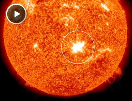
First "X-Flare" Of The New Solar Cycle. Things are heating up on the sun (sorry). After a notable, lengthy absence of sunspots and solar flares, the sun is seeing a sudden spike in activity, as described at
spaceweather.com: "
Sunspot 1158 has unleashed the strongest solar flare in more than four years. The eruption, which peaked at 0156 UT on Feb. 15th, registered X2 on the Richter scale of solar flares. NASA's Solar Dynamics Observatory recorded an intense flash of extreme ultraviolet radiation."
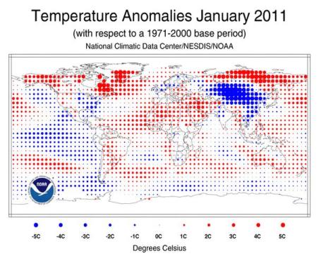
NOAA: January 2011 Was 17th Warmest On Record. The latest from NOAA: "Last month was the 17th warmest January for combined global land and ocean surface temperature since records began in 1880. La Niña, with its cooling effect on the central and eastern tropical Pacific, continues to be a factor in global ocean temperatures. The monthly analysis from
NOAA’s National Climatic Data Center is part of the suite of climate services NOAA provides government, business and community leaders so they can make informed decisions."
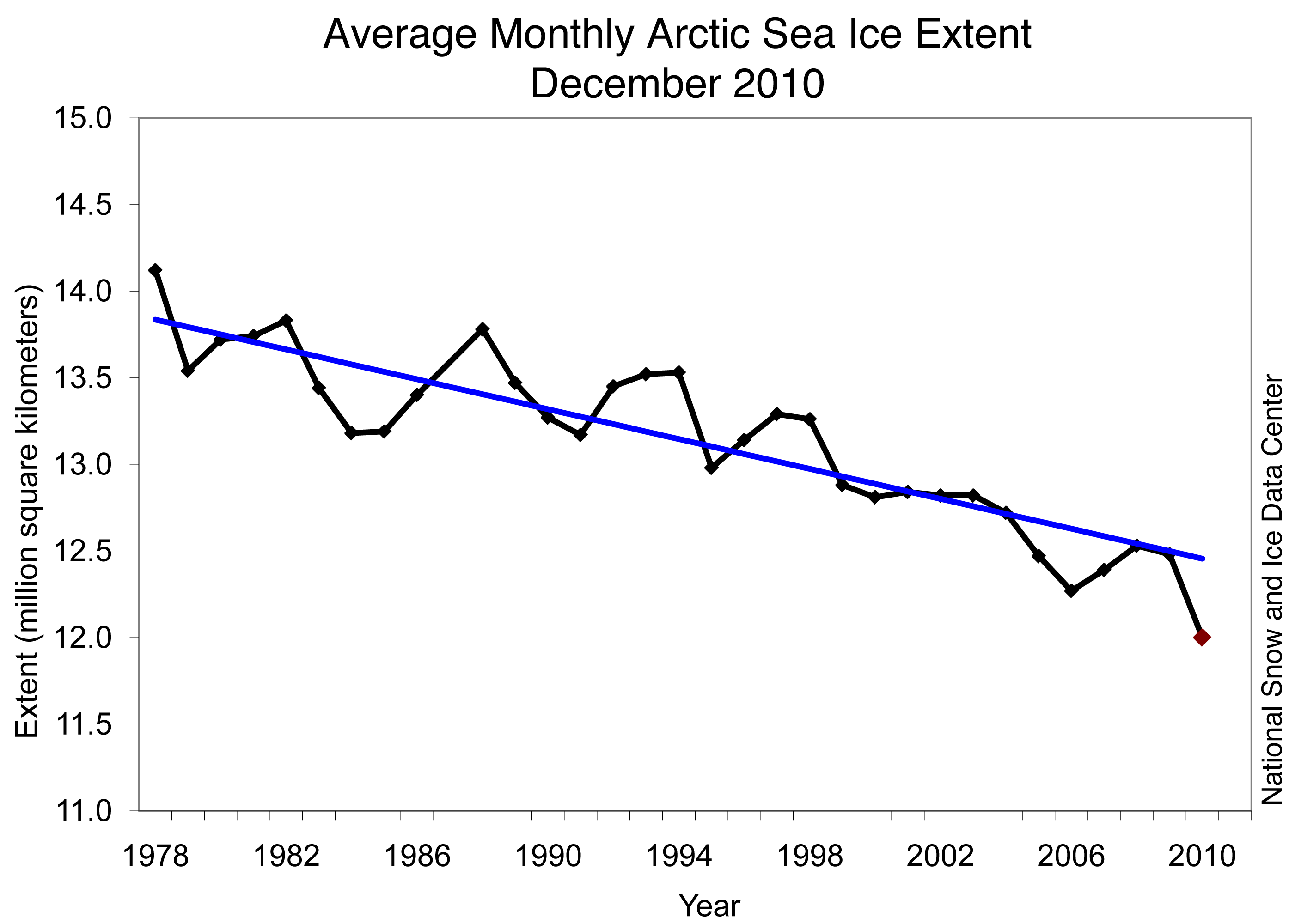
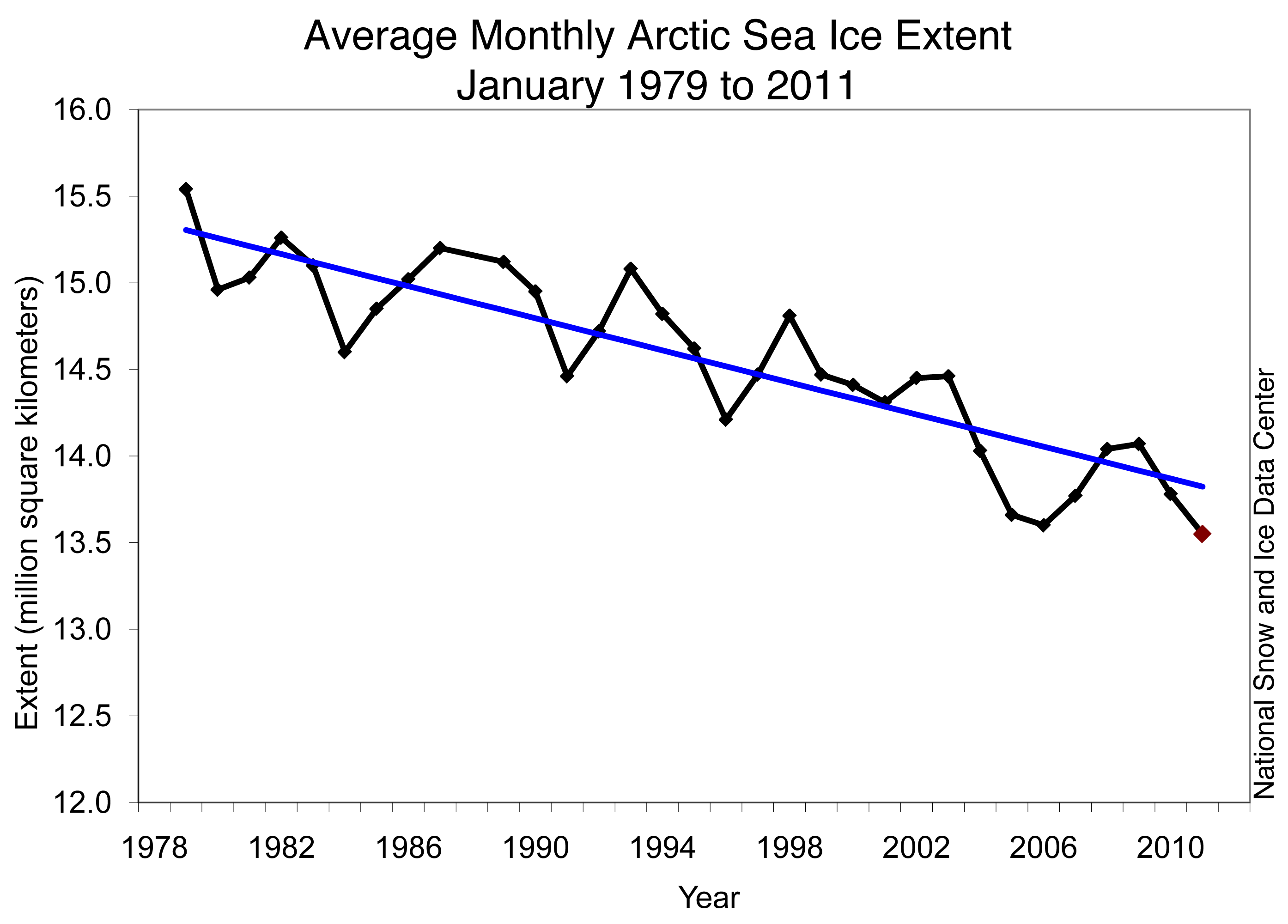
Polar Sea Ice and Precipitation Highlights:
- The average Arctic sea ice extent for January was 5.23 million square miles (13.55 million square km), which was 8.7 percent below average. This ranks as the smallest January Arctic sea ice extent since records began in 1979 and the second consecutive month with record low Arctic ice extent.
- The January 2011 Antarctic sea ice extent was 7.5 percent below normal, and was the eighth smallest January ice extent since records began in 1979.
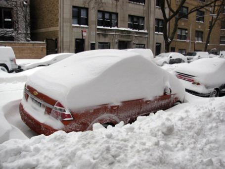
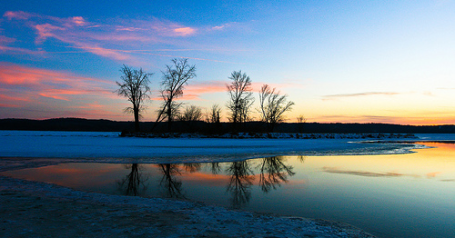
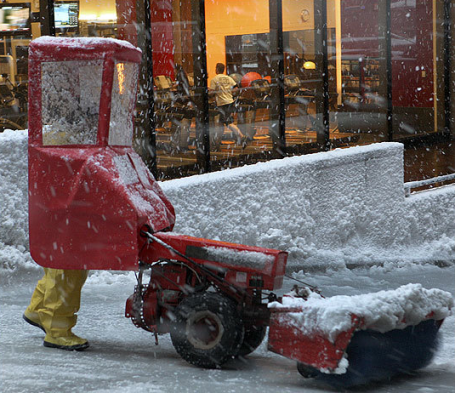
Way Too Early For Spring Fever. Talk about an atmospheric sucker-punch. There is something miraculous, and a bit unsettling, about low 40s in mid February. The Twin Cities lost another inch of snow (down to 5" from 11" Sunday evening). St. Cloud snowfall has dropped from 16" last week to 8" as of Tuesday evening.
Paul's Conservation Minnesota Outlook for the Twin Cities and all of Minnesota:
TODAY: Some sun, hints of spring. Winds: S 10-15. High: 42
WEDNESDAY NIGHT: Clouds increase, unusually mild for mid February. Low: 32
THURSDAY: Gray, drizzle likely, but mild. High: 48
FRIDAY: Gusty & colder, flurries north. High: 32
SATURDAY: Plenty of sun, feels like February again. Low: 16. High: 33
SUNDAY: Clouds increase, light snow late. Low: 21. High: 36
MONDAY: Light snow tapers, a little slush? Low: 26. High: 34
TUESDAY: Sunny start, clouds increase - slushy mix late? High: 32
The Big Drip
In addition to lowering blood pressure and pulling all of us out of a cold, dark funk, this week's thaw may take some of the edge off spring flooding in 25-45 days. I say that with all humility and respect, because flood forecasting is a science within a science. I defer to National Weather Service hydrologists, flood forecasters, who take into account thousands of variables before issuing their warnings. Last September was the wettest ever observed, in fact 2010 was Minnesota's soggiest year on record, an average of 34" statewide. We went into winter with wet soil. Add 50-70" snow, about 3-6 inches of water equivalent, and you have a recipe for serious flooding come March and April. We'll see.
Welcome to pothole season! Water has the unpleasant characteristic of expanding as it freezes. During the day water seeps into cracks in the roads, which freeze, expand, and slowly pulverize the highway surface, resulting in a moonscape of crater-size ruts.
Mild weather lingers into Thursday, mid to upper 40s likely (with drizzle), followed by a weekend cooling trend. A southern storm may brush Minnesota with a little light snow late Sunday into early Monday; doesn't look like the Big One.
International Arctic Climate Study To Begin. Canada's CPC has a
story about a sudden scramble among nations to cope with melting ice (and permafrost) - happening considerably faster than the models were predicting even 5-10 years ago. Here's an excerpt: "
Canada and its Arctic allies will launch a major study this spring to help northern nations cope with the irreversible effects of climate change. The speedy melting of polar ice is the driving force behind the Arctic Council's decision to announce the wide-ranging study. The project, called the Arctic Change Assessment, will be disclosed when Foreign Affairs Minister Lawrence Cannon and his seven counterparts meet this May in Greenland."
Survey: Scientists Agree Human-Induced Climate Change Is Real. This article is from 2009, but it's as relevant as ever. Don't be fooled by recent cold and snow ("weather"). No climate scientist ever claimed that winter would be put on indefinite hold in Minnesota. I encourage people with an open mind (and there are still some of those folks out there) to try and keep the big - global - long term - pattern in mind. Don't fixate on any one day, month or season, but follow trends over many decades, on a planetary scale, which is a lot more challenging than just looking out the window at your thermometer and shrugging all this climate-talk off as utter nonsense. From the
article: "
Two questions were key: have mean global temperatures risen compared to pre-1800s levels, and has human activity been a significant factor in changing mean global temperatures. About 90 percent of the scientists agreed with the first question and 82 percent the second. In analyzing responses by sub-groups, Doran found that climatologists who are active in research showed the strongest consensus on the causes of global warming, with 97 percent agreeing humans play a role. Petroleum geologists and meteorologists were among the biggest doubters, with only 47 and 64 percent respectively believing in human involvement. Doran compared their responses to a recent poll showing only 58 percent of the public thinks human activity contributes to global warming. "The petroleum geologist response is not too surprising, but the meteorologists' is very interesting," he said. "Most members of the public think meteorologists know climate, but most of them actually study very short-term phenomenon." He was not surprised, however, by the near-unanimous agreement by climatologists. "They're the ones who study and publish on climate science. So I guess the take-home message is, the more you know about the field of climate science, the more you're likely to believe in global warming and humankind's contribution to it."
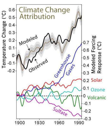
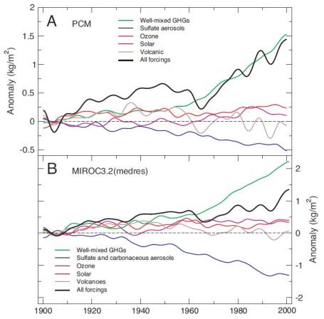 Update
. 5 different "forcings" were considered in a more recent paper examining the impact of GHGs (greenhouse gases), sulfates, ozone, solar fluctuations and volcanoes. GHGs were found to the predominant forcing mechanism on climate change - little or no influence on global temperatures from the other factors considered.
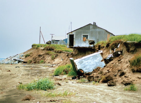 Climate Change Keenly Felt In Alaska's National Parks
. Scientific America has an
article about the transformations taking place across Alaska. Far northern latitudes are warming much faster than mid latitudes, and no state is feeling the impact more than Alaska. "
Since the mid-1970s, Alaska has warmed at three times the rate of the Lower 48 states, according to the U.S. Environmental Protection Agency. And with nearly two-thirds of U.S. national parkland located in Alaska, the issue of climate change is especially pressing there, officials say. In some far northern parks such as Gates of the Arctic, average temperatures are expected to shift in coming years from below freezing to above freezing, crossing a crucial threshold, said Bob Winfree, Alaska science adviser for the Park Service. "The effects of melting ice and thawing permafrost, I think, will be major," Winfree said."


No comments:
Post a Comment