41.1" average snow as of February 24.
14.5" snow so far in February.
7" average snow as of February 24 in the metro area.
11" snow depth at MSP International Airport at 7 pm Thursday evening.
4198 degree days since December 1, 2010.
4153 average number of degree days since December 1.
1% Since December 1 consumption of electricity to warm homes, schools and businesses has run about 1% more than average. In terms of temperature it's actually been a very "normal" winter in the Twin Cities. Snow? That's a different story.

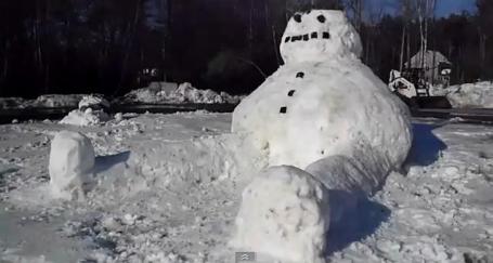
Only in Minnesota.There have to be easier ways to stay in shape during the doldrums of winter...
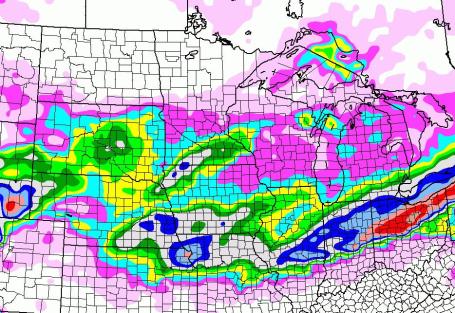
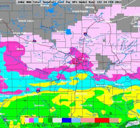
South Side Cleans Up Again. What is it about the south metro this winter? Closer to the storm track, closer to the moisture source (Gulf of Mexico)? Both pretty valid reasons. Models are hinting at 3-5" over far southern Minnesota, with the best chance of 1-3" over the southern suburbs by Sunday morning.
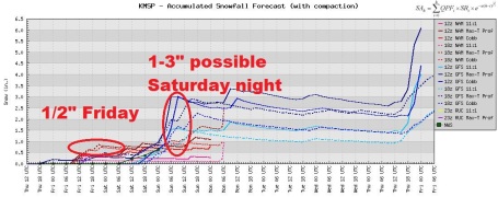
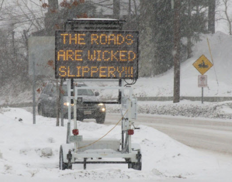
Brushed By Snow. Even though the main event will pass a few hundred miles south of Minnesota, a stormy swirl (aloft) may drop a coating to 1/2" on Friday. Another wave of low pressure may squeeze out a quick 1-3" Saturday night. Confidence is increasing - with temperatures near 10F. it won't take much moisture (or upward motion) to get a quick couple of inches of fluff late Saturday into early Sunday.
Thursday Snowfall:
2" downtown Seattle
13" Spokane
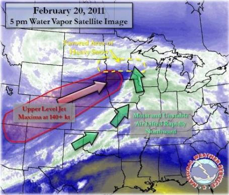
Stormy Post Mortem. The local Chanhassen office of the National Weather Service has a terrific overview of the storm that dumped 13.8" on the Twin Cities Sunday and Monday, with as much as 20" in a few southwestern metro suburbs. "After a respite of a few weeks in what is becoming one of the most active winters on record, a large and intense winter storm blanketed the region with heavy snowfall, including blizzard conditions in western Minnesota. This system developed quickly late Saturday night (19th) and into the early hours of Sunday (20th), as a strong jet stream moved across the western United States. Well above normal, deep moisture for late February, expanded north across the entire Mississippi River Valley and into the Upper Midwest. Mixed precipitation of snow, sleet, and freezing rain across southwest and south central Minnesota gradually spread northeast Sunday morning. In most areas north of the Interstate 90 corridor, the precipitation either began or quickly turned to heavy snow. Thunderstorms across eastern Nebraska and Iowa on Sunday morning pushed northward into the snowfall region of the system, leading to thundersnow and very heavy snowfall rates at times. The Twin Cities experienced the heaviest snow from late Sunday morning, through the afternoon, and into the middle of the evening. "
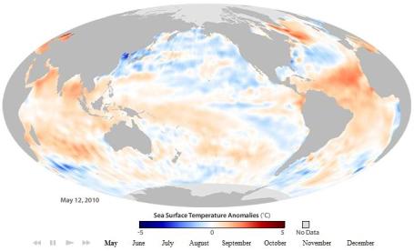
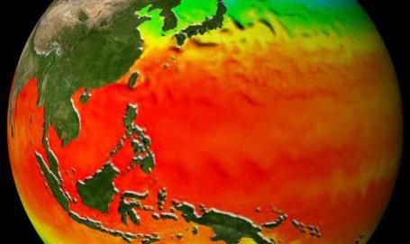
La Nina Continuing. The moderate to strong La Nina that contributed to a colder, snowier winter for much of America is hanging on - although showing some signs of weakening slightly. Why should you care? La Nina winter are often followed by unusually active tornado springs. It's hard to imagine we'll see more than 2010 (104 touched down, most in the USA), but I suspect it's going to be a very busy April, May and June for severe weather, hail and tornadoes. From NOAA: "El Niño and La Niña (collectively called the El Niño–Southern Oscillation, or “ENSO” for short), are the end points of a seesawing pattern of changes in ocean temperatures, rainfall, and wind patterns across the tropical Pacific Ocean that occurs every 3-7 years. This naturally occurring climate pattern influences weather around the globe. At one end of the seesaw is El Niño, during which ocean surface temperatures in the central and eastern tropical Pacific Ocean get unusually warm. At the other end is La Niña, in which the same part of the ocean grows unusually cool."
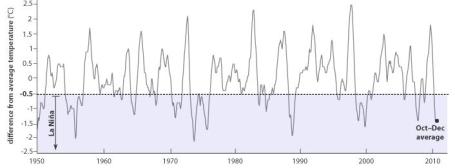
La Nina. 1950 - Present. La Niña exists when the three-month-average sea surface temperature in the central tropical Pacific Ocean (graphed line) drops to at least 0.5° C below average (shaded box). The October–December 2010 anomaly was -1.4° C. Graph by Rebecca Lindsey based on NOAA Climate Prediction Center Oceanic Niño Index data.


A True Competitor To The iPad? The New York Time's David Pogue has a good overview of Motorola's latest creation, the "XOOM", which has a lot of promise. Too bad the Android marketplace is still a mess, but the XOOM may have enough other features and functionality to make up for that drawback: "The Xoom also has a dual-core processor, which, according to Motorola, means smoother game animation. And it has cameras. On the back, there’s a 5-megapixel still camera that can also record high-definition video. On the front, there’s a low-resolution video camera for video chatting. The new Android software includes a beefed-up Camera module, which gives weird prominence to gimmicky effects you’ll never use, like Solarize, Sepia and Polarize. Clearly, a camera is useful on a tablet, and will remain a gigantic competitive advantage for the Xoom — at least until the iPad 2 comes out next month (if Apple sticks to its usual annual update pattern, that is). If the new iPad doesn’t have a camera or two, I’ll eat a tablet. The Xoom’s screen has slightly higher resolution than the iPad’s, and it gives the tablet a slightly different shape — more like a business envelope than a greeting-card envelope. The screen shape is a better match for hi-definition videos, but worse for photos and maps."
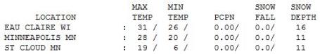
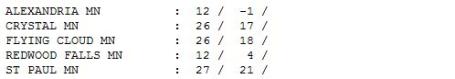
Below Average. In case anyone asks (doubtful) the average high now is 32 F. At least the sun was out, 11" on the ground in St. Cloud and the Twin Cities. By the way, last year the high on Feb. 24 was 20 F. in the Twin Cities.

Paul's Conservation Minnesota Outlook for the Twin Cities and all of Minnesota:
TODAY: Unusually cold. Coating of light snow? Winds: NW. High: 14
FRIDAY NIGHT: More flurries, a few icy roads. Low: -3
SATURDAY: Still numb. Light snow and flurries - slick spots. High: 13
SATURDAY NIGHT: Light snow, 1-3" possible with slick roads. Low: 4
SUNDAY: Fading sun, snow develops south/east of MSP. High: 28
MONDAY: Flurries give way to bright sun. High: 27
TUESDAY: Clouds increase, PM flurries. High: 26
WEDNESDAY: Intervals of sun, still chilly. High: 24
THURSDAY: Snow develops, some accumulation? High: 31
Interesting Times
Looking at the weather maps that old proverb, "may you live in interesting times" comes to mind. 2010: wettest year on record for Minnesota. Most tornadoes (104) on record. Tied for 2005 for the warmest year (globally) on record. Every time we turn around we're setting a RECORD. Earlier this week, for the first time since 1985, the Twin Cities had seen more snow (75") than International Falls and Duluth! Strange but true.
Now the concern is shifting from snow to flooding. Will this be the worst spring on the Red River since '97? If we pick up another 1-2 feet of snow could we have a year to rival the Mother Of All Floods, 1965? Too early to tell, but the rate of snow melt (and whether it rains hard and often) will seal our fate. Time to check your flood insurance policy.
A weak area of low pressure aloft may squeeze out a quick coating to 1" of (powdery) snow today; with "highs" in the teens some roads will be icy. A couple inches of snow may fall from a second disturbance Saturday night. Confidence levels are low - we need to see a few more computer runs, but there's at least a chance of some very icy roads over the weekend, especially Saturday night.
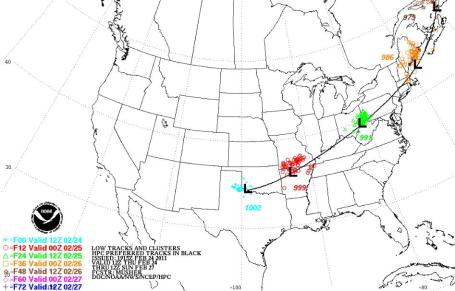
Models print out a more significant storm over the Quad Cities by Sunday night; the heaviest snow should pass south and east of town but it's a little close for comfort. March starts on a chilly note next week, but 30s arrive the second week of March. Signs of hope.


Inspector General's Review Of Stolen E-Mails Confirms No Evidence Of Wrong-Doing By NOAA Scientists. The latest from NOAA regarding the hacked "climate-gate" e-mails: "At the request of U.S. Sen. Inhofe, the Department of Commerce Inspector General conducted an independent review of the emails stolen in November 2009 from the Climatic Research Unit (CRU) at the University of East Anglia in Norwich, England, and found no evidence of impropriety or reason to doubt NOAA’s handling of its climate data. The Inspector General was asked to look into how NOAA reacted to the leak and to determine if there was evidence of improper manipulation of data, failure to adhere to appropriate peer review procedures, or failure to comply with Information Quality Act and Freedom of Information Act guidelines. “We welcome the Inspector General’s report, which is the latest independent analysis to clear climate scientists of allegations of mishandling of climate information,” said Mary Glackin, NOAA’s deputy under secretary for operations. “None of the investigations have found any evidence to question the ethics of our scientists or raise doubts about NOAA’s understanding of climate change science.”
The Inspector General’s report states specifically:
- “We found no evidence in the CRU emails that NOAA inappropriately manipulated data comprising the [Global Historical Climatology Network – monthly] GHCN-M dataset.” (Page 11)
- “We found no evidence in the CRU emails to suggest that NOAA failed to adhere to its peer review procedures prior to its dissemination of information.” (Page 11)
- “We found no evidence in the CRU emails to suggest that NOAA violated its obligations under the IQA.” (Page 12)
- “We found no evidence in the CRU emails to suggest that NOAA violated its obligations under the Shelby Amendment.” (Page 16)
Slim Pickings For Climate Science Critics In Inspector General Report. The latest from Andrew Revkin at the New York Time's Dot Earth blog: "Senator James M. Inhofe, the Oklahoma Republican and the dean of congressional naysayers on the need for action on climate and energy, appeared to come up empty-handed today. Inhofe had requested that the Commerce Department Inspector General investigate whether e-mails and other information revealed in the hacking of climate files at the University of East Anglia in December 2009 revealed any wrongdoing by scientists at the National Oceanic and Atmospheric Administration. His news release today held slim pickings if the hope was to uncover a scandal:
- A mention of a possible irregularity in some contracts with no discernible bearing on the quality of climate science.
- The phrase “warrants further action” was used in the release to describe eight e-mail messages that the inspectors found might potentially point to integrity issues. The problem is that the agency conducted interviews and document reviews and provided explanations in the report — none of which raised red flags. (Inhofe plans to pursue more investigations of these e-mails nonetheless, his release said."
No comments:
Post a Comment