76.5" snowfall so far this winter in the Twin Cities.
16.1" February snowfall at MSP.
10.5" average snowfall for March.
0" amount of snow that fell in March, 2010.
11" snow on the ground at MSP.
Weather Synopsis for people in a hurry:
we warm up into the mid 30s today; tomorrow will feel like mid January (but the sun will be out). The next chance of accumulating snow comes Thursday, when a "few inches" may fall, possibly enough to shovel and plow. Quiet weather returns for Friday and Saturday, a light coating of snow Sunday, and a potential for a significant snowfall next Monday and Tuesday as a storm tracks from Oklahoma to Chicago. Another cold slap returns the end of next week - an extended thaw may kick in after March 13 or 14. But as you'll see below, this March will IN
NO
WAY resemble March of 2010.
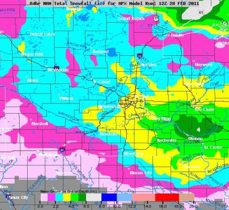
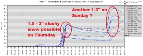
Outlook: March Slush. Models are still pretty much on-track predicting a couple inches of sloppy snow on Thursday, something in the 1-3" range for most suburbs. Models are hinting at 3-6" from Rochester and Winona to Menomonie, Wisconsin.
Barely "Shovelable". Two modest snowfalls are brewing, one on Thursday (with highs near 32 many freeways should just be wet/slushy). Sunday will be a few degrees cooler, highs in the upper 20s - so there may be a bit more slush on area highways. The good news: no Snowmageddon Outbreaks anytime soon.
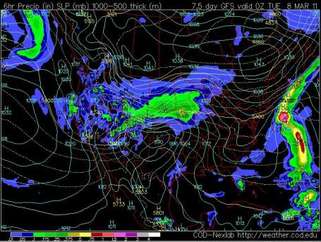
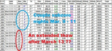
On Our Way To A 90" Winter? The weather map, valid 7 pm Monday evening, shows an intensifying storm over Oklahoma, with a huge shield of rain, ice and snow spreading across the Plains into southern and central Minnesota.
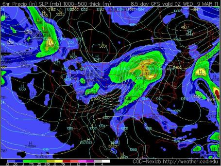
Another Big Pile? It's too early to panic (or celebrate), but the same GFS model, valid 7 pm Tuesday evening, shows a storm pushing into the Great Lakes, enough cold air in place for potentially wet, heavy snnow across much of the Upper Midwest. It's too early to venture a (guess) about amounts, but IF this forecast verifies, we could be looking at significant snow amounts Monday/Tuesday of next week. The way this winter is going, why should we count on a break?
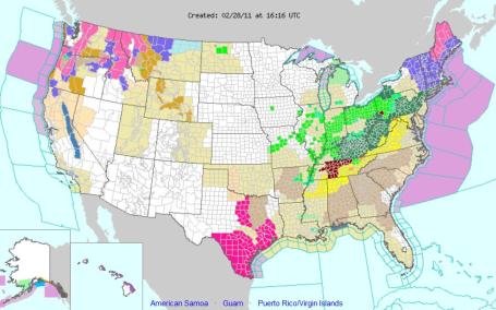
All Lit Up. All these colors on NOAA's watch/warning map can't be good news. On Monday tornado watches were posted from Huntsville to Washington D.C. Flood watches, and a slew of flood warnings from Iowa and Missouri eastward to Ohio and Pennsylvania as the Big Thaw gets going. Click
here to see the latest watches/warnings, courtesy of NOAA.
Temperature Relief? As the sun climbs higher into the southern sky the frequency and intensity of bitter cold should dial down in the weeks ahead. The GFS model is hinting at a couple of unusually cold days between March 9-11, maybe one or two nights at, or just below, the zero mark. But what may wind up being an extended thaw should set in after March 13 - that's when significant snow melt may (finally) kick in statewide.
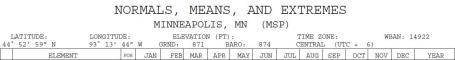
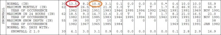
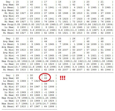
March: Second Snowiest Of Winter. The new (rolling) data set from 1971-2000 shows that January is now the snowiest month of the year in the Twin Cities, with an average of 13.5". March (which was, until recently, the snowiest month of the year) now sees an average of 10.4". The big difference? January snows tend to stick around - the snow simply DOES NOT MELT! With a sun angle by the end of March as high in the sky as it was in late September you just can't keep snow on the ground indefinitely - even a 6" snowfall usually melts within 2 or 3 days. See the raw PDF of "normal weather" in the Twin Cities for every month of the year
here, data courtesy of the National Weather Service.
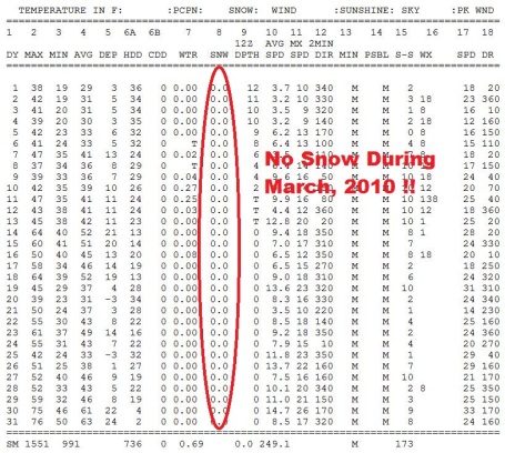 A Snowless March
. Do you remember how amazing March, 2010 was? No snow - there may have been a few flakes, but no official accumulation in the Twin Cities. Highs topped 60 by mid month, mid 70s by the end of March! It was a fast-foward spring last March. Somehow I don't think we'll be quite as lucky this year.
March Numbers. Just how bored are you? I know - it LOOKS like you're busy. Keep your head down and keep on "crunching those numbers". OK. Some good news: by the end of this month the average high in the Twin Cities is a balmy 49 degrees. A shred of hope, coming during the snowiest winter in nearly 20 years. Click
here to see March climate data from the Minnesota Climate Office.
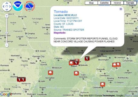
Damage, Outages Reported After Severe Storms Hit The St. Louis Area. Here is an
update from STLtoday.com: "
Severe storms and possible tornadoes slammed into the St. Louis area late Sunday night, causing widespread reports of damage. Winds up to 70 mph blew through the area. According to the National Weather Service, at least three tornadoes were reported — at 11:14 p.m., a tornado was spotted five miles northeast of Gray Summit and at least one home was damaged near St. Albans; a funnel cloud was reported near Concord Village at 11:27 p.m., causing power flashes; and a tornado in Shobonier, Ill., northeast of Carlyle Lake, at 12:20 a.m. damaged two homes."
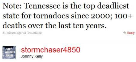 A Surprising Statistic
. This stat really surprised me:
Tennessee the deadliest state in the USA for tornadoes? I would have thought it would be Oklahoma or Kansas, or even Texas. One problem:
many of the twisters that touch down on Tennesse arrive during the nighttime hours. Hilly terrain makes it much harder for storm chasers to track tornadoes. I also think the local population isn't as "tornado-aware" as locals living on the Great Plains, in the traditional heart of Tornado Alley.
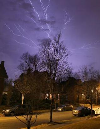
Experimental Storm Tracking. The San Diego office of the National Weather Service has created a great way to track severe weather - plotting reports on an
interactive Google map. The latest severe weather outbreak has spawned over 4 dozen tornadoes since late Sunday.
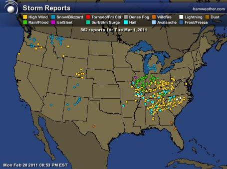 Signs of Spring
. The Gold Package from Ham Weather shows (interactive) storm reports. Over the last 24 hours there have been nearly 100 reports of high winds, tornadoes and severe flooding from Illionis to Georgia and the Dakotas.
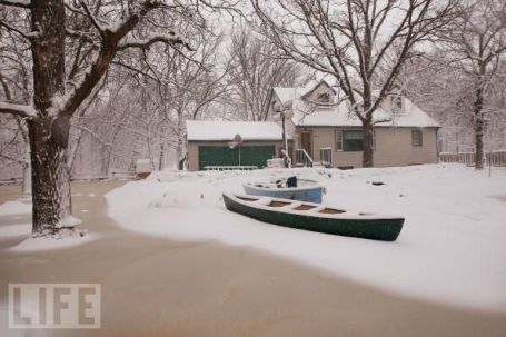
A Soggy, (Snowy) March? (photo courtesy of Life Magazine). Jeremy Nelson from WISN-TV in Milwaukee uses cycles in the atmosphere, "Lezak's Recurring Cycles" to make (daring) long-range predictions. Jeremy is predicting a snowier than average March for southeastern Wisconsin - he's going out on a limb and predicting a major storm between March 22-24, one that could (in theory) impact Minnesota as well. Weather is cyclical (no question about that), but I don't have enough confidence or experience with Lezak Cycles to weigh in on this one way or another. Just passing it on. Read more about what March may hold across the Upper Midwest
here. "
While predicting another record smashing storm is tough. The ‘signature’ storm should return around March 22-24 and I am expecting a classic Spring storm with a severe weather outbreak in the warm sector, and a major winter storm in the cold sector. Each time through the cycle over a half inch of liquid precipitation has been measured. This is one of the wettest storms in this year’s pattern."
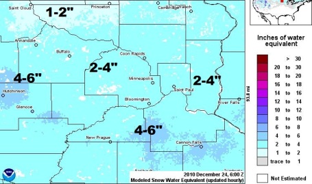 Snow Water Equivalent
. This is one (of many) factors that have hydrologists, river forecasters, so concerned. Soil moisture is in the 99 percentile (as wet as it ever gets). And based on experimental NOAA products there is 2-4" of liquid water in the snow across most of the metro, but closer to 4-6" from parts of Scott and Dakota county westward to Hutchinson and Glencoe.
Weather Alert. A timely
editorial from North Carolina's News Observer: "
A resolution that has cleared the U.S. House and is under consideration by the Senate proposes cutting National Weather Service (NWS) funding by a stunning 30 percent! While every organization must cut back to combat our debt crisis, a cut of this magnitude could have serious negative consequences on our daily lives. Rolling closures of NWS offices could force nearby offices to cover much larger areas with already reduced staff. Thousands could be put at risk if a radar fails at a closed office and prevents forecasters from warning for a developing tornado. Atmospheric observations could be cut back, decreasing the accuracy of computer models that are essential tools for NWS and television meteorologists alike. Even the National Hurricane Center could be affected. Bottom line: these cuts could set the entire field of meteorology back by decades and make it harder for the NWS to issue warnings with enough lead-time to protect the public."
PBS Faces New Threat In Federal Budget. An
article from the New York Times: "
In 1995, Newt Gingrich, then the speaker of the House, failed in his attempt to eliminate federal financing for public broadcasting, thwarted by the timely appearance of “Sesame Street” characters and by panicked supporters who filed petitions and flooded Congressional offices with calls....Mike Riksen, NPR’s vice president of policy and representation, told member stations in January that a confluence of events — the growing deficit, questions about the role of the government in media, budget concerns on both sides of the political isle and in both houses, objections to a perceived left-wing bias — had created “the most determined, organized and sophisticated challenge to federal funding for public radio — ever.”
Why Save PBS? I admit - I'm a big fan of PBS. Not sure what I'd do without shows like "Almanac", "Nova" and "Frontline". I've also gotten hooked on the New Hour with Jim Lehrer every weeknight at 6 pm, one of the few, substantive, hourlong national news shows out there. Where would parents be without Sesame Street? PBS is getting squeezed from every direction, it seems. From Chris Bishop, Creative Director for PBS Kids: "
WHY SAVE PBS? On Saturday, February 19th, the House of Representatives voted 235-189 to pass a continuing resolution that eliminates funding for public broadcasting. I put together this handy chart on why PBS is worth saving. Find out how you can fight back at 170 Million Americans. FULL DISCLOSURE: I am Creative Director for PBS KIDS but a life-long supporter/watcher of PBS ;)"
UPDATE: The infographic is officially on the PBS site now:
http://www.pbs.org/about/save-pbs/
"It Was A Nightmare For Me" - The Madoff Tapes. O.K. This has absolutely
nothing to do with weather or climate or technology, but it's a relatively slow weather-day, and from time to time I like to include stories that catch my eye, above and beyond anything to do with meteorology. New York Magazine just landed an exclusive interview with Bernard Madoff, the man behind a $65 billion ponzi scheme. Is this guy really a monster, a sociopath, delusional? You decide. It's a long article, but a worthy
read: "
Bernard L. Madoff is in therapy. Each week, he waits for the signal that prisoners are allowed to leave their housing units, then he walks the five minutes from his “room,” as he calls it, to the psychiatric unit at the Federal Correctional Institution in Butner, North Carolina, where he can unburden himself. The sessions are often teary. “How could I have done this?” he asks. “I was making a lot of money. I didn’t need the money. [Am I] a flawed character?” In some ways, Madoff has not tried to evade blame. He has made a full confession, telling me again and again that nothing justifies what he did. And yet, for Madoff, that doesn’t settle the matter. He feels misunderstood. He can’t bear the thought that people think he’s evil. “I’m not the kind of person I’m being portrayed as,” he told me. And so, sitting alone with his therapist, in the prison khakis he irons himself, he seeks reassurance. “Everybody on the outside kept claiming I was a sociopath,” Madoff told her one day. “I asked her, ‘Am I a sociopath?’ ” He waited expectantly, his eyelids squeezing open and shut, that famous tic. “She said, ‘You’re absolutely not a sociopath. You have morals. You have remorse.’ ” Madoff paused as he related this. His voice settled. He said to me, “I am a good person.”There aren’t many who would agree. For most of the world, Bernie Madoff is a monster; he betrayed thousands of investors, bankrupted charities and hedge funds. On paper, his Ponzi scheme lost nearly $65 billion; the effects spread across five continents. And he brought down his own family with him, a more intimate kind of betrayal."
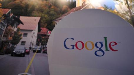
Google Declares War On Content Farms. Hopefully this new development will limit the amount of spam and useless "filler" articles when you do a Google search. An
article from CNN and Mashable.com: "
Google has announced a major algorithmic change to its search engine, subtle in nature and perhaps unnoticeable to many users, but one that should dramatically improve the quality of Google's search results. With this move, Google is targeting content farms -- a common name for low quality sites whose main goal is to attract search traffic by piling up (mostly) useless content, usually by either producing large amounts of low-quality text or by copying it from websites with original content. Google does not go into details of the change which should impact 11.8 percent of Google's queries (currently only in the U.S., with plans to roll it out elsewhere over time), but it does say that it will affect the ranking of many sites on the web."
 What Are The World's Worst Dictators Most Scared Of?
 Simple question. Easy answer:
the Internet. Facebook. Twitter. Their people actually connecting with other people and sharing their gripes, grievances, and hopes.
More from Gizmodo here.
 A Brisk Monday
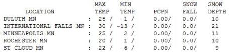
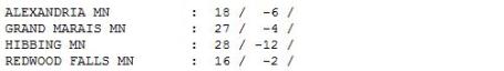
. Under a brilliant sun (with a sun angle as high in the southern sky as it was back on October October 12) the mercury only reached 25 in the Twin Cities, 22 at St. Cloud and 18 in Alexandria. Why was International Falls warmer at 30 F? Probably the presence of so many pine trees nearby. Pine trees are darker, they don't reflect as much sunlight back into space. This lower "albedo" means more warming - temperatures in the North Woods are often warmer during late winter on a bright, sunny day.
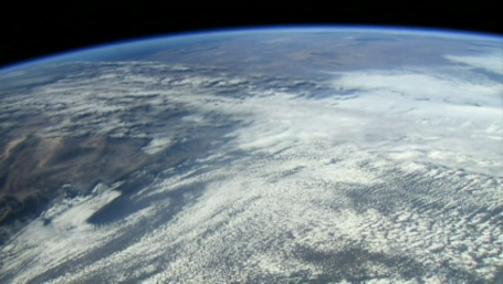
 Severe Clear
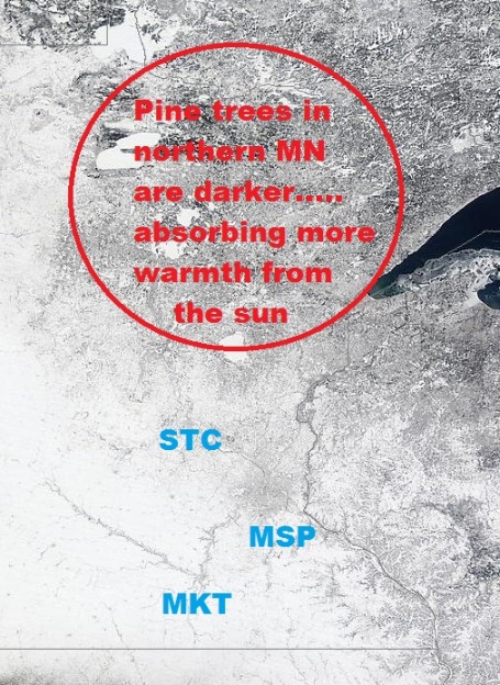
. NASA's MODIS "Terra" satellite in low-orbit across the USA captured a crystal-clear shot of Minnesota Monday. You can clearly see the darker shading to the landscape over northern Minnesota, pine trees appear darker from space - lower albedo absorbing more warmth from the suun, keeping temperatures a few degrees warmer.
 Paul's Conservation Minnesota Outlook for the Twin Cities and all of Minnesota:
TODAY: Sunshine, hints of spring. Winds: W 10-15. High: 35
TUESDAY NIGHT: Windy, turning much colder. Low: 2
WEDNESDAY: Blue sky, January relapse wiht a cold wind. High: 16
THURSDAY: Slushy snow, 1-3" possible. Low: 11. High: 32
FRIDAY: Clouds increase, nighttime flurries. Low: 25. High: 33
SATURDAY: Clouds and flurries linger, coating of slush? Low: 12. High: 28
SUNDAY: Light snow PM hours, an inch or so of slush possible. Low: 13. High: 29
MONDAY: Heavier wet snow possible. Low: 17. High: 28
Hello March!
Welcome to March, the start of "meteorological spring", an awkward transition-month where we'll most likely go from drifts to mud to flooding, average highs near 50 by March 31. "If we could cancel those hockey and basketball tournaments - maybe the weather would simmer down," a friend e-mailed. Maybe not. Up until recently March was the snowiest month of the year for most of Minnesota.
The new data set (1971-2000) now gives January that unique honor, with an average of 13.5" (we picked up 17"). March runs a close second now, with 10.4". Before you hurl yourself off a towering snow drift, there is a huge difference between January snow and March slush. January snow doesn't melt, it just keeps piling up. With a sun angle as high as it was in mid October March snows often melt within a day or two. They're more aggravating than debilitating.
Quiet weather lingers through midweek, today's welcome thaw replaced by a jab of January-like cold tomorrow. We're still on track for a couple inches of slush Thursday (2-4"), more slush late Sunday. Long-range models are hinting at a more significant snow event Monday/Tuesday of next week, maybe enough to shovel and plow. Ugh. Details at my blog.
Barack Obama May Be Forced To Delay US Climate Action. A
story from the U.K. Guardian: "
Barack Obama may be forced to order a two-year delay in Environmental Protection Agency (EPA) action on climate change to try to avoid a complete government shutdown, an environmental conference has been warned. President Obama faces the prospect of a government shutdown by 4 March, with a funding gap leading to federal employees being sent home and government services temporarily closing down, unless he can reach a deal with Congress Republicans who are demanding a crippling $61bn (£38bn) in budget cuts. The house will begin debate on the spending bill on Tuesday following efforts at the weekend to avoid a government shutdown, with news reports suggesting Republicans might compromise on some of the cuts."
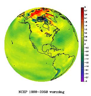
The Deniers Were Half-Right: The Met Office Hadley Center Had Flawed Data, But It Caused Them To Underestimate The Rate Of Recent Global Warming. This probably won't make the professional deniers very happy. The data set may have been flawed, but it appears the the rate of sea surface warming was UNDERestimated. From an
artlcle at Climate Progress: "
Claims that global warming has slowed down over the past decade were partly based on faulty data. Instead, the rate of global warming was underestimated because of a new way of measuring sea-surface temperatures, suggests a new study….[Lead author John] Kennedy says the underestimation of the change in sea-surface temperature could account for up to 0.03 °C of the apparent slowdown in global temperatures. The correction could mean that 2010 will be the warmest year on record, surpassing 1998 and 2005. That’s the New Scientist reporting on a new re-analysis of the global sea-surface temperature (SST) dataset by the Met Office. Of course, everybody but the anti-science disinformers have known for a long time that the Hadley/CRU (Climatic Research Unit) temperature data UNDERestimates — not OVERestimates — the recent global temperature rise. Their data excludes “the place on Earth that has been warming fastest” (see “Why are Hadley and CRU withholding vital climate data from the public?” and “What exactly is polar amplification and why does it matter?“). NASA’s James Hansen has made this point for years."
The Limits Of Doubt-Mongering. "FUD". Fear. Uncertainty. Doubt. Instead of working on viable, cost-effective strategies to move away from carbon-based fuels and gain some level of energy independence, many lawmakers are now (vocally) questioning climate science. From an
article at The Hill's Congress Blog: "
Since Congress re-convened, it seems especially fashionable among the new leadership to voice doubt about the scientific evidence that heat-trapping gases are dangerously warming the planet. And at least one congressman says he will hold hearings into climate science, giving a platform both to mainstream scientists who have spent their professional lives studying the issue, and the relative minority of Ph.D.s in a variety of disciplines who claim climate change is nothing to worry about. That seems reasonable enough at first blush. But rhetoric heard on the campaign trail in the fall and on Capitol Hill since then suggests that the aim might not be to have a serious conversation about the risks we face from unabated warming, or the opportunities for the U.S. to develop the technology necessary to solve the problem. Rather, the goal will be to continue a long-standing campaign to sow doubt about the science, and to tarnish the reputations of our nation’s leading climate scientists - in other words, to deny the problem rather than to solve it. Casting doubt about mainstream scientific findings that upset powerful financial interests – from the health risks of tobacco to the reality and risks of global warming - is a tactic that has been used time and again to delay or avoid regulation. But those getting ready to use it this time should remember that it can backfire."


No comments:
Post a Comment