76.5" winter snowfall so far at MSP.
11" snow on the ground as of Tuesday evening.
41 F. high temperature Tuesday in the Twin Cities (at exactly 12:31 pm)
34 F. average high in the Twin Cities for March 1.
17 subzero nights so far this winter.
28 average number of subzero nights during an entire winter season.
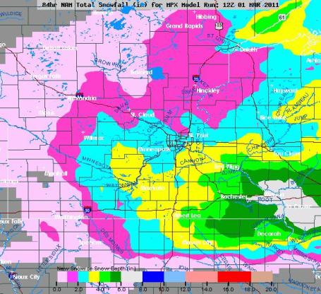
Thursday "Snow Event". I hesitate calling 2" of snow a "storm", but if it's enough flakes to tie up the Crosstown Expressway, maybe it fits the definition. The best chance of a "plowable" snowfall will come south and east of the Twin Cities, the NAM model hinting at some 3-6" amounts east of Rochester, toward Winona, Lake City and La Crosse.
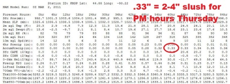
Probably Plowable. Thursday's snowfall will be a nuisance, a few inches of (slushy) snow, many freeways wet and slushy, but people will be getting around. Expect slower commutes, but it won't be a big deal. The latest NAM model increases precipitation to .33, which could fall as 2-4" of snow.
Minor League - Major League? A few inches will fall on Thursday but I don't expect major disruptions. Next Tuesday may be a different story. As much as everyone wants ironclad, airtight predictions about when...and how much....the honest answer is it's still way too early to get specific. The storm is still 6 days away, a lot can (and probably will) change between now and Tuesday. Every subsequent computer run should give us an incrementally more accurate picture of what should happen, confidence obviously increases as we get closer to the event. Suffice to say that there is a "potential for a major snowstorm Tuesday of next week", enough to complicate commutes and long-distance travel plans. Beyond that we simply don't know. Odds favor enough cold air in place for mostly-snow, but the track will determine whether we get a couple inches, or a foot. Will it be a "perfect" track, from Des Moines to La Crosse to Wausau? Or will the storm track farther south, dumping the heaviest snow on Iowa and southern Wisconsin? Too early to tell, but the way this winter is rolling out NOTHING would shock me, certainly not a foot of snow on March 8.
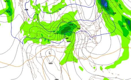
Meteorologists call major storms "bombs". Not sure why, perhaps it has something to do with the fact that most of us are GEEKS, and don't know any better. "Bombogenesis" refers to extremely rapid strengthening of a low pressure system. Next Tuesday evening at 7 pm the GFS has a potential bomb centered over Des Moines, on a track that would favor potentially heavy snow for much of southern and central Minnesota. Again, expect this forecast to change (multiple times) over the coming days, but there's a least a chance of a very significant pile of new snow next week. At the rate we're going nothing would shock me, not even a foot of snow on March 8.
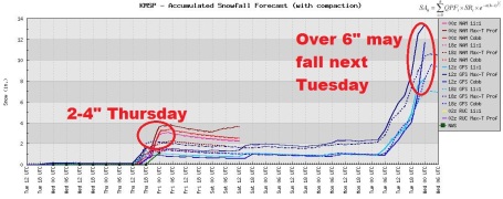
Cringe-Worthy Numbers. It's a long way off (6 days and counting), but the latest GFS model is printing out over 1" of liquid water next Tuesday, with snow estimates over 1 foot. We'll see - there's an awful lot that can happen between now and Tuesday. But you've been warned...
Winter Just Doesn't Want To Let Go. The latest (00z) GFS model brings another cold surge into town after March 11, maybe 1 or 2 nights below zero around March 12-13. The good news: the sun is too high in the southern sky for any bitter cold to linger for long. The models continue to suggest a warming trend after March 15, the start of what may be the long awaited Big Melt. We'll see.
| Year | March 1 (max/min, precip, max wind speed) | March 31 (max/min, precip, max wind speed) |
| | | |
| 2010 | 38/19, 0.00", 10 mph | 76/50, 0.00", 17 mph |
| 2009 | 16/-1, 0.00", 15 mph | 46/33, 0.37" (water)/0.5" (snow), 28 mph |
| 2008 | 30/10, 0.00", 17 mph | 38/29, 0.72" (water)/5.5" (snow), 26 mph |
| 2007 | 33/24, 0.90" (water)/9" (snow), 24 mph | 49/41, 0.72" (water), 21 mph |
| 2006 | 44/31, 0.00", 23 mph | 53/39, 0.05" (water), 25 mph |
| 2005 | 23/9, 0.00", 14 mph | 57/39, T (water), 23 mph |
| 2004 | 44/38, 0.01" (water), 15 mph | 48/24, 0.00", 12 mph |
| 2003 | 42/15, T, 23 mph | 56/31, T, 23 mph |
| 2002 | 16/3, 0.00", 16 mph | 35/26, T, 20 mph |
| 2001 | 31/13, 0.00", 13 mph | 42/29, 0.29" (water), 20 mph |
In Like A Lamb, Out Like A Lion? Does the old adage really work? Any science behind that "old husband's tale"? Meteorologist D.J. Kayser, a student at St. Cloud State University, crunched the numbers and came up with this spreadsheet for the Twin Cities. There seems to be some correlation roughly half the Marches since 2001. 50/50. Sounds about what I'd expect. Bottom line: it works some years (since 2001). Other years: not so much. Thanks D.J.!
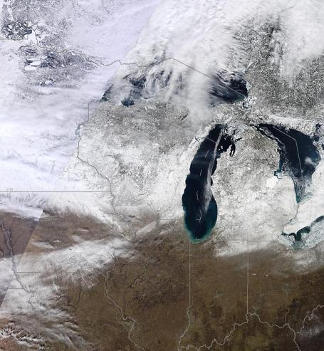
Going Nowhere Fast. From NASA's "MODIS"
Terra satellite on Tuesday it's easy to see who still has significant snow on the ground, very little snow left south of a line from Waterloo, Iowa to Rockford, Chicago and South Bend. It's going fast, but I don't see any prolonged chance for significant melting until the third week of March, at the earliest. Yes, count on a few more good weeks on area snowmobile trails. I have a hunch ice will come off area lakes unusually late this spring.
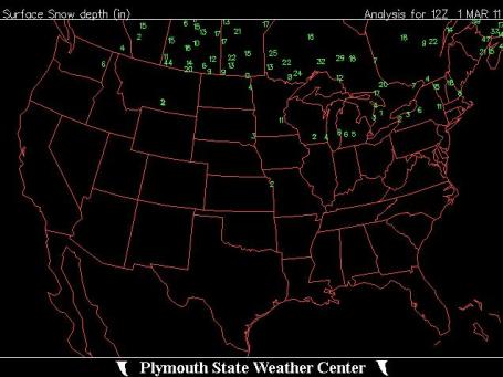
Current USA Snowcover. This is hard to read (sorry for the eye exam). Click
here and scroll down to "snowcover" for the full-screen version, direct from the Plymouth State Weather Center. Not enough snow to measure in Chicago, Milwaukee has 4" of dirty snow, only 2" in Madison. Farther east Buffalo is down to 2", with 11" at Albany, New York.
Look Back At February. Must we? I know - it was a partly-painful month. The meteorologists at
Planalytics (a partner and client of WeatherNation) outside Philadelphia have put together a good summary of some of the weather highs and lows. Mostly lows:
- The first week of the month was the coldest start to February in 5 years with above normal rain and the most snow in over 18 years as the ‘Groundhog Day’ storm impacted most of N. America. Chicago received over 20 inches of snow, its 3rd largest snow event in city history.
- Week 2 was the coldest 2nd week since 1995 and driest since 2002 but with near typical snowfall.
- Ice and winter precipitation reached the Plains and South in weeks 1 and 2. Oklahoma City, Dallas and other cities in the South experienced ice and snowfall bringing traffic and commerce to a halt for several days around Super Bowl weekend.
- A pattern change made week 3 the warmest since 1996, with the least amount of snowfall since 2004. Temperatures in interior locations trended significantly warmer from the prior week.
- Week 4 continued the warmer trend in the Southern Tier, while the Mountain and North Central regions returned to wintry weather with snow and cold temperatures.
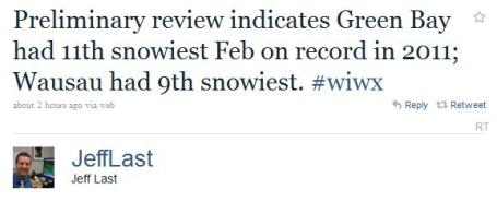
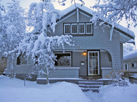
. The UCS, the Union of Concerned Scientists, released this
story on Tuesday: "
Global warming is “loading the dice” to increase the frequency of record-setting snowstorms like those that have pounded the United States and Europe the past two winters, according to scientists participating in a telephone press conference held today by the Union of Concerned Scientists (UCS). “Heavy snowstorms are not inconsistent with a warming planet,” said Jeff Masters, director of meteorology for the Weather Underground website. “In fact, as the Earth gets warmer and more moisture gets absorbed into the atmosphere, we are steadily loading the dice in favor of more extreme storms in all seasons, capable of causing greater impacts on society.” Masters pointed out that in each of the past two winters the northeastern United States has been hammered by three snowstorms that qualified as Category 3 storms or worse on the Northeast Snowfall Impact Scale. That has happened only one other time in the past 50 years—during the winter of 1960-1961. This winter and last, New York City experienced its two snowiest months on record—February 2010 (36.9 inches) and January 2011 (36 inches)—and Philadelphia experienced four of the top 10 snowstorms in its history. In the Midwest, Chicago was hit by its third biggest snowstorm on record early this February and Minnesota, South Dakota and North Dakota all have suffered through near-record snows this winter."
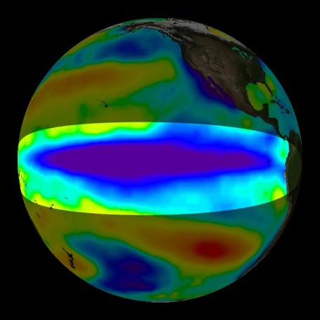
La Nina Finally Shows Signs Of Weakening. An
update from NOAA:
"Nearly all of the ENSO model forecasts weaken La Niña in the coming months (Fig. 6). A majority of the models predict a return to ENSO-neutral conditions by May-June-July 2011, although some models persist a weaker La Niña into the Northern Hemisphere summer 2011. Recent trends in the observations and models do not offer many hints on which outcome is more likely. Also, model skill is historically at a minimum during the Northern Hemisphere spring (the “spring barrier”). Therefore La Niña is expected to weaken during the next several months, with ENSO-neutral or La Niña conditions equally likely during May-June 2011."
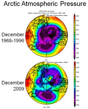
Warm Arctic. Cold Continents. Changes In The Arctic Are Hitting Closer To Home. Here's the
latest from NOAA: "
Extremely cold winds have swept down through the Northern Hemisphere recently, reaching as far south as the state of Florida and causing record low temperatures in January. The unusually cold winter of 2009–2010 – which saw massive snowstorms dubbed “Snowpocalypse” and “Snowmageddon” — and the frigid start to 2011 in the eastern United States and Europe have scientists talking about what might be influencing the weather. Dr. James Overland, a scientist at NOAA’s Pacific Marine Environmental Laboratory (PMEL) in Seattle, has been studying the changing conditions in the Arctic for 30 years. He explains why the deterioration of the Polar Vortex could be leading to some of these extreme winter weather events.“When the Polar Vortex — a ring of winds circling the Arctic — breaks down, this allows cold air to spill south, affecting the eastern United States and other regions,” says Dr. Overland. “This can result in a warmer-than-average Arctic region and colder temperatures that may include severe winter weather events on the North American and European continents.”
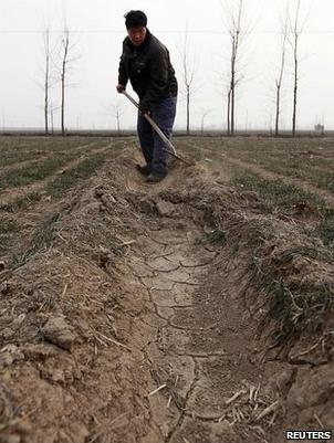
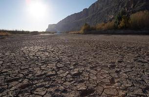
China Drought Worsens In Parched North. The price of wheat is almost guaranteed to go up in 2011; one of the big factors is a worsening drought in northern China. Here's an excerpt from a BBC
article: "
Some 200 million people live across the north China plain. It is home to giant cities like Beijing and Tianjin which are expanding fast. But the area has water resources comparable to a desert country and every year as the population swells the water stress grows worse. "China's industries are inefficient, they consume far more water than those in developed countries. The country's construction boom means water use is even more intensive. Many of the rivers in the north have dried up. Dams have blocked their normal flow, the water diverted to towns, farms and factories. The northern megacities now rely on underground water sources for two-thirds of their needs. But the aquifers beneath places like Beijing are being drained, sinking as they are used faster than the rain can replenish them. Some fear the water could be gone in 30 years in places. Ma Jun is one of China's most prominent environmentalists. Over a decade ago he wrote a book titled China's Water Crisis. As we walk along one of Beijing's dirty canals he tells me: "In China two-thirds of our cities are short of water."
Inland Homeowners In Path Of Higher Hurricane-Insurance Costs. Hurricane warnings are usually issued for coastal counties, but recent research suggests that hurricane damage (wind and flooding rains) can extend as much as 200 to 300 miles inland or more. It turns out coastal residents may be paying too much, while people living several counties inland aren't paying enough (to reflect the greater risk to life and property hundreds of miles away from the coast). The Wall Street Journal has a good
overview: "
A disaster-modeling company that helps insurers predict the cost of storms and earthquakes is rolling out a new hurricane model that will likely boost the price of insurance for some homeowners living a hundred miles, or even 200 miles, from the nearest ocean. Property coverage is typically more expensive for the homes along the East Coast and the Gulf of Mexico that have a front-row seat when a hurricane blows ashore. However, the adjustments being made by the modeling company, Risk Management Solutions Inc., could actually give some of those coastal homeowners a slight break, while increasing the estimates for how much damage a hurricane can do farther inland. While the potential costs for inland homeowners aren’t yet clear, there is consensus in the industry that some of the insurers that use the model will have to raise prices as they re-evaluate their capital levels. Also, some insurers may choose to sell less coverage in areas that are judged by RMS to be more vulnerable than previously thought, also putting upward pressure on prices."
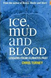
"Ice, Blood and Mud: Lessons From Climate Past" This fascinating look at past (extreme) swings in climate ($16.79 at
Amazon, and no, I don't get a cut) is loaded with eye-opening facts and figures from author Chris Turney. In the January
BAMS, Bulletin of the American Meteorologica Society, the book is reviewed by University of Texas geophysicist Charles Jackson, who writes: "
The style of the book is casual and entertaining. For instance, as part of an explanation of the differences between weather and climate, Turney writes about the origin of the term "weather forecast". This term apparently was first coined by Robert Fitzroy, who in 1854, after being captain of the HMS Beagle voyages that inspired Charles Darwin to write Origin of the Species, was appointed to be the first head of the British Meteorological Office. The forecasts from this office received so much negative publicity that Fitzroy took his own life, and shortly thereafter the forecasts were discontinued for a decade."
(I did not know this, neither the origin of the term "weather forecast", or the public backlash against the mere
attempt to predict the weather - so severe it caused the top guy at the U.K. weather service to take his own life, and forced the British government to wait another decade before trying again. Good grief).
Best Inventions of 2010. Time Magazine has a good
overview of some of the most innovative ideas of 2010. Yes, the iPad made the list, along with a flying car. It's 2011 already - where' my flying car, and robotic butler? I'm waiting patiently.
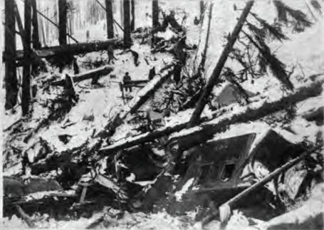
On This Date In History. "MARCH 1ST, 1910-The deadliest avalanche of record in the U.S. thundered down the mountains near Wellington Station WA sweeping three huge locomotive train engines and some passenger cars, snowbound on the grade leading to Stevens Pass, over the side and into a canyon, and burying them under tons of snow. The avalanche claimed the lives of more than 100 people. The station house at Wellington was also swept away." (source:
myforecast.com) For more information click
here to read the Wikipedia account of this disaster.
Paul's Conservation Minnesota Outlook for the Twin Cities and all of Minnesota:
TODAY: Sunny. Who turned off the heat? Winds: N 5-10. Low: 0. High: 13
WEDNESDAY NIGHT: Clouds increase. Low: 10
THURSDAY: Potential for an inch or two of slushy snow. Low: 10. high: near 30
FRIDAY: Sunny start, clouds increase. Fleeting thaw. Low: 20. High: 35
SATURDAY: Flurries, heavier snow stays south. Low: 19. High: 28
SUNDAY: Plenty of sun, good travel. Low: 12. High: 26
MONDAY: Light snow and flurries. Low; 15. High: 29
TUESDAY: Snow. Potential for a big dumping. Low: 17. High: near 30
A 100 Inch Winter?
Meteorologist Andy Revering (who runs a great web site, f5data.com) thinks there's a good chance of topping 100" by late April. "It's not guaranteed, but we seem to be in an exceptionally snowy pattern coming up." Andy's not alone. Jeremy Nelson, a meteorologist for WISN-TV in Milwaukee, uses "Lezak Cycles" to make daring, and surprising accurate, long-range predictions. He's forecasting an unusually wet and stormy March.
What a difference a year makes: we saw NO snow in March, 2010. Another 20" and we'll be close to the all-time record of 98.6", during the (forgettable) Winter of 1983-84. Don't retire the snow blower just yet. A couple inches of slush may fall Thursday, a major storm passing just south of Minnesota grazes southern Minnesota with a light accumulation this weekend.
It gets really interesting next Tuesday, when a storm is forecast to pass just south and east of town. The GFS model prints out over 1" liquid; if it verifies (still a huge "if") we could wind up with 10-12" very close to home. It's been a wild and snowy winter; why should March be any different? Iced sunshine today gives way to a Friday thaw, maybe a streak of 30s after March 14. We're due.
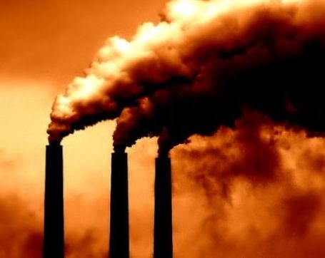
China Issues Warning On Climate Change. I was in China on a vacation a few years ago, decided to rent a bike and see the bucolic countryside. Bad idea. We battled a steady stream of monster-trucks, each one belching black smoke. It was hard to breathe. China is rapidly discovering that it's remarkable growth in the last 10-20 years has come at a steep cost to the environment. China has no equivalent to the EPA, but that will probably have to change in the years ahead. Here's an excerpt from a New York Times
article: "China’s environment minister on Monday issued an unusually stark warning about the effects of unbridled development on the country’s air, water and soil, saying the nation’s current path could stifle long-term economic growth and feed social instability. In an essay published on the agency’s Web site, the minister, Zhou Shengxian, said the government would take a more aggressive role in determining whether development initiatives contributed to climate change through a new system of risk assessment. Ignoring such risks, Mr. Zhou said, would be perilous. “In China’s thousands of years of civilization, the conflict between humankind and nature has never been as serious as it is today,” he wrote. “The depletion, deterioration and exhaustion of resources and the worsening ecological environment have become bottlenecks and grave impediments to the nation’s economic and social development.”
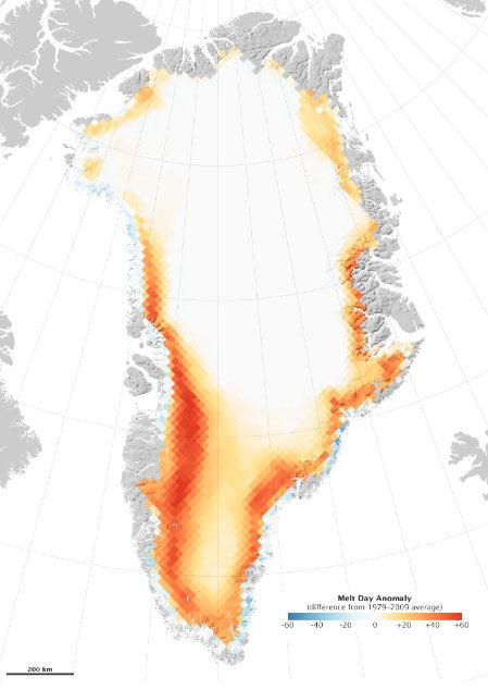
The Big Melt: Greenland Lost More Than A "France-Size" Area Of Ice Last Year. The red/orange-shaded areas above show regions of Greenland with more days of snow melt in 2010. Bottom line: Greenland's melt season in 2010 lasted 50 days longer than average, a statistically significant deviation from "normal". An
article from "Good" and NASA's Earth Observatory: "
The long melt season primarily affected southern and western Greenland, where communities experienced their warmest year on record. After a warm, dry winter, temperatures were particularly high in the spring, getting the melt season off to a strong start. The early melting set the tone for the rest of the season, leading to more melting all the way into mid-September. Marco Tedesco is the City College of New York professor and researcher in the Cryospheric Processes Laboratory responsible for the research. In his post on the record-setting melt, he notes: The increasing melting trend over Greenland can be observed from the figure. Over the past 30 years, the area subject to melting in Greenland has been increasing at a rate of ~ 17,000 Km2/year. This is equivalent to adding a melt-region the size of Washington State every ten years. Or, in alternative, this means that an area of the size of France melted in 2010 which was not melting in 1979."
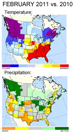
Cold Comfort: Canada's Record-Smashing Mildness.
An update from climate researcher Bob Henson at UCAR in Boulder:"
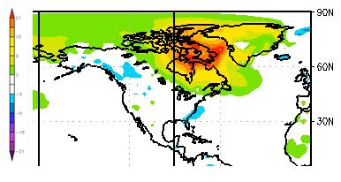
It’s the second chapter of a tale that began a year ago, when Canada as a whole saw the warmest and driest winter in its history. Much of the blame went to El Niño, which typically produces warmer-than-average weather across Canada. So far, so good—but similar things are happening this winter, even with a La Niña now at the helm. Just how mild has it been? The map at right shows departures from average surface temperatures for the period from 17 December 2010 to 15 January 2011, as calculated by NOAA’s Earth Systems Research Laboratory. The blue blip along the southeast U.S. coast indicates readings between 3°C and 6°C (5.4–10.8°F) below average for the 30-day period as a whole. That’s noteworthy—and in fact, it was the coldest December in more than a century of record-keeping across south Florida (see PDF summary). Blue also shows up across the UK, where December averaged 5.2°C (9.4°F) below normal."
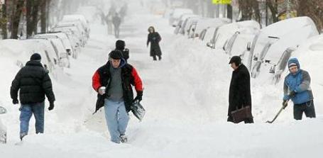
Scientists: Global Warming To Blame For Big U.S. Snowstorms. This is a tough concept for many people to wrap their brains around. How on Earth can a slowly warming atmosphere create the conditions necessary for monster snowstorms? The reality: the slow-motion warming trend has evaporated more ocean water, resulting in a 4-5% increase in water vapor worldwide. Not even the skeptics or "unconvinced" dispute that fact. USA Today picks up the
thread: "
Counterintuitive though it may be, "heavy snowstorms are not inconsistent with a warming planet," says Jeff Masters, director of meteorology for the Weather Underground, a private weather service. The announcement was made at a news conference on Tuesday in Washington, D.C., by the Union of Concerned Scientists, a non-profit environmental group. It was not published in a peer-reviewed study in an academic journal. "The old adage, 'It's too cold to snow,' has some truth to it," said Masters. "A colder atmosphere holds less moisture, limiting the snowfall that can occur." At one point this winter, 49 of the 50 U.S. states were partly or completely snow-covered. Only Florida was snow-free. Yet, while the USA endured unusually heavy snow this winter, thousands of miles north in the Arctic, temperatures were at near-record high levels, according to Mark Serreze, director of the National Snow and Ice Data Center in Boulder, Colo."
Climate Change And The Southwest Water Crisis: Making A Bad Situation Worse. It's been a good winter for moisture (heavy snow) in the west, which will translate into a reliable supply of water for consumer use and agriculture. Here's an excerpt from an
article at grist.com: "
Where and how will climate change first affect large numbers of American voters? Answering that question may be crucial to the global efforts to protect the Earth's climate. The tsunami of stupidity and science denial that has washed over Washington, D.C., won't be held back by earnest calculations of long-run risks, or by the potential inundation of remote island nations, or by the news that polar bears and other iconic species are endangered. While climate change may seem remote, the water crisis in the Southwest is all too immediate. Recent years of drought have reached critical levels, threatening to curtail agriculture and even the normal patterns of urban life throughout the region. Even if today's climate remained unchanged, water use in Arizona, California, Nevada, New Mexico, and Utah would more than double over the next century, just from population and income growth. In a recent study, Elizabeth Stanton and I show that the changing climate will make a bad situation worse, increasing the Southwest's water consumption by an additional one-third of today's level of use. There is simply no way to get that much water; the region's rivers and rainfall aren't going to grow."
North Country Scientists Rewrites History Of Global Climate Change. Curt Stager, a scientists at Paul Smiths College, has just published a paper focused on rapid climate change that transformed Asia and Africa thousands of years ago. "
But in a new paper set to be published next month in the journal Science, Stager argues that he’s found evidence of a massive drought, so big that it literally changed the world. Sixteen thousand years ago, the Monsoons of Asia failed. The Nile and the Congo shriveled up. The great lakes of Africa and the Near East turned to dust. "There would have been nowhere [for tribes of humans] to go," he said. "It would have turned what is now a green part of Africa into a savannah or a desert." Normally this might just sort of be cool information, a time-machine glimpse of the harsh world faced by our ancient ancestors. But Stager’s paper makes one more connection. He says this mega-drought, which lasted for centuries, was likely caused by a natural cycle of global warming, the end of an ice age that melted glaciers and tipped thick ice sheets into the North Atlantic. "
Price Carbon And Spread The Load, Says Climate Chief. Until carbon is correctly priced as a "pollutant" businesses will be operating in the dark, an ongoing risk that needs to be addressed for companies to successfully reinvest in their businesses and move forward. A
story from the Sydney Morning Herald: "
The former United Nations climate change chief has warned Australia not to be ''too radical'' in designing its carbon tax but urged the federal government to proceed with the policy. Yvo de Boer, KPMG's special global adviser on climate change, also questioned the Opposition Leader's vow to repeal the tax if he wins the next election. He said businesses across the world are demanding a bipartisan approach to climate policy. ''I think to be able to reverse something you first have to know what it is,'' he said. ''I don't know what [Tony Abbott] would be reversing. What I hear from companies around the world is huge frustration that whenever an election happens somewhere in the world, policy is altered or reversed."
Shareholder's Call For Climate Change Louder Than Ever. An
article from businessinsider.com: "
According to the study, which was conducted by Ceres, a Boston-based public interest coalition that addresses sustainability challenges, shareholders at companies in the coal, electric and oil sectors filed 41 resolutions, up 50 percent from the number of environmental resolutions filed at such companies last year. The resolutions revolve around issues that can have an impact on business transactions now and in the future. They concern companies’ analysis of the financial risks associated with water scarcity and pollution, and companies’ production of sustainability reports. They also address the sourcing of sustainable palm oil and the use of renewable energy."






No comments:
Post a Comment