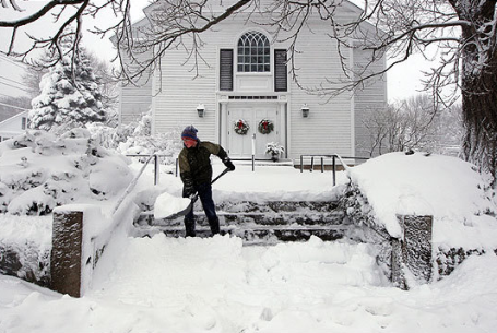
* Travel conditions will get worse as the day goes on. The worst travel will be from late afternoon into Sunday night, when snow may be falling at the rate of 1-2"/hour with considerable blowing and drifting, especially outside the metro.
* Blizzard conditions are likely over southwestern Minnesota, but much of central and southern MN will experience near-blizzard conditions, with sustained winds of 25-30 mph at the height of the storm late this afternoon and tonight, just 5 mph. shy of blizzard criteria. Expect near white-out conditions later today.
* 2-4" snow may fall at the tail-end of the storm Monday morning. The Monday AM commute will still be very slow.
* At the rate we're going, this will probably be one the 5 snowiest Februarys on record. The all-time record for February snow in the cities is 26.5", in February, 1962.

No, It Won't Be Quite This Much Snow. Just when you thought there were true signs of spring on the horizon, along comes a kick in the Doppler, a rude reminder that snow season in Minnesota (in theory) runs from September through early June. If you have to travel today, try to do it first thing Sunday morning.
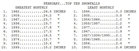
Top 10 February Snowfalls. Not sure we'll break 1962's record of 26.5", but if we do wind up with 12-18" (very possible) and we get a few more inches on Friday - this could be one for the record books. Source: Minnesota State Climatology Office.
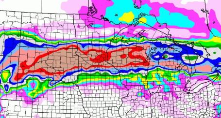
Here We Go Again. After looking at all the data and computer models I have the same feeling I had back on December 9, before we were engulfed in waves of heavy snow which piled up to a depth of 17" in the metro, some 20" amounts in the suburbs. That bright red-shaded area encompassing much of the metro is the 16" band. Good grief.
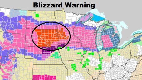
Current Warnings. Blizzard warnings are already posted for much of west central and southwestern Minnesota - the rest of central/southern Minnesota is under a Winter Storm Warning, meaning the storm is pretty much imminent. Ice Storm Warnings are in effect for northern Nebraska and northwestern Iowa for severe glaze icing. Not sure we can dodge this one. For the very latest NWS watches and warnings on an interactive map click here.
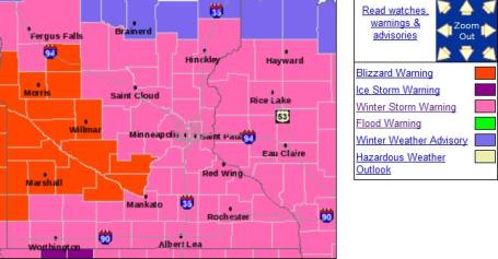
Blizzard Warnings. Those bright red counties (Willmar, Morris, Marshall, Mankato area) are already under blizzard warnings - which MAY be extended into the Twin Cities metro during the day on Sunday as snow (and wind) increases and visibility drops to near zero at times. For the latest from the local NWS office click here.
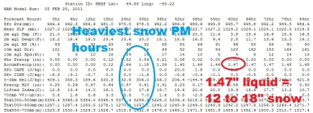
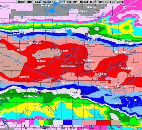
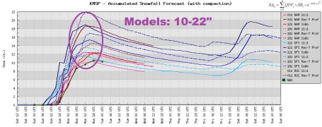
Timing The Heaviest Snow. The 00z NAM model is still showing the heaviest snow falling between about 4 pm and midnight, at the rate of 1-2" an hour at times. The model prints out a total of 1.47" of liquid water. At a snow/rain ratio ranging from 15/1 to 20/1, that should be roughly 12-18" snow for much of the area. Definitely plowable. Borderline crippling, come to think of it.

Near White-Out By Sunday Evening? This is an experimental product from NOAA, showing the probability of visibilities under 1/4 mile at 7 pm Sunday evening as the axis of heavy, windblown snow sets up over central and southern Minnesota.
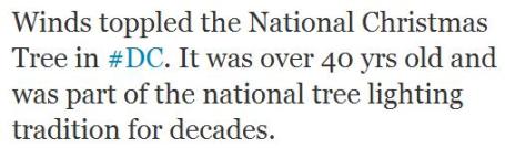

Strong Winds Topple National Christmas Tree. This seems downright un-American. On Sunday winds up and down the east coast gusted as high as 60 mph, a powerful cold front and a strong pressure gradient whipping up powerful, tropical-storm-force gusts that downed trees and powerlines, fanning brushfires in the Washington D.C. area. More from MSNBC: "WASHINGTON — Fierce winds swept through the mid-Atlantic region Saturday, knocking out power to thousands, fanning fires and toppling the National Christmas Tree. More than 100,000 customers lost power in Washington, Maryland, and Virginia at some point Saturday, but power had been restored to most of them by Saturday evening. The National Christmas Tree is a Colorado blue spruce that was planted on the Ellipse, near the White House, in 1978. It was 15 years old and 30 feet tall when it was planted. It's now 47 years old and stood about 42 feet."
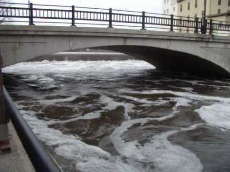
Flood Update. Professor Mark Seeley has the latest on the spring flood outlook in the latest Weather Talk commentary. Here's an excerpt: "Also (last) week the National Weather Service in cooperation with the NOAA North-Central River Forecast Center issued updated hydrologic outlooks for spring flooding. The risk remains quite high (60-98 percent) for moderate to major flooding at all points along the Red River between North Dakota and Minnesota. In addition the risk is high for moderate to major flooding at some points (Montevideo, Mankato, and New Ulm) along the Minnesota and Cottonwood River watersheds. For the Mississippi River above Red Wing the risk is high for major or moderate flooding in St Paul, Hastings, and Red Wing, while high risk is also seen for the Crow River at Delano and high risk for moderate flooding of the St Croix at Stillwater. For further review of the details from the hydrologic outlook please go to our web site and choose a watershed region."
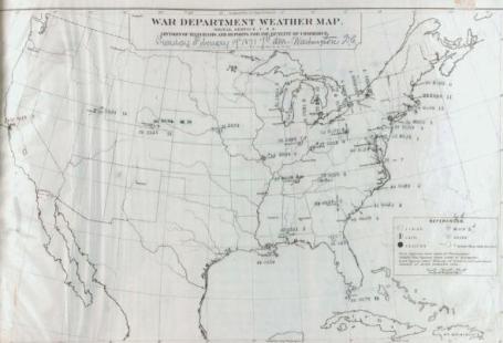
The First Official U.S. Weather Forecast. Here's a fascinating post from alabamawx.com: "On this date in 1871, the War Department’s Signal Service issued the first official weather forecast for the nation.
Synopsis of Weather Report for the last twenty-four hours.
The storm of the 18th, which left the East Atlantic coast last night, was followed by a rapid recovery of pressure and high northwest winds. Today a low barometer has prevailed on the Lakes, gradually giving way to the pressure from the South. A pretty decided increase has taken place in the pressure in the southern States, attended by clear weather and clear winds. Humidity has been small in the North-east and on the Atlantic. A steady pressure , with fair weather, holds in the West, but decided fall is reported from San Francisco."
Cuts To National Weather Service Harmful, Employee Chief Says. This interview with a NWS rep is focused on the Little Rock, Arkansas office of the NWS, but it applies to every office in the nation, including the local Twin Cities office. If these cuts are enacted the result will be a degredation in warnings, and a deterioration in the quality of the data and numerical model output. Put simply: this will impact our ability to gather weather data and predict the weather, including severe, life-threatening storms. Here's an excerpt of an article at Yahoo News: "House Appropriations Chairman Hal Rogers proposed the Continuing Resolution HR 1 this week that threatens funding for the National Weather Service (NWS), a service of the National Oceanic and Atmospheric Association (NOAA), with a budget cut of 30 percent, if passed. National Weather Service Employees Organization (NWSEO) President Dan Sobien, of Little Rock, agreed to follow up on today's press release with an interview. Sobien says that the NWS budget cuts, if enacted, would be "felt in every aspect of daily life," from emergency weather forecasting to the cost of shipping goods. Specific concerns for him include suspended and terminated weather observation activities, such as the potential grounding of the Hurricane Hunter Jet, which helps determine a hurricane's path, to reduced weather balloon launches which may result in less accurate forecasts.
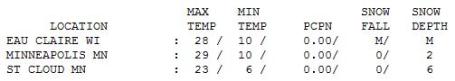
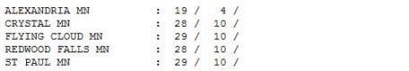
Saturday Numbers. With the sun out much of the day the mercury reached the upper 20s in the Twin Cities, holding at 23 in St. Cloud and 19 at Alexandria. MSP is reporting only 2" snow on the ground. That's about to change...
Paul's Conservation Minnesota Outlook for the Twin Cities and all of Minnesota:
TODAY: Winter Storm Warning, snow gets heavier as the day goes on - treacherous roads by afternoon/evening. Winds: NE 20-30 (near blizzard conditions over parts of central, southwestern and west central MN). High: 26
MONDAY: Snow tapers, 12-18" totals possible across much of the area. High: 21
TUESDAY: Fading sun, better travel statewide. High: 23
WEDNESDAY: Clouds increase, light snow late, little accumulation. High: 32
THURSDAY: More clouds than sun. High: 27
FRIDAY: More snow, a few inches of snow possible. High: 25
SATURDAY: Snow tapers to flurries. High: near 20
Near Blizzard Conditions
No, I don't use the "B-word" lightly. A blizzard is defined as sustained winds of 35 mph and visibilities under 1/4 mile in falling/blowing snow. Southern Minnesota may be close to this criteria by tonight as a powerful storm tracks just south of Minnesota. Get your travel out of the way early; conditions on area highways will get worse as the day goes on.
A major snowfall requires a unique recipe of ingredients: a track south/east of MSP (to prevent a changeover to ice or rain), a slow-moving storm capable of tapping Gulf moisture, and enough cold air in place to keep temperatures in the lowest mile of the atmosphere below 32 F. We should have all those factors with today's storm, and the result may be 12-18" by Monday morning. A few towns over central annd southern MN may see close to 20". It won't be quite as much as fell in December (17.1" on the 10th and 11th) but it may be close. The very worst travel will come tonight, when blowing/drifting may leave roads south of MSP impassable.
Good news: no Arctic air this week; roads should be in pretty good shape for Tuesday's commute. And kids off for President's Day will have a good excuse to disconnect from video games and hit the slopes!
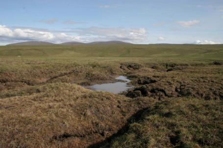
Melting Permafrost To Emit Carbon Equal To Half All Industrial Emissions: Study. Here's a troubling study from the Winnipeg Free Press. If this pans out the models have been (greatly) underestimating the amount of carbon released into the atmosphere. This is a real wild card in the climate discussion - supercomputer simulations usually underestimate these "positive feedbacks", these cyclic loops. If you warm up the permafrost, even a little, you can release vast quantities of stored methane gas, 21 times more powerful than CO2. The truth: we're in uncharted territories, and computer predictions only go so far: "A new study suggests the Arctic is headed for a permafrost meltdown that will release greenhouse gases equal to half the emissions of the entire industrial age. The report, the first to estimate how much carbon will be emitted as the warming Arctic's frozen soil melts, suggests the massive, long-term release will make it even tougher for the world to manage climate change. "This is a lot of carbon," said Kevin Schaefer of the National Snow and Ice Data Center in Boulder, Colo. "Undoubtedly, it will amplify the warming due to fossil fuel emissions." Numerous studies over the past few years have pointed out that permafrost is melting in a warming Arctic. Many have warned that the organic matter in that permafrost will now be free to decay, releasing greenhouse gases. Schaefer's study, published by the International Meteorological Institute in Stockholm, uses computer modelling to estimate how much and when. Within 15-20 years, Schaefer said, enough carbon dioxide and methane will be seeping from soggy permafrost to turn the entire Arctic into a global source of carbon, reversing the region's current status as a carbon sink. Within a century, Canada will have lost about a third of its permafrost. Globally, that meltdown will have released about 95 billion tonnes of carbon. By 2200, somewhere between one-third and two-thirds of the world's permafrost will be gone and that carbon release will have doubled."
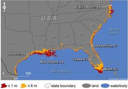
Study: Sea Level Rise To Swamp Coastal Cities by 2100. USA Today has a story about projections of sea level rises in the 21st century. When I talk to groups I mention (only half tongue in cheek) that "if they're seriously considering retiring in Florida to buy a home 2-3 blocks inland from the water....and be patient." An excerpt: ".....yet another climate change report – this one about sea-level rise in the USA – crossed my desk this week. In it, the report states that rising sea levels could threaten 180 U.S. coastal cities by 2100, according to new research led by University of Arizona scientists. The coastal cities the research team identified had 40.5 million people living in them, according to the 2000 U.S. Census. By 2100, that number will certainly be exponentially higher. The report states that the Gulf and southern Atlantic coasts will be particularly hard hit. Miami, New Orleans, Tampa, Fla., and Virginia Beach, Va. could lose more than 10 percent of their land area by 2100 due to sea-level rise. The paper appears in the journal Climatic Change Letters. "With the current rate of greenhouse gas emissions, the projections are that the global average temperature will be 8 degrees warmer than present by 2100," says lead researcher Jeremy L. Weiss, a senior research specialist in the University of Arizona's department of geosciences. "That amount of warming will likely lock us into at least 4 to 6 meters of sea-level rise in subsequent centuries, because parts of the Greenland and Antarctic ice sheets will slowly melt away like a block of ice on the sidewalk in the summertime," Weiss says."

Climate Projections Show Human Health Impacts Possible Within 30 Years. Another eye-opening story from Science Blog: "A panel of scientists speaking today at the annual meeting of the American Association for the Advancement of Science (AAAS) unveiled new research and models demonstrating how climate change could increase exposure and risk of human illness originating from ocean, coastal and Great Lakes ecosystems, with some studies projecting impacts to be felt within 30 years. “With 2010 the wettest year on record and third warmest for sea surface temperatures, NOAA and our partners are working to uncover how a changing climate can affect our health and our prosperity,” said Jane Lubchenco, Ph.D., under secretary of commerce for oceans and atmosphere and NOAA administrator. “These studies and others like it will better equip officials with the necessary information and tools they need to prepare for and prevent risks associated with changing oceans and coasts.” In several studies funded by NOAA’s Oceans and Human Health Initiative, findings shed light on how complex interactions and climate change alterations in sea, land and sky make ocean and freshwater environments more susceptible to toxic algal blooms and proliferation of harmful microbes and bacteria."
No comments:
Post a Comment