* Winter Storm Warnings in effect - Blizzard Warnings for west central and southwestern Minnesota for visibilities near zero in white-out conditions - travel not recommended this afternoon and tonight, especially south/west of the Twin Cities.
* Blizzard Warning in effect until noon Monday west of a line from roughly Alexandria to Willmar to New Ulm.
* This storm will probably drop 12-15" on much of the metro by midday Monday, not quite as much as the 17.1" that fell December 10-11, but in the same ballpark.
* Snow gets heavier/steadier through the afternoon and evening, falling at the rate of 1-2"/hour from late afternoon into early tonight.
* Travel conditions will get progressively worse as the day goes on; sustained winds of 20-30 mph. will result in considerable blowing and drifting of snow with visibilities ranging from 1/4 mile to near zero at times.
* Never (ever) tell a Minnesotan not to drive, but a word to the wise: it's going to be pretty bad out there later today. Even 4-wheel drive won't prevent some dork from T-boning you at an intersection or getting rear-ended because the "guy didn't see you." This storm will rival what we went through on December 10-11, 2010. Lightning may not strike the same place twice (nonsense), but snowstorms do...
* Accumulating snow spills over into midday Monday. My hunch: an additional 2-3" Monday morning. By that time much of the metro should be digging out from under 12-15" snow. A few towns closer to St. Cloud may wind up with 18, even 20".
* Gusty winds will result in some 2-4 foot drifts, especially in open country/fields across central and west central Minnesota.
- As of noon 2" had alread fallen in Minneapolis and Chanhassen, 2.5" at Shakopee. I expect much of the metro to have 6" on the ground by late afternoon, close to a foot by breakfasttime on Monday.
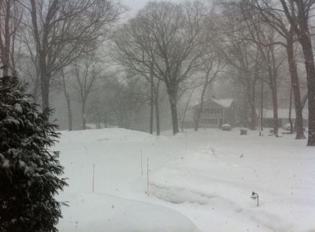
Crosstown On A Bad Day? No, we won't see THIS much snow. But we will probably pick up a foot, with some 2-3 foot drifts outside the downtowns as winds whip up to 30 mph by evening. Travel will go from bad to worse as the day goes on. If you want a cheap (potentially expensive/painful/religiously inspiring) thrill go for a drive later today. You'll wish you hadn't.
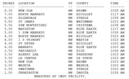
Snowfall So Far. 8" already in New Ulm? That is the definition of heavy snow. As of noon the Mankato area had already picked up 5-7" snow, and that snow is a). falling at the rate of 1-2"/hour, and b). moving into the Twin Cities metro. To see updated amounts from the NWS click here.
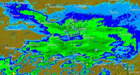
Dopper Radar. This GR3 Analyst snapshot of MPX Doppler was taken at 12:40 pm, showing the east-west axis of moderate to heavy snow setting up right over the metro....flashbacks of the December 10-11 storm, which took a similar track, also tapping moisture from the Gulf of Mexico. I don't think we'll see quite that much snow (17.1") but we may come very, very close. This will almost certainly go down in the books as the second biggest snowfall of winter.
Over A Foot. Assuming an average snow/rain ratio during the duration of our storm of 15/1, or even 18/1, the 1.1" liquid predicted for MSP will probably work out to 14 or 15" for many of us. Not sure how we see anything less than 10", most areas will pick up at least a foot, and closer to St. Cloud I could (easily) envision some 15-20" amounts. Just another day in the park here in Minne-snowda.
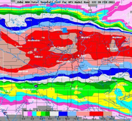
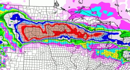
Seeing Red. That bright red-shaded area, engulfing most of the metro area, is 16" snow. Closer to 18-20" is possible just north, toward St. Cloud and the far northern suburbs of the Twin Cities, as well as west of Willmar and Marshall, closer to Morris, Granite Falls and Breckenridge.
Snow Day. If we pick up at least 10" of snow (likely) this winter will go down in the books as the second snowiest winter (to date) since modern-day records were first started in 1891, according to the National Weather Service. The previous 6 winters averaged only 39". Average is closer to 53". I guess we were due for a real winter. Darn La Nina.
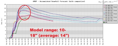
Which Model Do You Believe? It's still a pretty big spread: models printing out anywhere from 10-18" by midday Monday. I still feel fairly confident we'll wind up with 12-15" before the flakes stop flying, but I could see signficantly more than that from the far north metro to St. Cloud and Alexandria.
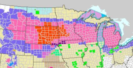
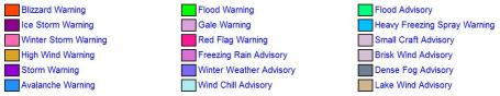
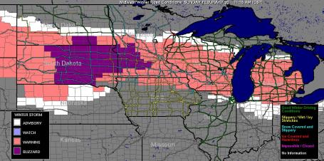
Current Warnings. All those bright red counties west of the metro are under Blizzard Warnings - the rest of the state of Minnesota and most of Wisconsin under Winter Storm Warnings. The latest NWS information is here.
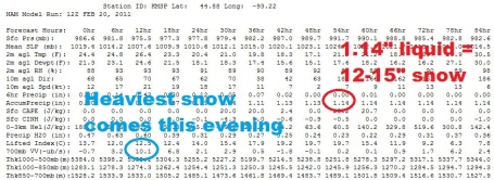
More Numbers. Here is the 12z run of the NAM, probably the most reliable (although the term "reliable weather model" is something of an oxymoron). They all have their strengths and weaknesses - much of meteorology is knowing which models to believe, and when. The NAM shows the most intense upward motion (and heaviest snows) coming this evening, with a total of 1.14" liquid, which should work out to 12-15" or more of snow by midday Monday.
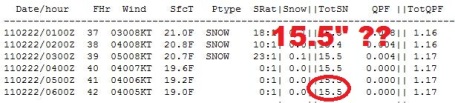
Another Projection. Another model (which factors the projected rain/snow ratio over time as the entire atmosphere over Minnesota gradually cools over the next 24 hours) prints out 15.5" of snow in the Twin Cities by midday Monday. That may be close to the mark - but not every town will see 15". Just about everyone should pick up at least 10" though.
No - We Won't See This Much Snow. Keep in mind: a). it could be worse, b). the bulk of the snow is falling on a weekend (and major holiday), and c). all those companies that rely on snow are happy about the forecast, and d). it's storms like this that will ensure that Minnesota never becomes Chicago (with lakes).
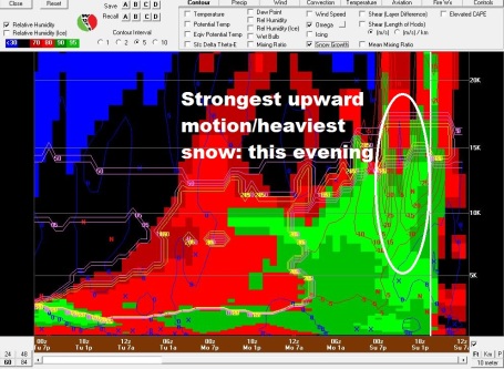
Thunder-Snow? This Bufkit cross-section of the storm (current time is on the right, this map reads from right to left...go figure) shows the most intense upward motion during the afternoon into the evening hours, when the vertical velocities may be strong enough to support snow falling at the rate of 2"/hour (and possibly even some thunder and lightning!)
Going Downhill. Click here to see the latest travel conditions across the Upper Midwest (poor, and getting worse as the afternoon goes on). Data and graphics provided by the University of Wisconsin meteorology department.
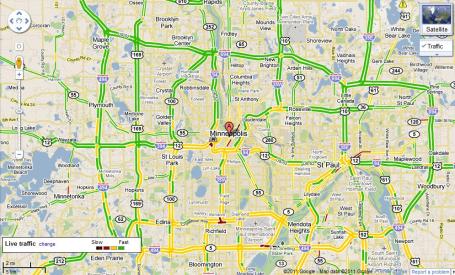
Metro Travel Conditions. Travel is worse on the south side than the north side of the metro, but I expect the entire Twin Cities traffic grid to be a basket case by late afternoon/evening, when the heaviest snows are expected. Click here to see the latest, thanks to our omnipotent, all-knowing friends over at Google.
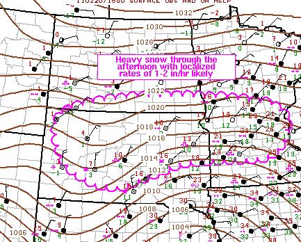
Enhanced Snowfall. According to SPC snow will be falling at the rate of 1-2"/hour from South Dakota into central Minnesota and the Twin Cities through the afternoon. My hunch is that S or S+ may linger into the evening and early nighttime hours as well. For those of you who want more (meteorological) details: "HEAVY SNOWFALL WILL CONTINUE TO DEVELOP/INTENSIFY IN A GENERAL WEST-EAST CORRIDOR ACROSS SD /MAINLY NORTH OF I-90/ AND EXTREME SOUTHERN ND INTO SOUTH-CENTRAL MN INCLUDING THE TWIN CITIES. LOCALIZED SNOWFALL RATES OF 1-2 IN/HR ARE LIKELY...ALONG WITH BLIZZARD CONDITIONS AT TIMES ESPECIALLY ACROSS PORTIONS OF EASTERN SD/SOUTHEAST ND AND SOUTHWEST MN. AS A LEAD SHORTWAVE TROUGH CONTINUES TO PIVOT NORTHEASTWARD OVER THE NORTHERN HIGH PLAINS...CONSIDERABLE DEEP FORCING FOR ASCENT OWING TO DPVA...A COUPLED JET ALOFT...AND STRONG LOW LEVEL WARM ADVECTION/ISENTROPIC LIFT WILL CONTRIBUTE TO A FAVORABLE SCENARIO FOR HEAVY SNOWFALL WITH AN ARCTIC AIRMASS IN PLACE ACROSS THE REGION. WITH SLANTWISE/SOME UPRIGHT CAPE AS EVIDENCED BY ONGOING LIGHTNING THIS MORNING ACROSS FAR SOUTHERN MN/MUCH OF IA...AND STEEP LAPSE RATES/WEAK ELEVATED BUOYANCY NOTED IN UPSTREAM OBSERVED RAOBS SUCH AS 12Z RAPID CITY/NORTH PLATTE...PROXIMITY OF WEAK STATIC STABILITY/STEEPENING LAPSE RATES ALOFT WILL CONTRIBUTE TO ENHANCED SNOWFALL RATES WITH OTHERWISE FAVORABLE THERMODYNAMIC PROFILES FOR AMPLE DENDRITIC/AGGREGATE SNOW GROWTH PER 12Z NAM/RUC FORECAST SOUNDINGS. IN ADDITION...STRONG NORTHEASTERLY WINDS WILL CONTRIBUTE TO BLIZZARD CONDITIONS AT TIMES...ESPECIALLY ACROSS EASTERN SD/SOUTHEAST ND/SOUTHWEST MN TO THE EAST/NORTHEAST OF A DEVELOPING INVERTED SURFACE TROUGH."
(Translation: it's 'gonna snow...hard).
No comments:
Post a Comment