13" fell as of 10 pm Sunday evening in the Twin Cities, bringing the season total up to over 74", making this winter the second snowiest to date. Only 1982 saw more snow as of February 20 (76").
17" measured at Eden Prairie (Flying Cloud Airport) as of 10:30 pm Sunday. Remarkable.
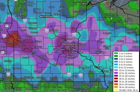
12-18" snow totals are likely from this storm, just a little less than the storm that hit December 10-11, which dumped 17.1" on the Twin Cities. The odds of two 15+" snowfalls in one winter? Probably 1 in 100, possible less than that. A few southern suburbs may wind up with 16-18" snow before the flakes subside later in the day on Monday.
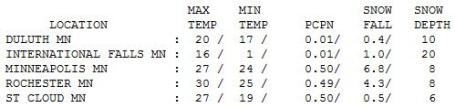
Check out some of these snowfall subtotals as of 10 pm Sunday, courtesy of the National Weather Service:
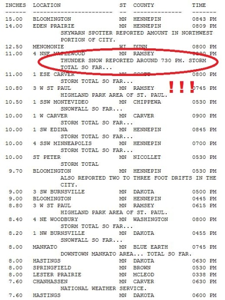
Snow Totals As Of 10 PM Sunday Evening. I thought there would be a lot of snow (not sure if anyone else was stupid enough to predict 12-18" a day before the storm hit) but even I was slightly amazed when the 12" report came in from Minneapolis at 9:30 pm Sunday evening. I've learned (the hard way) that it pays to be conservative predicting snowfall amounts - because more times than not the storm isn't going to work out the way you thought. The models often overestimate snowfall amounts, and believe it or not we don't want to be accused of crying wolf. But I had a feeling that the scenario would wind up being amazingly similar to the December 10-11 storm, with the "deformation zone", the east-west axis of heaviest snow, setting up directly over MSP. Thta's exactly what happened. Yes, lightning struck twice this winter: 2 massive 15"+ storms in one winter - amazing. By the way, there were reports of lightning Sunday evening over southern Minnesota. That's how violently the air was rising and cooling over Minnesota, resulting in snowfall rates of 2-3"/hour at times. These amounts are a moving target - for the latest numbers from the NWS click here.
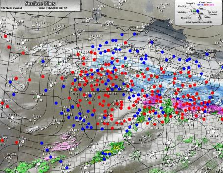
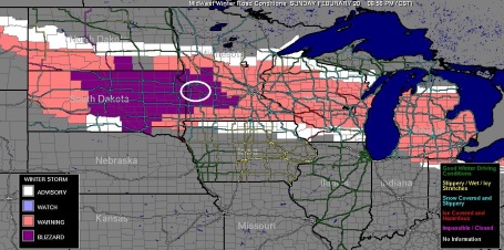
A Stomach-Churning Storm. Check out how narrow that band of snow was Sunday night, only 75-100 miles wide. It set up directly over the metro (as expected), producing some 10-15" snowfall amounts, but St. Cloud missed out on the heaviest snow, as did Rochester. Mankato "only" picked up 8". These are really difficult storms to try and nail, a difference of 25-50 miles in the storm track can make the difference between 4" and 14". The storm impacted thousands of square miles, from central Minnesota and much of Wisconsin to Lower Michigan. Icing was reported from southern Minnesota and northern Iowa into the Madison area. For the latest surface map click here.
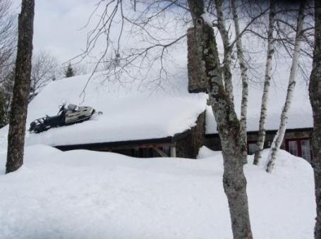
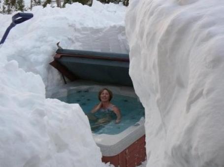
Every Snowmobiler's Fantasy? O.K. This is a file photo (this was NOT taken during this snowstorm), but I thought it was a funny shot, and a little attempted humor is essential right now, considering many Minnesotans are suffering from SNOW-RAGE!! This too shall pass...
Impassable Roads. According to an experimental product from the University of Wisconsin Highway 7 in far western Minnesota is impassable due to blowing and drifting and near-zero visibility. To see the latest conditions click here.
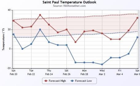
Cooling Trend. It won't be as cold as it was in January (or earlier this month), but the temperature trend is downward as we head into late February and the first week of March, temperatures running 10-15 degrees below average, with a potential for a string of subzero nights by the end of this week. Graphic courtesy of Ham Weather, a division of WeatherNation.
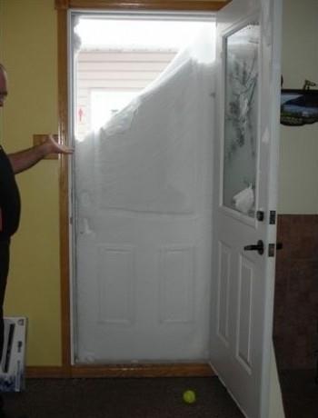
Have A Nice Day. There are reports of 3-5 foot drifts from this storm, rivaling what we all enjoyed/endured back in mid December. What a winter...
Friday Snow Potential. I don't expect a rerun of Sunday's storm - not even close, but a couple inches of additional snow may fall on Friday. Still too early for details/amounts/timing, but there's a chance.
Make It Stop. "When in a drought don't predict rain." We're (obviously) in a snowy pattern - and sometimes it just pays to go with the flow, what meteorologists call "persistence." A couple inches may fall Friday, but it will NOT be anything like what we just went through. The GFS model is hinting at a significant storm around March 7, but that's still 2 weeks off - a lot can happen between now and then. Hopefully it will detour south of Minnesota. We're due for a break right about now.
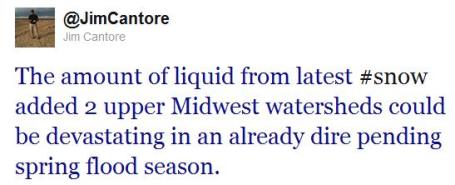
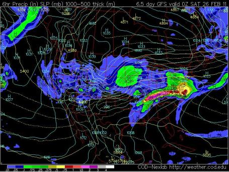
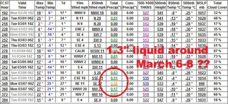
Flood Potential Just Ticked Up Again. A Sunday evening tweet from Jim Cantore at the Weather Channel. He's right. There is at least an inch of liquid water tied up in our most recent snowfall. It's unclear how this will impact river flooding in 30-40 days, but it can't help.
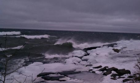
Wild Surf. Thanks to WeatherNation meteorologist Todd Nelson for snapping this photo up in the Duluth area, which is missing out on most of the snow - the forecast calls for only 1-3" for the Duluth area - the brunt of the snow is passing well south of Duluth/Superior.
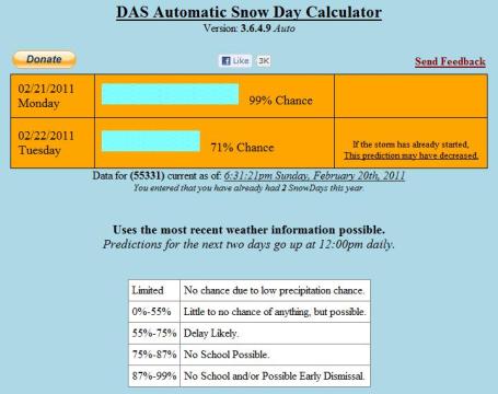
Snow Day Calculator. O.K. This is a bit hokey, but pretty effective. I put in the information for my hometown (Excelsior) and it came up with a 99% probability of a snow day on Monday. Too bad it's already President's Day and most kids have the day off. A wasted snow day. To check this out for yourself click here.
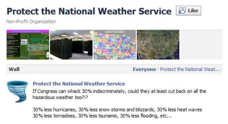
Protect The National Weather Service. Someone started up a Facebook page, and you might want to consider showing your support. America has the best weather service ont he planet, but it didn't happen by accident. There is a bill before Congress that would slash the National Weather Service budget by as much as 30%. That could have a direct impact on our ability to monitor current weather (maintain the network of Doppler radars, launch weather balloons, measure snowfall amounts - all these activities require meteorologists). I make a living interpreting (and adding value to) NWS data, but I realize the incredible importance of maintaining a world-class weather service. This is just one guy's opinion, I realize we have serious budget considerations and cuts have to come from somewhere, but a 30% cut could have a drastic impact on our ability to track and predict the weather. That's a pretty big deal.
* An Insider's Take On NWS Budget Cuts. Dan Koch represents the Little Rock office of the National Weather Service. He has more information on the current budget, the proposed cuts, and how this might impact operations (and the quality of the data and warnings many of us probably take for granted). "The National Weather Service budget is in the neighborhood of 800-850 million dollars per year, more or less. Early Saturday morning, the House of Representatives passed the budget resolution stripping 126 million dollars from the budget for the rest of FY 2011; now the resolution will be voted on by the Senate. To put things into perspective, 126 million dollars is a huge chunk of the NWS’s operating budget - approximately 28% of what is remaining for the fiscal year. Over 70 percent of the money received by the NWS goes for employee salaries; the remainder is divided between a number of expenses, including the cost of operating and maintaining equipment and facilities, maintenance and repair of instrumentation, acquisition of new systems, and research and development. I would argue that the NWS does not spend a lot of money on frivolous or trivial items. Our meteorologists staff 122 different field offices across the contiguous U.S., and in a handful of offices in Alaska, Hawaii, Guam, and Puerto Rico. Every weather office is staffed by highly trained meteorologists 24 hours a day, 7 days a week. The NWS also operates a number of national centers, such as the Storm Prediction Center and the National Hurricane Center, in addition to six regional headquarters, and a national headquarters just outside of our Nation's Capital. We also have a number of River Forecast Centers and Central Weather Service Units across the country, that specialize in hydrology and aviation weather."
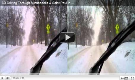
3-D Blizzard. Click here to see a YouTube video (which made me do a double-take). Now where did I stash those dorky 3-D glasses....

Snowy Sunday. The Twin Cities saw more snow than any other (official) reporting station on Sunday, nearly 7" as of 7 pm. There is 8" on the ground at MSP, a cool 20" up at International Falls. Daytime highs ranged from 16 at International Falls to 30 in Rochester.

(don't panic - this is a file photo. No idea where this is, but compared to this we just experienced "severe flurries". It's all about perspective, right?)
Paul's Conservation Minnesota Outlook for the Twin Cities and all of Minnesota:
TODAY: Winter Storm Warning. Snow slowly tapers to flurries by afternoon. Another inch or two. Totals from 12-18". Winds: NE 15. High: 21
MONDAY NIGHT: Partly cloudy and colder. Low: 3
TUESDAY: Sun returns, better travel. High: 24
WEDNESDAY: Clouds increase, light PM snow - little accumulation expected. High: 33
THURSDAY: Colder with some sun. High: 23
FRIDAY: More snow, few inches possible. Low: 5. High: 16
SATURDAY: Snow tapers to flurries, numbing breeze. Low: 0 High: 15
SUNDAY: Intervals of sun, plenty cold. Low: 5. High: 19
Surplus of Snow
We sure got our Winter Mojo back this year. The previous 6 winters averaged only 39" of snow - and we became a tad complacent. Now we're on our way to 80, maybe 90" of snow. Good grief. We picked up at least 13" in the cities, making this the second snowiest winter (to date) in modern-day records. We're up to at least 74" as of Feb. 20. Only 1982 was snowier, with 76.9" in the Twin Cities as of Feb. 20.
Why so much snow? The storm track has been just south of Minnesota much of the winter, a perfect recipe for excessive shoveling. The balance has to be just right: too much cold air and the storms will sail south; too much moisture and warmth and it changes over to ice and rain. That old saying, "when in a drought, don't predict rain" rings true. Meteorologists call it "persistent", which is a fancy way of saying: go with the flow. About 1-3" falls today, pulling our snow totals to well over a foot. A few lucky towns may see 15-18".
Travel improves Tuesday, the next chance of snow Friday. Temperatures cool off as the week goes on but no nasty Arctic outbreaks are imminent. March will get off to a cold start, no more thaws lurking on the horizon. Is the heaviest snow over? No comment.

Paul Douglas Foundation. I'm giving a series of speeches, multimedia presentations, on everything from the "art" of weather forecasting to tornado chasing, climate change in Minnesota (hype or reality?) and the misadventures of a serial entrepreneur. If your company has a need for a speaker check out the web site for the foundation - help us support a handful of Minnesota charities and non-profits.

Safekey. Full disclosure: I'm on the Board of Directors of a small, Minnesota tech company, Safekey Corporation. They have invented a remarkable device that prevents you (or a loved one) from operating a vehicle while impaired (alcohol, drugs, it even works for sleep deprivation). Your vehicle won't start unless you can key in a quick, 2.4 second, computer-generated code. If you're impaired this becomes difficult, and the vehicle is disabled for an hour while you sober up. If you're sober it's not an issue (at all). If you're a parent of a 15 or 16 year old about to drive for the first time, or if you just want an added layer of safey, a personal insurance policy on someone you care about - it's an invaluable tool. It takes 45 minutes to install, and you may even be able to lower your insurance premium if you have a Safekey system installed. Check out their web site for more information. I really believe in this company, and their lifesaving technology. There are already a handful of people walking around this country who are alive because they had a Safekey system installed. There's nothing like it on the market today - for a couple hundred dollars you can have additional peace of mind. Every parent dreads that late-night phone call. Nothing can totally eliminate risk, but Safekey is an important breakthrough, a simple device that can lower risk, and protect you (from yourself), or add another level of safety and security for someone you care about. I'm a believer - after you read up on Safekey I predict you will be too.
Double check the MSP snow total. According the NWS website, 11.8" of snow fell on Feb 20th for MSP, not 13".
ReplyDeleteThis comment has been removed by the author.
ReplyDelete"Amazing insights on Minnesota's historic snowfall! If you're looking for a simple way to gauge snow day probabilities, try this Snow Forecasting tracker for accurate and quick predictions."
ReplyDelete