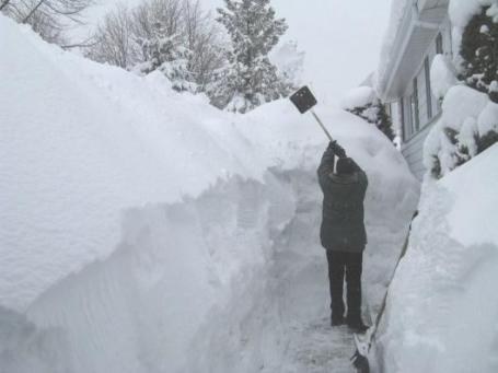
76.5" snowfall so far this winter in the metro area.
9" snow on the ground as of Wednesday evening.
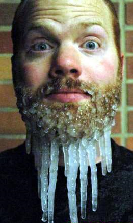
-3 F. low temperature Wednesday morning in the Twin Cities.
18 subzero nights so far this winter season in the Twin Cities (average for an entire winter is 28)
18 F. normal low for March 2.
17 F. reported high temperature in the cities on Wednesday.
34 F. normal high for March 2.
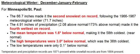
66.7" snow since December 1. It was the second snowiest "meteorological winter" since 1891. Only 1966-1967 was snowier in the Twin Cities.
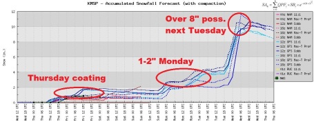
Insert Deep Sigh Here. O.K. Nothing is definite yet (it never is, come to think of it). But the latest GFS models (which go out 15 days) are fairly consistent printing out close to 1" of liquid water from Monday through Wednesday morning of next week. Although a thin layer of warmer air aloft may result in a brief changeover to freezing rain or sleet (ice pellets)
the majority of Tuesday's storm will probably fall as wet snow from the Twin Cities to Willmar and St. Cloud. Stay tuned for updates - a lot can (and will) happen between now and next week.
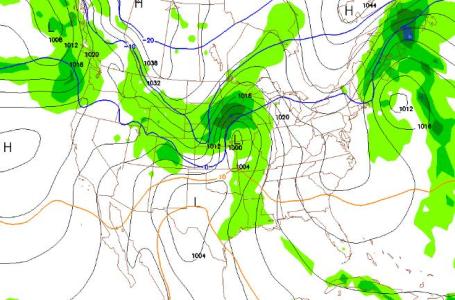
Primetime For Snow. The GFS forecast map (valid 7 pm Tuesday evening) shows the center of low pressure over far southwestern Minnesota, on a potentially favorable track for significant snow across much of central and southern Minnesota. The rain-snow line is forecast to push into far southern Minnesota; Rochester and Albert Lea may see more rain/ice than snow, keeping final snowfall tallies lower. Bottom line: it's still very early to be providing specifics about timing and amounts. Just know that we're still on track for what
may become one of the biggest storms of March.
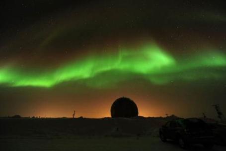
Dazzling Display Of Northern Lights Ignites Sky. A series of solar flares may be creating ideal conditions to see the Aurora Borealis, the Northern Lights, which has been lighting up the (far) northern sky in recent nights.
Details from Sky & Telescope and MSNBC: "
Solar wind from the sun is apparently creating spectacular auroras for skywatchers in northern latitudes around the world. And more dazzling northern lights displays are expected tonight. The aurora activity spiked early Tuesday when a solar wind stream slammed into Earth's magnetic field to create what scientists call a geomagnetic storm. NASA officials said that the event began with a relatively minor polar geomagnetic storm, but by late Monday it had intensified into a major cosmic tempest. "Spotters are now reporting auroras over Northern Ireland, Latvia, Norway and Sweden. If the trend continues, high-latitude sky watchers will likely witness bright auroras after nightfall on March 1-2," explained astronomer Tony Phillips in an announcement from NASA's Goddard Space Flight Center in Greenbelt, Md. " Northern-tier U.S. states such as Maine, Wisconsin, Minnesota and Washington could be favored with photographic and/or visual displays."
Gentle Reminder. Make sure your sunroof is closed later today; it'll only be a slushy inch or two, but you don't want to wind up on the "Fail" web site.
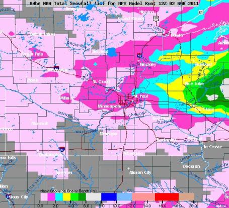
Nuisance Snow. Models are printing out a coating for the Twin Cities metro area, maybe an inch far eastern suburbs - 2" across parts of western Wisconsin. Snowfall totals will increase the farther east you drive on I-94. As much as 3-6" may fall closer to Eau Claire, Wisconsin.
Cringe-Worthy Statistics. Here are details about "meteorological winter", which runs from December 1 through February 28. The 66.7" that fell made it the second snowiest on record; 4.91" of liquid precipitation making it the 4th wettest. The (much heavier) levels of precipitation have forecasters increasingly concerned about the potential for severe, even extreme levels of river flooding roughly 1 month from now. Mean temperatures for the 3 month period were 1.6 F. colder than average. More details from the NWS
here.
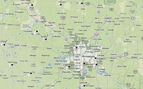
Wednesday Morning Lows. This map is hard to read - click
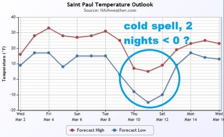
here for the full-screen version. More evidence of the "urban heat island": the offical low at MSP International Airport was -3 F, but Eden Prairie (Flying Cloud) saw -5 F, with -6 F reported at Lakeville and Buffalo, a chilly -8 F at Cambridge and St. Cloud and -9 F at Princeton. The last subzero reading of winter? Probably not, we'll probably dip below zero for 2 nights around March 10-12.
Signs Of Spring. Yes, we're still seeing cold fronts, but the length of the cold, and the intensity of the cold, are on the wave, the result of a sun angle as high in the sky as it was the second week of October. I could envision a couple of subzero nights between March 10-12, but the longer-range outlook is encouraging.
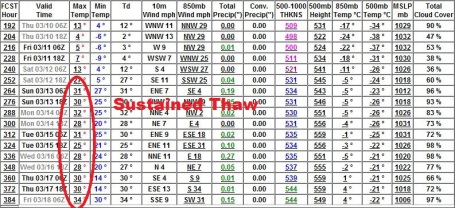
Real Hints of Spring? O.K. Only in Minnesota could the locals ever get excited and energized by 32 lousy degrees, but the models are finally hinting at an extended spell of 30s after March 12. The start of a sustainable thaw? Maybe. We're due for a recovery.
Primal Scream Time. I know, many Minnesotans are losing their stoic sense of (gallows) humor when it comes to our crazy weather extremes. Here's an e-mail I received from a friend yesterday who's had quiet enough of the "white stuff." Mike - I feel your pain.
"Dear Paul,
I just finished reading your most recent blog post in which you forecast 6"-12" of snow in our immediate future. Now, I am really happy that the new snow blower I got from the Home Depot in December has earned its keep thus far, but I do have one tiny favor to ask. When you see Mother Nature, can you please let her know we are ready to see the grass again? This snow storm thing is just getting out of hand and she needs to try something new. If she is disinclined to acquiesce to our request, please let me know and I will purchase a St. Bernard straight away so when I fall victim to a large drift in my backyard, some one will be able to find me."
Many thanks,
Mike
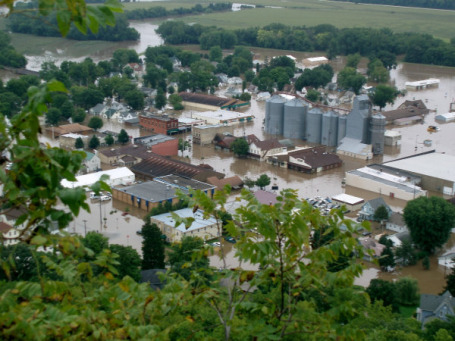
Little Time Remaining To Buy Flood Insurance. This is going to be a potential devasting spring for river flooding in Minnesota, Wisconsin and the Dakotas, the result of high soil moisture levels and total snowfall amounts almost twice the normal amount. Here's an important
reminder from the Chanhassen office of the National Weather Service:
If you are thinking about flood insurance, the time to act is now!
Policies require a 30 day waiting period before becoming effective. And flooding typically begins sometime in March or early April - for central and southern Minnesota and west central Wisconsin.
Being prepared for a flood can not only help keep your family safe, it can also help minimize potential flood damage and reduce the costs of recovery. Many people ignore the risks of flooding, assuming they aren’t in a flood zone. While some areas are more prone to flooding than others, the reality is, floods are America’s #1 natural disaster and can happen anytime, anywhere. In fact, 90% of all natural disasters in the United States involve flooding. Additionally, the risk level of a particular area can change over time. New development, changes in levee classification, and environmental changes can alter the impact of flood waters on an area.
Flood Insurance in the United States is provided through the National Flood Insurance Program (NFIP). Policies require a 30-day waiting period before becoming effective. However, snowmelt flooding, heavy rainfall downpours, and flash flooding can occur with little warning. Even where flooding occurs more regularly and slowly, thirty days may be too long. For information about the National Flood Insurance Program click
here.
Update From Greg Spoden At The MN State Climatology Office. Click
here to see the complete report and February recap. A few highlights:
- There are several factors pointing towards major spring flooding for many of Minnesota's rivers and streams. Projections for many Minnesota river communities indicate a greater than 60 percent probability of major flooding. The probability of major flooding exceeds 80 percent at some locations and record flooding is a possibility.
- February 2011 precipitation totals were above historical averages in the southern two-thirds of Minnesota, below average in the northern one-third of the state.
- A large and intense winter storm on February 20-21 blanketed much of the southern two-thirds of Minnesota with over ten inches of snow. In many locations, storm snowfall totals broke daily records for the month of February. Storm liquid precipitation totals of one to two inches were reported in many communities, two to three times the MONTHLY precipitation normal.
- Most Minnesota counties report more than 12 inches of snow cover as of this writing. Snow depths for large sections of western and northern Minnesota exceed 18 inches. For much of west central and southwest Minnesota, present snow depths rank historically above the 95th percentile (1-in-20 year occurrence) for early March.
- Monthly mean temperatures for February 2011 were below average across Minnesota, falling short of the historical mean by one to five degrees. A mid-February thaw was more than offset by cold temperatures early and late in the month. The maximum temperature at Hibbing on February 16 was 60 degrees, the warmest February temperature ever recorded in that community.
I-95 Reopens. Wildfire Smoke Remains A Concern. Smoke from raging wildfires closed the main north-south artery in Florida for several hours late Tuesday, again Wednesday morning, but winds are easing and fire officials are making progress. An
update from the Orlando Sentinel: "
The Florida Highway Patrol has reopened Interstate 95 from State Road 46 in Brevard County to State Road 442 in Volusia County. That section had been closed for a few hours because of smoke from the 16,000-acre Iron Horse Fire on the Volusia-Brevard county line. Smoke still lingers in the area and troopers are monitoring conditions."
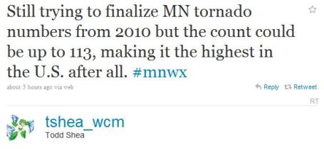
Tornado Recount. It's quite possible that 2010's Minnesota tornado count of 104 may be revised upward, after further research and review, to as many as 113. Remarkable. Thanks Todd.
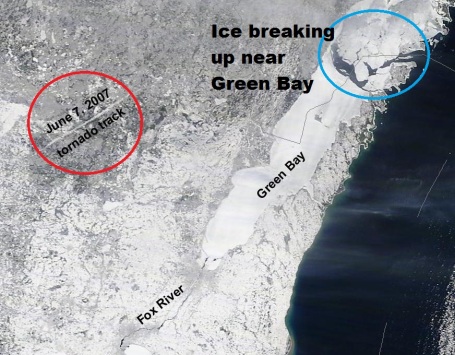
Unusual Sights From Space. Thanks to Jeff Last ("the severe guy") and Twitter for passing this on. A recent NASA "MODIS" Terra satellite image showed not only the ice breaking up on Green Bay, but snow accumulating in the track of the June 7, 2007 tornado that ripped across northern Wisconsin. The tornado downed thousands of trees, leaving behind grassland (that better reflect sunlight into space). I think this is the first time I've seen a tornado track, from space, during the winter months.
iPad 2. Time to geek out on the new Apple release. Worth upgrading? Not sure - probably won't know until I get one of these in my hands and see if it's really a big advance. Not sure I'd use the videoconferencing (much), but having the 2 cameras seems like a good idea. It's thinner, lighter, and comes in black or white. More
details from appleinsider.com "
The new iPad 2 is one-third thinner than the first-generation model, just 8.8mm thick, even thinner than the iPhone 4. At just 1.3 pounds, it is lighter than the previous 1.5 pound iPad. It will carry the same starting price of $499 for the entry-level 16GB Wi-Fi-only model. The device will begin shipping in just over a week, on Friday, March 11, in the U.S., while 26 more overseas countries will get the device on March 25. It also has rear and front facing cameras for recording video, taking photos, and FaceTime video chat. The new iPad also has a new A5 dual-core processor which offers up to 9 times faster graphics processing. Apple said the faster speeds of the new processor will not have any greater power consumption than the previous A4 processor."
Can Exercise Keep You Younger? I felt healthier just reading
this article from the New York Times. Yes, common sense we should all be exercising - but now there may be another powerful incentive to get up off the couch: "We all know that physical activity is beneficial in countless ways, but even so, Dr. Mark Tarnopolsky, a professor of pediatrics at McMaster University in Hamilton, Ontario, was startled to discover that exercise kept a strain of mice from becoming gray prematurely. But shiny fur was the least of its benefits. Indeed, in heartening new research published last week in The Proceedings of the National Academy of Sciences,
exercise reduced or eliminated almost every detrimental effect of aging in mice that had been genetically programmed to grow old at an accelerated pace. In the experiment, Dr. Tarnopolsky and his colleagues used lab rodents that carry a genetic mutation affecting how well their bodies repair malfunctioning mitochondria, which are tiny organelles within cells. Mitochondria combine oxygen and nutrients to create fuel for the cells — they are microscopic power generators."
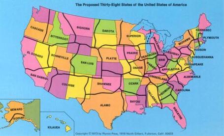
If America Had Only 38 States. Yes, it would have simplified things - or would it? I don't think the federal government ever came close to advocating this scheme, but it's humorous to think that (some) people were actually giving this serious consideration back in the 70s. A
story from mentalfloss.com: "
If George Etzel Pearcy had his way, Lynyrd Skynyrd’s famous song would have been called “Sweet Home Talladego.” In 1973, the California State University geography professor suggested that the U.S. should redraw its antiquated state boundaries and narrow the overall number of states to a mere thirty-eight. Pearcy’s proposed state lines were drawn in less-populated areas, isolating large cities and reducing their number within each state. He argued that if there were fewer cities vying for a state’s tax dollars, more money would be available for projects that would benefit all citizens. Because the current states were being chopped up beyond recognition, part of his plan included renaming the new states by referencing natural geologic features or the region’s cultural history. While he did have a rather staunch support network—economists, geographers, and even a few politicians argued that Pearcy’s plan might be crazy enough to work—the proposal was defeated in Washington, D.C. Imagine all the work that would have to be done to enact Pearcy’s plan: re-surveying the land, setting up new voter districts, new taxation infrastructure—basically starting the whole country over. It’s easy to see why the government balked."
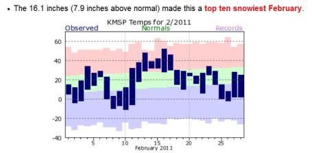
A Winter To Remember. At 16.1" February was one of the top 10 snowiest Februaries on record for the Twin Cities. Graph courtesy of the National Weather Service.
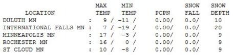
January Flashback. In spite of blue sky much of the day, and a sun as high in the sky as it was on October 7, we only managed a meager high of 17 in the Twin Cities. The mercury only hit 10 at St. Cloud and 6 at Alexandria. International Falls woke up to a brain-numging -19.
Paul's Conservation Minnesota Outlook for the Twin Cities and all of Minnesota:
TODAY: Coating of light snow and flurries, 1-2" possible over western WI. Wet roads. Winds: SE 10-15. High: near 30
THURSDAY NIGHT: Light snow tapers to flurries - slushy and slick roads. Low: 21
FRIDAY: Mostly cloudy and dry, better travel. High: 31
SATURDAY: Intervals of sun, still chilly. Low: 13. High: 28
SUNDAY: Clouds stream in, light PM snow? Low: 12. High: 29
MONDAY: Periods of light snow, 1-2" possible. Low: 20. High: 33
TUESDAY: Potential for significant snow. Possible mix changes to heavy snow, 6"+? Low: 23. High: 34
WEDNESDAY: Flurries taper, travel improves. Low; 22. High: 31
Weather Therapy
"When in a drought don't forecast rain," is an old nugget of wisdom that rings true. Bottom line: don't buck the trends. La Nina has sparked a renaissance for snow-lovers this winter, with a storm track from Des Moines to La Crosse and Wausau, perfect for heavy snow in the metro area. The Twin Cities have picked up 26" more snow than St. Cloud; some southern suburbs have seen 80-85" so far.
Normally stoic Minnesotans are losing their sense of humor. "Paul, I LOVE snow, but enough already!" read one recent message. Tweets, Facebook posts, smoking e-mails reeking of slushy frustration."Enough of this weather warrior crapola, Paul - make it stop!"
Weather modification? Not a chance. These storms are too vast for any human intervention or cloud seeding to have a prayer. Any company foolish enough to tinker with Mother Nature on a grand (synoptic) scale would be made up entirely of lawyers.
A coating of snow may fall today, no big deal on the highways. A much more formidable storm is brewing for early next week; 1-2" Sunday-Monday, but Tuesday looks like the main event as a big, sloppy storm tracks just to our south. Over 6" may fall, with a potential for 10-12" nearby.
"Character-building."
 Investigating Droughts And Maya Collapse
. What killed off the (highly advanced) Mayan civilization? An interesting
article from the New York Times: "
An important component of our research is the study of the past environment and climate changes. A team of Japanese geologists and plant scientists addresses this by analyzing lake sediments as part of the project financed by the Japanese Ministry of Education, Culture, Sports, Science and Technology and directed by Kazuo Aoyama. In contrast to archaeologists, who usually specialize in specific geographic regions, those researchers are global travelers. They have been taking lake cores from Japan, China, Cambodia, Bali, Easter Island, Egypt and Peru. The team is known for its uncanny ability to find annual varves and for its innovative analysis. Under specific conditions of seasonal change, lake hydrology and the anoxic water that prevents bottom-dwelling critters from disturbing sediments, thin laminations of deposits may form yearly in lake bottoms. These annual varves are time capsules of environmental data. Through the analysis of geochemistry, isotopes, pollens, diatoms (a group of algae) and other remains in each layer, scholars can trace changes in precipitation, vegetation, agricultural practice, erosion rates, volcanic eruptions, etc., in a yearly resolution."
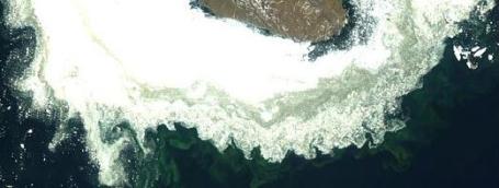 Global Warming Affecting Food Chain In Arctic Ocean
. It's been a strange winter in the Arctic - temperatures running 10-20 degrees above average in some (far) northern latitudes. Here's an
article from signonsandiego.com: "
The huge life-giving phytoplankton bloom that forms in the Arctic Ocean each summer is occurring progressively earlier, a change that might hurt the marine food chain, says new research from the Scripps Institution of Oceanography. Researchers attribute the shift to global climate change, which they say causes Arctic ice to thin and melt, creating gaps where the bloom can briefly flourish. The shift is most notable in Hudson Bay, Foxe Basin, Baffin Sea, off the coasts of Greenland, in the Kara Sea and around Novaya Zemlya, Scripps says. “It’s not clear if fish will adapt to the change, and whether it will disrupt critical life-cycle stages such as egg hatching and larvae development,” said Mati Kahru, the SIO oceanographer who led the study. “The bloom provides a major source of food for zooplankton, fish and bottom-dwelling animals. The advancement of the bloom time may have consequences for the Arctic ecosystem.”
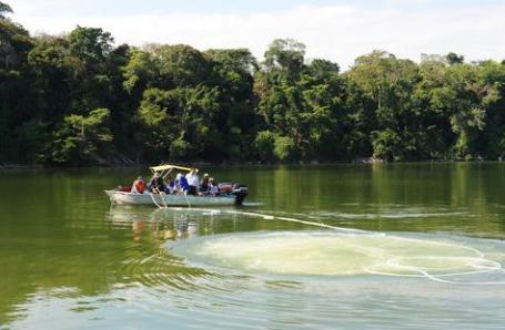
 Water Woes: Demand To Outstrip Supply By 40% In 20 Years
. A
story from the Times of India: "
LONDON: The demand for water in the world may exceed its supply by 40% within the next 20 years due to global warming and population growth, scientists have warned. As looming water shortages threaten agriculture, industry and the communities, a new way of thinking about water is highly essential, suggested the experts who gathered at an international meeting in Canada. They warned that in the next two decades, a third of world population would get only half the water they require to meet basic needs, the Daily Mail reported. Around 300 scientists, policy makers, and economists attended the international meeting in Ottawa hosted by the Canadian Water Network (CWN) in the run-up to the World Water Day."


No comments:
Post a Comment