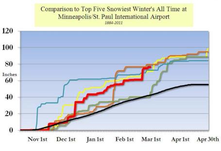
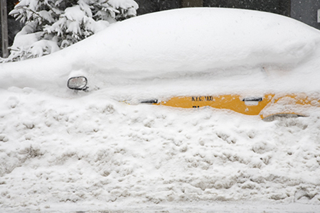
76.6" snowfall so far in the Twin Cities.
1/10" snow so far in March.
8" snow on the ground as of Saturday evening.
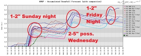
2" additional snow possible by Monday morning.
2-4" additional on Wednesday (heaviest amounts southeastern suburbs of St. Paul).
1-2" expected Friday night.
6"+ possible March 16-17.
6"+ possible March 19-20
100% probability we'll never take a Minnesota spring for granted ever again.
 Sunday Afternoon GFS Run
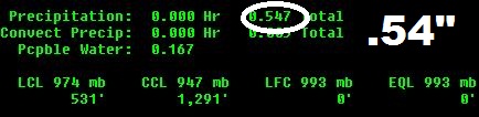
. The 18z run printed out .49" of liquid precipitation by Thursday morning, a total of roughly 4-5" between tonight and Thursday.
 Trending Upward
. Last night's (00z) GFS run increased the amounts by rougly .05" - no big deal, right? But this may be the start of a trend, a gradual northward shift in the storm track that could (in theory) bring heavier snow bands into the Twin Cities, especially the southern and eastern suburbs. We'll see if this trend continues today. The GFS has a bad habit of predicting that storms will stay farther south (than the actually do).
This "southward bias" is something we try to compensate for. Bottom line: we may wind up getting more than just a couple inches on Wednesday.
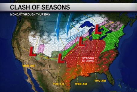
March: Something For Everyone. We caught a break last week (only a tenth of an inch in the last week!) We'll make up for lost time this week. A ripple of low pressure squeezes out an inch or two of snow tonight and early Monday, but the Main Event is still on-track for Tuesday night and Wednesday. Speaking of tracks, the models are still all over the map, but there seems to be more of a northward shift in the projected path of Wednesday's storm, which would push the heaviest snow bands into southeastern Minnesota, very close to MSP. I doubt St. Cloud or Brainerd will see heavy snow from this system - but the immediate metro area is still expecting a "plowable" snowfall Wednesday. It looks like the southeastern suburbs of St. Paul could pick up nearly twice as much snow as Maple Grove, Plymouth and Elk River. Once again we're on the edge...and yes, meteorologists are on edge as well. What can possibly go wrong? Thanks to WeatherNation graphic artist and developer Nick Shipes for whipping up this explainer-graphic.
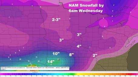
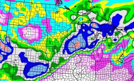
. This is NAM data (which goes out 84 hours). The metro area may pick up an inch or so Sunday night and early Monday, followed by a brief lull. The main storm lifts northward Tuesday night into Wednesday, with the heaviest amounts (8-10") predicted for far southwestern Minnesota by breakfast on Wednesday. Thanks to Andy Revering and his creation:
F5data.com, for helping me fine-tune these snowfall maps for the Upper Midwest.
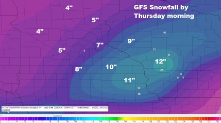
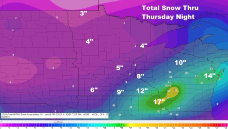
Snowfall Totals. Keep in mind this forecast is a total snowfall map, factoring in the inch or two we pick up late Sunday into early Monday, added to the main surge of moisture, which surges just south/east of the Twin Cities on Wednesday. Keep in the mind that the GFS has a "southward bias", the model seems to consistently push storms farther south than they wind up tracking - so that has us a bit nervous. All it would take for MSP to pick up closer to 5-10" would be a slight northward jog in the storm track (by only 75 miles or so). We aren't exactly out of the woods with our midweek "snow event."
A Little Close For Comfort. The Twin Cities will probably wind up on the northern/western edge of the really significant snow. There's a much better chance of 10" or more on Wednesday closer to Rochester and Winona, maybe well over a foot for southwestern Wisconsin and northeastern Iowa.
A Very Close Call. Some storms are cut and dry. This one is not. You can see how close we are to the (very) significant snow accumulations, most of it coming on Wednesday as a storm tracks from the Texas Panhandle across Missouri, on a course toward the Quad Cities (or Rockford). If the storm jogs a little farther east (like the models were predicting on Sunday) the heaviest snow bands will come no closer than La Crosse, possibly Rochester. But if the storm hooks farther north/west, on a track closer to Waterloo and Wausau, then MSP could find itself in the heavy snow-zone. I have a bad feeling about this storm....it wouldn't take much for the Twin Cities to get clobbered on Wednesday. Not sure I entirely trust the current model run. Let's check out a few more runs and see if the (northward trend in the storm track) continues.
Mixed-Up Mess. Why settle for a single storm when you can have three "snow events"? The first burst of snow comes tonight (1-2" possible, maybe more over central Minnesota). This first ripple of low pressure is out ahead of the main storm, which is still forecast to pass off just south/east of MSP Wednesday, capable of a plowable 2-5" (heaviest amounts southeast suburbs of St. Paul). Another inch or two may fall Friday night. Many towns and suburbs within 50 miles of the Twin Cities may have a fresh 4-7" of snow (total), from all 3 systems, by Saturday...considerably more across southeastern Minnesota, closer to the storm track.
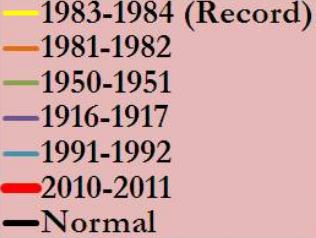
On A Record Trajectory For Snow. If we get "average" snowfall through April (about 13") the Twin Cities would finish in the Top 3 winters on record, with 90" of snow. The GFS is hinting at considerably more than 13" over the next 15 days. I'm hoping the GFS is wrong. Our current winter is the red line - the all-time record for winter snow is 98.6" in 1983-84, and I have a hunch we'll come very, very close.
Graphics courtesy of the National Weather Service.
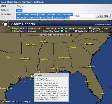
Severe Saturday. At least half a dozen tornadoes skipped across Louisiana on Saturday, injuring dozens, leading to several possible fatalities. A State of Emergency has been declared - the full extent of the damage may not be known until later today, when helicopters can survey the storm-ravaged towns.
Graphic courtesy of Ham Weather, a division of WeatherNation.
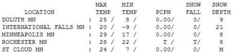
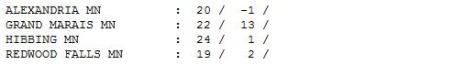
Sunny Saturday. Yes, the blue sky helped - it's a lot brighter out there, you can really feel that higher sun angle. Gurgling drainspouts and melting icicles, in spite of the fact that the high was only 29 in the Twin Cities, 6 degrees cooler than average. It never got above 24 in St. Cloud, 19 at Redwood Falls (more snow on the ground across southwestern Minnesota).
Paul's Conservation Minnesota Outook for the Twin Cities and all of Minnesota:
TODAY: Dry start, clouds increase/thicken. Light snow arrives this afternoon. WInds: SE 10. High: 28
SUNDAY NIGHT: Light snow and flurries, 1-2" possible. Low: 22
MONDAY: Light snow tapers to flurries. Most freeways should be wet/slushy. High: 31
TUESDAY: Wet snow redevelops, picking up in intensity Tuesday night. High: 33
WEDNESDAY: Snow likely. Heaviest snow stays south. Potential for 3-5" metro, with 8-10" over southeastern MN and southwestern Wisconsin. High: 33
THURSDAY: Flurries taper, skies clear, better travel. Low: 25. High: 34
FRIDAY: Fading sun, nighttime snow expected, maybe 1-2". Low: 22. High: 35
SATURDAY: Windy, snow tapers to flurries. Low: 20. High: near 30 (falling during the day).
Making Sausage
Sausage tastes great, but you probably don't want to see it being made. So it goes with long-range weather forecasts. Minnesota is a state of armchair meteorologists. Think Fantasy Football, with weather charts. EVERYONE has an opinion. "The GFS pushes the storm south! I detect a wobble on the ECMWF! The Cobb Method says only 4 inches!" Second-guessing, trash-talking, and that's just family members!
With raw data & weather models on the web anyone can now forecast storms. On my blog I'm trying to highlight the challenges: the dueling models and maddening flip-flops that can lead to temporary insanity.
Every storm is different, the forecast rarely black or white - but rather some nebulous shade of gray. The forecast changes as new data arrives. A maddening process? Yep.
Light snow starts up this afternoon, 2" by Monday, 3" by Tuesday. And then the Main Event arrives Wednesday. It still appears the heaviest snow bands will set up over far southeastern MN, maybe a foot for southwest Wisconsin. We may pick up a "plowable" snowfall, maybe an additional 2-5" Wednesday. Yet another sloppy storm (over 1" liquid, mostly-snow) arrives around March 17.
Feel free to disagree.
Altered State. A
story from the Toronto Sun: "
The climate change cat is out of the bag. Most scientists agree that even if we could stop producing greenhouse gas (GHG) emissions immediately, what's already in the atmosphere will impact global weather systems until the end of this century, and beyond. It's probable that the impacts already being felt in Canada and around the world will only get worse. These include flooding, heat waves, hurricanes, epidemics, ice storms and droughts. Now, governments are beginning to focus on building resilient communities capable of adapting to climate events. The science of adaptation is still in its infancy and most experts agree that it is a moving target. There is no steady state of being adapted, according to The London climate change adaptation strategy (UK). "Measures that manage the impacts of our climate today may not provide the same level of protection or opportunity in the future, and so new measures will be needed as different thresholds are reached," according to the UK Strategy."
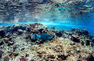
Testing The Waters. Coral reefs worldwide are feeling the effects of acidification, the result of excess carbon. Here's a
story from Time Magazine that highlights the long-term risks: "
Shark humor has its time and place, but not when I'm snorkeling somewhere called Shark Bay. At the Heron Island Research Station, a laboratory on the teardrop-shaped atoll 45 miles (72 km) off Australia's east coast, the suntanned, chirpy station manager gives a parting wave to the three students who are taking me out for my first look at the legendary corals of the Great Barrier Reef. "Just don't get eaten, will you?" she says. Ha-ha. Happily, there are no sharks in Shark Bay that morning; in fact, there's not a whole lot of anything. As I follow the students' snorkels, we pass over circular beds of brown, monochromatic coral and empty expanses of rippled sand. A handful of small, glimmering fish hover in the water column, but they're the only life we see during an hour-long swim. Where are the schools of coral trout? The famed Maori wrasse? Wading back to shore, one of the students shrugs: "Sorry there wasn't more." The Great Barrier Reef is one of the world's natural wonders, covering an area larger than Italy and drawing nearly 2 million tourists every year to boat, swim, snorkel and dive amid its elaborate flora and fauna. It generates some $6 billion in revenue for Australia annually and provides employment to more than 50,000 people. It's also one of the planet's most fragile ecosystems, home to more than 11,000 species that live, if not necessarily in harmony, in a carefully orchestrated symbiotic balance. At the foundation of this giant ecological and commercial enterprise is one tiny marine organism: the coral."
No comments:
Post a Comment