76.6" snowfall so far this winter.
.1" snowfall so far in March.
9" snow on the ground in the Twin Cities as of Friday evening.
30 F. high temperature Friday in the Twin Cities.
35 F. average high at MSP for March 4.
61 F. Record high for March 4, set most recently in 2000.
Breaking (Weather) News: we may just catch a break. It's not definite yet (it never is), but the latest computer runs keep the heaviest snow well south of home next week. We may still wind up with a "plowable" accumulation by Wednesday, but the potential for a major snowfall (defined as a foot or more)
as diminished. That said, I'm still a bit nervous, with a major storm (laden with moisture from the Gulf of Mexico) spinning up just to our south. If future models nudge the track 100-200 miles farther north we would be right back in the heavy snow zone. But for now the risk of major travel hassles has dropped a few big notches.
Southward Shift. The 18z run of the GFS takes the storm 100-150 miles farther south, moisture wrapping around the center of low pressure (near Kansas City at 7 am Wednesday). The heaviest snow is forecast to set up across Iowa and southern Wisconsin. The reality: there are often "wobbles" in the storm track this far out. The trend is for the storm to take a more southerly detour, just brushing MSP with a few inches - possibly something in the 2-5" range Wednesday. The risk has dropped, but we'll have to watch future runs to make sure the track doesn't shift to the north again. I've seen that happen more times than I care to relate.
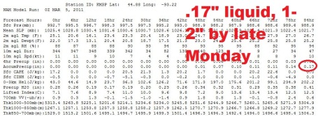 Slushy Monday
. A quiet weekend (temperatures about 5 degrees below average) gives way to light snow Sunday night and Monday, the first wave of low pressure rippling across the Upper Midwest. .17" liquid could translate into an inch or two of slushy snow by Monday evening.
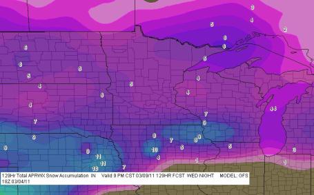 Predicted Snow Totals Through Next Thursday
. The latest GFS models cut back (dramatically) on snow amounts. The heaviest amounts (6-10") are forecast to fall from Nebraska into northern Iowa and southwestern Wisconsin, with some 4-7" amounts over far southern MN, closer to 3-5" in the metro (most of it coming next Wednesday). You can call these maps up for yourself on your PC or Mac with a modest monthly subscription (no, I don't get a cut) - check out
F5data.com for more details. It's a very powerful program.
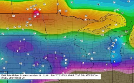
Total Snow Predicted Through March 20. The 384 forecast (never wrong!) is predicting closer to 12" of snow for the Twin Cities metro between now and 6 am March 20. The heaviest amounts over the next 15 days are now forecast to fall over the northern third of Minnesota and much of North Dakota. It's quite a U-Turn, a dramatic change from yesterday's 53" target over southwestern Minnesota, another reason why any long-range forecast should be taken with a huge, skeptical grain of salt.
This far out the models are erratic, at times useless. And yet it's like a Charlie Sheen rant. It's a train-wreck, but you just can't look away. March may devolve into an atmospheric train-wreck between heavy wet snow, potholes, mud and the almost inevitable flooding expected by the end of the month into April. Odds favor more snow than average (10"), and often we want to know...the unknowable. A foot of snow over the next 15 days? Any other winter season I'd laugh it off. Not this winter.
*
I think the (current) GFS solution is closer to reality. Not sure about the storm predicted for March 14-16 (see below), but my gut is telling me total amounts of wet snow will be closer to 12" over the next 15 days - still enough wet, slushy snow to aggravate our mounting flood threat.
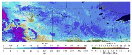
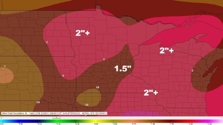
Liquid Precipitation Outlook. This is the GFS total precipitation (liquid) forecast through March 20; around 1.5" of water predicted for much of Minnesota, as much as 2" over the northwestern half of MN and much of Wisconsin. We'll see if the GFS is on the right track - but if this forecast verifies the impact on Minnesota's flood season would be significant, making an already bad situation an order of magnitude worse. (source: GFS and F5data.com).
Near Miss? The latest GFS model run still spreads accumulating snow into the Twin Cities Wednesday, but a more southerly storm track keeps the heaviest snow bands over far southern Minnesota and southern Wisconsin, where some 10-12"+ amounts are still possible. We'll see if this is a true trend, or a fluke. I've seen it before - the models go back and forth, hinting at a southerly track, only to get hammered with heavy, wet snow. It's the first sign I've seen (in the last 3 days) that MSP might, just might be spared the heaviest snowfall amounts.
Southward Shift? The storm is still 4 days away, a lot can (and will) happen between now and then. But most of the models seem to be nudging the storm track 75-150 miles farther south and east, on a track that could dump very heavy snow (ice and rain) on Iowa, far southeastern Minnesota and parts of central and southern Wisconsin Wednesday. It's too early to write off this storm - even with a southerly track we could still pick up a significant snowfall, perhaps something in the 4-8" range. Nobody wants to hear this, but it's the truth: it's still too early to know with any high level of certainty. All we can do is look at all the model solutions, look for trends, and hang on for dear life.
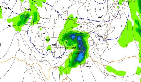
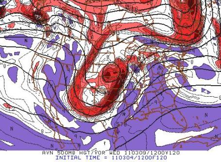
A Surge From the Gulf. Here are the predicted winds at 500 mb (about 18,000 feet above the ground) next Wednesday morning, a wind flow direct from Texas, allowing moisture from the Gulf of Mexico to flow north. A difference of 75 miles in where the storm tracks could make the difference between 4" and 14". Predicting that kind of nuance 4 days in advance is wishful thinking. If it were possible I'd be sipping cold beer on some tropical island. It's not, and probably never will be, not in our lifetime. All we can do is look at (all) the models, look for trends, see where the models are agreeing and coverging and (ultimately) put our money on the model that seems to have the best handle on the pattern. The only thing I can liken it to is
Fantasy Football. You make your picks (based on the best information available), and then you adjust your roster, make a few trades, try to improve your hand (like poker) and do the best you can with the (imperfect/changing) information at hand. In the end I've found (the hard way) that it pays to be conservative. If the models are spitting out 15", better to be conservative and actually predict half that number. That usually winds up being closer to reality. Why do nearly (all) meteorologists tend to overpredict snow? Our biggest unspoken fear: predicting "flurries", only to to wake up the next morning to a foot of flurries. Readers and viewers have long memories. They NEVER forget a bust like that. People are still pissed when you predict 10" and only 4" falls, but not nearly as furious as an "unpredicted storm" that catches them off-guard. That is the worst sin, right up there with missing a tornado or not warning people of rain on July 4. End of sermon. Sorry, got a little carried away.
Storm Synopsis From The Chanhassen Office Of The National Weather Service:
NEXT WEEK...FOR MONDAY INTO THE DAY TUESDAY THE CONFIDENCE IN THE
FORECAST REMAINS LOW WITH VARYING DEPICTIONS BETWEEN GUIDANCE AS
THE PATTERN TRANSITIONS. WHILE HAVE MAINTAINED A CHANCE OF
SNOW...IT IS POSSIBLE THIS PERIOD HAS VERY LITTLE IN ACCUMULATION.
THE EMPHASIS REMAINS ON LATER TUESDAY THROUGH WEDNESDAY AS A
COLORADO LOW SYSTEM EVOLVES AND TRANSITIONS NORTHEAST. THE
GFS...EC...AND CANADIAN GEM MODELS HAVE ALL TRENDED SOUTH WITH
THE EVOLUTION OF THIS...ESPECIALLY THE GEM. THE ENSEMBLES HAVE AS
WELL...THOUGH THE SPREAD HAS ACTUALLY INCREASED. THIS LEADS TO
THE HEAVIEST QPF FROM THE CENTRAL PLAINS INTO IA AND SOUTHERN
MN...AS OPPOSED TO CENTRAL MN. THE QPF IS STILL APPRECIABLE IN
SOUTHERN MN...WITH GFS COBB RATIOS SHOWING SIX TO TEN INCHES.
WOBBLES ARE INEVITABLE IN THE MODELS THIS MANY DAYS OUT...SO IN
GENERAL HAVE NOT SHIFTED MUCH IN THE FORECAST. A BIT CONCERNED BY
LATE TUESDAY NIGHT INTO THE DAY WEDNESDAY THE AMOUNT OF CONVECTION
THAT MAY BE OFF TO OUR SOUTHEAST HINDERING IDEAL MOISTURE
TRANSPORT INTO THE SYSTEM...ESPECIALLY WHEN IT OCCLUDES. STILL
MAGNITUDES ARE WELL ABOVE NORMAL. THE IMPACT IN THE FORECAST AREA
APPEARS TO BE MORE LATER TUESDAY NIGHT AND WEDNESDAY...SO HAVE
HIGH POPS OVER MUCH OF THE AREA DURING THAT TIME. HAVE NOT
INCLUDED ANY MENTION OF RAIN AS THE CHANCES APPEAR TO BE LESS THAN
20 PERCENT GIVEN THE ENVELOPE OF SOLUTIONS RIGHT NOW...AND JUST AN
INHERENT COOL ATMOSPHERE THIS SYSTEM WILL BE MOVING INTO. LOOKS
LIKE A SMALL DIURNAL TEMPERATURE RANGE WITH PLENTY OF CLOUDS IN
THAT TIME.
. According to NOAA there is 20-30" on the ground over much of southwestern Minnesota, South Dakota and the MN Arrowhead. As much as 3-6" of liquid water is trapped in that snow cover,
by some estimates as much as 6-8" over southwestern Minnesota. Source:
NOAA.
Daily Twin Cities Snowfall Records In March:
Rank Value Ending Date
1 14.7" 3/31/1985
2 13.7" 3/22/1952
3 12.6" 3/3/1985
4 12.5" 3/8/1999
5 11.6" 3/23/1966
Monthly Twin Cities Snowfall Records For March:
Rank Value Ending Date
1 40.0" 1951
2 37.1" 1965
3 36.8" 1985
4 29.9" 1917
5 25.6" 1940
Growing Flood Potential. Bob Weisman, Professor of Earth and Atmospheric Sciences at St. Cloud State University has a terrific
overview of the snow and flood situation facing Minnesota in his blog. Here are a few highlights: "
Snow depth is still over 20 inches in southwestern and west central Minnesota, plus parts of the Twin Cities. That puts a lot of the new snow in the Minnesota and Mississippi River basins with some in the Red River basin. Thanks to that late February storm, the area with at least 10 inches covers more of east central Minnesota than before that storm. There's between 6 and 10 inches of water locked up in the snow pack in southwestern Minnesota locked up in that snow pack in western Minnesota and the eastern Dakotas. We still have 2-4 inches of water locked up in the snowpack in east central Minnesota. Time is rapidly running out to purchase federal flood insurance. It must be purchased at least 30 days before any flooding and the snow melt is likely to occur sometime between mid-March and early April.
St. Cloud Winter Snowy, Wet, and Not That Cold
I finished the 2010-2011 St. Cloud winter weather summary. In St. Cloud, the winter had frequent, but small snow events, which added up to the 4th highest snowfall and the 4th highest amount of liquid among St. Cloud meteorological winters (Dec. 1- Feb. 28), but a temperature only about a degree and a half colder than average. The one odd fact is that it was only the sixth winter with at least 10 inches of snow in each winter month. All five of those previous winters had yet another month with at least 10 inches of snow, which doesn't bode well for March."
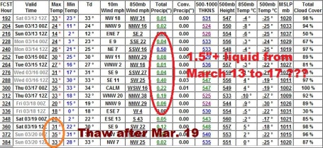
Hints Of A Second Storm. But wait, there's more! Ugh. The (dreaded) GFS model is bringing another potentially big, sloppy, southern storm northward around March 14-17, printing out over 1.5" liquid. Temperatures aloft may be close to freezing, meaning a rain/snow mix with this next storm. Any extended thaw will be delayed until after March 19 or so.
High Water Risk Rises Even Higher. I really don't want to sound melodramatic or be accused of "hyping the weather" , but this really is a potentially dire scenario for river flooding come April. The flood situation would be bad enough with just the snow we have on the ground melting over the next 2-4 weeks. But if we do, in fact, see another 1-3 feet of snow between now and the end of March the flood risk will go from severe to extreme. Many factors are in play: record rains last autumn left the ground saturated, waterlogged. There's 3-6" of liquid water already trapped in the snow that's on the ground. Another 1-3" of liquid precipitation, on top of what we already have, would push many Minnesota rivers to record levels. I think we'll be close to levels not seen since 1965. If you live in (or near) the flood plain it's time to check your flood insurance policies and come up with an action plan for your family. My hunch is that rivers won't crest until mid April, so there's still time, but it's important that you take action (especially with insurance policies) NOW. Don't wait until the rivers start to rise. From a Star Tribune
article written by Bill McAuliffe:
Every passing snowstorm is raising the already-serious risks of springtime floods across Minnesota. Chances of river levels reaching into the top five on record nearly doubled from 40 percent to more than 80 percent at Stillwater, where the Stillwater Bridge is almost certain to be closed. Chances also jumped to better than 80 percent at St. Paul and Jordan in updates released Thursday. That was thanks to up to 20 inches of snow from a Presidents' Day storm, the forecast for more next week, and the turn of the calendar toward thaw and thunderstorm season. "We're now starting to get into a warmer time of the year, where the snow could melt quicker, and we have more rains," said Dan Luna, meteorologist in charge of the National Weather Service Twin Cities office. That means the risks of historic or record flooding, "can't go much higher," Luna said."
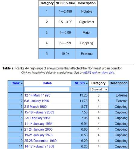
Forecast: Increasingly Snowy. Here's an interesting
article from NOAA, showing that
7 of the top 44 snowstorms since 1950 have hit the northeastern USA in the last 2 years. It also talks about the "Northeast Snowfall Impact Scale". Much like tornadoes and hurricanes, snowstorms are ranked on a scale from 1 to 5, based on not only on how much snow fell, but population, impact on transportation, and other factors: "
While the Fujita and Saffir-Simpson Scales characterize tornadoes and hurricanes respectively, there is no widely used scale to classify snowstorms. The Northeast Snowfall Impact Scale (NESIS) developed by Paul Kocin and Louis Uccellini of the National Weather Service (Kocin and Uccellini, 2004) characterizes and ranks high-impact Northeast snowstorms. These storms have large areas of 10 inch snowfall accumulations and greater. NESIS has five categories: Extreme, Crippling, Major, Significant, and Notable. The index differs from other meteorological indices in that it uses population information in addition to meteorological measurements. Thus NESIS gives an indication of a storm's societal impacts. This scale was developed because of the impact Northeast snowstorms can have on the rest of the country in terms of transportation and economic impact."
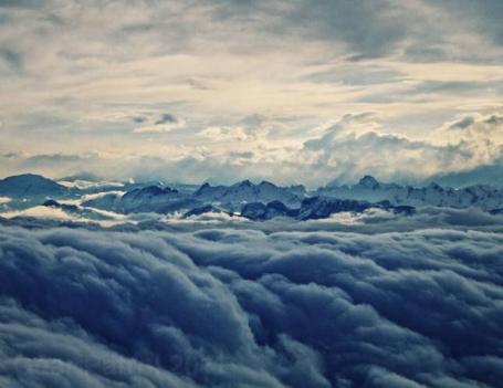
Viewfinder: Rolling Clouds at 10,000 Feet Above The Swiss Alps. Yes, you have to do a bit of work to get a photograph like this. From
gearpatrol.com: "
Every now and then, when you’re asked to put away the electronics on a flight it’s worth bending the rules to keep one, the camera, out for an extra few minutes. Especially during those last 10-15,000 feet of final approach where the vistas can potentially be striking. Case in point: this dramatic cloudscape we captured of clouds rolling over the Swiss Alps on our descent into Geneva Airport for the 2011 Geneva Auto Show. Captured on a Canon 7D with Tamron 18-270mm lens @ f6.0 & UV filter."
Lenovo's Laptops First To Offer "Eye-Control" Ability. If you're too lazy to use a track-pad or a mouse, now you can just blink your eyes to scroll the page, call up another window - order a Big Mac online. I certainly see the application for people who are paralyzed, but the jury is still out on whether this is functionality the rest of us really need. Here's the
latest from Fast Company: "
Lenovo and Tobii today unveiled what they're calling the "world's first eye-controlled laptop," and they're giving it a public demo at the CeBIT show in Germany. The idea is to add what the makers call a "truly natural interface" into everyday computing situations, allowing users of the laptop to control what happens in the UI using keyboard, mouse and where they glance on the screen--not entirely unlike the hand-eye-coordinated actions we do in non-computing environments. This taps into the current trend of natural user interfaces, and could change how you think about PCs."
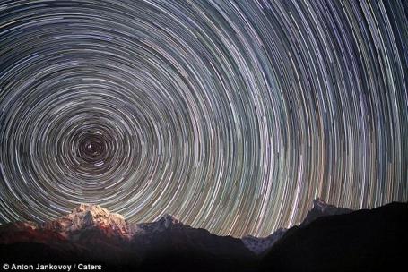
Kaleidoscope In The Sky: The Swirling Star Trail Taking Center Stage High Above Mt. Everest. A dazzling series of photographs
highlighted in the U.K. Daily Mail:
"It looks like an Artex paint finish so beloved by suburban households in the 1970s. But this amazing images is actually a swirling star trail above Mount Everest in the Himalayas. Photographer Anton Jankovoy spent months camping at the foot of the world's highest peak patiently waiting for the right weather conditions. The 23-year-old was so determined not to leave until he had accomplished his mission that he even began meditating to overcome the freezing temperatures. After three years dedicated to the project, Mr Jankovoy finally caught a series of stunning star trails."
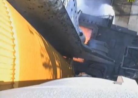
This Is What 44 MILLION Horsepower Looks Like. I've never seen a true HD video of launch from the vantagepoint of the Space Shuttle. Gizmodo has the story, and some
spectacular video here: "
NASA has released this beautiful, crystal-clear video of Discovery's launch. It was taken from an HD camera mounted on the left solid rocket booster, during liftoff of the shuttle for mission STS-133. Take a close look. There have been other booster videos before, but not only this one is especially impressive, it's also the last time you are going to see Discovery rising up to the stars. The space shuttle uses two solid fuel boosters, giant fireworks that produce 2,800,000 pounds of force each. At liftoff, each produces 12,500,000 newtons and continue to burn for 124 seconds. The spacecraft's own engines produce a combined 12,000 pounds of force (54.4 kN), and accelerate and decelerate as the shuttle goes through different launch phases, to reduce shock."
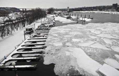
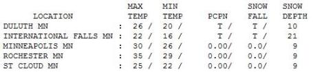
Gray Friday. Skies tried to brighten a little late in the day, but in the end dry air just couldn't break through a weak inversion that trapped low stratus clouds and kept us overcast. Highs ranged from 20 at Alexandria to 25 in St. Cloud to 30 in the Twin Cities, where 9" of heavy, wet, cement-like snow is on the ground.
(photo courtesy of the New York Times)
Paul's Conservation Minnesota Outlook for the Twin Cities and all of Minnesota:
TODAY: Peeks of sun, good travel. Winds: NW 10-15. High: 27
SATURDAY NIGHT: Partly to mostly cloudy - still dry. Low: 12
SUNDAY: Dry start, clouds increase with light snow late PM hours, maybe a coating of snow Sunday night. High: 25
MONDAY: Wet slushy snow, 1-2" possible. High: 31
TUESDAY: Snow tapers to flurries - little accumulation during the day. Heavier snow may arrive Tuesday night. High: 33
WEDNESDAY: Potentially heavier snow as the main storm tracks south of MN, 2-5" possible as the bulk of the snow passes south of the Twin Cities. High: 33
THURSDAY: Flurries taper, better travel. Low: 18. High: 26
FRIDAY: Mostly cloudy, no thaw yet. Low: 15. High: 29
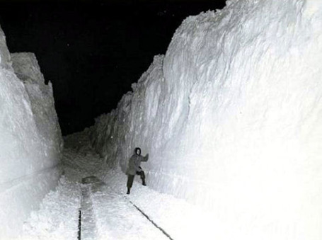
Blizzard of 1949. File photo from Nebraska.
Dueling Models
"All this technology, can't you guys DO anything about the weather yet?" The short answer is no. Back in the 70s we had one weather model, the "LFM". Now there are dozens of models, each one using different physics and "initialization" schemes for inputting current data. The problem: there's no way to get an accurate global snapshot. Data is sparse over oceans and third-world countries. Junk in, junk out. That's why the 7-Day forecast isn't better, and why the forecast changes so dramatically (as new, fresher data arrives).
With Doppler and supercomputers there is an expectation that we can now nail a storm, even one that's a week away. The reality: we can detect trends, but offering up details more than 36 hours away is futile.
The latest computer runs keep next week's storm track farther south & east, printing out a foot for Iowa, southeastern MN and parts of Wisconsin. We may pick up an inch or two Monday, another 2-5"+ possible Wednesday, but it's still too early to tell where those heavy snow bands will set up.
Any additional snow will ratchet up the flood risk (there may be 6-8" of liquid water in the snow over southwestern MN). No worries today. Check the blog for updates.
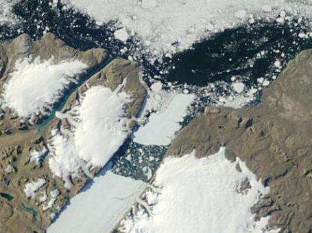
Rapid Melting of Greenland's Glaciers. Professor Jeff Masters and his amazing
Wunderblog focuses on some remarkable changes taking place in Greenland, including the recent calving of a massive iceberg last August: "
No humans were present on the morning of August 4, 2010, in a remote fjord in Northwest Greenland, when the air vibrated with a thunderous crack as one of the largest icebergs in world history calved from the Petermann Glacier, the island's second largest ocean-terminating glacier. Where the glacier meets the sea, a 43 mile-long tongue of floating ice existed at the beginning of 2010. On August 4 2010, a quarter of this 43 mile-long tongue of floating ice fractured off, spawning a 100 square mile ice island four times the size of Manhattan, with a thickness half that of the Empire State building. According to Andreas Muenchow, associate professor of physical ocean science and engineering at the University of Delaware's College of Earth, Ocean, and Environment, the freshwater stored in this ice island could have kept the Delaware or Hudson rivers flowing for more than two years, or kept all U.S. public tap water flowing for 120 days. There was speculation that the ice island could find its way into the open Atlantic Ocean in two years, and potentially pose a threat to oil platforms and ships. However, as the ice island made its turn to get from the narrow Petermann Fjord to enter Nares Strait between Greenland and Canada, the mighty iceberg split into thousands of small icebergs that will not pose an unusual threat to shipping when they emerge into the Atlantic.
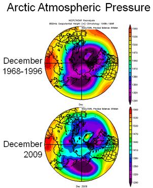
Warm Arctic - Cold Continents. A recent
article from NOAA: "
It’s a puzzle: How could warmth in the Arctic produce frigid conditions elsewhere? NOAA scientists may have a clue. Extremely cold winds have swept down through the Northern Hemisphere recently, reaching as far south as the state of Florida and causing record low temperatures in January. The unusually cold winter of 2009–2010 – which saw massive snowstorms dubbed “Snowpocalypse” and “Snowmageddon” — and the frigid start to 2011 in the eastern United States and Europe have scientists talking about what might be influencing the weather. Dr. James Overland, a scientist at NOAA’s Pacific Marine Environmental Laboratory (PMEL) in Seattle, has been studying the changing conditions in the Arctic for 30 years. He explains why the deterioration of the Polar Vortex could be leading to some of these extreme winter weather events. “When the Polar Vortex — a ring of winds circling the Arctic — breaks down, this allows cold air to spill south, affecting the eastern United States and other regions,” says Dr. Overland. “This can result in a warmer-than-average Arctic region and colder temperatures that may include severe winter weather events on the North American and European continents.”

No comments:
Post a Comment