1/10th of an inch of snow fell on Thursday.
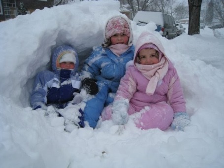
9" snow on the ground as of Thursday evening.
1999 last year the Twin Cities picked up a foot of snow or more in March (16" on March 8-9, 1999).
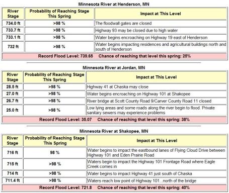
40% probability that flooding on the Minnesota River in Shakopee will reach the record flood stage of 721.8 feet, set in 1965
98.6" snowiest winter on record in the Twin Cities (1983-1984).
* If we just get "average" snowfall into April (nearly 14") this will be a "Top 3 Snowiest Winter" for the Twin Cities. We only need a little over 22" to set a new, all-time record for the snowiest winter in modern-day history.
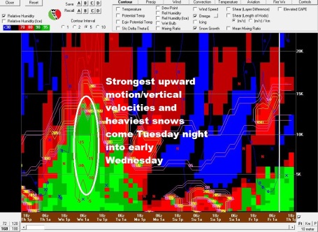
Weather Highlights (lowlights?): The weather looks relatively quiet today, Saturday and much of Sunday, any major storms detouring south of Minnesota. Light snow may arrive late Sunday, with a potential for an inch or two Sunday night into Monday. The storm we've been talking about for the past few days seems to be on-track for the middle of next week (heaviest snow probably falls Tuesday night into Wednesday). Confidence level is still low - but rising steadily. The models have been surprisingly consistent in printing out over 1" of liquid precipitation the middle of next week. With temperatures close to freezing in the lowest mile of the atmosphere the snow/rain ratio may be 10/1, maybe 12/1 Wednesday PM as the column of air overhead begins to cool on the backside of the storm. If the storm tracks across southern Iowa into northern Illinois or southern Wisconsin heavy snow bands may set up directly over southern and central Minnesota and much of northern/western Wisconsin. There is a potential for a foot of heavy, wet snow from this storm. Nothing is guaranteed (except sunrise/sunset), but I have a hunch this may turn out to be the first 12"+ storm for much of Minnesota since 1999. Stay tuned for more updates (4 computer runs/day). Enjoy the relative peace and tranquility. We'll probably make up for it next week.
"It looks like the storm of March 8-9 1999 of 16 inches is the last time there was a storm of 12 inches or more in the Twin Cities": http://climate.umn.edu/doc/journal/msp990308.htm
"There was a storm of 10.8 in March 14-15 2002": http://climate.umn.edu/doc/journal/snowstorm020314.htm
"There was also a 10.7 inch storm March 12-13 2006": http://climate.umn.edu/doc/journal/snow060312_13.htm
Snowfall By Midnight Sunday Night. The "main event" will probably arrive from Tuesday through Thursday morning of next week (Wednesday appears to be the snowiest day right now). But a series of smaller impulses out ahead of the main storm may drop a plowable snowfall on parts of the Dakotas and far west central Minnesota by Sunday night. The farther west you drive, the better the odds of running into a few inches of slushy snow late Sunday.
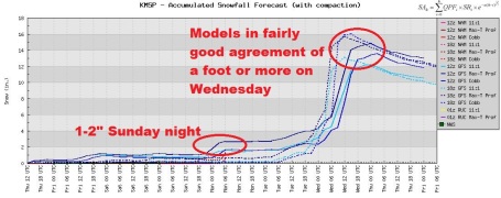
Big Numbers. Lot's of "Potential". The storm is still 5 days away, but the models are in surprisingly good agreement about the potential for a major snowfall the middle of next week. The heaviest snows are predicted from late Tuesday into Wednesday evening, flurries probably tapering off on Thursday. Is it definite? No, but with each passing computer run (we get 4 every day) the odds of a major snowfall rise steadily.
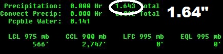
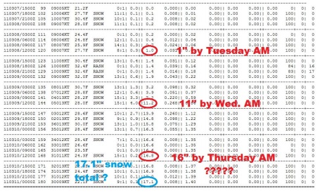
Big Numbers (continued). The latest GFS model prints out a total of 1.64" of liquid water between now and Wednesday evening. Roughly 1.55" of that is forecast to fall (as snow) from Sunday night into midday Wednesday. A brief changeover to rain or ice is possible (Tuesday), but models are still suggesting that MOST of the precipitation will fall as wet snow. Assuming a snow/rain ratio of 10/1, even 8/1 at the height of the storm Tuesday night and Wednesday morning, we could still wind up with 8-12" of snow (or more). A few towns may pick up closer to 12-15". Note to self: I'm just the messenger. I'm as anxious for spring as everyone else...
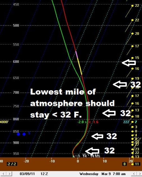
Cold Enough For Snow. Earlier runs brought a surge of warmer air aloft, with a few hours of freezing rain and sleet. The latest run keeps the temperature "sounding" below 32 F. throughout the lowest mile of the atmosphere, probably cold enough for all snow. We'll see - it's still early. Maybe the storm will take a detour to Nashville, or do a U-Turn and take aim at Dallas. Maybe I'm dreaming. Yes, we're going to see some heavy snow. 6"? 10"? 15"? Still too early to say, but it may rival the storm that struck in February, when nearly 14" caked the Twin Cities.
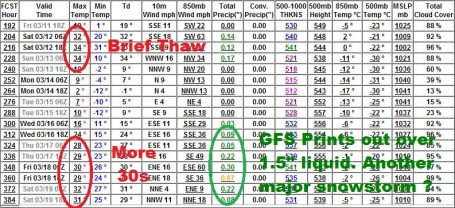
What Keeps Me Up At Night?. The GFS is holding back on any real warming trend - earlier runs were hinting at an extended thaw after the 15th or so - but the latest run prints out another major storm around March 18-19. It may be a fluke, but if we do wind up with another 1-1.5" liquid (falling as mostly snow) the subsequent flood risk will rise even higher. I hate to say this (out loud), but I have a very bad feeling about this year's flood scenario. I think it may wind up rivaling the record year of 1965 in many communities.
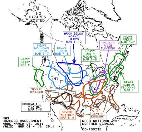
Alaska Is Looking Good. This is NOAA's "Hazards" map. Good grief - I can't remember a time when I saw this many threats, on one map. Flooding, tornadoes, drought, snowstorms. Something for everyone.
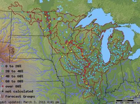
Updated Flood Forecast. The hydrologists (river forecasters) at the Chanhassen office of the National Weather Service have issued an update on the April flood potential - things continue to deteriorate, for a variety of reasons: unusually heat snow, high water content in that snowcover, high soil moisture levels, and a delayed thaw, which could mean rapid melting when spring warm fronts finally do arrive. For towns like Savage, Jordan and Shakopee there is now a 38-40% risk of flooding approaching the all-time record levels of 1965, which set the modern-day benchmark for severe flooding across much of Minnesota. I pray it doesn't get that bad, but I fear this year's flood season will probably be worse than any year since 1997. Here are some detailed forecasts from the NWS, more information here.
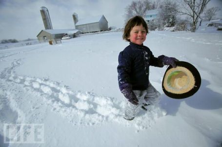
Snowier Than Average March? It's beginning to look like that, and come to think of it, why should this month be any different? The snowiest December on record, the 2nd snowiest "meteorological winter" on record - don't buck the trend, don't fight the pattern. Professor Mark Seeley seems to agree in this week's edition of WeatherTalk: "Since 1950 a modest to strong episode of La Nina (the cool water dominance in the central equatorial Pacific Ocean) has been in play 15 times during Minnesota's winter season. Such has been the case this winter as well. In ten of these 15 years March snowfall has been well above normal, averaging nearly 20.5 inches. Is this historical correlation a suitable predictor? Perhaps not, but it certainly appears our dose of snowfall will be significant through the first half of this March." (file photo courtesy of Life Magazine).
Seeley adds this about the spring flood potential:
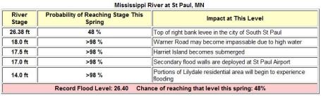
"The Mississippi River at St Paul has close to a 100 percent chance of reaching major flood stage, but more importantly there is close to a 40-45 percent chance of reaching the all-time flood crest of 26.40 ft (1965). A similar probability for a record flood crest exists for the Mississippi River at Hastings. Major flood stage is a 90 percent probability for the St Croix at Stillwater, and there is a 20 percent probability for a record flood crest (94.1 ft)."
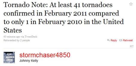
A Busy Tornado Season? America suffered through 41 tornadoes last month, compared with 1 tornado in February of 2010. La Nina events are often followed by unusually severe springs, with more tornadoes and hailstorms than usual. We'll go from heavy snow to mud/flooding to sirens within about 60 days. Something to look forward to.
Paul's Conservation MN Outlook for the Twin Cities and all of Minnesota:
TODAY: Mostly cloudy with a few flurries and a cool wind. Winds: NW 10-20. High: near 30
FRIDAY NIGHT: Patchy clouds, more flakes. Low: 17
SATURDAY: Leftover clouds, few flakes possible - no accumulation. High: 26
SUNDAY: Some sun early gives way to increasing clouds. Light snow possible PM hours. Low: 13. High: 28
MONDAY: Wet snow, around 1" possible. Low; 22. High: 34
TUESDAY: Light snow may mix with ice, rain at times - minor accumulations during the day. Heavier snow arrives Tuesday night. Low: 28. High: 35
WEDNESDAY: Heaviest snow falls, 6-12" close to home? Windy with potentially treacherous travel. Low: 28. High: 32
THURSDAY: Flurries taper, turning colder - travel slowly improves. Low: 16. High: 23
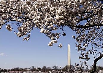
Early Bloom Predicted For DC's Cherry Blossoms. From USA Today:
WASHINGTON (AP) — "A National Park Service expert on Thursday predicted an early bloom for Washington's cherry blossoms, with warm temperatures already speeding the buds toward full bloom in late March. Chief Horticulturist Rob DeFeo said he believes the pink and white flowers will be at their best from March 29 to April 3, though the flowers can be seen in the days before and after those dates. The full bloom is predicted to fall in the middle of the National Cherry Blossom Festival, which runs March 26 to April 10. The average peak bloom date is April 4, according to the Park Service, so the first blossoms may come early this year. "I look at the buds, and it's like a pregnancy," DeFeo said of his prediction. "They go through these five stages — and the only variable is the temperature."
March Madness
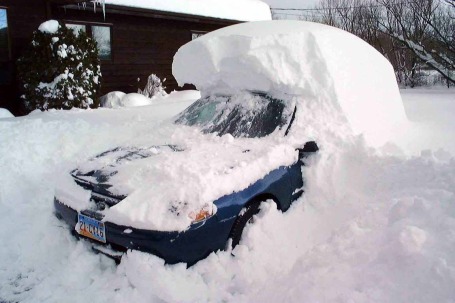
"Paul, the weather here has been beautiful! We just hit 70, the crocus are coming up, neighbors are golfing. I love spring in Washington D.C.!" Don't you just hate calls like this? My sister in law is counting the days until she can open up her pool. And here we sit, a state held hostage by Old Man Winter, facing yet another (potential) foot of snow next week.
We're stuck in a snowy rut, no question. 66.7" fell from December through February, the 2nd snowiest "meteorological winter" on record. Only 1966-67 was snowier. With nearly 5" liquid precipitation it was the 4th wettest on record, another reason why hydrologists are so concerned about river flooding roughly 1 month from now.
No short-term atmospheric gotchas lurking out there. The arrival of cooler air sets off flurries today, highs near 30F, 4 degrees below average. Saturday flurries give way to steadier snow late Sunday into Monday, but the timing has shifted. It now looks like the heaviest (wet) snow arrives Tuesday PM into Wednesday. It's too early to know where the heaviest snow bands will set up, or whether an icy mix will keep amounts down, but some 10-15" totals are very possible.
Time to call my travel agent.
Perth Has Hottest, Driest Summer On Record. La Nina created an environment for a much stormier winter for much of America, but Australia is experiencing near-record heat. An update from the BBC: "Perth has had its hottest and driest summer on record. Just 0.2mm of rain fell from the beginning of December to the end of February, compared to the average of 32mm. There were 59 days over 30 degrees centigrade, smashing the previous record of 53. There were also 15 consecutive nights where the minumum temperature did not fall below 20 degrees, breaking the previous record of 13 nights set in 1990. The average maximum temperature for the summer was a sweltering 32 degrees centigrade. So why has Perth had such an extreme summer? There has been a strong La Niña in the Pacific, which has led to the extreme rainfall in eastern Australia. This also tends to strengthen the easterly trade winds which blow hot dry air from the interior and reduce the number of weather systems moving in from the ocean, so western areas have been drier than usual."


No comments:
Post a Comment