* 9 days so far in 2011 with more than 100 tornado warnings. Last year (the entire year) there were only 2 days with more than 100 tor warnings.
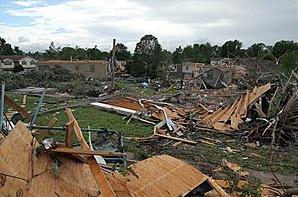
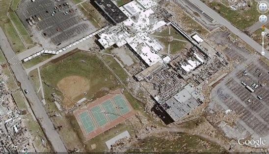
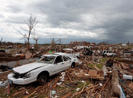
* 232 residents of Joplin are still listed as unaccounted for. The death toll stands at 125, the largest loss of life from tornadoes since 1947.
_________________________________________________
* Freeze warning in effect early this morning for much of northeastern Minnesota, including Duluth.
* .06" rain predicted tonight (NAM model). Much of today (daylight hours) should be dry.
* Much of the weekend should be dry: best chance of showers/T-showers late Saturday and Saturday night, another chance of showers and thunder over far southern Minnesota late Sunday.
* Slight severe storm risk on Monday, mainly over southern Minnesota.
* 80s expected the first weekend of June, shot at 90 a week from Sunday? (details below)

Freeze Warning on May 27? The northeastern third of Minnesota and much of central and northern Minnesota is under a freeze warning, meaning that several hours of sub-freezing temperatures are likely, potentially cold enough (long enough) to damage or kill annuals. More from the NWS office in Duluth:
URGENT - WEATHER MESSAGE
NATIONAL WEATHER SERVICE DULUTH MN
203 PM CDT THU MAY 26 2011

...NEAR AND SUB FREEZING TEMPERATURES ARE EXPECTED TONIGHT...

.HIGH PRESSURE OVER LAKE NIPIGON IS BUILDING OVER LAKE SUPERIOR
AND OUR AREA. LIGHT WINDS...CHILLY AND VERY DRY AIR AND CLEAR
SKIES WILL RESULT IN TEMPERATURES WELL BELOW FREEZING FOR SEVERAL
HOURS MOST AREAS TONIGHT. A WEAK ONSHORE FLOW WILL MODERATE
TEMPERATURES ALONG THE MINNESOTA LAKE SHORE TONIGHT. MORE
MOISTURE IN THE AIR AND POSSIBLE HIGH CLOUDS WILL MODERATE
TEMPERATURES TO NEAR FREEZING ACROSS THE BRAINERD LAKES AREA.
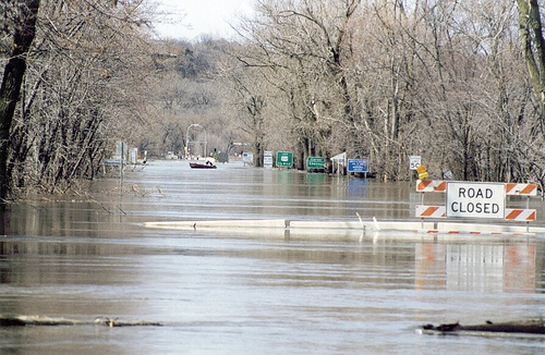
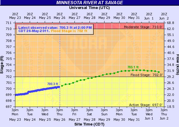
THE NATIONAL WEATHER SERVICE IN CHANHASSEN HAS ISSUED A FLOOD WARNING FOR THE MINNESOTA RIVER AT SAVAGE. (file photo above):
* FROM LATE SATURDAY NIGHT UNTIL FURTHER NOTICE.
* AT 9:00 AM THURSDAY THE STAGE WAS 700.2 FEET.
* MINOR FLOODING IS FORECAST.
* FLOOD STAGE IS 702.0 FEET.
* FORECAST...RISE ABOVE FLOOD STAGE BY EARLY SUNDAY MORNING AND CONTINUE TO RISE TO NEAR 703.1 FEET BY TUESDAY EARLY AFTERNOON. ADDITIONAL RISES ARE POSSIBLE THEREAFTER.
* IMPACT...AT 702.0 FEET...FLOOD WATERS BEGIN TO IMPACT BLACK DOG ROAD IN BURNSVILLE.
* FLOOD HISTORY...THIS LEVEL COMPARES TO A PREVIOUS LEVEL OF 702.8 FEET ON OCT 1 1986.
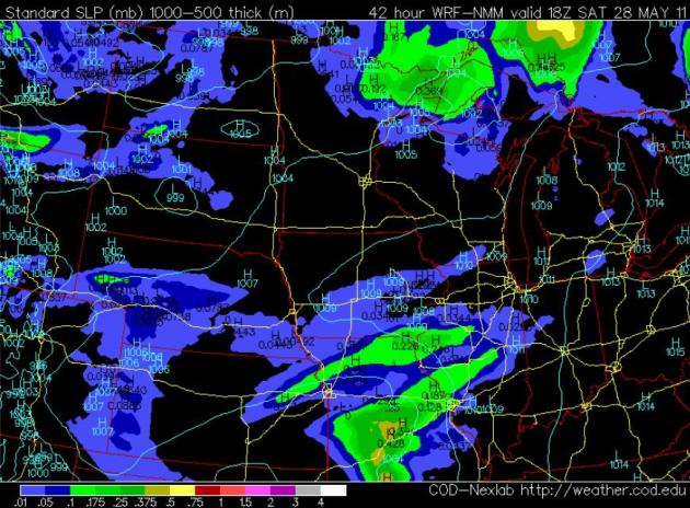
Saturday: Looking A little Better. After a damp start skies should clear Saturday, partly sunny conditions much of the day with a growing chance of late-day showers and T-storms, especially over far western Minnesota. But much of Saturday should be dry with highs ranging from mid 60s (north) to low 70s (south). NAM model image above is valid 1 pm Saturday, showing the best chance of morning showers on Saturday over the Minnesota Arrowhead.
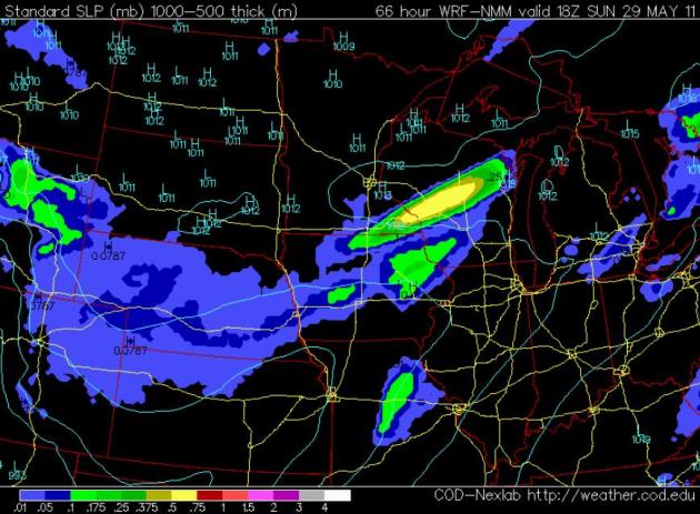
Dry Most Of Sunday. The nicest weather Sunday should come up north. The NAM forecast map (above) is valid 1 pm Sunday, showing dry weather over much of Minnesota. The only exception: southeastern Minnesota, where the risk of showers and T-storms will increase during the afternoon hours. A shower or T-storm can't be ruled out in the metro area late Sunday with a better chance of T-storms Sunday night into Monday as a warm frontal boundary pushes north.
Instant Summer? It's still a long-shot, but all the models I've looked at (GFS and European ECMWF) bring a surge of hot air (there's a new expression) into Minnesota by next weekend. 80s seem likely, even a slight chance of 90 a week from Sunday, on June 5. Yes, we're due for a real warm front. This is one of those year where summer isn't on a dimmer switch, more like an on/off switch. From jackets and frost to 80s and low 90s in a week? Sounds like Minnesota to me.
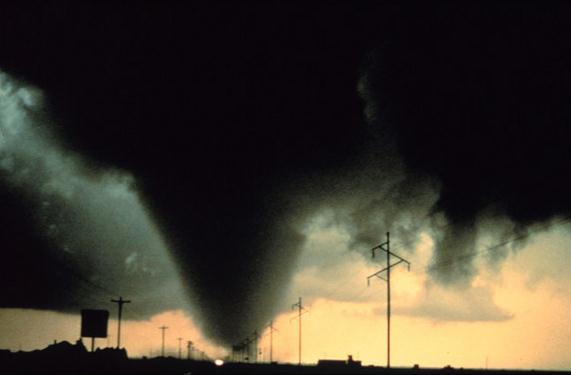
No Fatalities From Wednesday's Tornadoes. SPC reported nearly 80 tornadoes on Wednesday, but most were relatively small EF-0 to EF-2 strength, not the maxi-tornadoes, the massive wedge tornadoes that tore through much of the nation from Sunday through Tuesday. AccuWeather reports: "Just days after an EF-5 tornado devastated the town of Joplin, more twisters touched down across Missouri and other parts of the Mississippi Valley region on Wednesday, highlighting another busy day of severe weather. Several people were injured in association with numerous tornadoes on Wednesday, spanning 10 states from Ohio to Texas (also California). In addition, there were hundreds of separate reports of large hail and non-tornadic damaging wind gusts. Fortunately, there were no reports of any fatalities from Wednesday's tornadoes, highlighting successful and advanced severe weather warnings and forecasts. While severe thunderstorm and tornado activity was ongoing throughout much of the day over a wide area, the most prolonged cluster of dangerous storms progressed across Missouri from the late morning through the afternoon hours."
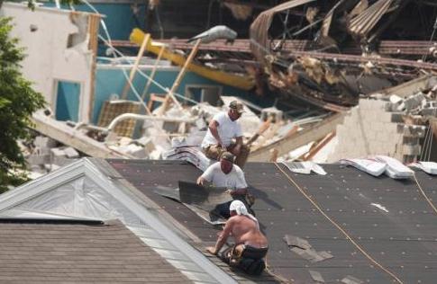
Storms Create Scramble To Install Shelters. If you don't have a basement this might be a good time to take a long, hard look at your home or apartment. Where would you go? Do you have a small, reinforced (interior) room where you could rideo out an extreme storm? Building a "safe room" (reinforced concrete/steel) costs a few thousand dollars, but many people are realizing this is a worthy investment for the long-term safety of their families, as reported in the New York Times: "What is on track to be the deadliest tornado season in the nation’s history has prompted record-breaking sales for companies that sell safe rooms and shelters designed to withstand the powerful storms that have killed hundreds of people this spring. From Minnesota to Texas — and especially in the tornado-ravaged South and Midwest — people are begging installers to get to their houses as soon as possible. “We are having such a bad season that people say, ‘I thought about it for two years and put it off, but now I really need to get one,’ ” said Alisa Smith, director of sales for the Arkansas branch of Family Safe Shelter. Her company is scrambling to install more than 40 shelters a day around the country. “Everybody would like to have one, and they want them yesterday,” she said. But only in select cases are people required to build them. Government regulations mandating storm shelters, either public or private, are inconsistent. There are some regulations for apartment buildings, and some states, like Minnesota and Kansas, require that shelters be built near mobile home parks. Many areas, like Williamson County in Illinois, commandeer churches or schools to serve as voluntary shelters."
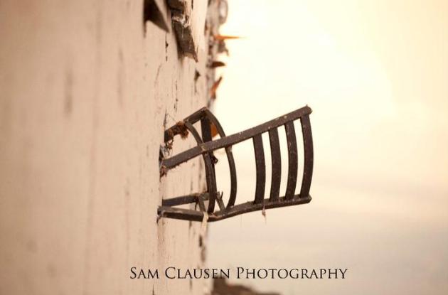
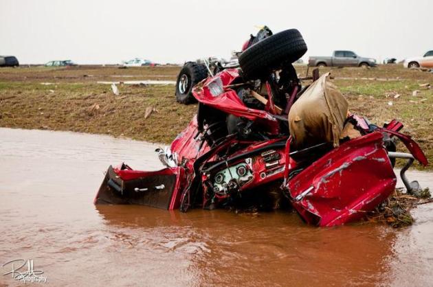
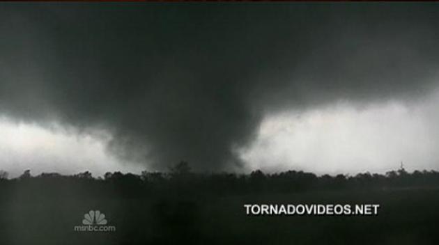
Evidence Of What An EF-5 Is Capable Of. Sam Clausen has captured a remarkable collection of photos from the Joplin tornado - available on Facebook here (you probably need a FB account to see these). He writes: "The wall of a nearby store was littered with trash including this chair. (Concrete wall)"
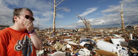
* 232 local residents of Joplin are still listed as missing. More details here.

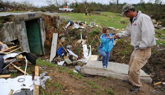
Search For Joplin Tornado Survivors Finds Few Amidst Debris. These stories are heartbreaking - I watched the father of this missing young man (who was driving home from his graduation ceremony) Wednesday night and tried to imagine what this poor guy was going through. Yahoo News and AP have the story: "JOPLIN, Mo. – Mike Hare has scoured the ravaged neighborhood where his 16-year-old son Lantz was seen last. He's called hospitals from Dallas to Kansas City and taken dozens of calls offering advice, prayers and hopeful tips. None of the calls came from Lantz. None offered any hope he might still be alive. Hare has been looking for his son since Sunday, when much of the southwest Missouri city of Joplin was leveled by the deadliest single tornado since the National Weather Service started keeping records. "We know he's hurt somewhere," Hare said Wednesday, his voice breaking. "We just can't sit and keep calling. You've got to be moving." Hare is among an increasingly desperate group of people in Joplin pleading for help in tracking down one of the dwindling number of people still missing in the wake of Sunday's storm. They're scrawling signs in wreckage, calling in by the hundreds to local radio stations and posting on the Internet. They are inspiring city officials to continue search and rescue efforts: there is no talk yet of recovery. Officials planned to release a list Thursday morning of people still considered missing. "I am hopeful," Joplin Fire Chief Mitch Randles said. "We've had stories from earthquakes and tsunamis and other disasters of people being found two or three weeks later, and we are hopeful we'll have a story like that to tell."
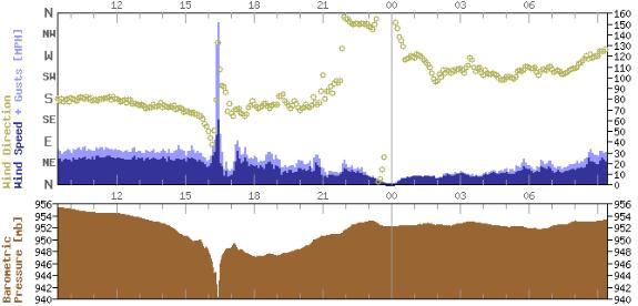
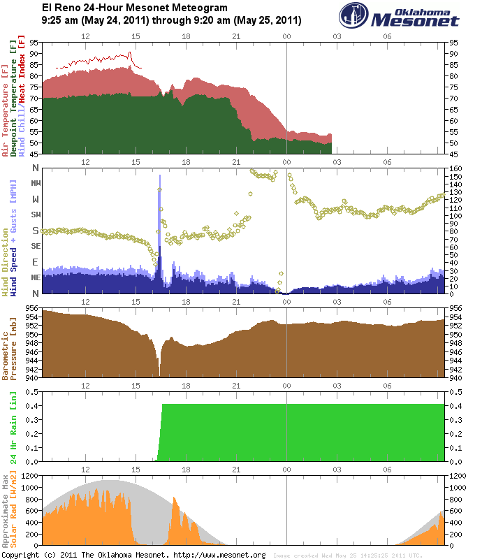
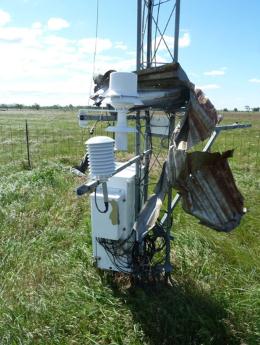
Anatomy Of A Tornado. Here is the raw data from the El Reno weather station, part of the Oklahoma Mesonet. Not the spike in winds around 4:30 pm on May 24 (wind gust to 150 mph), accompanied by a sharp drop in air pressure. Somehow the weather station survived the direct hit - something I've never seen before.
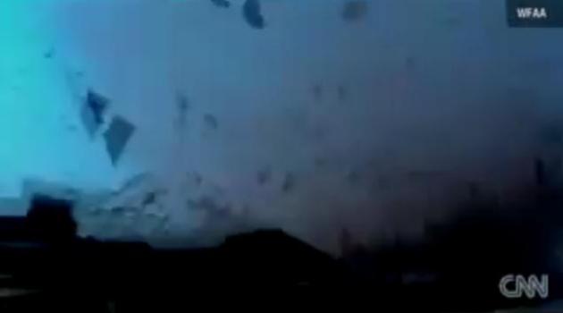
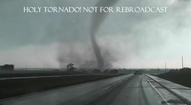
"We're IN The Tornado!" Here is some of the most incredible video I've ever seen, courtesy of Wunderblog, CNN and WFAA-TV in Dallas. Yes, this guy was a little too close: "Meyers rode out the tornado inside a vehicle and videotaped the twister as it tore the roof off a school about a block away. "We are in the tornado! We are in the tornado!" Meyers yells several times in the video. "The sheer power was just amazing," Meyers said in an interview Monday on CNN's "American Morning" program. The storm, which struck around 5:30 p.m. (6:30 p.m. ET), also turned over an 18-wheeler truck onto a passenger car, knocked 11 cars from a freight train off their tracks and caused extensive damage to Rice Elementary School, Navarro County Chief Deputy Mike Cox said."
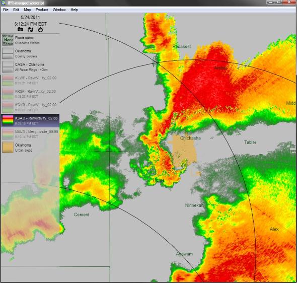
Classic Hook. At the center of the screen you can see the supercell thunderstorm that spawned the monster tornado near Chickasha, Oklahoma. Image courtesy of Brad Panovich from WCNC-TV and Twitpic.
Greensburg, IN tornado
http://www.youtube.com/watch?v=rSXuzd9PIOo
WV tornado
http://www.youtube.com/watch?v=HbYCXoOpu64
5/24 KS tornado
http://www.youtube.com/watch?v=PEC4YblyPdM
5/25 CA tornado
http://www.youtube.com/watch?v=HpCej6DUOPU
5/24 El Reno, OK tornado
http://www.youtube.com/watch?v=xwu7PqxjO74
Beaver tail/collar cloud over Memphis
http://www.youtube.com/watch?v=2DRcLqD3kEU
5/24 Twin Oaks, OK tornado
http://www.youtube.com/watch?v=Cs-FORCMMec
Canton, OK tornado
http://www.youtube.com/watch?v=33qlinKn5nc
TN wall cloud
http://www.youtube.com/watch?v=oIpsJzq1FPw
* Thanks to WeatherNation meteorologist Jason Parkin for tracking down these video clips from around the USA.
Joplin Tornado. NBC's Brian Williams interviews the Editor of the Joplin Globe newspaper. 7 of the reporters at the Globe lost their homes in last Sunday's terrible tornado, but there was no loss of life. The NBC clip has footage of the tornado, in addition to the interview.
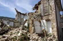
Italian Scientists Indicted On Manslaughter Charges For Not Predicting An Earthquake. Good grief - this is a troubling sign. What's next - failure to predict a storm, suing the local weather service for not catching that shower that rained out your baseball game? Predicting the future is perilous, in any profession. We can detect earthquakes with sophisticated monitoring systems - but there is still no way to accurate (reliably) predict them hours or days in advance. The first company that figures that out will be worth a few hundred billion, give or take. From geekosystem.com: "After a 6.3 magnitude earthquake hit L’Aquila, Italy in April of 2009, ravaging the city and killing 308 people, local authorities took the questionable step of prosecuting researchers on a scientific committee for failing to predict the earthquake. In March of 2009, after smaller quakes had hit the region, the committee president had concluded that “just because a small series of quakes has been observed” did not mean that a large quake would necessarily occur, and that the near occurrence of one was “improbable, although not impossible.” Infamously, the one government official on the committee appeared on television and said that “The scientific community tells me there is no danger, because there is an ongoing discharge of energy. The situation looks favorable,” and some residents “quoted those statements as the reason they did not take precautionary measures, such as fleeing their homes.” After the earthquake struck, prosecutors took these statements to mean that the committee had been downplaying the risk of a seismic occurrence, and charged the six seismologists and one government official on the committee with manslaughter, their reasoning being that the seismologists had indirectly caused the deaths of L’Aquila residents by not properly informing them about the risks of an earthquake. The seismologists have argued, with the strong support of the scientific community, that it is impossible for current science to predict future earthquakes."

Tech Talk Podcast: Vacation Apps. Planning on a few long trips in the car (or in the air) this summer? Nothing like loading up the right apps on your iPad, Nook or Kindle to keep the kids entertained in the back seat. The New York Times has a few suggestions: "Time to start getting ready for that summer vacation! On this week’s episode of Bits: Tech Talk, Bettina Edelstein, J.D. Biersdorfer and Pedro Rafael Rosado chat about mobile apps for travel on the road, in the air and with children. Ms. Biersdorfer offers suggestions to help with road trips, from apps that find quirky attractions to those that locate the best highway exits for pit stops. Ms. Edelstein looks at apps that can make life a little easier when things don’t go as planned, like those that help you monitor traffic, find information about flights and airport conditions and let you manage your itinerary in one place. Mr. Rosado, after conducting tests on the home front, reports on apps that can keep children from going bonkers in the car or hotel room. (For mom and dad, he says, the bathroom-finder Sit or Squat is indispensable.) The news roundup includes a new, paperback-sized touch-screen Nook e-reader, sneak peaks of new features for Microsoft’s Windows Phone 7, a study linking cellphone use and diminished male fertility and an explosion at an iPad factory in China and its impact. Ms. Biersdorfer’s tech tip is about subtitles on Netflix streaming videos."
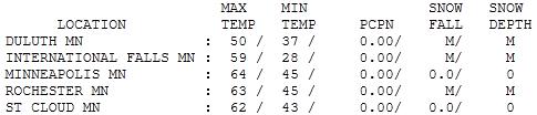

Brilliant Thursday. Under a shimmering-blue sky the mercury rose to 62 in St. Cloud, 64 in the Twin Cities, 65 at Redwood Falls. A raw breeze off Lake Superior kept the high at 50 in Duluth, a chilly 45 at Grand Marais. These temperatures are 10-15 degrees cooler than average, the result of an unusually strong (and chilly) bubble of high pressure centered north of the Great Lakes.
Paul's Conservation Minnesota Outlook for the Twin Cities and all of Minnesota:
TODAY: Sunny start, clouds increase PM hours. Still cool. Winds: SE 10-20. High: near 60
FRIDAY NIGHT: Light showers likely - still cool. Low: 50
SATURDAY: Damp start, then partly sunny and milder. A late-day shower or T-storm can't be ruled out, especially over far western MN. Winds: S 10-20. High: 71
SATURDAY NIGHT: Showers, possible thunder. Low: 57
SUNDAY: Best day of the holiday weekend? Partly sunny, breezy and mild. Showers and T-storms possible late Sunday and Sunday night, especially over southern Minnesota. Winds W: 10-15 High: 75
MONDAY: Humid, risk of a few strong/severe storms. Low: 59. High: 77
TUESDAY: Some sun, windy, turning cooler and less humid. Low: 63. High: 73
WEDNESDAY: Plenty of sun, light winds - best day of the week? Low: 56. High: 75
THURSDAY: Few showers, T-storms expected. Low: 58. High: 76
* 80s expected next weekend, even a shot at 90 by Sunday, June 5.
Weather Nightmares
The deadliest tornado since 1947 (Joplin). The most expensive tornado in U.S. history (Joplin). Most April tornadoes on record. The largest tornado outbreak on record (327 tornadoes in 21 states from April 26-28). 2011 has seen 9 days with more than 100 tornado warnings. Last year there were 2.
In spite of Doppler radar, continuous media coverage and heightened public awareness people are dying in huge numbers as massive "wedge" tornadoes plow into urban areas east of the Mississippi. We've seen four EF-5 tornadoes, top of the scale; the most since 1974.
What keeps me up at night? In spite of Sunday's EF-1 tornado in North Minneapolis I'm still concerned about a sense of false complacency among metro residents. "Tuscaloosa or Joplin couldn't happen here, right?" I hear that a lot.
A recent study of a hypothetical (large) tornado hitting the suburbs of Chicago at rush hour estimated a death toll of 3,000, with tens of thousands injured. The Boy Scouts are right: be prepared.
A sunny start gives way to increasing clouds, a few showers expected tonight. Much of Saturday should be dry, a late-day shower or T-shower can't be ruled out, especially far western Minnesota.
Skies may clear for much of Sunday, probably the best day of the holiday with highs in the low to mid 70s. A warm front shoves a few showers and T-storms into far southern Minnesota late Sunday - I can't rule out a few (isolated) severe storms by Monday.
The rumors are true: a hot front is brewing for the first weekend of June (finally!) Highs should reach the 80s, with an outside shot at 90 degrees 8 days from today, on Sunday, June 5. Remember how to sweat? Me neither.
* Others are more cautious about drawing a straight line between climate change and this year's record tornado outbreak:

Is Global Warming Causing More Tornadoes? Not So Fast. Discover Magazine interviews one of America's top scientists about a possible connection between the recent spate of (extreme) tornadoes and climate change: "Fortunately, being in Norman, I was also in the place to ask one of our country’s top experts this question—Harold Brooks, a tornado specialist at the National Severe Storms Laboratory. Along with other mainstream scientists, Brooks agrees that “it’s abundantly clear that the surface temperature has increased, and will continue to increase, and the overwhelming evidence is that it’s due to human activities.” Brooks also thinks global warming is likely to impact many weather phenomena–increasing the risk of heat waves, for instance, and stronger precipitation events. “But it doesn’t necessarily mean that every bad weather event is going to get worse,” Brooks continues, and when it comes to tornadoes, “I get really worried when people oversell the case.” After all, if we’re wrong and we go through a series of quiet tornado years in the coming years, it will be just another weapon with which to attack those who want climate action. You can read the rest of the piece–where Brooks elaborates on why he doubts tornadoes are increasing in number–here."
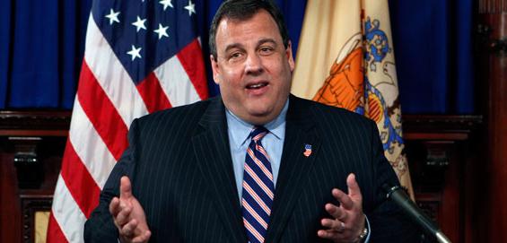
Chris Christie: Global Warming Is "Real", But Program Is Ineffective. A story in Politico: "Chris Christie wants it known he’s not a skeptic on global warming. Before the Republican New Jersey governor launched into an explanation Thursday for why he’s bowing out of a landmark regional cap-and-trade program for power plants, he first strapped on his layman scientist’s cap to give a brief overview of what’s widely considered accepted climate science. “In the past I’ve always said that climate change is real and it’s impacting our state,” Christie said at the start of a 14-minute prepared statement. “There’s undeniable data that CO2 levels and other greenhouse gases in our atmosphere are increasing. This decade, average temperatures have been rising. Temperature changes are affecting weather patterns and our climate.” Christie said he made his decision to pull the Garden State out of the Regional Greenhouse Gas Initiative following a 16-month internal review that included town hall meetings and private chats with climate scientists, academics and environmentalists. "I’m certainly not a scientist, which is the first problem," he said. "So I can’t claim to fully understand all of this, certainly not after just a few months of study. But when you have over 90 percent of the world’s scientists who have studied this stating that climate change is occurring and that humans play a contributing role, it’s time to defer to the experts."
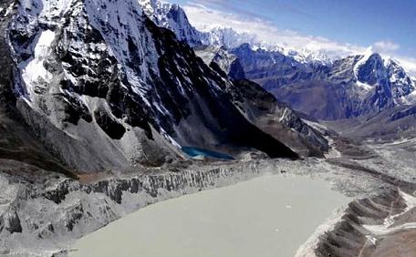
Everest Glacier "Turning Into A Lake" Due To Global Warming. A recent article in the U.K.'s Telegraph: "A study of glacial melting in the high Himalaya found that the Imja glacier has melted from solid ice in the mid-1950s to a one and a half mile long lake today. Scientists from Nepal's International Centre for Integrated Mountain Development (ICIMOD) said the lake is growing by just under 50 metres per year and is in danger of bursting its banks – a 31 metre-high dam of rocks and stones – and flooding nearby villages and trekking routes. They predicted that more than 7,500 people would be affected by the floods, including tourists hiking along the popular Everest Base Camp route. The study compared photographs taken from the 1956 Swiss Everest expedition, which showed no evidence of a lake on the glacier, to later pictures and revealed the creation of a large lake. "Photographs taken in the 1950s demonstrate that, except for several small melt ponds, no lake existed at that time. By 1984 a lake of approximately 0.4 square kilometres had formed," the report said."


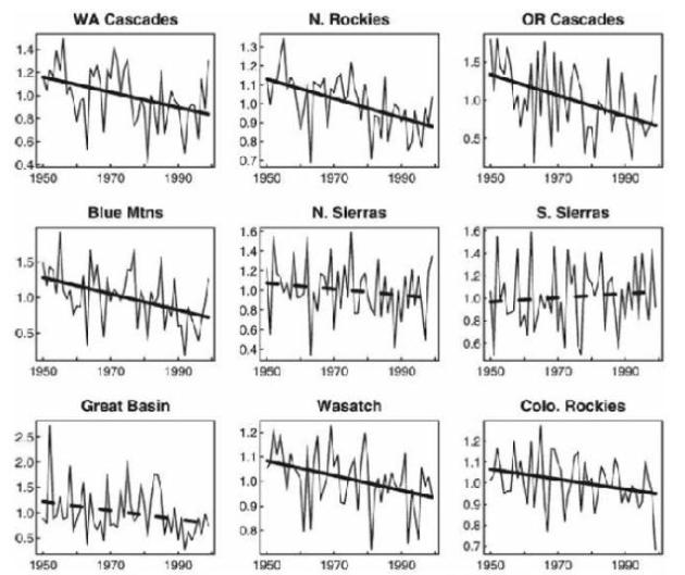
- "Decline in Snowpack Blamed on Warming"--headline, Washington Post, Feb. 1, 2008
- "Record Snowpacks Could Threaten Western States"--headline, New York Times, May 22, 2011

"If Chicago must prepare itself for having the climate of present-day Baton Rouge by 2100, one can only wonder what Baton Rouge is in for.
If global climate change proceeds as most mainstream climate scientists are now projecting, Baton Rouge, along with New Orleans and many other Gulf Coast cities, may actually become, if not uninhabitable, then barely habitable, hammered by heat, humidity and hurricanes to a degree unknown in their prior history.
The measures necessary to keep New Orleans alone from simply disappearing beneath the waves will be stunningly expensive, even assuming they work.
That’s why, although it makes sense to prepare for hot times in the old town tomorrow, it makes even more sense to get cracking immediately on efforts aimed at limiting climate change. (Forget about avoiding it altogether; that ship has sailed.)
Battening down the hatches against the coming climate storm without acting now and forcefully to temper its fury is a policy of resignation. And if the attitude takes hold that nothing can be done to prevent the changes forecast to occur over the next century, the only winners will be those whose short-term interests are served by doing nothing and who refuse to worry about the long term because when it arrives they’ll be dead anyway.
The rest of us, and our descendants, will end up footing the bill."
ERIC B. LIPPS
Staten Island, May 23, 2011
No comments:
Post a Comment