.11" rain reported yesterday at KMSP.
1" rain at Rochester Wednesday.
Bright sunshine today - predicted high of 65, nearly 10 degrees cooler than average for May 26.
.38" rain predicted Friday night (NAM model).
Sunday: probably the nicer day of the holiday weekend, highs in the low to mid 70s with PM sunshine.
Slight severe storm risk on Monday.

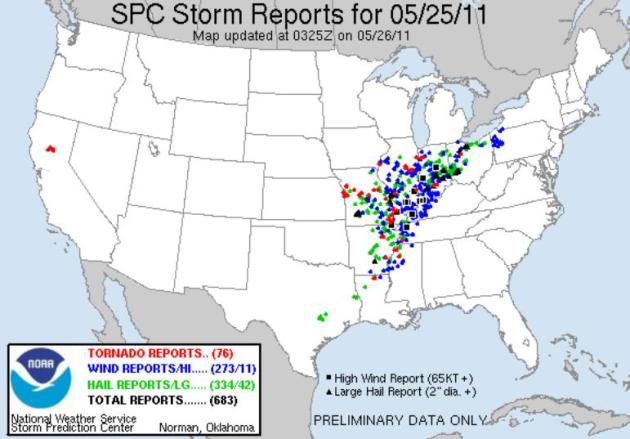
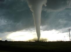
76 More Tornadoes Wednesday. The good news: most of the reported tornadoes were relatively small, not the EF-3 to EF-5 monsters that dropped from Sunday through Tuesday. More details from SPC.
Redefining The Meaning Of A Severe Spring:
April 4: Most severe storm wind reports on record
April 26-28: Largest tornado outbreak on record
Month of April: Most monthly tornadoes on record
May 22nd: Joplin, MO Tornado: deadliest since 1947
2011: Most tornado deaths Since 1953
* statistics courtesy of Dr. Greg Forbes at the Weather Channel.
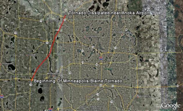
More Details On Minneapolis Tornado. Rated a strong EF-1 (with pockets of potentially weak EF-2 damage) last Sunday's tornado was on the ground for 6.25 miles in Hennepin county, another 8 miles in Anoka and Ramsey county before dissipating. More from the local NWS office:
WINDS OF 100 TO 110 MPH WERE PRODUCED BY THE TORNADO THAT HIT NORTH
MINNEAPOLIS...ST. LOUIS PARK...GOLDEN VALLEY...FRIDLEY...MOUNDS VIEW
AND BLAINE. IT WAS ON THE GROUND FOR SIX AND ONE QUARTER MILES IN
HENNEPIN COUNTY...PLUS AN ADDITIONAL EIGHT MILES ACROSS ANOKA AND
RAMSEY COUNTIES AS THE TORNADO WENT THROUGH PARTS OF FRIDLEY...
MOUNDS VIEW...AND BLAINE.

THE TOTAL PATH LENGTH WAS 14 AND 1/4 MILES.  THE TORNADO WAS ABOUT
1/2 MILE WIDE AT ITS WIDEST POINT.  THE TIME OF TOUCHDOWN WAS
APPROXIMATELY 215 PM...BUT THIS WILL BE FINE TUNED IN THE DAYS TO
COME AS MORE EVIDENCE IS GATHERED.  ACCORDING TO VARIOUS SECURITY
CAMERAS...THE TORNADO MOVED INTO FRIDLEY AT 222 PM.
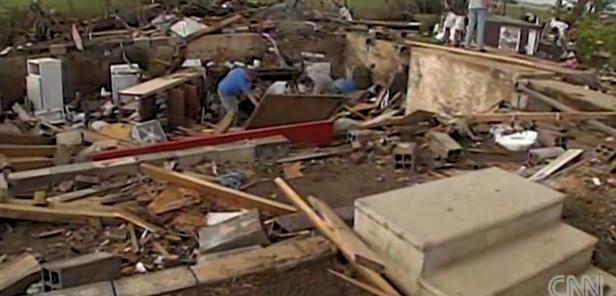
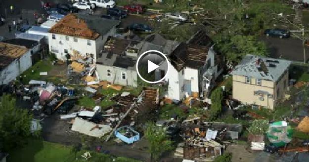
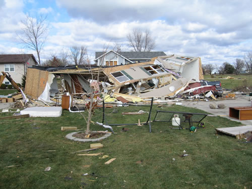
Nothing But Foundation. The same CNN video above had a section that made me catch my breath. Look at the photo above - the entire home was wiped off the pad, nothing left but the front (concrete) steps and the original foundation. This is what a rare EF-4 or EF-5 tornado can do. Unbelievable. This is why experts say that if a large/violent tornado is approaching and you can't get to a basement or below-grade shelter of some sort, your odds of surviving a direct hit are not very good.
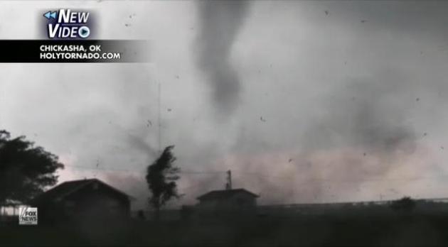
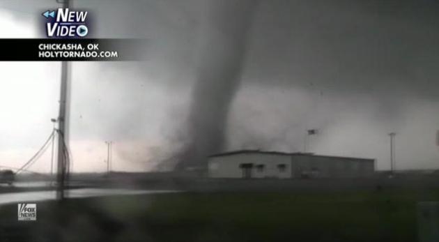
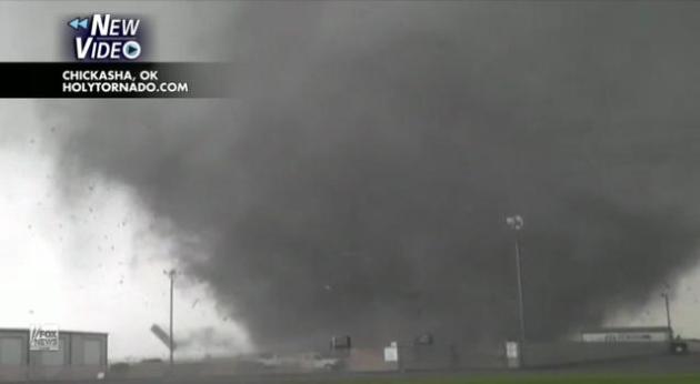
Tornado Videos:
South OKC tornado:
http://www.youtube.com/watch?v=TzvmEDTkGUM
El Reno, OK tornado:
http://www.youtube.com/watch?v=RMRT1eEC5Ac
http://www.youtube.com/watch?v=ObaFO3QcRA0
http://www.youtube.com/watch?v=nCPPngoBLwM
Piedmont OK tornado:
http://www.youtube.com/watch?v=E6DDUTRT4ok
http://www.youtube.com/watch?v=i4lBv8QCs4o
Tornado from DFW airport (at around 1:20)
http://www.youtube.com/watch?v=EdIQ3OyYfLI
Cleveland Co., OK tornado
http://www.youtube.com/watch?v=6dIl_Ijtq8Y
Canton, OK tornado
http://www.youtube.com/watch?v=wtXcokAzE98
Ft. Worth tornado
http://www.youtube.com/watch?v=PTSS-27nMdY
http://www.youtube.com/watch?v=ouaxUfn3Xbo
* Thanks to WeatherNation meteorologist Jason Parkin for sharing these video clips.http://www.youtube.com/watch?v=TzvmEDTkGUM
El Reno, OK tornado:
http://www.youtube.com/watch?v=RMRT1eEC5Ac
http://www.youtube.com/watch?v=ObaFO3QcRA0
http://www.youtube.com/watch?v=nCPPngoBLwM
Piedmont OK tornado:
http://www.youtube.com/watch?v=E6DDUTRT4ok
http://www.youtube.com/watch?v=i4lBv8QCs4o
Tornado from DFW airport (at around 1:20)
http://www.youtube.com/watch?v=EdIQ3OyYfLI
Cleveland Co., OK tornado
http://www.youtube.com/watch?v=6dIl_Ijtq8Y
Canton, OK tornado
http://www.youtube.com/watch?v=wtXcokAzE98
Ft. Worth tornado
http://www.youtube.com/watch?v=PTSS-27nMdY
http://www.youtube.com/watch?v=ouaxUfn3Xbo
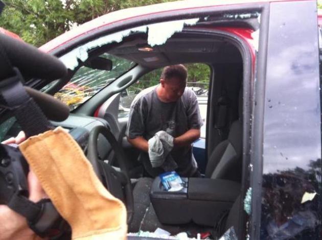
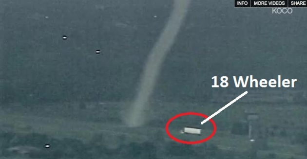
Tornado Picks Up Truck With Man Inside. It sounds like something out of the movie "Twister", but it was a terrifying reality for a Kansas man on Wednesday, as reported by KCCI-TV in Des Moines: "LOUISBURG, Kan. -- A man said that he was caught in his Ford F-150 pickup truck when the storm hit late Wednesday morning and lifted the truck into the air, reported KMBC-TV in Kansas City.

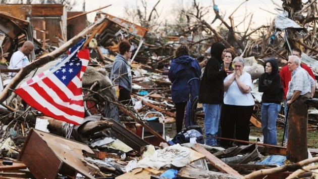

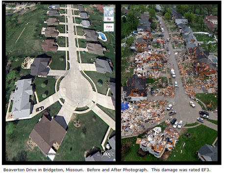
Joplin: Before And After The EF-5 Tornado. The New York Times has an amazing interactive graphic that shows the destructive fury of what happened last Sunday; well-constructed homes, nursing homes and businesses swept away. Virtually nothing left but rubble.
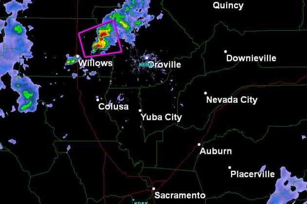
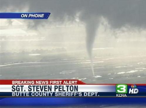
Rare California Tornado. Not to be left out of the tornado-mania, a twister was observed in northern CALIFORNIA late Wednesday, as reported by KCRA-TV in Sacramento: "Watch video from LiveCopter 3 HD of a tornado forming and touching down near Durham, Calif."
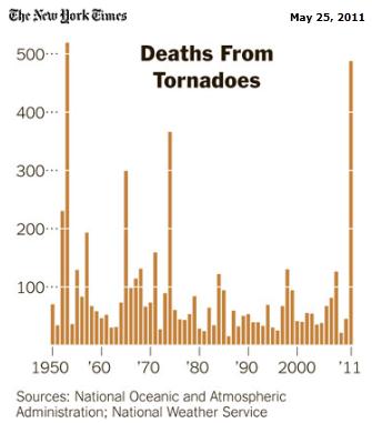
"Q: How bad has this year’s tornado season been, relative to other years?
A: Extraordinarily bad, even by historical standards. The death toll, now at more than 480, is the highest since 1953, when an outbreak of twisters across the Midwest and the Northeast claimed 519 lives. The high death toll this year is all the more remarkable considering that early warning systems are in place throughout tornado country, made possible by the advent of Doppler radar. Many tornado experts believed that the advances in technology had greatly diminished the risk of mass tornado fatalities. “We never thought there’d be another year of deaths like this, with all our warning systems,” said Thomas P. Grazulis, a tornado historian. Since 1875, there have been just 15 years with more than 360 tornado deaths, and none since 1975. The single deadliest tornado year in the United States was 1925, with 794 fatalities. This year now ranks eighth on the list of deadliest tornado years."
1. Bring your home insurance policy up to speed. If you live in an area prone to flooding, tornadoes, or hurricanes, I am going to assume you are well-versed in what isn’t covered in your standard homeowner’s policy, and what requires special riders and additional policies for wind damage.
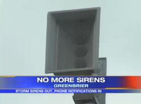

Recent e-mail to the Star Tribune about weather apps:
"Paul Douglas said in his column that he has a good mobile app to give tornado warnings. But I looked on his blog page and there aren't any specifics. Can you post the address for the app?"
Kris
Hi Kris,
The weather apps I referred to on the weather blog are:
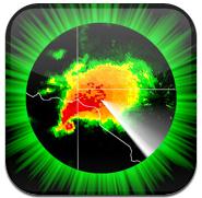
1). Radarscope. Best app for tapping into the NWS network of Doppler radars around the USA. It also shows where warnings are, in map-form (but no alerts to your phone).
2). My-Cast Weather Radar. This app allows you (for about $10) to upgrade to alerts, which sends advisories, watches and warnings to your iPhone. Not sure if there’s an Android version, but this is the best app I’ve found to get warnings on your Apple device. It also allows warnings to be sent to your current GPS location – lightning alerts too (if there’s a strike within 5 miles of any of your favorite locations).
Hope this helps – good luck!
Paul
Paul Douglas
WeatherNation LLC

Air War: It's TV Vs. Phones In Washington's Explosive Broadband Battle. Adweek has the story of a Battle Royale brewing between phone carriers and broadcasters for the Ultimate Prize: communications spectrum: "It’s a battle that has it all: power, money, entrenched interests, and a fair share of snark. It’s the spectrum war, where two of the major sets of players in the media business—the broadcasters and the telecoms—are battling over how to divide a path to consumers that the TV guys have controlled for decades. The broadcasters are the ones carrying the scars, having already been forced two years ago to surrender 25 percent of the airwaves they held, when the federal government’s long-planned, long-delayed conversion from analog to digital TV finally went through. In this fight they, and their representatives at the National Association of Broadcasters, have been cast as the old guard, desperately trying to ward off change despite the fact that, thanks to the spread of cable and satellite, only about 40 million out of their 300 million-strong American audience comes to them exclusively via the airwaves these days. It’s almost an accident that the telecoms are the new wave here—after all, the two biggest companies, Verizon and AT&T, have roots reaching all the way back into the 19th century, when Ma Bell was born. But as mobile phone guys they’re the upstarts, embodying the future with their explosive growth and cool toys (the iPhone and iPad, the BlackBerry, the Internet itself). Their futuristic sheen makes them the favored industry of the moment for Obama, as well as at the FCC, where chairman Julius Genachowski has been a friend of the president’s since their days working together on the Harvard Law Review."
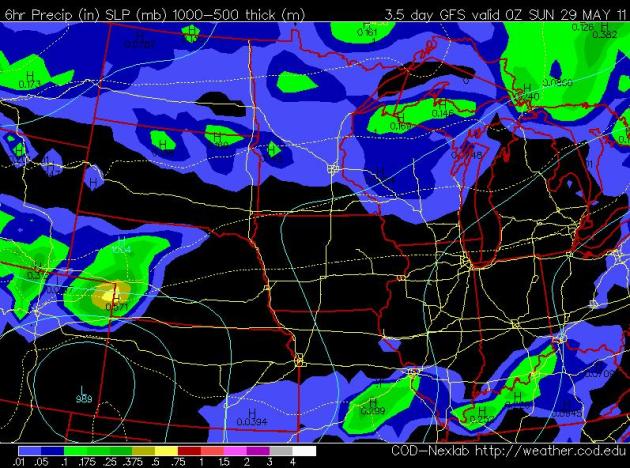
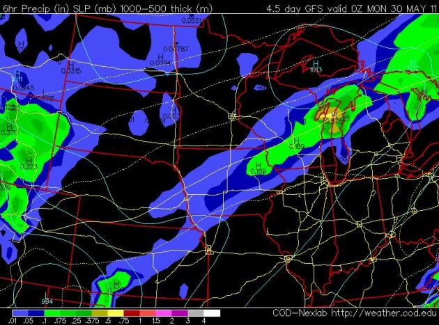
Unsettled Saturday. The heaviest rains should come late Friday and Friday night, a damp start Saturday giving way to intervals of sun. But a pocket of cold air aloft (vaguely similar to last weekend) may spark a few PM showers and T-storms - a few could be strong. The chance of PM showers Saturday will increase the farther north you go. The map above is valid at 7 pm Saturday evening, showing accumulated rainfall amounts for the preceding 6 hours, from 1 pm to 7 pm.
Better Sunday? This weekend won't be a weather-bargain by any stretch of the imagination, but the sun may be out midday and afternoon hours Sunday as the heaviest showers and T-storms push into Wisconsin and Iowa, highs in the mid 70s.
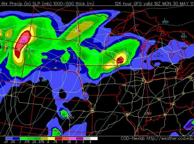
Severe Monday? It's still too early to say with any confidence, but we may have many of the ingredients necessary for a few severe storms close to home Monday: a warm frontal boundary over southern Minnesota, sufficient wind shear and an unstable airmass overhead. The way things are going this spring to our south I'm understandably nervous about 80 degree air and 65 degree dew points lurking just to our south. I still believe it's going to be another above-average late spring/summer for severe weather (and tornadoes) across Minnesota. Hope I'm wrong with that forecast.
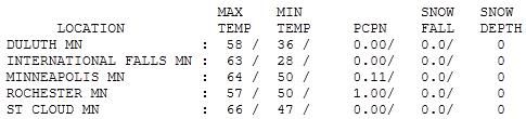

Brisk Wednesday. The Twin Cities metro got nicked by the same southern storm that whipped up heavy rain over southern Minnesota (1" in Rochester) and tornadoes as close as Missouri. Clouds kept temperatures cooler, only 64 in the Twin Cities, 66 in St. Cloud - a brisk 49 at Grand Marais.
Paul's Conservation Minnesota Outlook for the Twin Cities and all of Minnesota:
TODAY: Bright sun, cool breeze, very nice. Winds: NE 10-15. High: 65
THURSDAY NIGHT: Mostly clear and chilly for late May. Low: 43
FRIDAY: Clouds increase, PM rain likely. High: near 60 (holding in the 50s most of the day).
SATURDAY: Unsettled, few PM showers possible. Winds: SW 10-20. Low: 52. High: 71
SUNDAY: (probably the better day of the holiday weekend). Wet start, PM sun possible. Winds: NE 5-10. Low: 57. High: 74
MONDAY: Scattered T-storms, some severe? Low: 62. High: near 80
TUESDAY: Clearing, turning less humid, still pleasantly warm. Low: 65. High: 81
WEDNESDAY: Partly cloudy, temperatures near normal. Low: 59. High: 78
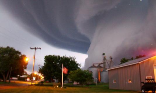
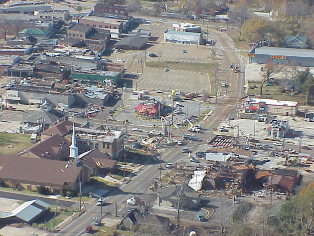
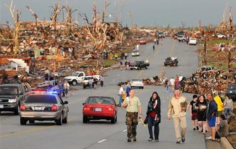
Tornado Tales
There is no way to build a cost-effective tornado-proof home. However, making buildings more tornado-resistant is possible, but only for the smaller EF-0 to EF-2 twisters. Nothing will survive a direct hit from a mile-wide EF-5. Thankfully less than 1% of all U.S. tornadoes are EF-4s or EF-5s.
The #1 danger: flying debris. Seeking shelter under a table, beneath the stairs in your basement ensures your survival, even if the house caves in. The more walls between you & the tornado the better. A small room (bathroom or closet) on the ground floor offers some protection. People have lived through EF-5 tornadoes by hiding in their bathtubs (with helmets on!) I know, a crazy mental image, but if a 200 mph whirlwind is approaching you get creative in a hurry. Do NOT open up windows to try to relieve air pressure. This increases the risk of injury from flying glass and leaves your home more vulnerable to damage.
Severe sunshine returns today, a cool breeze - but no complaints. Rain is most likely late Friday & Friday night, again Saturday night. A stray shower is possible Saturday afternoon; the best chance of a few uninterrupted hours of sun Sunday afternoon/evening. We're due.
Tornadoes! Floods! Droughts! Scientists Say Its Global Warming. A recent story from the Kansas City Star: "The deadliest tornadoes in decades. Severe flooding on the Mississippi River. Drought in Texas, and heavy rains in Tennessee. What's up with the weather? Scientists say there are connections between many of the severe weather events of the past month and global warming. "Basically, as we warm the world up, the atmosphere can hold more moisture in it," said Anne Jefferson, an assistant professor in the geography and Earth science department at the University of North Carolina, Charlotte. "Weather patterns that used to be limited to the South move farther north now," she said. "Both of those things together will increase the frequency with which we see these big rainstorms, and those are likely to increase flooding in the future." Flooding on the Mississippi has become more frequent and more extensive since about 1950, Jefferson said. This year's huge flood was created by snowmelt and rain-on-snow in the upper Mississippi River basin, and very intense rain in its middle regions. "Climatically we have a higher frequency of rain-on-snow events, a real recipe for flooding," she said. "Also you're getting more warm moist air from the Gulf of Mexico farther north up the Mississippi. It's both a warming and, more so, the fact that the weather patterns have changed and are projected to continue to change, so the precipitation patterns are changing." All of these changes are part of the general shift in the world's climate known as global warming - primarily the result of billions of tons of heat-trapping gases released into the atmosphere from burning fossil fuels, as well as deforestation. A report by the National Academy of Sciences on managing climate risks put it this way: "Climate change is occurring, is very likely caused primarily by the emission of greenhouse gases from human activities, and poses significant risks for a range of human and natural systems."
U.S. Extreme Weather Consistent With Climate Change. Is a warmer, wetter atmosphere super-sizing our storms? Is this just a symptom of a fading La Nina, or are other factors in play? More research is necessary - but climate scientists believe what we're seeing is consistent with what they've been predicting for the better part of 30 years. Voice of America has the story: "The powerful tornadoes and other extreme weather events that have cut swaths of destruction across the United States over the past month have prompted many to wonder if they are part of a new trend. Are these violent storms the result of climate change, or can they be explained as normal weather variations? This has been a record year for tornadoes in the United States. North America seems to be especially hard hit. "We have probably the most tornadoes when you think about the square mileage where we get them," says David Imy, operations chief at the National Oceanic and Atmospheric Administration’s Storm Prediction Center, "and also the more intense tornadoes and the reasoning happens to be the Rocky Mountains." According to Imy, the Rocky Mountain range prevents moisture from the Gulf of Mexico from spreading westward and forces it to concentrate over the midsection of the country. "Also it gives us dry air aloft that comes in and makes it more favorable for severe storms and tornadoes," says Imy, adding that the more than 200 tornadoes in the past month alone is an anomaly, "… compared to many other years that we’ve looked at. It’s hard to say that there is any trend in what we’re seeing this year. And so far we haven’t seen any differences in other parts of the world."
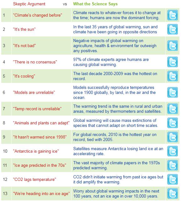
Skeptic Arguments And What The Science Says. Have a favorite climate denier in your life? Here is some scientific ammunition to debunk their favorite arguments, which continue to be regurgitated around the Internet, courtesy of skepticalscience.com: "Here is a summary of skeptic arguments, sorted by recent popularity vs what science says. Note that the one line responses are just a starting point - click the response for a more detailed response. You can also view them sorted by taxonomy, by popularity, in a print-friendly version, with short URLs or with fixed numbers you can use for permanent references."
No comments:
Post a Comment