TODAY: Morning/midday sun (PM clouds, few thundershowers central and north?) Dew point: 54 Winds: W 10. High: 77
SATURDAY NIGHT: Gradual clearing, quite comfortable. Low: 58
SUNDAY: Partly sunny, isolated PM shower. Dew point: 52 Winds: NW 10. High: 76
MONDAY: Plenty of sun, sticky and warmer again. Dew point: 63. Low: 63. High: 84
TUESDAY: Few showers, T-storms (esp. south and west). Low: 67. High: 87
WEDNESDAY: Clearing trend, less humidity. Low: 69. High: 85
THURSDAY: Lot's of sun, hints of September in the air. Low: 65. High: 79
FRIDAY: Partly sunny, thunder late? Low: 63. High: 78
84 F. high in the Twin Cities Friday.
70s today and Sunday, few pop-up PM showers possible both days.
50-55 : dew points today and Sunday will be typical for early September - very comfortable (but unstable) air floating over Minnesota.

Tropical Storm Harvey. I am enjoying the new crop of names: Gert, Harvey, next up: Irene! Tropical Storm Harvey's 50 mph winds brushed the northern coastline of Honduras late Friday, expected to weaken rapidly over Central America in the coming days, still capable of some 10-15" rains. Map courtesy of NHC and Ham Weather.
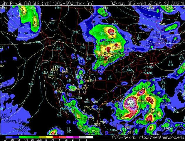
Hurricane Irene? It's still (wildly) speculative, and the track will most assuredly change (several times) between now and the end of next week. But the GFS model continues to bring a tropical storm across the Carribean, possibly brushing south Florida before (possibly) entering the Gulf of Mexico late next week. The map above shows a hurricane centered just south of Mobile, Alabama next Sunday morning at 1 am. The accuracy of an 8 day forecast? Not good, but the models have been fairly consistent bringing "something" into the Caribbean late next week. Stay tuned...
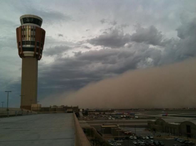
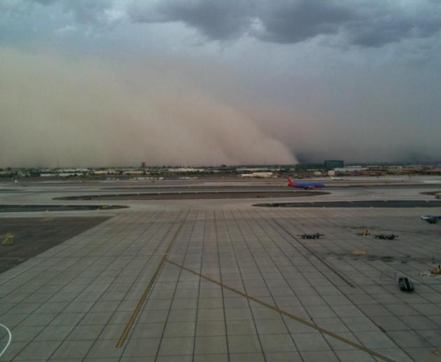
Another Haboob! Thanks to Elizabeth Garcia, who sent these photos of the latest haboob (massive sandstorm) to invade the Phoenix metro area late Thursday. Elizabeth sent these photos into our WeatherNation FB page - we appreciate it!

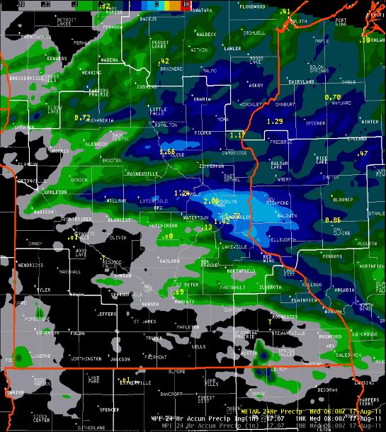
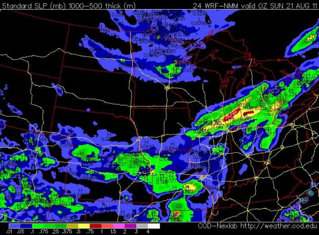
Today: Sunny South, PM Clouds/Showers North. The best chance of seeing the sun today: morning and midday hours. A swirl of cold air aloft will spark a few instability showers, even a few stray T-showers, up north later today, a couple hours of showers possible from the far north metro to Mille Lacs and the Brainerd Lakes area. Winds: W 8-13, dew points in the 50s.
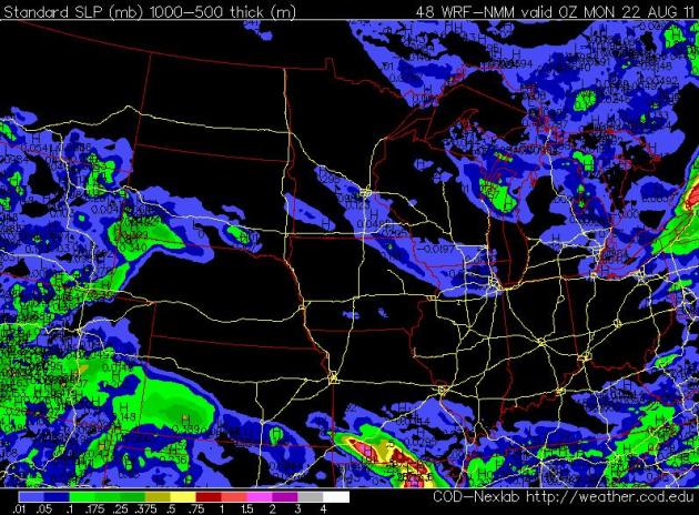
Sunday: "Dirty High". Once again the best chance of a few hours of blue sky tomorrow will come during the morning and midday hours, a few PM showers may sprout over central and southern Minnesota. Highs: 70s, with winds from the west/northwest at 8-13.


The American Identity According To Social Media. PCmag.com has a fascinating article about our obsession with social media, British royalty, and celebrities of every size, shape and color: "For example, I had no idea that 65 percent of all social media content relating to the British royal wedding derived from the United States, even though it it apparently shattered records for online traffic. (That benefited Yahoo, by the way.) And though we've touched upon Farmville and its creator, Zynga, from time to time, the amount of hours gamers put into it is amazing: more than 63 million active users spend an average of 15 minutes per day pretending to run a farm. Over the course of a year, that's 5,475 minutes, or the equivalent of two weeks at a full-time job by a single user. Yikes. And Americans are nostalgic: the average Facebook user has 229 friends. According to Hasai, less than 10 percent are college friends, more than 20 percent are friends from high school. Oh, and as you head to your vacations, keep in mind that the Jersey Shore is likely to be filled with tanned tweens tapping away at cell phones. That's because New Jersey is second in friend requests, the study found, second only behind North Dakota. Maybe that's because nobody wants to go outside during the winter?"
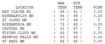
Better-Than-Average Friday. Yes, the sun was out most of the day, a few showers popping up over central Minnesota during the late afternoon hours, spreading into the Twin Cities metro late Friday evening. Highs ranged from 72 at Alexandria to 77 at St. Cloud, 84 in the Twin Cities and 85 at Eau Claire, WI.


Weather Ramblings
"When all is said and done, the weather and love are the two elements about which one can never be sure," wrote Alice Hoffman. Amen to that. “Conversation about the weather is the last refuge of the unimaginative,” according to Irish poet Oscar Wilde. I disagree.
Weather is one of the few things that unites all of us (along with muttering about the Twins, Vikes & Gophers). Weather is the pond in which we live - it impacts our schedules, our commutes, recreation plans, even the food on our dinner table. Minnesotans have a God-given right to brag (and complain) about the weather. What a summer: record humidity levels & especially severe storms; every other day some nearby town seems to get whacked by a tropical downpour.
The atmosphere overhead is shifting gears, another welcome whiff of September in the air, as dew points drop into the 50s. A cool pool of air aloft may set off a few PM instability T-showers (best chance north of Lake Mille Lacs). Sunday looks a bit sunnier & drier with low humidity - once again a stray shower may sprout by late afternoon. No 90s in sight, no widespread severe outbreaks, no storms (with names). "Irene" may approach Cuba or even Florida within 6 days. Yes, there may be plenty to talk about next week.




Critters Moving Away From Global Warming Faster. The story from Yahoo News and the AP: "WASHINGTON (AP) — Animals across the world are fleeing global warming by heading north much faster than they were less than a decade ago, a new study says. About 2,000 species examined are moving away from the equator at an average rate of more than 15 feet per day, about a mile per year, according to new research published Thursday in the journal Science which analyzed previous studies. Species are also moving up mountains to escape the heat, but more slowly, averaging about 4 feet a year. The species — mostly from the Northern Hemisphere and including plants — moved in fits and starts, but over several decades it averages to about 8 inches an hour away from the equator. "The speed is an important issue," said study main author Chris Thomas of the University of York. "It is faster than we thought." Included in the analysis was a 2003 study that found species moving north at a rate of just more than a third of a mile per year and up at a rate of 2 feet a year. Camille Parmesan of the University of Texas, who conducted that study, said the new research makes sense because her data ended around the late 1990s and the 2000s were far hotter."
Photo credit: The image (above) provided by Stanford University biologist Scott Loarie, shows an American Pika in Aug. 2008 in Desolation Wilderness in El Dorado County, Calif., near Lake Tahoe. Animals across the world are fleeing global warming by moving north and up twice as fast as they were less a decade ago, a new study says. About 2000 species examined are moving away from the equator at an average rate of more than 15 feet per day, about a mile per year, according to a giant study of new and old research in the journal Science published Thursday. Species are also moving up mountains to escape the heat, but more slowly, averaging about four feet a year. (AP Photo/Scott Loarie)
No comments:
Post a Comment