Freeze Warning issued for the Twin Cities Thursday morning.
Paul's Conservation Minnesota Outlook for the Twin Cities and all of Minnesota:
TODAY: Some sun. Winds: N 10-15. High: 58
WEDNESDAY NIGHT: Freeze warning tonight. Clearing skies with diminishing winds. Winds: SW 5-10. Low: 33
THURSDAY: Frosty 'burbs early? Bright sun, milder by afternoon. High: near 60
FRIDAY: Plenty of sun, frost-free. Low: 42. High: 62
SATURDAY: Clouds increase, drier day? Low: 52. High: 68
SUNDAY: More clouds, few showers possible. Low: 57. High: 73
MONDAY: Isolated shower or sprinkle, drier day. Low: 59. High: 74
TUESDAY: Intervals of sun, probably dry. Low: 56. High: 69

What September? O.K. Here's the deal, it will be a quick, glancing blow of cold air, 24 fairly uncomfortable hours, with the lowest temperatures coming Thursday morning. NOAA has central and southern Minnesota under a Freeze Warning (closer the center of high pressure), with a Freeze Watch north of Brainerd.
Thursday Morning Freeze. With the exception of the immediate downtowns and close-in suburbs, much of the Twin Cities metro may experience a freeze - at least 3 hours colder than 28. If you live outside the 494/694 beltway you may want to consider covering up your flowers or bringing them inside, if possible.
* Yes, this is happening 2-3 weeks earlier than usual. And no, it doesn't automatically mean a colder/snowier winter is imminent.

Exhibit A: Brown Caterpillars. I received this anonymous photo from a weather enthusiast, convinced that (brown) caterpillars are a hopeful sign that maybe (maybe!) the winter won't be as bad as everyone is expecting. La Nina? La Schmeena!

Tuesday Record Highs:
Del Rio, TX 101
San Antonio, TX 100
Austin, TX 105
Victoria, TX 104
Corpus Christi, TX 102
Houston 102 ***latest and earliest 102 days in a year (2011) *******
College Station, TX 103
Lufkin, TX 105
Tyler, TX 106
Longview, TX 107
Oklahoma City, OK
Texarkana, AR 106
Shreveport, LA 107
*****All bold: Hottest temps ever recorded this late in any year on record****
Monroe, LA 99
Springfield, MO 99
Joplin, MO 100
Mcalster, OK 104
Dallas, TX 107 ****Breaks most 100 degree days. Now at 70, was 69 set in 1980.
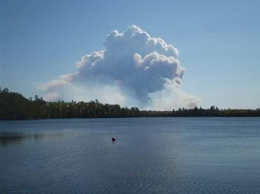
MN Arrowhead Fire Update. "This photo provided by Visit Duluth Public Relations, smoke fills the sky from a fire outside the borders of the Boundary Waters Canoe Area near Ely, Min. on Sept. 11, 2011. The Pagami Creek forest fire has more than tripled in size since Sunday and has grown to cover more than 16,000 acres. The blaze has forced Lake County and Superior National Forest officials to close several county and Forest Service roads north of Minnesota Highway 1 between Ely and Isabella. Some residents and campers are being asked to evacuate the area. (AP Photo/Visit Duluth Public Relations, Gene Shaw)." The Green Bay Press Gazette has moer details: "ELY, Minn. — A forest fire is now spreading outside the borders of the Boundary Waters Canoe Area near Ely and getting closer to homes and cabins. The Pagami Creek forest fire has more than tripled in size since Sunday and has grown to cover more than 16,000 acres. The blaze has forced Lake County and Superior National Forest officials to close several county and Forest Service roads north of Minnesota Highway 1 between Ely and Isabella. Some residents and campers are being asked to evacuate the area."
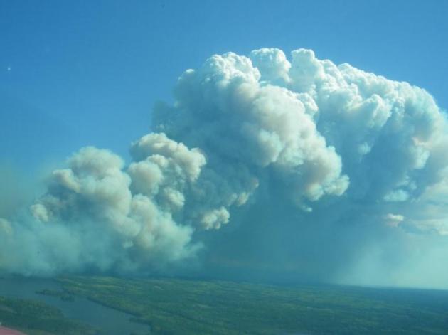
Fire Details.Details from inciweb.com:
DATE OF DETECTION: August 18, 2011
CAUSE: Lightning
CURRENT SIZE: approximately 11,000 acres acreage is expected to increase today due to weather conditions.
LOCATION: Township 63 N, Range 9 W, Sections 30, 31, 32: approximately 14 miles east of Ely (within the Boundary Waters Canoe Area Wilderness) in the Pagami Creek area between the South Kawishiwi River, Clearwater Lake, and Lake One.
AGENCY: Superior National Forest, Kawishiwi Ranger District
SMOKE CONDITIONS: Smoke may be heavy and wide spread depending on wind direction.
RESOURCES: A 20 person Minnesota Incident Command System crew of firefighters arrived last night. Another crew is on order. Yesterday, we received assistance from a Canadian air tanker. A helicopter and a CL-215 air tanker are at the Ely tanker base.
CLOSURES: Most of the BWCAW remains safe and open to visitors. To insure public safety the following waterways and portages are closed: Lakes One through Hudson, Fire, Bridge, Rifle, the Wilders, Horseshoe, Pagami, Clearwater, Turtle, Camdre, Pietro, Gull, Quadga, Rice, Isabella Lake, and the Isabella River. The southern campsites on Bald Eagle are closed. The Pow Wow Trail is closed. The following entry points are closed: #30 Lake One, #84 Snake River, #75 Little Isabella River, #67 Bog Lake, #86 Pow Wow Trail, #35 Isabella Lake, and #34 Island River. Today, campsites on the southern end of Insula Lake will be added to the closures. Sites, routes and portages will be re-opened as soon as it is safe to do so.
SAFETY: Public Safety crews will be working with campers in nearby lakes including Insula to advise them of safe travel routes. Campfire restrictions are in place. In the entire BWCAW campfires are allowed only between 6 p.m. and midnight. Be sure that campfires are doused thoroughly until cold to the touch.
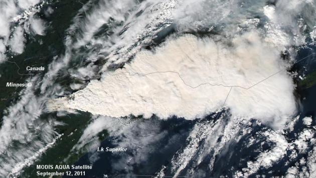
Smoke Plume From Space. Here is NASA's Aqua satellite image of the Pagami Fire, taken on Monday, September 12. Photo courtesy of the Twin Cities office of the National Weather Service.
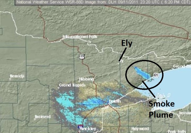
Smoke Plume On Doppler Radar. NWS Doppler out of Duluth on Monday showed the Pagami Fire plume east of Ely.
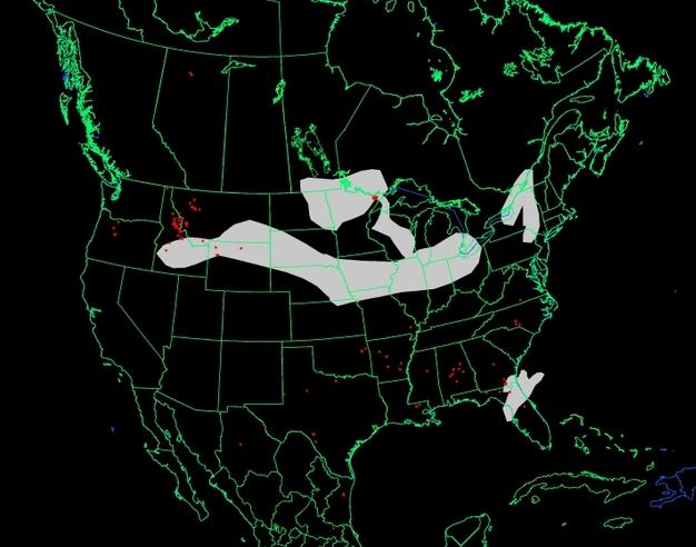
Outlook: Partly Smoky. Using this tracking tool from NOAA you can see the smoke plume originating over the BWCA of northeastern Minnesota. A second smoke plume just south of Minnesota is originating from wildfires over Idaho, Montana and Wyoming.
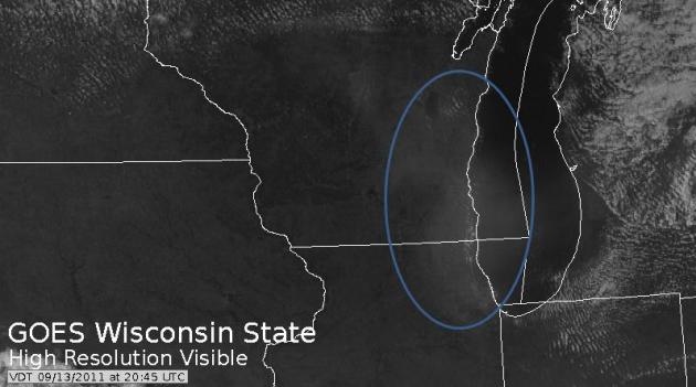
BWCA Fire = Breathing Difficulties In Chicago. Here's more information from the Chicago office of the NWS on the pall of smoke that dropped visibilities in the Chicago area, prevalent enough to cause watery eyes and difficulty breathing in some neighborhoods. Here's a statement from the Chicago NWS.
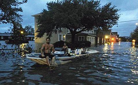
The 10 Worst Weather Disasters This Year And Why They Are Happening. Alternet.com has the story: "All these events have taken their toll on the country, both in terms of human lives lost and the amount of damages incurred. FEMA's disaster fund has dipped so low it is having to divert funds from Joplin, Missouri, site of the heartbreaking May tornado, to areas clobbered by Irene. The National Climatic Data Center (NCDC) reports that we've already set a record of 10 disasters over $1 billion each this year-- and it's only September.
So how bad have things been, and what's to blame? Let's take a look at the NCDC's list of wreckage of the last nine months.
1. Ground Hog Day Blizzard, Jan 29-Feb 3
It may be hard to think back to the frigid days of winter, but the massive storm that blanketed central and eastern states was a killer. It put Chicago under several feet of snow, claimed 36 lives and caused losses over $2 billion. The storm stymied travel, exhausted plowing budgets, and brought major cities to a standstill. For New York, the storm capped a month of snowfall that hit 36 inches."
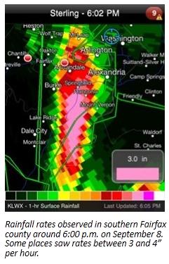
Virginia Deluge: A 1 In 1,000 Year Flood? Here is more information on the incredible rainfall rates observed in Virginia last Thursday (remains of Tropical Storm Lee). Details from Think Progress and the Capital Weather Gang: "The disinformers like to say the extreme weather we are seeing today is nothing unusual. They don’t live in Texas, where “No One on the Face of This Earth has Ever Fought Fires in These Extreme Conditions.” Or my hometown area around the Catskill Mountains, where Hurricane Irene was “the most devastating weather event ever to hit the region.” Or around Binghamton, NY, where “An Extreme Rainfall Event Unprecedented in Recorded History Has Hit.” Capital Weather Gang Chief Meteorologist Jason Samenow has the details on one more record-exploding extreme event in this repost. On Thursday, September 8, Ft. Belvoir received an astounding 7.03” of rain in three hours. According to the National Weather Service (NWS), that amount of rain in that amount of time was an “off the charts above a 1000-year rainfall (based on precip frequency from Quantico).”
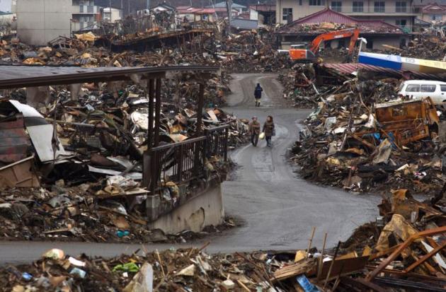
Japan Quake: 6 Months Later. Here is a remarkable video essay from The Atlantic, focusing on the regions of Japan devastated by the massive quake and tsunami in March: "Sunday, the world commemorated the 10th anniversary of the 9/11 attacks on the United States, but Sunday had another significance for Japan. It marked six months since the massive earthquake and tsunami on March 11, a date now seared in the country's national consciousness. At 2:46 that afternoon, a 9.0 magnitude earthquake struck Japan offshore, triggering a tsunami wave of up to 10 meters (33 ft) that engulfed large parts of northeastern Japan and also damaged the Fukushima nuclear plant, causing the worst nuclear crisis in decades. The current number of dead and missing is estimated to be 22,900. Gathered here are some recent images from the region, including 12 before-and-after photo pairs (starting with photo number two) that you can click to see the difference six months can make."
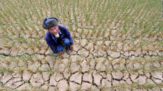
Drought In Southern China Impacting 44 Million People. Details from CNN: "A historic drought in southern China has caused billions of dollars in losses to agriculture and left millions of people and animals short of drinking water, government officials said Tuesday. And with no significant rain forecast for the next 10 days, there's no relief in sight, according to the National Meteorological Center. The impact of the drought, which began in June, is being felt across four provinces, affecting more than 44 million people, Ministry of Civil Affairs said. The direct economic loss is estimated at RMB 28.6 billion, or US $4.5 billion. In Guizhou province, it's the worst drought in 60 years, affecting 21.5 million people, the ministry said. More than 7 million people and 3 million cattle are short of drinking water. The drought has damaged 1.8 million hectares (4.4 million acres) of farmland, according to the ministry."
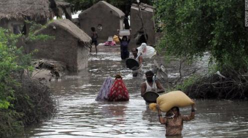
Severe Flooding Leaves 226 Dead In Pakistan. Here's a post from EverythingWX: "Bouts of extremely heavy rain over the last month have led to severe flooding across Pakistan (especially southeastern Pakistan), leaving at least 226 dead. The Sindh province has been hit the hardest, and even though they will only see a few scattered showers over the next couple of days, heavy rain across northern Pakistan will cause more flooding problems. The hardest hit area thus far has been Mithi in the southeastern Sindh province. Mithi has picked up 1,342 mm (~53″) of rain in since August 10th. 812 mm (~32″) has come since September 1st. This tremendous amount of rain is extremely abnormal, even for the monsoon season. The average rainfall for an entire monsoon (July through September) season in Mithi is 100-200 mm, or 4-8 inches of rain."
Ocean Storms And The Science Of Nature's Power. Voice of America has a good overview of the science of tropical cyclone formation, with a history of how hurricane's got their names. Here's an excerpt: "A storm with a misleadingly pleasant name recently brought death and destruction to parts of North America. Wide, slow-moving Hurricane Irene began to organize over the Lesser Antilles Islands in the Caribbean Sea. Later Irene gained strength. The storm stretched about one thousand seven hundred seventy kilometers along the eastern United States. Its destructive winds and heavy rain reached far inland. Even after it weakened, Irene carried disaster as far north as Quebec and Nova Scotia in Canada. A storm survivor in New England made a prediction as he repaired storm damage to his property. He said he believes fewer people will name their children “Irene” after this storm. Something similar happened after Hurricane Katrina struck the south central United States in two thousand five. America’s Social Security Administration says far fewer parents named their newborn daughters Katrina in the years immediately after the storm.
SHIRLEY GRIFFITH: People have called some natural events by human names for centuries. For example, the name “Thor” was given to the mythical Norse god of thunder, the loud sound that follows lightning in the sky. An Australian scientist began calling storms by women's names before the end of the nineteenth century. During World War Two, scientists called storms by the names of their wives or girlfriends. American weather experts started to use women's names for storms in nineteen fifty-three. In nineteen seventy-nine, they began to use men's names, too."
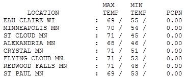
Cooling Down. Tuesday was a transition day, the high of 70 in the Twin Cities only 3 degrees cooler than average. Statewide highs ranged from 68 at Alexandria to 71 at St. Cloud and Redwood Falls.

Freeze Warning
This is happening way too fast. It was 90 on Monday - how could we be looking at a frost/freeze tonight? It may have something to do with the fact that - today - the sun will be as high in the sky as it was on March 27. Yep, we've lost some serious sunlight since late June. If skies clear and winds subside some of the coldest nooks and crannies of the MSP metro may wake up to a candy-coating of frost Thursday morning. Right now I don't expect a frost or freeze in the downtowns, but just outside the 494/694 beltway: all bets are off. BTW, the average first frost at MSP? October 3.
Some good news: there's convincing data showing that Minnesota's autumns are longer (and milder) than they were a generation ago. The last 10 Novembers have been warm enough to play golf, which is unprecedented looking at long-term climate records.
Dig out a jacket for tomorrow morning, but you'll still get some mileage out of shorts and T-shirts in coming weeks.
Clouds increase by Saturday, a few (rain) showers drifting across the state Sunday. It's sad that I have to spell out r-a-i-n, but MSP has seen flurries in late September. Any frost will kill ragweed - some good news for allergy sufferers.

Diamond Planets, Climate Change And The Scientific Method. A poignant story from Australia's "The Conversation": "Recently my colleagues and I announced the discovery of a remarkable planet orbiting a special kind of star known as a pulsar. Based on the planet’s density, and the likely history of its system, we concluded that it was certain to be crystalline. In other words, we had discovered a planet made of diamond. Following the publication of our finding in the journal Science, our research received amazing attention from the world’s media. The diamond planet was featured in Time Magazine, the BBC and China Daily, to name but a few. I was asked by many journalists about the significance of the discovery. If I were honest, I’d have to concede that, although worthy of publication in Science, in the field of astrophysics it isn’t that significant. And yet the diamond planet has been hugely successful in igniting public curiosity about the universe in which we live. In that sense, for myself and my co-authors, I suspect it will be among the greatest discoveries of our careers. Our host institutions were thrilled with the publicity and most of us enjoyed our 15 minutes of fame. The attention we received was 100% positive, but how different that could have been.
How so? Well, we could have been climate scientists."
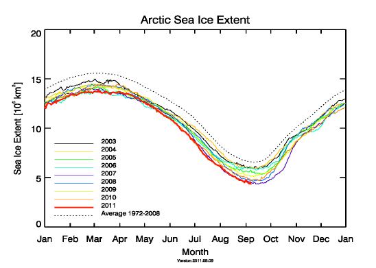
Arctic Sea Ice Reaches Record Minimum. Breaking news from the top of the world: "Alerting message from the Arctic: The extent the the Arctic sea ice has reached on Sep. 8 with 4.240 million km2 a new historic minimum (Figure 1). Physicists of the University of Bremen now confirm the apprehension existing since July 2011 that the ice melt in the Arctic could further proceed and even exceed the previous historic minimum of 2007. It seems to be clear that this is a further consequence of the man-made global warming with global consequences. Directly, the livehood of small animals, algae, fishes and mammals like polar bears and seals is more and more reduced."
Canadian Study Blames Ocean Acidity For Mass Extinction. The story from canada.com: "A Canadian-led team of scientists may have solved the biggest whodunit in Earth history in a study showing that the all-time greatest mass extinction on the planet — which wiped out about 90 per cent of all species 250 million years ago — appears to have been linked to rising levels of ocean acidity. Researchers have long believed that massive volcanic eruptions in present-day Siberia — or possibly a huge meteorite strike — triggered the so-called Permian-Triassic extinction. But the precise mechanism of death for so many species remains a subject of debate, with some scientists convinced it was a resulting lack of oxygen in the Earth's oceans or a greenhouse-gas nightmare that nearly ended all plant and animal life. But the Canadian study, headed by St. Francis Xavier University climate scientist Alvaro Montenegro, points to ocean acidification as a possible "main culprit" in the harrowing, prehistoric die-off."
No comments:
Post a Comment