90 F. high in the Twin Cities on Monday.
73 F. average high for MSP on September 12.
Frost possible by Wednesday night over central Minnesota, as close to the Twin Cities metro as St. Cloud.
Paul's Conservation Minnesota Outlook for the Twin Cities and all of Minnesota:
TODAY: Partly sunny, windy and cool. Winds: NW 10-20+ High: 67
TUESDAY NIGHT: Patchy clouds, still chilly. Low: 44
WEDNESDAY: More clouds than sun. Jackets and sweatshirts? Brisk! High: 58
THURSDAY: Frost possible north/west of St. Cloud. Bright sun, less wind. Low: 39. High: 59
FRIDAY: Plenty of sun, a bit milder. Low: 44. High: 64
SATURDAY: Mix of clouds and some sun. Low: 50. High: 68
SUNDAY: Patchy clouds, passing shower? Low: 55. High: near 70
MONDAY: Few showers, milder. Low: 58. High: 73

Wind Power = Ubiquitous in Europe. I'm just back from a week in Germany, France and Austria (tagged along with my 81 year old dad, who made it a point to see EVERY relative we still have other there in 7 days or less). We put on nearly 2,500 miles on the various Autobahns in about a week (Dad never met a rest stop or "Rasthof" he didn't like). Everywhere I turned there were wind turbines and wind farms, stretching as far as the eye could see. Also, many 300-600 year old homes had solar panels on their rooftops - pretty impressive how Europeans seem to be embracing alternative energy sources.
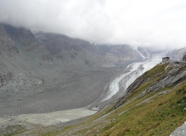
Shrinking Glaciers. Here is another image that is going to stick with me for awhile, a photo of the Grossglockner Glacier (The Pasterze). You see the photos, but until you see the melting glaciers up close it's hard to get a real feel for how much they've retreated in recent decades - they're now just a dark, stubbly shadow of what they were just 20-30 years ago, according to some of the locals I talked to in Austria.
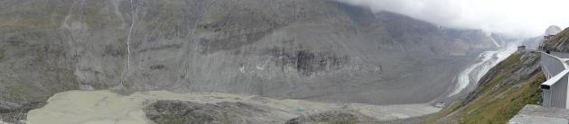
More Mud Than Glacier. Another (panorama) shot of the Grossglockner glacier, called "The Pasterze". If you ever get to Germany or Austria take a small detour and drive the Grossglockner Highway. At an elevation of over 11,000 feet the view is incredible, and the hairpin turns are nothing less than a religious experience behind the wheel. Tap the brakes (and pray they still work) when you come back down into the valley.
2011: 3 times more weather disasters, nationwide, than average (NOAA).
"So many heat records of various types have been shattered this past summer that it is impossible to quantify them," he said. "Not since the great heat waves of 1934 and 1936 has the US seen so many heat-related records broken as occurred this summer. The back-to-back nature of the intensity of the past two summers should raise some interesting questions, questions I am not qualified to address."
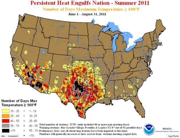
100-Degree Days. According to NOAA there have been more than 70 days above 100 (black-shaded area) from southern California into southern Arizona and much of Texas.
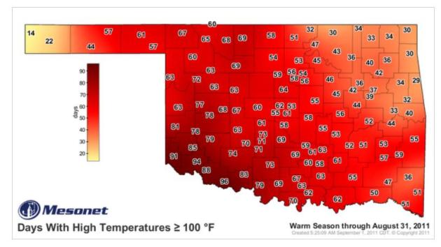
Summer of 2011 Was NOT "OK". Oklahoma simmered under as many as 96 days above 100 over southwestern counties. Think about that: over 3 months of daytime highs above 100. Map courtesy of the Oklahoma Mesonet and madweather.com. No, it's not always a "dry heat".
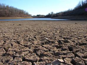
- August 2011 was a dry month across much of Minnesota. It was especially dry in the northeast, and in southern Minnesota counties. August rainfall totals in many areas fell short of the historical average by one to three inches.
- Rainfall totals in many northeast and southern Minnesota counties for the past six weeks totaled only one to two inches, a negative departure from the long-term average of three to four inches. When compared with the same six-week period in the historical database, 2011 late-July through early-September rainfall totals rank among the lowest on record in some locales.
- Topsoil moisture across 30 percent of Minnesota's landscape is considered to be "Short" or "Very Short".
- Stream discharge values remain high to very high in western and central Minnesota watersheds. The Red River of the North at Fargo fell below flood stage on August 27th. This reporting station had been above flood stage for 150 days in 2011. Conversely, stream flow in far northern Minnesota is quite low.
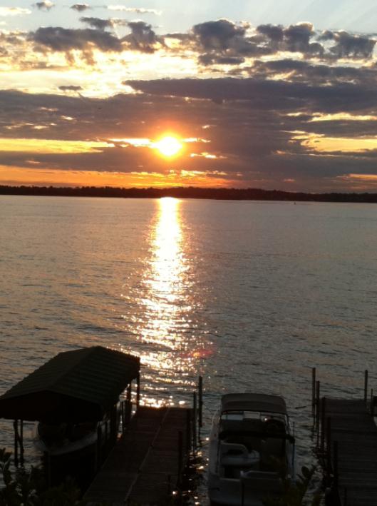
- Due to above-average growing season rainfall, many west central and central Minnesota lake levels are quite high relative to historical early-autumn values.
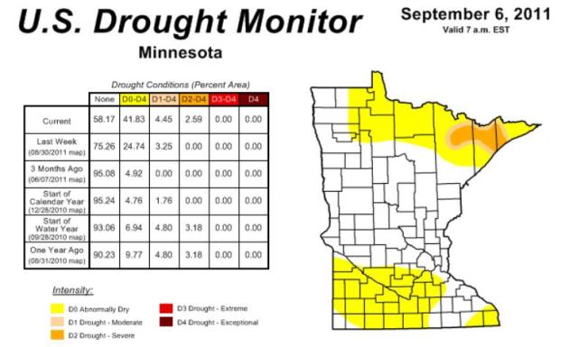
- The U. S. Drought Monitor released on September 1 depicts counties in both southern and northern Minnesota as "Abnormally Dry". Portions of St. Louis, Lake, and Cook counties are said to be experiencing "Moderate Drought". The Drought Monitor authors will likely present worsening drought conditions in both northern and southern Minnesota in their September 8 release.
* Click here for the latest Drought Monitor map, courtesy of NOAA.
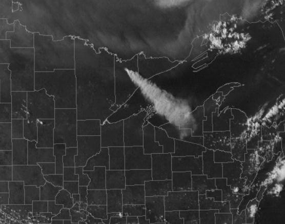
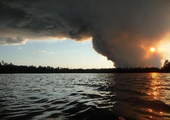
Boundary Waters Fire Doubles in Size. Here are more details from the Star Tribune: "ELY, Minn. - A forest fire in the Boundary Waters Canoe Area near Ely has more than doubled in size since Sunday. U.S. Forest Service spokeswoman Jean Bergerson said Monday the Pagami Creek fire has grown to 11,000 acres, from 4,500 acres on Sunday. Bergerson says about 70 hikers and canoeists have been moved from Lakes Two through Hudson and the Isabella River. Several waterways, entry points and portages in that area have been closed, including the popular Lake One and Isabella Lake entry points. Bergerson says a crew of 20 firefighters paddled into the fire area Sunday night. She says helicopters and small planes were used to dump water on the fire Sunday."
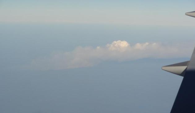
* I took the photo above from seat 24A on the Amsterdam to MSP Delta flight, which landed around 7 pm Sunday evening. You can just make out the dark gray of the smoke plume from the Pagami blaze below
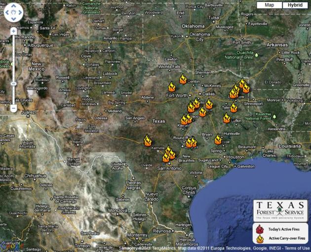
* click here for a map of the latest wildfires in Texas, courtesy of the Texas Interagency Coordination Center.
RECORD EVENT REPORT
NATIONAL WEATHER SERVICE EASTERN NORTH DAKOTA/GRAND FORKS
400 PM CDT TUE SEP 6 2011

...POTENTIAL MINNESOTA STATE RECORD PEAK WIND MEASUREMENT UNDER
REVIEW...

DURING THE EARLY MORNING HOURS OF SEPTEMBER 1ST 2011...A SEVERE
THUNDERSTORM PRODUCED DAMAGING WINDS ACROSS PORTIONS OF NORTHWESTERN
MINNESOTA. BETWEEN 303 AM AND 314 AM THE AUTOMATED ROADSIDE WEATHER
INFORMATION SYSTEM /RWIS/...NEAR DONALDSON MINNESOTA...RECORDED A
121 MPH PEAK WIND.
THE CURRENT STATE RECORD FOR MEASURED PEAK WIND AS RECOGNIZED BY THE
MINNESOTA STATE CLIMATOLOGIST WAS A 117 MPH GUST. THIS PEAK WIND
OCCURRED DURING A SEVERE THUNDERSTORM ON JULY 19 1983 NEAR
ALEXANDRIA MINNESOTA. HIGHER PEAK WIND ESTIMATES HAVE BEEN BEEN MADE
IN CONJUNCTION WITH DAMAGE FROM VARIOUS TORNADO EVENTS ACROSS THE
STATE.

THE 121 MPH PEAK WIND IS CURRENTLY UNDER REVIEW BY THE NWS AND THE
MINNESOTA STATE CLIMATOLOGIST OFFICE. SHOULD THIS BE VERIFIED...IT
WILL BE LISTED AS THE NEW OFFICIAL MINNESOTA STATE RECORD FOR A MEASURED

WIND SPEED. A FINAL DETERMINATION WILL BE MADE IN THE NEAR FUTURE. FOR
ADDITIONAL INFORMATION PLEASE CONTACT THE NWS IN GRAND FORKS.
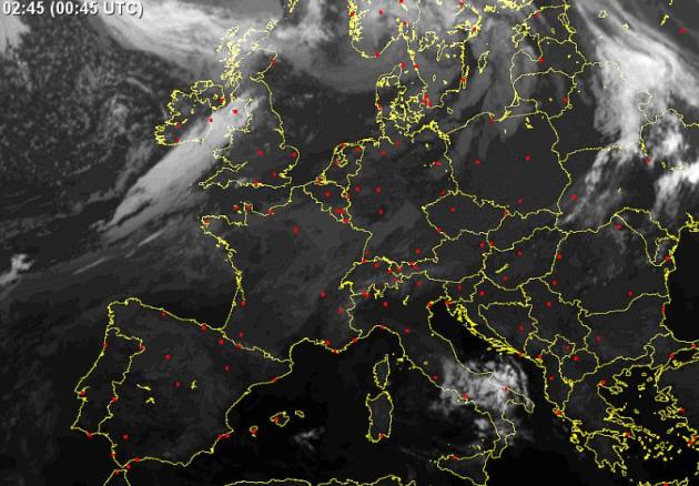
Severe Storms Batter Britain. The remains of Hurricane Katia are turbocharging the storm sweeping across the British Isles, according to Voice of America: "Britain is bracing for the most severe weather it has seen in 15 years as the remains of what was Hurricane Katia hit the country Monday. Britain's Met office has issued an “Amber Alert,” the second highest weather alert. Coastal areas could get hit with winds nearing 130 kilometers per hour, uprooting trees and causing flooding. The Met Office said the storm could impact parts of Northern Ireland, North Wales and Northern England, in addition to central and southern Scotland." (click here for a European satellite loop from sat24.com).

Futuristic Tornado-Proof Home Sinks Into The Ground At First Sign of Tornado. Well, that's practical, right? Good grief - kind of a cool concept, but probably not a scalable solution for millions of people living in tornado alley. Inhabitat.com has the details: "Had Dorothy lived in a home like this, she would have never met the Lion, the Tinman or the Scarecrow, but at least her house wouldn't have blown away and landed on a witch. Since it's unlikely we'll be able to completely avoid the dangers of tornados, our only remedy is to build in such a way as to reduce our risk from the damage of being in harm's way. Hong Kong-based 10 Design is working on a proposal for a tornado-proof house that easily belongs in the realm of a Star Trek movie. With the help of hydraulics, a high performance shell and solar power, the tornado-proof house retracts down into the ground at the first warning of an impending twister."
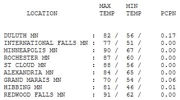
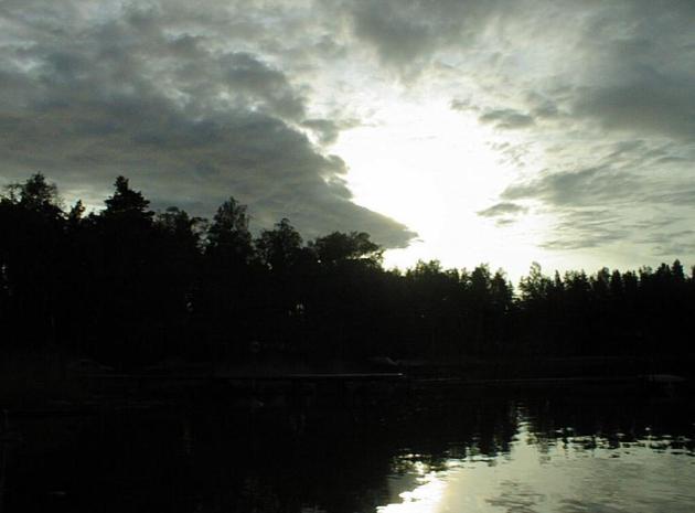
Last Hot Day In Sight. 90 in the Twin Cities, 91 at Redwood Falls, a balmy 88 at St. Cloud. We'll see more 80s before the flakes start to fly, possibly another 90 degree day or two, but not for the next week to 10 days.
Winter Whispers
"Unusual travel suggestions are dancing lessons from God," wrote Bill Bryson. Tell me about it. I just returned from a 1-week, 2,500 mile tour of Germany with my 81-year old father. We saw family, and I had plenty of opportunity to exercise my lead foot on the Autobahn (which has more orange construction cones than Minnesota highways!) Autumn has come early to much of Europe, and we'll get a taste of early October by midweek as the first significant cold front of the season arrives. 60s today, 50s tomorrow - frost up north by midweek? It's too early - ugh. No big storms are brewing, just more 70s early next week.
Lake levels are dropping after an unusually dry August. Parts of the MN Arrowhead are in a severe drought, so a long soaking would be welcome news right about now.
And NOAA is confirming a return of La Nina (cooling phase of the Pacific), which may lead to a colder, snowier than average winter for the USA's northern tier states. No El Nino to save us this winter. Odds are we'll see more snow than average (more than 55"), but I still doubt we'll come close to last winter's awe-inspiring 86.6".
Talk of snow is premature: we'll see more 70s and 80s before any flakes fly.
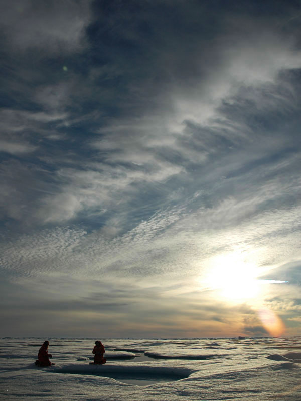
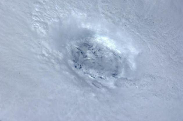
Arctic Ice Melts To Lowest Level On Record. The Sydney Morning Herald has the story: "LONDON: Ice at the North Pole has melted to the lowest level since satellite observations began in 1972, meaning the Arctic is almost certainly the smallest it has been for 8000 years, polar scientists said. If the trend continues, the Arctic will be largely ice-free in the northern summer 40 years earlier than anticipated in the last Intergovernmental Panel on Climate Change assessment report. Daily satellite sea ice maps released by Bremen University physicists show that with a week's further melt expected this year, the floating ice in the Arctic covered 4.24 million square kilometres on September 8. The previous one-day minimum was 4.27 million square kilometres on September 17, 2007. The National Snow and Ice Data Centre in the US is expected to announce similar results in a few days. The German researchers said the record melt was undoubtedly because of human-induced global warming. ''The sea ice retreat can no more be explained with the natural variability … caused by weather,'' the head of the Institute of Environmental Physics at Bremen, Georg Heygster, said." (photo above courtesy of NOAA).
Does Global Warming Portend An Ice-Free Arctic Summer? The story from the International Business Times: "Reports about an Arctic summertime sans ice due to global warming and natural swings in regional wind patterns are quite alarming. The extent of summer sea ice in the Arctic Ocean reached a record low this week since satellite observations began in 1972, according to the University of Bremen's Institute of Environmental Physics. The area covered by the Arctic sea ice shrank to 4.24 million square kilometers (1.637 square miles) on Sept. 8, said researchers from the University. The historic low measurement is about a half-percent below the previous record low set in Sept. 16, 2007, said Georg Heygster, head of the Physical Analysis of Remote Sensing Images unit at the University of Bremen's Institute of Environmental Physics. The record set on that day was 4.27m sq km, reports the Guardian. The declining Arctic sea ice has also become significantly thinner in recent decades, though it is not possible to measure the shrinkage in thickness as precisely as for surface area, said the institute."
No comments:
Post a Comment