36 F. record low for Thursday morning in the Twin Cities (set most recently in 2007).
...EARLY SEASON FREEZE FOR MUCH OF THE AREA TONIGHT...

.A FREEZE WARNING REMAINS IN EFFECT FOR ALL OF CENTRAL AND
SOUTHERN MINNESOTA AND WEST CENTRAL WISCONSIN FROM MIDNIGHT
TONIGHT THROUGH 8 AM THURSDAY MORNING.

STRONG CANADIAN HIGH PRESSURE WILL SETTLE OVER THE AREA TONIGHT...
BRINGING A COMBINATION OF LIGHT WIND...A CLEAR SKY...AND WELL
BELOW NORMAL TEMPERATURES. A WIDESPREAD FREEZE APPEARS LIKELY
WITH LOW TEMPERATURES IN MOST LOCATIONS BETWEEN 25 AND
30 DEGREES. TEMPERATURES WILL DROP INTO THE MID 30S IN MOST
LOCATIONS BY AROUND MIDNIGHT...THEN SUB FREEZING TEMPERATURES WILL
BECOME LIKELY AFTER 2 AM.

SENSITIVE OUTDOOR PLANTS WILL BE IMPACTED TONIGHT IF LEFT
UNCOVERED.
36 F. or colder on September 15 in the Twin Cities? A "1 in 10 year event", according to Pete Boulay at the State Climate Office.
Saturday night:
best chance of weekend showers. A few showers may spill over into Sunday morning.
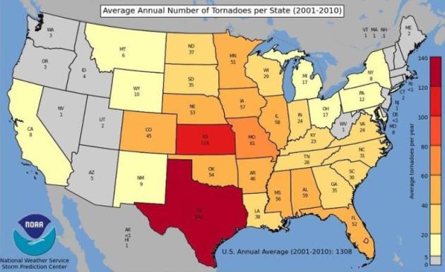
51: average number of tornadoes every year in Minnesota since 2001.
1918: last year Minnesota saw a larger wildfire than the current BWCA Pagami blaze.
70 days above 100 in Dallas/Fort Worth this summer (a new, all-time record). Old record was 69 days over 100 in 1980
40 of those 100-degree days were in a row in Dallas.
2-6" of snow possible near Vail, Aspen and Breckenridge, Colorado - heaviest amounts above 9,000 feet.
"...
Climate is central to business strategy of 68% of the world's 500 largest companies, compared with 48% last year." - from an article in The Guardian below.
"...
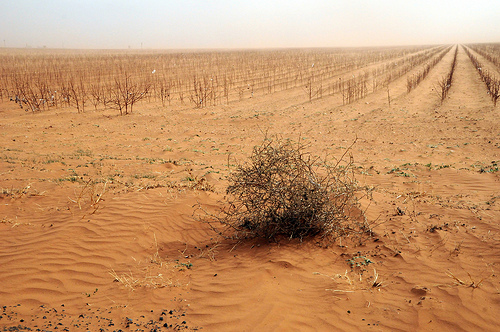
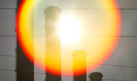
And the changing Texas climate is not an isolated phenomenon. Extreme climatic events are becoming the order of the day around the world. For examples, most of North America has been experiencing more unusually hot days and nights, fewer unusually cold days and nights, and fewer frost days. Heavy downpours have become more frequent and intense. Droughts are becoming more severe in some regions, though there are no clear patterns for the globe as a whole. The power and frequency of Atlantic hurricanes have increased substantially. Outside the tropics, storm tracks are shifting northward and the strongest storms are becoming even stronger." - Houston Chronicle story below. Photo credit:
myweathertech.com.
 Wednesday Record Highs:
San Antonio, TX: 99
Austin Bergstrom: 101
Lufkin: 102
Austin Camp Mabry: 103
College Station: 101
Houston: 99
******Dallas only hit 94 Wednesday*******
Cape Hatteras, NC: 87
Bridgeport, CT: 86
Shreveport, LA: 102
Weather Slows The Spread Of BWCA Fire. Winds have eased (slightly), cooler temperatures helping firefighter efforts. Here's an update from the
Star Tribune on what is thought to be Minnesota's largest wildfire since 1918: "
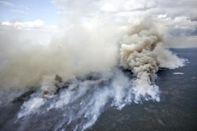
Most of the wilderness area is shut down. Fanned by unanticipated winds and fueled by dry wood, the blaze has spread rapidly to consume more than 100,000 acres, making it one of the biggest forest fires in Minnesota history. A massive, unpredictable fire that sent ash plumes hundreds of miles forced authorities Tuesday to shut down most of the Boundary Waters Canoe Area Wilderness and urge hundreds of nearby homeowners to flee. Fanned by unanticipated winds and fueled by dry wood, the blaze has spread rapidly to consume more than 100,000 acres, making it one of the biggest forest fires in Minnesota history. One U.S. Forest Service official called the speed of the fire "pretty much unprecedented." Defying firefighters' efforts to contain it to the wilderness area, the blaze broke through the southern edge of the BWCA in northeastern Minnesota to threaten private property. Firefighters also were closely watching the eastern edge of the fire, which reached a small portion of the forest knocked down by a major windstorm in 1999. The blowdown left miles of dry timber in its path. "Already severe and erratic fire behavior ... is going to be more severe and more erratic if it's in the blowdown," said Jean Bergerson, lead public information officer for the Forest Service and state and local agencies fighting the fire. "It's going to be an additional cause for concern."
Photo credit above: "The Pagami Creek wildfire burns in the Boundary Waters Canoe Area Wilderness in Northeastern Minnesota. The haze from the fire was heavy enough that some people reported burning eyes and difficulty breathing in the Chicago area, 400 miles south of the forest fire, the National Weather Service said.
Clint Austin -- Duluth News Tribune, Associated Press - AP
- At this point the Pagami blaze covers approximately 10 percent of the vast Boundary Waters Canoe Area.
- Exceeds 101,000 acres.
- 230 personnel helping to fight the flames.
- The fire pushed farther south yesterday exiting the southern Boundary Waters Canoe Area
- Homes are being evacuated.
- So far 100,000 acres have burned. Started by lightning August 18.
- The Milwaukee Brewers closed the Miller Park roof before their game against the Colorado Rockies due to the lingering smoke from a wildfire burning in Minnesota.
- Largest wildfire in Minnesota since 1918.
- The Pagami Creek fire is ranked as the third largest fire in the history of Minnesota. Larger fires were the 250,000-acre fire near Cloquet in October of 1918 which killed 559 people, and a 200,000-acre fire near Hinckley in September of 1894 which killed 418 people.
- Officials are saying that the blaze will probably burn until the snow flies.
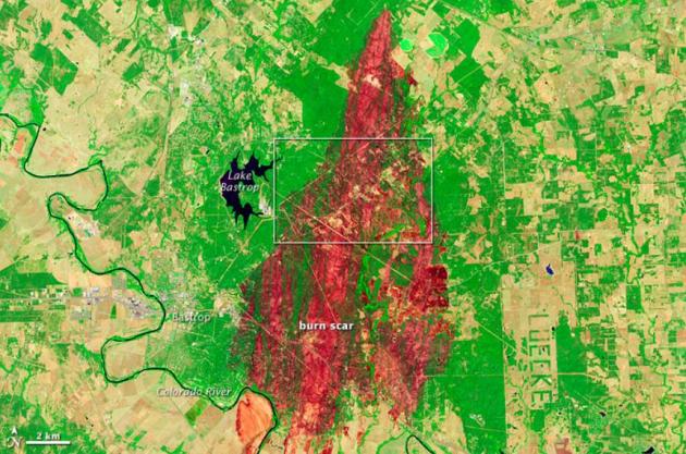
Bastrop, Texas Fire From Space. Here's an update from NASA's
Earth Observatory: "
The Bastrop County Complex Fire in southern Texas started on September 4, 2011. By September 13, the fire was 70 percent contained, but had scorched 34,068 acres (13,787 hectares). The Advanced Land Imager (ALI) on NASA’s Earth Observing-1 (EO-1) satellite captured these images of the region on September 12, 2011. The false-color image (top) shows a wide-area view of the fire. Vegetation is bright green, and sparsely vegetated or bare land is green-yellow. The burn scar appears in shades of red and orange. Far from uniform, the burned areas are separated by unburned expanses. The area outlined in white in the top image corresponds to the close-up view provided in the natural-color image (bottom). Land in and around the Circle D-KC Estates is charred to shades of brown and gray."
From Mega-blizzards to Earthquakes to Hurricanes: New Jersey Has Seen A Year Of Wild Weather. It's been an historic year for New Jersey, and many other states east of the Rockies. Here's a story from
NJ.com: "
Time makes weather the stuff of legend. As the years go by, the snow drifts from blizzards inch higher and higher. The marks on homes and businesses where the flood waters reached crawl further up the walls as the story of the great flood is told again and again. You could fry an egg on the sidewalk that one unbearably hot day in five minutes. Four. Two. But it seems, as New Jersey gets pummeled with one historic weather event after another, the last nine months won’t need the help of exaggeration. The story itself is beyond what the imagination could conjure. "It’s breathtaking," said Henry Margusity, a severe weather expert with Accuweather . "The New York City (metropolitan area) has had one of every major weather event so far this year. Flooding, a blizzard, high wind events, tornadoes and hail. Even an earthquake. What else can you have? That’s unbelievable to me." He added "I’ve never seen this before in my life."
Lessons Learned From Hurricane Irene Can Help You Prepare For Future Disasters. Some sound advice from prnewswire.com: "
Hurricane Irene, with its high wind, torrential rain and flooding, was a wake-up call for the residents of many states up and down the East Coast of the United States, providing important lessons to millions of Americans on how to prepare for future storms, according to the Insurance Information Institute (I.I.I.). "Those who take the time to prepare for a disaster are in the best position to survive a catastrophe and recover as quickly as possible," pointed out Jeanne M. Salvatore, senior vice president and consumer spokesperson for the I.I.I. Hurricane season, which ends on November 30, is far from over so it is still possible for another storm to make landfall in the U.S. In fact, six of the ten most expensive hurricanes in the U.S. occurred in September and one in late October. Damage caused by wind is one of the most consistent and major causes of property loss. Hurricanes and tropical storms accounted for 44 percent of all catastrophe losses over the 20-year period from 1991 to 2010. Tornadoes, which frequently accompany hurricanes, ranked second highest, representing 30 percent of catastrophe losses for the period. Hurricane Irene provided a stark reminder that the entire East Coast is at risk for catastrophic storms. While Florida and the Gulf coast may have more frequent hurricanes, the Northeast also has a history of severe storms. The Great New England Hurricane of 1938 (also known as "The Long Island Express") hit New York, Connecticut, Rhode Island and Massachusetts, causing 600 deaths, 1,700 injuries and over $400 million in damages, according to the Massachusetts Executive Office of Public Safety and Security (EOPSS). AIR Worldwide estimates that the storm would have caused $38 billion in insurance damages had it occurred today."
Is The Atlantic Hurricane Season Winding Down? The jet stream, the prevailing belt of westerlies, is pushing south, in a pattern that resembles late September and early October. That may nudge any tropical systems out into the Atlantic in the coming weeks. America may just dodge a bullet, according to the Washington Post's
Capital Weather Gang: "
The Atlantic hurricane season is not over by a long shot. In fact, we’re in the middle of the most active few weeks of the season historically. However, the tropics seem poised to enter a temporary quiet period once tropical storm Maria becomes part of an extratropical rainstorm over the North Atlantic in a couple days. A spell of inhospitable conditions that will shut down storm development is beginning to temporarily settle over Africa and the Atlantic Basin. To date, this season has produced a lot of hype and very few hurricanes. In all, we’ve seen one tropical depression, 12 tropical storms, and two hurricanes. Though the total storm count is atypically high, only Irene made a North American landfall at hurricane strength - and did so just barely along a small section of North Carolina’s Outer Banks. All other members of the 2011 class so far either made landfall at tropical storm strength or curved out to sea a long way from our shores. During the next week or so, mechanisms that partly govern the dryness, wind shear, and vertical stability (i.e., resistance to thunderstorm development) over the tropics will conspire to suppress the likelihood of tropical cyclone genesis in the Atlantic Basin. The image below offers a simplistic overview of what’s currently going on."
Average Number of Tornadoes Since 2001. For the last 30 years I've been telling Minnesotans that the average number of tornadoes every summer season is around 25, give or take. Now comes word (from SPC) that the average from 2001 - 2010 was 51 in Minnesota. That number is being biased by 2010's incredible 145 tornado count in Minnesota (most in the nation). Map courtesy of SPC,
Twitter and EverythingWX.
Double Jeopardy: Building Codes May Underestimate Risks Due To Multiple Hazards. Here's an interesting story from
physorg.com: "
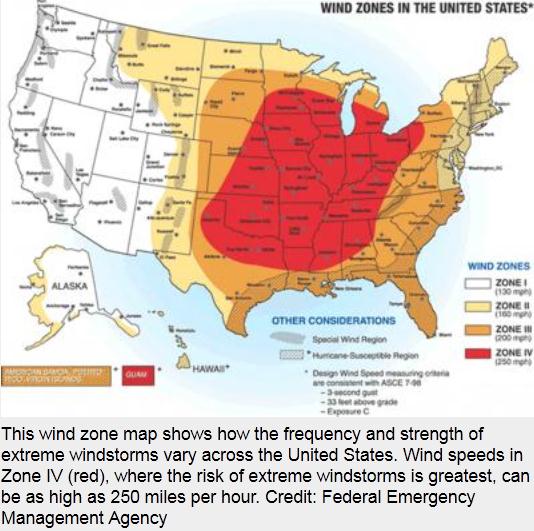
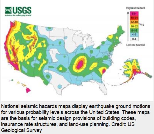
As large parts of the nation recover from nature's one-two punch—an earthquake followed by Hurricane Irene—building researchers from the National Institute of Standards and Technology warn that a double whammy of seismic and wind hazards can increase the risk of structural damage to as much as twice the level implied in building codes. This is because current codes consider natural hazards individually, explains NIST's Dat Duthinh, a research structural engineer. So, if earthquakes rank as the top threat in a particular area, local codes require buildings to withstand a specified seismic load. In contrast, if hurricanes or tornadoes are the chief hazard, homes and buildings must be designed to resist loads up to an established maximum wind speed. In a timely article published in the Journal of Structural Engineering,* Duthinh, NIST Fellow Emil Simiu and Chiara Crosti (now at the University of Rome) challenge this compartmentalized approach. They show that in areas prone to both seismic and wind hazards, such as South Carolina, the risk that design limits will be exceeded can be as much as twice the risk in regions where only one hazard occurs, even accounting for the fact that these multiple hazards almost never occur simultaneously."
Seismic Risk. Well, at least there's one natural disaster Minnesotans don't have to worry about.
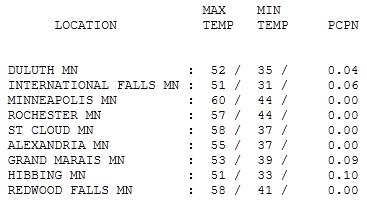 Hints of Early October
. At least the sun was out much of the day, removing some of the cool sting behind a vigorous cold front. Highs ranged from 51 at International Falls and Hibbing to 58 in St. Cloud and Redwood Falls to 60 in the Twin Cities. About a tenth of an inch of showery rains fell on the MN Arrowhead, helping firefighters gain some ground on the Pagami blaze.
 Paul's Conservation Minnesota Outlook for the Twin Cities and all of Minnesota:
TODAY: Frosty 'burbs early. Bright sun, less wind. Winds: SE 3-8. High: 58
THURSDAY NIGHT: Clear, not quite as chilly. Low: 40
FRIDAY: Plenty of sun, milder. High: 61
SATURDAY: Sunny start, increasing PM clouds - probably the nicer day of the weekend. Low: 48. High: 63
SUNDAY: Patchy clouds, a few passing showers. Low: 53. High: 69
MONDAY: Drier and milder, isolated PM T-shower? Low: 57. High: 74
TUESDAY: Milder, showers and T-storms likely. Low: 59. High: 78
WEDNESDAY: Unsettled, few more showers. Low: 57. High: 72
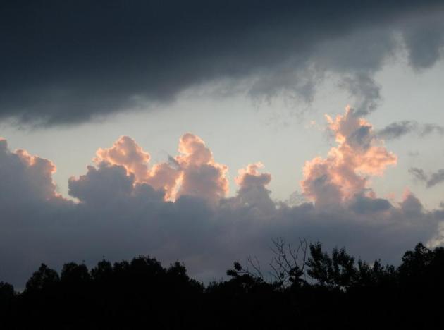
Rare Mid-September Frost
It's early to be tracking frost and freezing temperatures. According to Pete Boulay at the State Climate Office a 36 degree low at MSP on September 15 is a "1 in 10 year event". This fleeting cold blip does not mean a harsh winter is inevitable, or "Winter will come early this year." The reality: we'll see more 70s, probably a few more 80s in late September and early October. Don't pack away the summer wardrobe just yet.
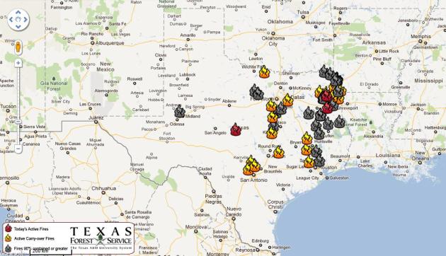
Some will confuse weather and climate, point to frost in mid September as another reason to ignore climate scientists. This, in spite of arctic ice reaching a new all-time minimum this week, 2010 as the warmest year worldwide, 1-in-1000-year floods in Virginia, and an increase in weather extremes worldwide. Dallas has endured a record 71 days above 100; Texas fires scorching an area the size of Connecticut. Avoid looking out the window to get your climate science; keeping a global perspective is tough, but necessary.
Bright sun means upper 50s today, near 60 Friday. Saturday is the nicer day of the weekend, a few showers arriving Sunday. 70s return next week, models hinting at 80 the weekend of September 24-25.
No, winter is NOT right around the corner!
Texas Wildfires: More Evidence Of Climate Change. Here's an update from the Baker Institute Blog, part of the
Houston Chronicle: "
Six of the 10 largest wildfires in Texas history occurred in 2011. This year’s wildfire in Bastrop County set a somber state record for destruction: the highest number of homes lost in a single fire in Texas history. Although it’s too soon to determine the total amount of insured property losses caused by Texas wildfires, 2011 is projected to be the worst in state history according to a spokesperson of the Insurance Council of Texas. The cost may exceed $150 million. The previous cost record was set in 2009, when fires caused more than $100 million in insured property damages statewide. In fact, Texas is currently dealing with its third yearlong wildfire season since 2005 — and its most severe. Others were in 2008 and 2009. No one can dispute that the Texas wildfire epidemic of the past six years, culminating in the most severe this year, is very closely related to the extreme heat and drought that have been plaguing Texas. And the changing Texas climate is not an isolated phenomenon. Extreme climatic events are becoming the order of the day around the world. For examples, most of North America has been experiencing more unusually hot days and nights, fewer unusually cold days and nights, and fewer frost days. Heavy downpours have become more frequent and intense. Droughts are becoming more severe in some regions, though there are no clear patterns for the globe as a whole. The power and frequency of Atlantic hurricanes have increased substantially. Outside the tropics, storm tracks are shifting northward and the strongest storms are becoming even stronger."
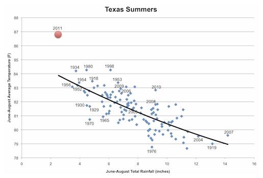
Global Warming Amplifying Texas Drought And Wildfires. Check out where the summer of 2011 stands in Dallas weather records, literally off the scale (far upper left part of graph). 2011 was the hottest and the driest year on record. Another fluke, or did climate change contribute to the severity and duration of the drought, heat and wildfires gripping Texas? Here's a story from
onearth.org: "
Just when it looked like weather conditions couldn’t get any worse in Texas, a new wildfire burning outside of Austin destroyed nearly 800 homes last week. This came on the heels of the state's hottest and driest summer in recorded history, with many parts of the state smashing all-time records by wide margins. Last week, Texas state climatologist John Nielsen-Gammon announced this was the hottest summer on record for Texas -- and the hottest summer ever for any U.S. state, based on preliminary numbers -- and last month he declared Texas is in the midst of its worst one-year drought on record. The blend of hot weather and parched land has made for perfect fire conditions, and this has been the worst year for Texas wildfires in over a decade. Nearly 3.6 million acres of the "Lone Star State" have burned so far this year, an area roughly the size of Connecticut. The heat and drought are record-breaking, but how unusual are they? According to Nielsen-Gammon’s own blog, it’s in a category unto itself: "The year 2011 continues the recent trend of being much warmer than the historical precipitation-temperature relationship would indicate, although with no previous points so dry it’s hard to say exactly what history would say about a summer such as this one. Except that this summer is way beyond the previous envelope of summer temperature and precipitation," Nielson-Gammon wrote."
Is It Weird Enough Yet? Thomas Friedman takes a look at recent weather trends around the globe, the "global weirding" taking place before our eyes. Here's an excerpt from his
New York Times Op-Ed: "
Remember the first rule of global warming. The way it unfolds is really “global weirding.” The weather gets weird: the hots get hotter; the wets wetter; and the dries get drier. This is not a hoax. This is high school physics, as Katharine Hayhoe, a climatologist in Texas, explained on Joe Romm’s invaluable Climateprogress.org blog: “As our atmosphere becomes warmer, it can hold more water vapor. Atmospheric circulation patterns shift, bringing more rain to some places and less to others. For example, when a storm comes, in many cases there is more water available in the atmosphere and rainfall is heavier. When a drought comes, often temperatures are already higher than they would have been 50 years ago, and so the effects of the drought are magnified by higher evaporation rates.” CNN reported on Sept. 9 that “Texas had the distinction of experiencing the warmest summer on record of any state in America, with an average of 86.8 degrees. Dallas residents sweltered for 40 consecutive days of grueling 100-plus degree temperatures. ... Temperature-related energy demands soared more than 22 percent above the norm this summer, the largest increase since record-keeping of energy demands began more than a century ago.”
World's Largest Firms "Acting On Climate Change", Analysis Shows. Here's a surprising story from
The Guardian: "
A majority of the world's largest firms are taking action on climate change as part of their business strategy for the first time, a survey has found. The 10th annual Carbon Disclosure Project, which analysed responses from 396 of the 500 largest companies in the world, found more than two-thirds (68%) now say they put climate change central to their business, compared with 48% last year. Almost half (45%) are now reporting they have cut their greenhouse gas emissions as a result of steps they have taken to tackle carbon, up from less than a fifth (19%) in 2010. The Carbon Disclosure Project report, written by PwC, also said there was a link between higher stock market performance and action on climate change, with those that have a strong focus on the issue providing investors with approximately double the average return over the period 2005 to 2011."
GOP's Huntsman A Voice Of Reason On Global Warming. Here's an Op-Ed from the
Arizona Daily Star and L.A. Times: "
Not all Republicans are stuck in the Middle Ages when it comes to attitudes about science. At the party's presidential debate Wednesday night in Simi Valley, Jon Huntsman Jr. showed that at least some of the candidates have advanced past the Enlightenment era. "Listen, when you make comments that fly in the face of what 98 out of 100 climate scientists have said, when you call into question the science of evolution, all I'm saying is that, in order for the Republican Party to win, we can't run from science," Huntsman said. The former Utah governor might have only the slimmest of chances to win the GOP nomination, but he isn't the only candidate to acknowledge the scientific consensus that the climate is changing and that the greenhouse gases produced by human activity are the cause; former Massachusetts Gov. Mitt Romney also recognizes the problem and the need to do something about it, though he hasn't been specific about solutions and has condemned such proposals as carbon taxes or a cap-and-trade program. On the other side, though, is the rest of the Republican field, led by Texas Gov. Rick Perry, who has referred to climate change theory as a "contrived phony mess" and whose defense of this position Wednesday night marked the intellectual nadir of the debate. "Well, I do agree that there is - the science is not settled on this," Perry said. "The idea that we would put Americans' economy at jeopardy based on scientific theory that's not settled yet, to me, is just nonsense." Perry went on to compare himself, or those who agree with him, to 17th century astronomer Galileo Galilei, who in Perry's words also "got outvoted for a spell" when he adopted a minority opinion on a scientific issue."
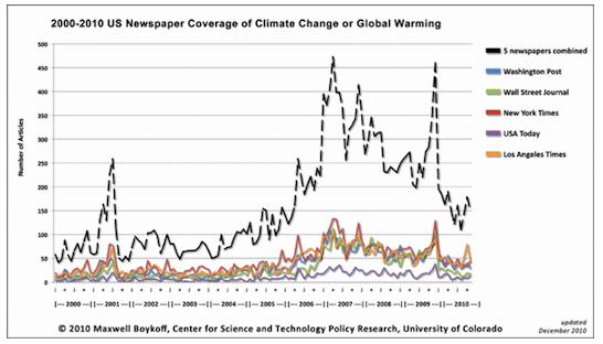
Media Coverage Of Climate Change "Fell Off The Map" In 2010. Joe Romm has the story at
thinkprogress.org: "
We had jaw-dropping science in 2010 (A stunning year in climate science reveals that human civilization is on the precipice). We had gripping climatic disasters (Masters: “The stunning extremes we witnessed gives me concern that our climate is showing the early signs of instability”; Munich Re: “The only plausible explanation for the rise in weather-related catastrophes is climate change”). And we even had major political theater — domestic (The failed presidency of Barack Obama, Part 1 and Part 2) and international (see The Cancun Compromise). But, as we’ll see, the one-time paper of record didn’t have climate change in a single one of its largest lead headlines. And analyses of multiple databases reveal that the rest of the media sheepishly returned to 2005 levels of coverage. The Daily Climate’s Douglas Fischer reports: Media coverage of climate change in 2010 slipped to levels not seen since 2005, after spiking in in late 2009 in the run-up to the much-hyped United Nations climate talks in Copenhagen and the release of private emails from climate scientists stored on a English university server.. Analysis of DailyClimate.org’s archive of global media coverage shows that journalists published 23,156 climate-related stories in English last year — a 30 percent drop from ’09′s tally. Those stories came from 8,710 different reporters, columnists and editorial writers at 1,552 different media outlets. Last year, according to the Web site’s database, more than 11,000 reporters tackled the subject – a 22 percent drop for 2010."
Can We Blame Global Warming For Hurricane Irene? Here's an Op-Ed in the
Alaska Dispatch: "
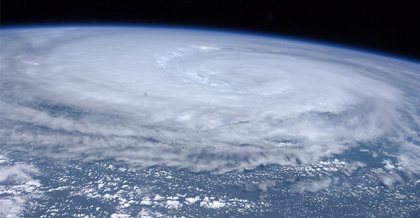
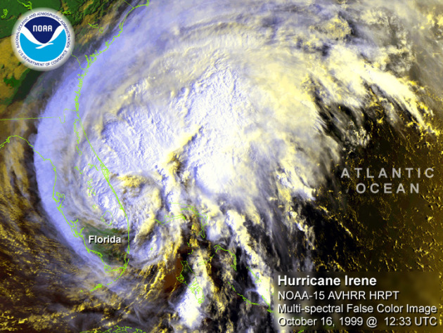
Like many people, I spent the last weekend in August mesmerized by the steady progress of hurricane Irene as she followed the script so carefully laid out by the National Weather Service’s Hurricane Tracking Center. Not too long ago, hurricane prediction was more like trying to guess the direction that an improvisational theatrical performance was going to take. However, as the science has improved, some of the apparent spontaneity of hurricanes has disappeared. Nevertheless, there remain questions that scientists cannot and never will be able to answer with certainty. One of these unanswerable questions, literally a billion-dollar question, is the following: Is global climate change responsible for a given hurricane or any other weather disaster? Scientific answers to this question can be either simple or complex. The simple answer is that we cannot know with absolute certainty that global climate change caused any particular weather event. However, the science is improving to the point that we can begin to start assigning probabilities to such events as the Earth’s climate warms in response to humanity’s continuing emissions of greenhouse gases. For example, in the case of Irene, we cannot say that global climate change bears any responsibility for the havoc wrought by this particular hurricane. On the other hand, we do have the knowledge and scientific tools to predict how greenhouse warming will increase the likelihood of future hurricanes exhibiting Irene’s magnitude and track along the eastern seaboard of the United States. We know for instance that the warm oceanic waters of the tropics serve as the heat engine for hurricane development. Therefore, as these oceanic waters are warmed further, a greater number of intense hurricanes like Irene will make landfall in North Carolina." (photo above courtesy of NOAA).









No comments:
Post a Comment