36 F. low Thursday morning in the Twin Cities (tied a record).
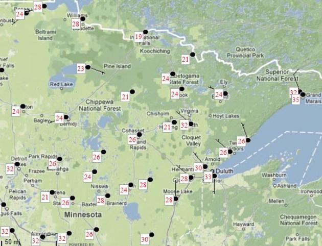
19 F. at Embarrass and International Falls Thursday morning.
Trace of flurries Wednesday in Duluth, tied a record.
78 F. Thursday's high at DFW Airport.
That's the coolest high temperature in Dallas since May 16, when the high was 74.
88% of Texas now in "exceptional drought", the most severe conditions - highest of the year. Up from 81% a week ago.
2.83" of rain fell on Tucson, AZ Thursday, This is a RECORD for the day, 2nd wettest Sept. day on RECORD and 5th wettest day of all time.
"
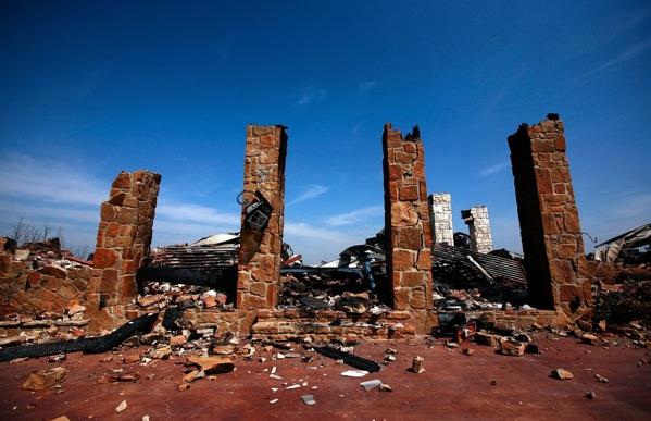
...There’s no denying the weather has become more extreme. Years of drought in Australia have been followed by devastating floods. Weather events causing more than $10 billion in damage, from floods and wildfires to an East Coast snopocalypse, have hit the United States this year. In Pakistan, large swaths of land sit under floodwaters. Munich Re, the large reinsurance company, has estimated that natural disasters caused $265 billion in damage in the first six months of the year, five times more than the average losses for that period over the last decade." - from a New York Times article below.
"...
The world has entered a new era of catastrophes. Economic losses from hurricanes, earthquakes and resulting tsunamis, floods, wildfires and other natural disasters increased from $528 billion (1981-1990) to more than $1.2 trillion over the period 2001-2010." - from a Washington Post story below.
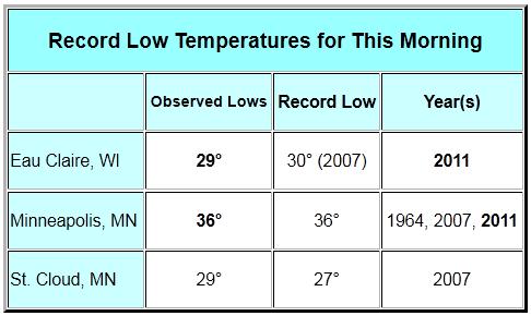
Thursday Record Lows:
Pierre, SD: 32
Sisseton, SD: 30
Lincoln, IL: 37
Mason City, IA: 26
Flint, MI: 38
International Falls, MN: 19
Rochester, MN: 31
Milwaukee, WI: 40
Sioux City, IA: 32
Rolla-Vichy, MO: 41
Twin Cities, MN: 36
Eau Claire, WI: 29
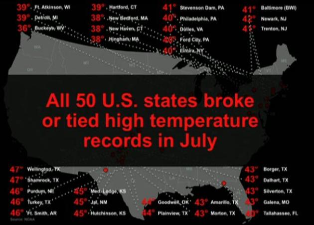
Thursday Record Highs:
Beaumont Port Arthur, LA: 96
TIDBITS......
*****North Platte, NE only reached a high of 47 today!!!
****record early snow (just a trace) for Duluth & the Lakewoods of WI
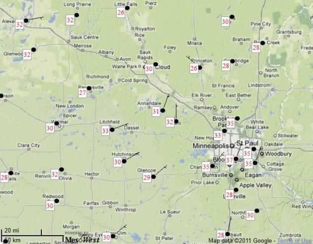
Metro Lows Thursday Morning. As expected, the close-in suburbs pretty much avoided frost yesterday, thanks to the "urban heat island" - more development, asphalt and concrete retaining heat. Lakeville reported 28, 26 up north in Princeton.
Up North Lows Thursday Morning. 19 F. reported at International Falls and Embarrass, 30 in downtown Duluth, 28 at Braiinerd and 24 at Nisswa.
First Frost. The urban heat island prevented a frost in the immediate Twin Cities, but sub-freezing temperatures were reported from Rice Lake, Wisconsin to Red Wing, New Ulm, Morris, Albert Lea and Benson....coming a good 2 weeks ahead of schedule for many Minnesota towns.
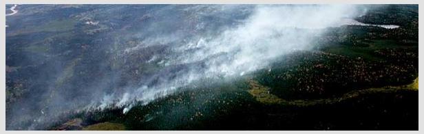
Additional Firefighters Join Attack On BWCA Wildfire. The
Brainerd Dispatch has the story: "
ISABELLA, Minn. (AP) — The attack on a large wildfire burning near the Minnesota-Canada border was expected to strengthen Thursday when 100 additional firefighters join crews on the ground in the Boundary Waters Canoe Area Wilderness. The added help brings the number of firefighters in northern Minnesota to more than 400, according to the U.S. Forest Service. After overnight temperatures dropped below freezing, a light snowfall and calm winds, the wildfire that has spread to nearly 160 square miles of forest land does not appear to have expanded significantly since Wednesday, said Forest Service spokeswoman Lisa Radosevich-Craig. Firefighters will attack the fire in the northwest corner of the Boundary Waters, where it began with a lightning strike Aug. 18 and will also work on the southern edge of the wilderness, she said."
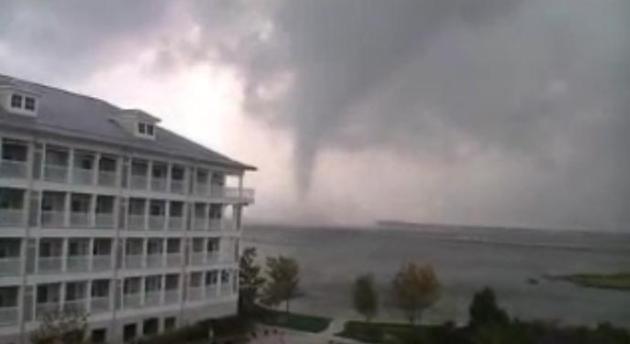 Ocean City, Maryland Waterspout
. Check out the
YouTube clip of the waterspout (tornado over water) that formed at 3:43 pm yesterday.
Prepare Yourself, Natural Disasters Will Only Get Worse. Here's an excerpt of a story in the
Washington Post: "
The world has entered a new era of catastrophes. Economic losses from hurricanes, earthquakes and resulting tsunamis, floods, wildfires and other natural disasters increased from $528 billion (1981-1990) to more than $1.2 trillion over the period 2001-2010. The 9.0 earthquake and massive tsunami in Japan this past spring caused hundreds of billions of dollars of direct and indirect costs. It has affected the Japanese macroeconomic forecast and resulted in the departure of the then-prime minister. And before this, massive earthquakes in Haiti, Chile and New Zealand inflicted record human and financial losses as well. Despite being the richest country in the world, America is still highly vulnerable to natural disasters. Two principal socioeconomic factors directly influence the level of economic losses due to catastrophic events: exposed population and value at risk. Florida, for example, has seen its population grow from 2.8 million inhabitants in 1950 to 18.8 million in 2010 (+570%). Increased population and development means an increased likelihood of severe economic and insured losses in Florida and other hurricane-prone regions unless cost-effective mitigation measures are implemented and the risk properly hedged."
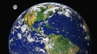
NOAA: Globe had eighth warmest August on record
The globe had its eighth warmest August since record keeping began in 1880, while June through August was the seventh warmest such period on record. The Arctic sea ice extent was the second smallest for August on record at 28 percent below average.
This monthly analysis from NOAA’s National Climatic Data Center is part of the suite of climate services NOAA provides government, business and community leaders so they can make informed decisions.
Global Temperature Highlights: August
- The combined global land and ocean average surface temperature for August 2011 was the eighth warmest on record at 61.09 F (16.15 C), which is 0.99 F (0.55 C) above the 20th century average of 60.1 F (15.6 C). The margin of error associated with this temperature is +/- 0.16 F (0.09 C).
- Separately, the global land surface temperature was 1.51 F (0.84 C) above the 20th century average of 56.9 F (13.8 C), making this the second warmest August on record. The margin of error is +/- 0.32 F (0.18 C). Warmer-than-average conditions occurred across most of North America and the northern half of South America, southern Greenland, eastern Russia, Mongolia, most of Europe, northern Africa to Southwest Asia, and southern Australia. Cooler-than-average regions included western Russia, Alaska, Chile, Argentina, and Uruguay.
- The August global ocean surface temperature was 0.79 F (0.44 C) above the 20th century average of 61.4 F (16.4 C), making it the 12th warmest August on record. The margin of error is +/- 0.07 F (0.04 C). The warmth was most pronounced across the north central, northwest, and south central Pacific Ocean, the north-central Atlantic, and the Labrador Sea.
- Scotland and Northern Ireland had their coolest average monthly August temperatures since 1993. Scotland was 1.4 F (0.7 C) below its 1971–2000 average of 55.2 F (12.9 C), while Northern Ireland was 1.3 F (0.8 C) below its average temperature of 57.6 F (14.2 C).
- Australia’s August 2011 average maximum temperature was the fifth warmest August in its 62-year period of record. The state of Tasmania had its all-time warmest August maximum and minimum temperatures on record.
Here's an intriguing story from the
New York Times about lightning frequency/intensity as a leading indicator for hurricane intensification or weakening: "
Radar and satellites can track the path of storms, but Earth Networks, a company that operates networks of environmental sensors, says it can predict their intensity. The company has come up with a system that detects and geographically pinpoints electrical activity, that is, lightning, in storms. It then runs this information along with other meteorological data on temperature, pressure and wind speed through supercomputers to predict whether a storm will peter out as it hits land or wreak even greater havoc. “We measure every spark in the cloud,” says the company’s chief executive, Bob Marshall. “Radar is great at forecasting the track of a storm, but intensity is more of a mystery. Predicting intensity is not much better than it was a decade or two ago.” The company has already installed about 360 lightning sensors. Most are in the United States and function as part of its 8,000-node domestic weather network. Soon, Earth Networks plans to set up a lightning network in Brazil, where storm tracking is already hampered by spotty satellite and radar coverage. The company has also had discussions with Indian aviation officials."
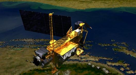
NASA Satellite Set To Crash Back To Earth. What's that George Carlin line? "Don't sweat the showers".
Gizmag.com has the details: "
NASA has recently announced that an out-of-control, retired satellite will come crashing into the earth's surface "sometime" towards the end of September. Furthermore, the satellite, which is about the size of a school bus and weights over 6 tonnes (6.6 tons), will impact the earth in an unknown location between Canada and South America. The exact time and location will remain a mystery until two hours before the event, and that's with six thousand miles (10,000 km) of uncertainty. "It is too early to say exactly when UARS will re-enter and what geographic area may be affected," states NASA. The Upper Atmosphere Research Satellite (UARS) will come crashing back to Earth after it was placed into orbit almost twenty years ago. Although the spacecraft will break into pieces during re-entry, not all of it will burn up in the atmosphere beforehand. It is anticipated that 26 large fragments of the UARS satellite will actually fall to Earth, in a rain of debris altogether weighing about 1,170 pounds/532 kg (the largest weighing 300 pounds/150 kg). Though it is impossible to predict the exact impact zones, NASA estimates the debris footprint will be approximately 500 miles (800 km) long."
Webcam 101 For Seniors Turns Oregon Oldsters Into YouTube Celebrities. If you've ever tried to have a (video) Skype call with your parents or grandparents you'll really get a kick out of this video clip, courtesy of the
Huffington Post: "
A couple from northwestern Oregon who are Internet newbies have found themselves the unwitting subjects of an instant viral video, thanks to a little help from a grandkid. Bruce Huffman, 86, and his wife, Esther, 79, of the Hillside Retirement Community in McMinnville, recently purchased their first laptop computer –- an aqua colored beauty with a built-in webcam. Late last month, the couple sat down together and tried to figure out how to make a video with the webcam, something a granddaughter had painstakingly attempted to teach Esther a few days beforehand. "I was trying to figure out how to do the videos and didn't know the thing was actually running," Esther told The Huffington Post. "All the while, Bruce was kind of amusing himself because he was bored. He was being quite an actor."
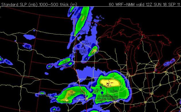 Sunday Showers
. It won't be an all-day rain on Sunday, but an approaching frontal boundary will probably squeeze out a few hours of showers. Saturday still looks like the drier, nicer day across most of Minnesota.
 Don't Pack Away The Shorts Just Yet.
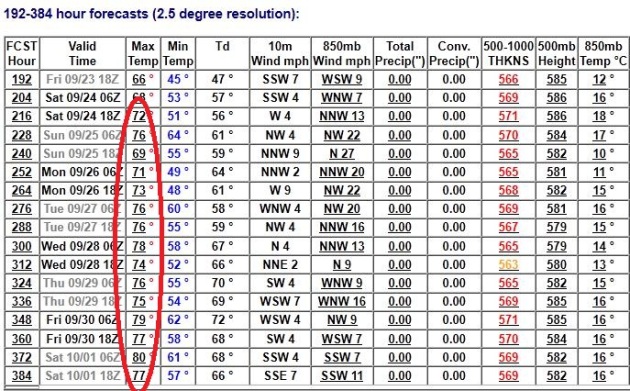
 I'm sure some people must think I'm mad ("but Paul, we've already had our first frost. It SNOWED in Duluth on Wednesday!") All true (including the mad part), but the one thing I've learned - the hard way - is that lukewarm weather tends to spill over into much of October. Sure, we'll see more cold fronts, but the GFS is showing an extended stretch of 70s, even some 80s the last week of September into the first few days of October. Time to rummage around for light jackets and sweatshirts, but I wouldn't retire the shorts just yet.
 Touch of October
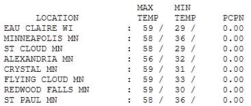
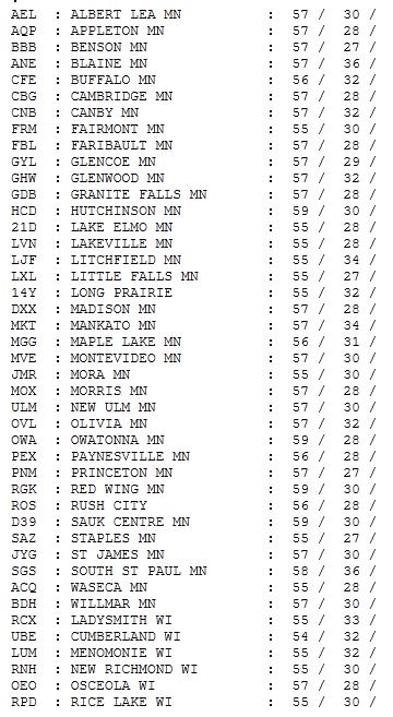
. Only Minneapolis and St. Paul (and close-in suburbs) avoided a frost early Thursday. Eau Claire and St. Cloud reported lows of 29, afternoon highs reached the upper 50s across most of Minnesota.
 Paul's Conservation Minnesota Outlook for the Twin Cities and all of Minnesota:
TODAY: Sun dimmed by high clouds. Winds: S 10-15. High: 62
FRIDAY NIGHT: Partly cloudy and dry. Low: 45
SATURDAY: Nicer day of the weekend; intervals of sun. Winds: S 15+ High: 63
SATURDAY NIGHT: Clouds and showers. Low: 53
SUNDAY: Few showers, possible thunder - few hours of rain. High: 67
MONDAY: Sunnier, drier and milder. Low: 53. High: 74
TUESDAY: Clouds increase, PM showers. Low: 56. High: near 70
WEDNESDAY: Gradual clearing, lukewarm. Low: 53. High: 71
THURSDAY: Plenty of sun, seasonable temperatures. Low: 52. HIgh: 68
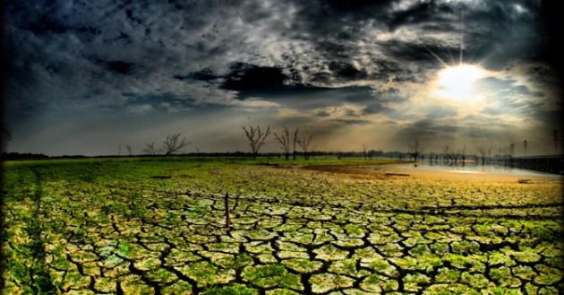
Crazy Extremes
Texas smolders through fire, heat and drought worse than the Dustbowl Days of the 1930s, a 7 month flood on the Missouri River, Vermont suffers historic flooding from dying Hurricane Irene.
According to reinsurer Munich Re, natural disasters during the first 6 months of 2011 approached $265 billion, 5 times more than the average losses for that period over the last decade.
Every day I come into WeatherNation, check the maps and shake my head in wonder. The last 18 months have been incredible, meteorologically; stuff I never thought I'd see in my lifetime. End of the world? Nope. This is what happens when a warmer atmosphere can hold more water vapor - priming the pump for more extreme and frequent storms.
August was the 8th warmest on record, worldwide. Tell that to residents of Duluth, where flurries were spotted on Wednesday. 19 F. at International Falls Thursday morning set a record for the earliest "teens". Unsettling...welcome to the New Normal.
Expect dim sun today; a dry sky lingers into Saturday (the nicer day). Showers arrive Saturday night and spill over into Sunday, highs in the low 70s.
But hold on: long-range models suggest 70s and 80s the last week of September.
Why Climate Change Is Real And Human-Induced. Here's a good overview from David Griggs, from the
Anglican Diocese of Melbourne (Australia): Professor David Griggs, Director of the Monash Sustainability Institute at Monash University, considers the evidence for human-induced climate change. Climate scientists are pretty much universally of the opinion that climate change is real, that we are seeing a warming of our climate, that the warming we observe is due to human emissions of greenhouse gases such as carbon dioxide caused when we burn fossil fuels, and that we are going to see an acceleration of that warming over coming decades. So why have we found it so hard to convince everyone else? Well, the most important reason is that the science is complicated, too complicated to explain in a sound-bite or even in an article like this. Our conclusions are not based on one fact or one piece of evidence, but on thousands of lines of enquiry, experiments, observations, models, computations etc. The bottom line is that since a scientist called John Tyndall, over 150 years ago, first discovered that gases such as carbon dioxide absorb and trap radiation, and the theory of global warming was born, all the evidence has ended up supporting and reinforcing the theory; and no other theory we have been able to come up with has been able to do this. And believe me we have tried – no climate scientist wants global warming to be real, it is not pleasant working day in, day out, being the bearer of bad news. And any scientist who did manage to disprove global warming would gain the kind of fame and fortune usually reserved for film and rock stars and there would be a Nobel prize to go along with it.
Here are just a few of the pieces of evidence that make us conclude that global warming is real:
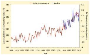
- The average temperature at the Earth’s surface has continued on an upward trajectory at a rate of 0.17C per decade over the last three decades
- Temperatures throughout the lower atmosphere (the troposphere) have also warmed consistent with the surface temperatures
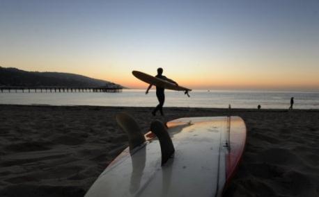
 Climate Change Threatens California Beaches: Study
.
AFB has the story: "
LOS ANGELES — Global warming could cost California beach communities hundreds of million dollars due to lost tourism and other income earned on the famously surfer-friendly coastline, a new study said. Storm damage and erosion will narrow beaches over the next century, cutting facilities for tourists and wildlife, said the report which looked at five coastal communities including Venice beach and Malibu. From the Beach Boys to "Baywatch," California is famous for its oceanfront lifestyle and year-round sunshine, but the Golden State needs to prepare for the encroaching Pacific, said the study commissioned by the California Department of Boating and Waterways. "California?s shorelines are ecologically, economically and socially important," it said. Coastal erosion, "which is projected to accelerate in the coming century," threatens ecosystems, reduces shoreline storm buffering capacities, and limits recreational opportunity, it said. "You need a certain amount of space for people to recreate, and, as beaches erode, you lose beach size and you lose tourism," said study author Phillip King, economics professor at San Francisco State University. Specifically the report looked at the impact of rising sea levels on five locations from San Diego in the south, to Los Angeles' Venice Beach and two seafront areas in Malibu, up to San Francisco's Ocean Beach."
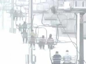
Ski Officials Warn Congress About Climate Change. The AP and
CBS Denver has the story: "
An Aspen skiing official and several ski athletes are heading to Washington to warn Congress about the consequences of climate change. Aspen Skiing Co. vice president Auden Schendler will be joined by Olympian snowboarder Gretchen Bleiler, pro skier Chris Davenport and pro snowboarder Jeremy Jones to testify on issues involving carbon emissions on Wednesday. According to the Aspen Daily News, Schendler says erratic weather including shorter winters and rain in the spring instead of snow has been a wake-up call for the ski industry, creating fears about the future of one of Colorado’s biggest industries."
The Science Of Why We Don't Believe Science. A must-read story from
Mother Jones:
"A MAN WITH A CONVICTION is a hard man to change. Tell him you disagree and he turns away. Show him facts or figures and he questions your sources. Appeal to logic and he fails to see your point." So wrote the celebrated Stanford University psychologist Leon Festinger (PDF), in a passage that might have been referring to climate change denial—the persistent rejection, on the part of so many Americans today, of what we know about global warming and its human causes."


No comments:
Post a Comment