13.54" rain during June, July and August in the Twin Cities (32nd wettest meteorological summer on record).
11th warmest summer since 1891 for MSP.
14 days above 90 this year (average is 13 days).
60 F. high in the Twin Cities Friday.
Today: drier day of the weekend, highs topping 60 over southern MN.
Sunday: 4-7 hours of showers, rainfall amounts under .25"
 Have A Nice Day!
 Yes, NOAA confirms we're sliding back into a (minor)
La Nina cooling phase of Pacific Ocean water, which correlates with somewhat colder and snowier winters for the northern tier states of the USA. I still don't believe we'll see 86" of snow this upcoming winter, but we may pick up more than usual (which is about 55"). The CPC, Climate Prediction Center, is predicting a slight bias toward colder than average temperatures from Montana to Minnesota into the Great Lakes for December, January and February. Place your bets.
"...
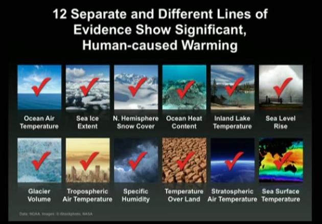
This is just one of the many reasons it is inconceivable for an entire scientific community to conspire en masse to mislead the public. In fact, if climate scientists truly wanted to maximize funding, we would be claiming that we had no idea why the climate is changing - a position that would certainly attract bipartisan support for increased research." - from a Houston Chronicle Op-Ed from Texas A&M climate scientist Andrew Dessler below.
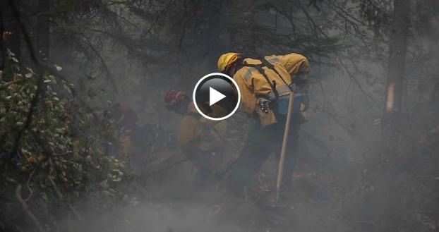
 Firefighters Gird For BWCA Blaze To Wake From 2-Day "Nap"
. The cooler weather and higher relative humidity levels helped firefighters make some progress with the BWCA blaze. But winds are forecast to increase, with a drop in humidity, and that may create more problems (and a larger fire) by early next week. One wild card: the MN Arrowhead may see as much as half an inch of rain late Saturday night into Sunday morning. That may be a God-send for firefighters. More from the
Star Tribune: "
ELY, MINN -- Firefighters were bracing Friday for a strengthening of the blaze that has engulfed more than 100,000 acres in the Boundary Waters Canoe Area Wilderness. With temperatures expected to reach 60 degrees, strong winds from the south and dry conditions in the forecast, fire crews were racing into position on the northern edge to contain the blaze. The fire could become even more unruly if it continues to creep north and reaches millions of dead trees from the 1999 blowdown. The fire's been "taking a nap the last two days," said Doug Anderson, spokesman for the fire command center in Ely. "But today it's going to wake up and we don't know what kind of mood it will be in." Firefighters have not contained any area of the blaze. Anderson said it could take months - and a heavy snowfall - before the fire is fully extinguished. About 500 firefighters are now in place to tackle it. Teams of the nation's most elite firefighters, called "hot shots," were making their way to the northwestern edge of the blaze to begin trying to get it under control. Some are being brought in with bush planes and others are paddling in with canoes."
Anger Builds Over Wait To Take On BWCA Fire. The
Star Tribune has more: "
The blaze that has consumed more than 156 square miles has reignited long-simmering local anger with a federal policy to let fires in the national wilderness area burn unless they threaten people or property. ISABELLA, MINN. - Larry Schanno walked out of a community meeting with fire officials Thursday morning and began tearing up. The fire churning through the Boundary Waters Canoe Area Wilderness already has decimated the lush and leafy area where he played as a child. Now it threatens his home. "What's really irritating is they let it burn for 11 days when they could have put it out," said Schanno, 63, a retired logger. "I don't understand the politics, but if there's a fire, they should fight the fire." The blaze that has consumed more than 156 square miles has reignited long-simmering anger here with a federal policy to let fires in the national wilderness area burn unless they threaten people or property. Light winds and cooler, wetter weather kept the flames from advancing more than about a quarter mile Thursday, but with firefighters bracing for warmer and windier weather this weekend, the signs of tension were everywhere. Fire officials worry that if the fire heads north, deeper into the wilderness area, it will encounter millions of tons of fuel from trees that fell to the 1999 blowdown. If it rushes south, it could be on the doorstep of Isabella."
"Fire Weather". Mark Seeley has an interesting post about the role of weather in the BWCA wildfire in his weekly
WeatherTalk summary: "
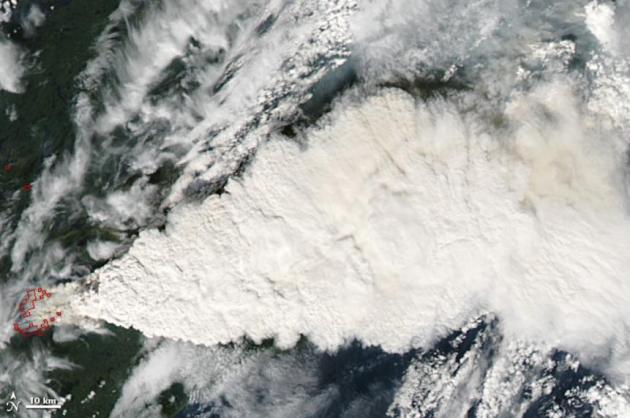
The spread of the Pagami Creek Fire in the BWCA this week was certainly assisted by the weather. A dry air mass with dewpoints only in the 20s and 30s F (15-20 degrees less than normal for this time of year) dominated the landscape earlier this week. Then modest southerly winds turned to strong northwesterly winds with gusts from 30 to 40 mph, allowing flames to jump gaps in the forest and ignite other canopies and understory materials. Fortunately light rains over the 13th and 14th abated faster and further spread of the fire, still one of the largest (over 100,000 acres) in Minnesota history. The MODIS sensor aboard NASA's Terra Satellite captured the Pagami Creek Fire as it grew earlier this week and produced some pyrocumulonimbus cloud forms."
Photo credit above: NASA's
Earth Observatory. "
Large fires can do more than scorch vegetation and clog the skies with smoke. They can actually create their own weather. By heating the air overhead, fires push the warmed air upward. Mixed with smoke, the air rises high enough for its water vapor to condense and form clouds. If the air rises fast enough, the water vapor forms ice crystals that charge the cloud with electricity, and lightning often results. These fire-provoked thunderstorm clouds are known as pyrocumulonimbus clouds. Minnesota Public Radio reported that the plume from the Pagami Creek Fire was picked up by doppler radar."
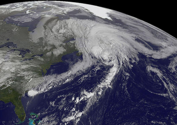
Hurricane Maria Nears Tip Of Newfoundland With 80 MPH Winds. Hurricanes in Newfoundland? Unusual, yes. Most hurricanes weaken into tropical storms or depressions before reaching such a northerly latitude. But this year warm Gulf Stream Waters are 2-4 F. warmer than average, helping to maintain Maria as a hurricane over the Canadian Maritimes.
Bloomberg Businessweek has more details:
"Hurricane Maria sped toward Newfoundland and is expected to cross the Canadian island later today with winds of at least 74 miles (119 kilometers) per hour, the National Hurricane Center said. Maria, with 80 mph winds, was racing northeast across the Atlantic at 45 mph, the center said in an advisory at 8 a.m. Miami time. The storm was 375 miles southwest of Cape Race, Newfoundland, and is forecast to strike Placentia Bay before passing north of St. John’s, an offshore oil and gas hub. Winds are already picking up on the island, the NHC said. The center of Maria, a Category 1 storm on the 5-step Saffir-Simpson scale, “should pass near or over extreme southeastern Newfoundland this afternoon,” the NHC said. “Little change in strength is expected before Maria moves over southeastern Newfoundland.” Energy companies including Exxon Mobil Corp., Royal Dutch Shell Plc and Hibernia Management & Development Co. have offshore facilities near the storm’s projected path, according to Bloomberg data. Hurricane Igor hit the island last year, killing three people and causing $200 million in damage."
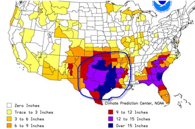
Additional Rainfall Necessary To Ease Drought. According to NOAA's Climate Prediction Center over 15" of rain is needed over much of eastern Texas and southern Oklahoma to pull counties out of an exceptional drought situation. That's roughly 2 hurricane's worth of rain. Parts of Georgia, the Carolinas and Florida's panhandle are nearly as dry as the Southern Plains.
PUBLIC INFORMATION STATEMENT
NATIONAL WEATHER SERVICE BALTIMORE MD/WASHINGTON DC
932 AM EDT WED SEP 14 2011
...RECENT HEAVY RAINFALL WAS A RARE EVENT...
THE MID-ATLANTIC REGION...ESPECIALLY FROM WASHINGTON AND BALTIMORE
EASTWARD...HAVE RECENTLY BEEN AFFECTED BY BOTH HURRICANE IRENE AND
A WET PERIOD CAUSED LARGELY BY THE REMNANTS OF TROPICAL STORM LEE.
SOME OF THE HIGHEST RAINFALL TOTALS OVER THE LAST 30 DAYS INCLUDE...
TRUMAN DRIVE IN LARGO 24.13
CABIN BRANCH - FORESTVILLE 23.98
LEELAND ROAD IFLOWS 23.62
HERRING ROUTE 40 BALTIMORE 23.11
BRISTOL 23.04
BOWIE 22.90
PRINCE GEORGES JUSTICE CTR 22.87
LAKE ARBOR - LARGO 22.52
DISTRICT HEIGHTS 21.49
KINGSTOWNE - FAIRFAX 20.34
FORT MCHENRY 19.83
FORT BELVOIR 18.61
BWI AIRPORT 17.43
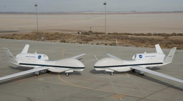
Global Hawks Prepare For 2012 Hurricane Season. I'm starting to wonder if (manned) hurricane hunter flights into hurricanes will (someday) be replaced by remote-controlled drones, able to collect the same information (at lower cost). Here's an article from
redorbit.com: "
A group of environmental scientists has set up an office in an aircraft hangar at NASA’s Dryden Flight Research Center at Edwards, Calif., in preparation for a multi-year airborne science investigation of hurricane formation and intensification. As they work on their computers, the scientists are also monitoring the installation and testing of specialized weather-monitoring instruments on one of NASA’s Global Hawk remotely operated unmanned aircraft. This hands-on approach to research is part of a critical buildup to a hurricane study sponsored by NASA’s Earth Venture Program that begins collecting data next summer. NASA’s Hurricane and Severe Storm Sentinel, or HS3, investigation is a multi-year study of the processes that underlie hurricane formation and intensity change in the Atlantic Ocean. “The high-altitude and long-duration capabilities of NASA’s Global Hawks allow HS3 to sample storms virtually anywhere in the Atlantic and for durations up to three times that of conventional aircraft,” said principal investigator Scott Braun of NASA’s Goddard Space Flight Center in Greenbelt, Md. “Being able to stay over a storm for 15 or more hours allows us to observe storms in ways that were simply not possible before.” HS3 conducted two checkout flights of one of NASA’s Global Hawks, one of 24 hours duration Sept. 8 – 9 over the Pacific Ocean and the second of about 19.5 hours on Sept. 13 – 14 over the Gulf of Mexico. Data were gathered by three scientific instruments that will be used during the mission."
Photo credit above:
"
Their bulbous noses almost touching, NASA’s two Global Hawks lined up nose-to-nose on the ramp at NASA’s Dryden Flight Research Center on Edwards Air Force Base. Bearing NASA tail numbers 871 and 872, the two autonomously operated unmanned aircraft will be flown during the coming multi-year HS3 hurricane study. (NASA / Tony Landis)"
 Strange But True: FEMA Determines How Bad A Hurricane Is By Seeing If Waffle House Is Open
. Something from the Onion? Nope. Sadly, this one appears to be true.
Gizmodo.com has the details: "
This seems lifted from The Onion but it's not. According to the WSJ, FEMA Administrator Craig Fugate uses a 'Waffle House Index' to help him determine how destructive a hurricane has been to an area. If a Waffle House is closed, you're probably screwed. Specifically, in Fugate's interpretation: Green means the restaurant is serving a full menu, a signal that damage in an area is limited and the lights are on. Yellow means a limited menu, indicating power from a generator, at best, and low food supplies. Red means the restaurant is closed, a sign of severe damage in the area or unsafe conditions. This is real life, people! If the Waffle House is closed get the hell out of Dodge. Or as Fugate puts it, "If you get there and the Waffle House is closed? That's really bad."
 Feels Like Autumn
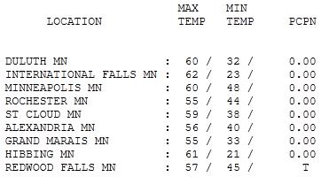
. Under a mostly cloudy sky (central and southern MN - the sun was out most of the day over the northern third of the state) temperatures were about 10 degrees cooler than average, ranging from 55 at Rochester and Grand Marais to 59 in St. Cloud, 60 in the Twin Cities and 62 at International Falls (where the sun was out all day).
Paul's Conservation Minnesota Outlook for the Twin Cities and all of Minnesota:
TODAY: Nicer day of the weekend. Some sun, stiff breeze, nicer day of the weekend. Winds: SE 15-25. High: 62
SATURDAY NIGHT: Cloudy with rain developing. Low: 54
SUNDAY: Mostly cloudy with showers likely. Winds: S 10. High: 60
MONDAY: Plenty of mild sun, pleasant. Low: 53. High: 72
TUESDAY: Passing showers, thunder? Low: 54. High: near 70
WEDNESDAY: Mix of clouds and sun, breezy and cooler. Low: 51. High: 65
THURSDAY: Sunny and beautiful. Low: 48. High: 71
FRIDAY: Mild breeze, warming up. Low: 53. High: 74
A Quiet Spell
Freakishly early flurries and freezes notwithstanding, September is a fine month here in Minnesota. Days are lukewarm, lakes still mild enough for a dip, severe storms exceedingly rare, dew points dropping off to comfortable levels.
Thursday's premature freeze may impact Minnesota's soybean harvest; less concern about the corn and wheat crop.
Severe drought has returned to the Arrowhead, helping to fuel the BWCA Pagami blaze. So I won't complain one bit when I mention the smear of rain on tap for tonight and Sunday morning; half an inch or more may fall. A soggy Sunday morning should give way to some sun by late afternoon, temperatures close to normal next week (highs near 70).
For the record, 13.54" rain fell during meteorological summer (32nd wettest since 1891). The summer of 2011 was the 11th warmest on record, according to Pete Boulay at the State Climate Office. One big silver lining: only 30 Minnesota tornadoes in '11, compared to a nation-leading 145 twisters in 2010.
Puddle potential? Sunday, again Tuesday. Next weekend may bring enough sun for highs near 80.
NOAA warns of another tough La Nina winter? La Nina, La Schmeena! First comes a fine autumn.
Peter C.Frumhoff and Kerry Emanuel: Two Parties, One Approach To Climate Science. This is the kind of bipartisan cooperation we need to get something moving in Congress.
The Californian reports: "
When it comes to foreign policy, the saying goes that politics stops at the water's edge. When it comes to climate science, we say that politics should stop at the atmosphere's edge. One of us is a Republican, the other a Democrat. We hold different views on many issues. But as scientists, we share a deep conviction that leaders of both parties must speak to the reality and risks of human-caused climate change, and commit themselves to finding bipartisan solutions. Scientists have known for more than 100 years that carbon dioxide in our atmosphere traps heat. And today we know that the excess carbon dioxide accumulating in the atmosphere from human activity — primarily, burning coal and oil and clearing forests — is altering our climate. It's a conclusion based on established physics and on evidence gathered from satellite data, ancient ice cores, temperature stations, fossilized trees and corals. And it's a conclusion affirmed by the U.S. National Academy of Sciences, established by President Lincoln to advise our nation's leaders on matters of science.But as scientific understanding of climate change has advanced, the public discourse has split along partisan lines."
 Perry Shoots The Messenger On Climate Change
. Here's a Houston Chronicle Op-Ed from Texas climate scientist Andrew Dessler at Texas A&M: "
Texas Gov. Rick Perry stirred up a controversy recently when he dismissed the problem of climate change and accused scientists of basically making up the problem. As a born-and-bred Texan, it's especially disturbing to hear this now, when our state is getting absolutely hammered by heat and drought. I've got to wonder how any resident of Texas - and particularly the governor who not so long ago was asking us to pray for rain - can be so cavalier about climate change. As a climate scientist at Texas A&M University, I can also tell you from the data that the current heat wave and drought in Texas is so bad that calling it "extreme weather" does not do it justice. July was the single hottest month in the observational record, and the 12 months that ended in July were drier than any corresponding period in the record. I know that climate change does not cause any specific weather event. But I also know that humans have warmed the climate over the last century, and that this warming has almost certainly made the heat wave and drought more extreme than it would have otherwise been. I am not alone in these views. There are dozens of atmospheric scientists at Texas institutions like Rice, the University of Texas and Texas A&M, and none of them disputes the mainstream scientific view of climate change. This is not surprising, since there are only a handful of atmospheric scientists in the entire world who dispute the essential facts - and their ranks are not increasing, as Perry claimed."
Gore Takes Climate Change Slide Show Around The World In 24 Hours. Here's an update on Al Gore's latest attempt to get the word out about climate change from the
New York Times: "
Five years after the release of his Academy Award-winning documentary, former Vice President Al Gore is once again attempting to build awareness and momentum behind action on climate change with a slide show. The "24 Hours of Reality" program, created by Gore's Climate Reality Project, started at 8 p.m. EDT on Wednesday in Mexico City, concluding with a speech from the former vice president. Speaking from New York City yesterday evening, Gore said the program marks a new era for action. "Climate change is really not a political problem. It is a human problem," said Gore. "We can start by addressing the deniers of climate change." The presentations consisted of a one-hour slide show in 13 languages highlighting the dangers of climate change, tailored to the local presenters and staggered across every time zone over the course of a day. The entire program can be seen online at ClimateRealityProject.org. The website's counter indicated 8.5 million people viewed the site while the presentations were streamed live. Slides prominently featured large natural disasters over the past few years, showing scenes from floods in Australia and Pakistan, droughts in East Africa, and hurricanes along America's Atlantic Coast, and linked these weather events to shifting climate patterns. "Global warming has changed the conditions in which all storms form," said Gore, who quoted a scientist stating that the phenomenon represents a "new normal."
Is Al Gore Now A Help Or Hindrance To The Global Warming Cause? An Op-Ed from the U.K.
Guardian: "
Death by Powerpoint. I have suffered this torture too many times over the years. We all probably have. So I was a little nervous this morning logging into Climate Reality – Al Gore's 24-hour global-warming warning – as to what I might discover. And, I have to say, my heart immediately sank. A no-doubt sincere presenter from the Solomon Islands was showing slide after slide of extreme weather events around the world that have occurred over the past year and linking everyone, it seemed, to the rise in anthropogenic greenhouse gas emissions. As anyone who follows the climate debate closely knows, that is a very contentious peg on which to hang your hat. That kind of talk traditionally requires lots of caveats and careful explaining. Done with abandon and raw emotion – as this presenter seemed to be doing – and you are quickly labelled in some quarters as a climate "alarmist". And, for me, this is one of the key challenges the Climate Reality project faces. Who exactly is it trying to convince with its urgent, sometimes breathless campaign? Is it preaching to the converted? If so, it is doing a good job."
More Americans Believe World Is Warming. Here's an update from
Reuters: "
WASHINGTON, Sept 15 (Reuters) - More Americans than last year believe the world is warming and the change is likely influenced by the Republican presidential debates, a Reuters/Ipsos poll said on Thursday. The percentage of Americans who believe the Earth has been warming rose to 83 percent from 75 percent last year in the poll conducted Sept 8-12. U.S. Republican presidential candidates, aside from Jon Huntsman, have mostly blasted the idea that emissions from burning fossil fuels and other human actions are warming the planet. The current front-runner, Texas Governor Rick Perry, has accused scientists of manipulating climate data while Michele Bachmann has said climate change is a hoax. As Americans watch Republicans debate the issue, they are forced to mull over what they think about global warming, said Jon Krosnick, a political science professor at Stanford University. And what they think is also influenced by reports this year that global temperatures in 2010 were tied with 2005 to be the warmest year since the 1880s. "That is exactly the kind of situation that will provoke the public to think about the issue in a way that they haven't before," Krosnick said about news reports on the Republicans denying climate change science."
Study Claims Global Warming Is "Beneficial" For Human Health. Right. More flooding, tornadoes, droughts, heatwaves and wildfires will definitely be a positive for human health worldwide. It's true, we may see fewer subzero nights, less arctic air overall, but most climate experts believe the downside of a warmer, stormier atmosphere will negate any upside. The
International Business Times has more: "
The authors of the new report say “the net effect of continued warming and rising carbon dioxide concentrations in the atmosphere is most likely to be beneficial to humans, plants, and wildlife.” The report says that “global warming is more likely to improve rather than harm human health because rising temperatures lead to a greater reduction in winter deaths than the increase they cause in summer deaths.” The researchers found that global warming “benefits” not only mammals but amphibians, birds, butterflies and insects also benefit from its myriad ecological effects. The reports also states that the Medieval Warm Period of approximately 1,000 years ago was both “global and warmer than today’s world.” The latest research reveals that corals and other forms of aquatic life have effective adaptive responses to climate change enabling them to flourish. It says that averting hunger and ecological destruction in the future can be done by increasing crop yield, which will be aided by rising temperatures and atmospheric CO2 concentrations."


No comments:
Post a Comment