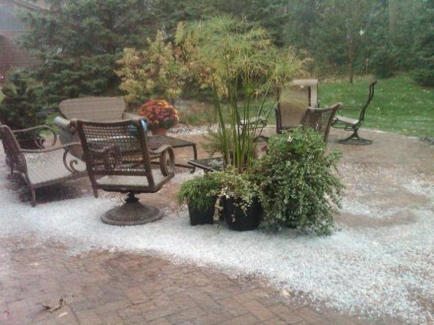
No rain expected this week, temperatures forecast to run 3-5 degrees cooler than average.
Frost possible by Wednesday morning, even in the close-in suburbs of the Twin Cities. I suspect the immediate downtowns will remain frost-free for the next 7-10 days.
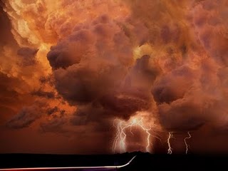
Major storm brewing for the east coast, potential for heavy rain, even a rare October severe storm outbreak by Wednesday and Thursday.
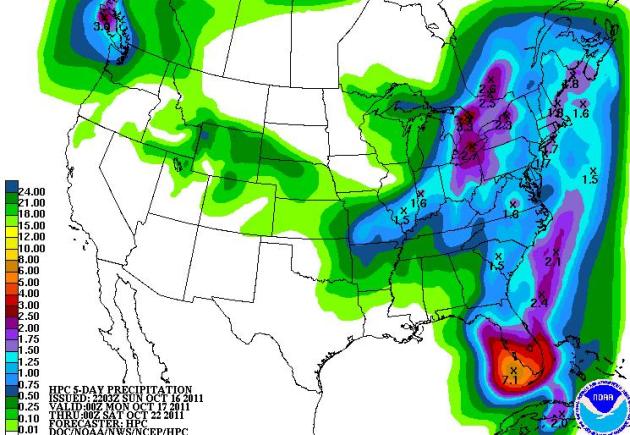
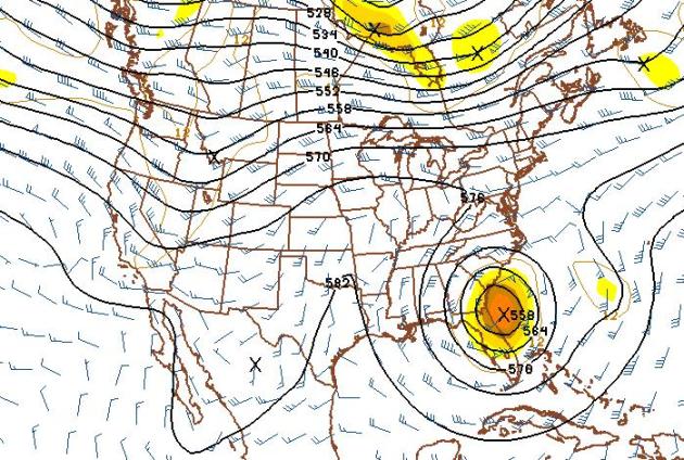
Soggy East - Dry West. A very stormy pattern is shaping up for the eastern USA, heaviest rains predicted for south Florida (5"+ rains) and portions of New England, where some 2-3" rains are likely. 5-day rainfall map above courtesy of NOAA.
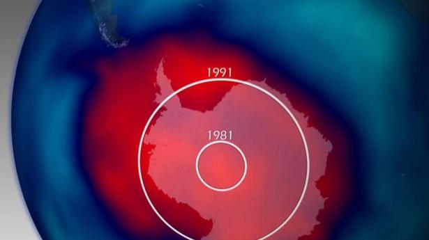
Antarctic Ozone Hole Now As Big As North America. CBS News and LiveScience have the details: "The ozone hole above the Antarctic has reached its maximum extent for the year, revealing a gouge in the protective atmospheric layer that rivals the size of North America, scientists have announced. Spanning about 9.7 million square miles (25 million square kilometers), the ozone hole over the South Pole reached its maximum annual size on Sept. 14, 2011, coming in as the fifth largest on record. The largest Antarctic ozone hole ever recorded occurred in 2006, at a size of 10.6 million square miles (27.5 million square km), a size documented by NASA's Earth-observing Aura satellite. The Antarctic ozone hole was first discovered in the late 1970s by the first satellite mission that could measure ozone, a spacecraft called POES and run by the National Oceanic and Atmospheric Administration (NOAA). The hole has continued to grow steadily during the 1980s and 90s, though since early 2000 the growth reportedly leveled off. Even so scientists have seen large variability in its size from year to year."
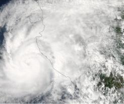
Close Call For Puerto Vallarta, Mexico. Decodedscience.com has more details on Hurricane Jova, which hit the west coast of Mexico last week: "This week, Hurricane Jova hit the Pacific coast of Mexico, causing property damage in the order of 50 million. Flooding and mudslides caused the majority of the damage. Thousands evacuated their homes, and the storm is blamed for at least five deaths. Speeding toward land with 100 mph winds, Jova hit the coast just west of the port of Manzanillo. A mudslide and a collapsing home were responsible for four of the deaths in this week’s storm. Flood waters claimed the life of a woman who was trapped in her car. The hurricane passed within 15 miles of Puerto Vallarta, a internationally-renowned beach resort. Fortunately, the resort was on the weaker side of the hurricane and residents only experienced strong winds and rain. Jova’s strength waned as it passed over Mexico late this week. In a typical hurricane season, the eastern Pacific experiences nine hurricanes. Jova was the ninth hurricane of the 2011 season."
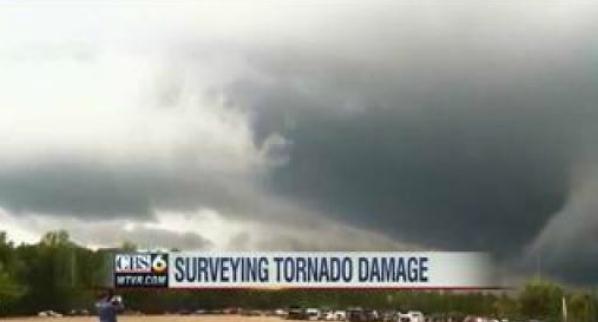
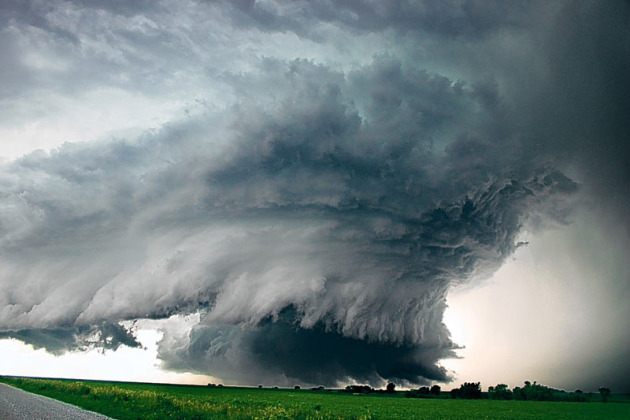
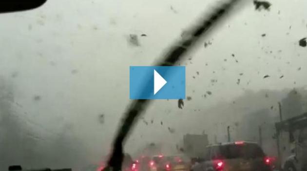
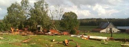
Neighborhood Damaged By Hurricane Irene Now Trashed By Tornado. WTVR-TV in Richmond has the details: "NEW KENT COUNTY, VA (WTVR) - Neighbors living in the Woodhaven Shores subdivision of New Kent County, Virginia are cleaning up the mess left behind by a Thursday afternoon tornado. This same neighborhood suffered extensive damage following Hurricane Irene in August. "We all expected this can happen at any time,” said Erik Lindstrom. “But to get hit like twice in a row. It's a real shock. " Thursday's tornado uprooted trees, knocked tree branches on homes and knocked power lines to the ground. [PHOTOS: Tornadoes hit Central Virginia] "There's nothing you can do about it. It's a force of nature. There's really no way to prevent it,” said Matt Segreto."
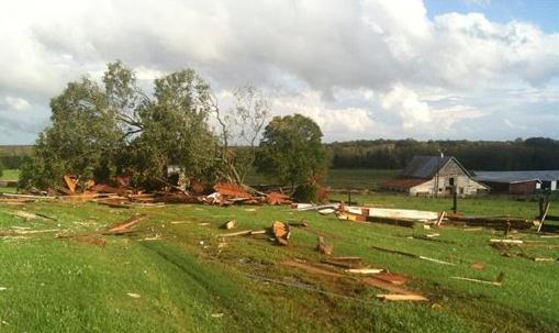
No Aid For Town Rocked By Earthquake, Hurricane And Tornado. More on the little Virginia town of Louisa, which has experienced a disaster trifecta this year. Hamptonroads.com has the head-shaking details: "Residents of this rural community just outside Richmond know they may be lucky, seeing as how no one died in the earthquake, hurricane and tornado that have hit back-to-back-to-back in the past few months. That doesn't mean they aren't bitter: "Louisa cares: Because the feds don't," read Friday's headline atop the local newspaper. The federal government has refused to help foot the $18 million tab for the damage from the disaster trifecta, most of which was caused by the earthquake, leaving people to host fundraisers and help out neighbors because few homes and businesses had insurance. But they say they can't do it alone. Many look at how bad things could have been and note no one was killed in any of the disasters that began when the 5.8-magnitude earthquake began in Louisa County on Aug. 23 and rumbled all along the East Coast. The hurricane and tornado were far less destructive — the former bringing mostly heavy rain and wind gusts, the latter damaging only a plantation home dating to the 18th century. Still, they hope they're in the clear for a while."
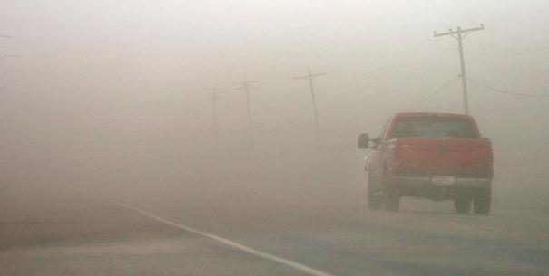
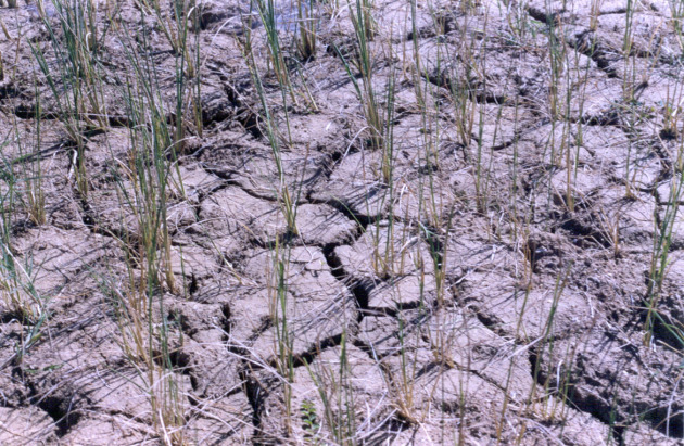
Drought Expected To Bring More Dust Storms To Texas. The Texas Tribune has the story: "Despite last weekend's rains, the Texas drought lingers -- and experts say the number of irritating and dangerous dust storms could increase across the state, especially in West Texas and the Panhandle. A dust storm rolled in from the north and filled the skies above Jones AT&T Stadium with a beige haze during a Texas Tech football game last month in Lubbock. "Normally, this just doesn't happen during a football game," said Ted Zobeck, a research soil scientist for the USDA's Agricultural Research Service. "Crops are usually covering the ground, preventing mass amounts of particles from blowing. But that's not the case in this drought." As of today, a map from The National Drought Mitigation Center showed that 73 percent of Texas is in the worst drought stage. More than 90 percent is in the extreme drought stage. "There are three things you need to cause a dust storm: wind, loose soil and a lack of vegetation," said Nolan Clark, a former lab director at the Agricultural Research Service in Bushland. "And when you don't have enough water to grow vegetation, there's nothing stopping those loose particles from blowing around. We are going to have a very dirty winter."
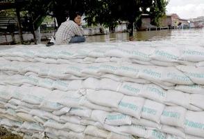
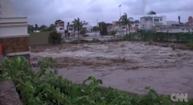
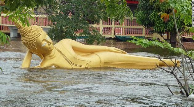
Flood Barriers Ringing Bangkok's Outskirts Will Determine Thai Capital's Fate. The monsoon flooding gripping much of southern Asia is historic - impacting as many as 8 to 10 million residents of Thailand, Laos, Cambodia and Vietnam. The Washington Post has more on an urgent struggle to protect the capital of Thailand: "RANGSIT, Thailand — Beside a wall of white sandbags that has become a front line in Thailand’s battle to prevent an epic season of monsoon floods from reaching Bangkok, needlefish swim through knee-high water inside Sawat Taengon’s home. On one side, a cloudy brown river pours through a canal diverting water around the Thai capital, just to the south. On the other side, homes just like his are unscathed. Whether floodwaters breach fortified barriers like these this weekend will decide whether Bangkok will be swamped or spared."
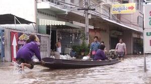
Thai Floods: Eyewitness Accounts. The BBC has more on the record flooding that has inundated much of Thailand: Canals have been drained to allow for excessive water flow and sandbags have been piled up around the city. Nicola Gurney is an English teacher in Nakhon Sawan, a city that has been badly affected by the floods.
"The situation in Nakhon Sawan is really bad. "The city is under several metres of water and people are saying that the levels won't go down for another month. "Every school, college, orphanage, temple or stadium that is still on dry land is being used to house the homeless while we wait for the water to recede. "Initially it looked as though we would escape the worst of the flooding as the city has flood defences but there was an accident. A boat ran up against the flood walls allowing the water to come into the city. Soon the levels were over two metres. "I'm staying in the temple where I teach English to novice monks. There are 1300 of us here and many of the evacuees have lost everything. "Most of our friends have lost their homes. The hospitals have had to be evacuated."

More tornadoes in North Carolina (107) than Texas (105) this year. Source: SPC. More details below.
...THE FOURTH WETTEST YEAR AT CENTRAL PARK...

SO FAR...61.86 INCHES OF PRECIPITATION HAS FALLEN AT CENTRAL PARK
FROM JANUARY 1 THROUGH 1100 AM TODAY OCTOBER 14...MAKING 2011 THE
FOURTH WETTEST YEAR RECORDED AT CENTRAL PARK.
THIS IS 22.31 INCHES ABOVE NORMAL FOR THE YEAR TO THIS DATE. RECORDS
DATE BACK TO 1869.
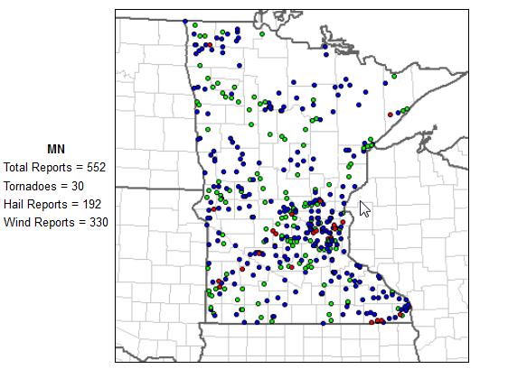
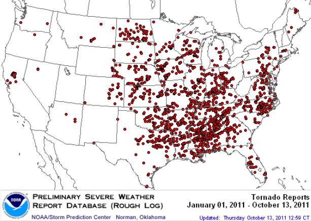
Alabama: 166 (most in the USA)
Mississippi: 155
North Carolina: 107
Texas: 105
Iowa: 68
Wisconsin: 49
Minnesota: 31
“Louisiana producers can continue to count on USDA to provide emergency assistance during difficult times,” said Agriculture Secretary Tom Vilsack. “America’s farmers and rural communities are vitally important to our nation’s economy, producing the food, feed, fiber and fuel that continue to help us grow and out-compete the rest of the world. President Obama and I arecommitted to using the resources at our disposal to reduce the impact of Tropical Storm Lee and other disasters affecting Louisiana producers and help to get those affected back on their feet.”
Farmers and ranchers in the following counties in Arkansas, Mississippi and Texas also qualify for natural disaster assistance because their counties are contiguous."

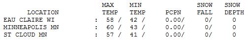

Respectable Saturday. O.K. It wasn't perfect (clouds did increase by late afternoon, especially south/west of the Twin Cities). But the sun was out much of the day, enough blue sky for 57 at St. Cloud, 60 in the Twin Cities and 61 at Redwood Falls - pretty close to average, in spite of a stiff northwest wind gusting to 30 mph at times.
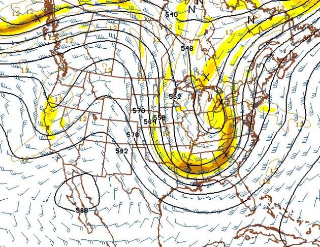
Full-Latitude Trough. The 500 mb forecast maps look VERY impressive for a major storm from the Great Lakes to the east coast Wednesday and Thursday. That may translate into heavy rain, even a rare severe weather outbreak for the eastern seaboard, with a potential for wet snow mixing in from the Appalachians into the highest elevations of New England by the end of the week.

Paul's Conservation Minnesota Outlook for the Twin Cities and all of Minnesota:
TODAY: Partly sunny, blustery and cooler. Winds: NW 15-30. High: 56
SUNDAY NIGHT: Clear to partly cloudy - chilly. Low: 39
MONDAY: Mix of clouds and sun, windy and cool. High: 55
TUESDAY: More clouds, few sprinkles. Flurry north. Low: 36. High: 49
WEDNESDAY: Frosty start? Sunny, less wind. Low: 32. High: near 50
THURSDAY: Blue sky, a bit milder. Low: 34. High: 55
FRIDAY: Fading sun, breezy, seasonable temperatures. Low: 42. High: 57
SATURDAY : Clouds increase, stray shower? Low: 42. High: 55
"Disaster Trifecta"
You think you're having a bad year? Give thanks you don't live in Louisa, Virginia. A 5.8 magnitude quake strikes on August 23, then Hurricane Irene hits 4 days later. The same town is picking up the pieces after a tornado outbreak last Thursday. "What's next and how much more does the good Lord think we can take?" one resident asked. The eye-opening AP article is on my blog.
Minnesota got off relatively easy: 31 tornadoes (down from 145 last year - most in the USA). Iowa saw 68 tornadoes, but Alabama saw the most in 2011: 166.
Our claim to fame: 103 hours with an extreme dew point over 75 F. According to Pete Boulay at the State Climate Office the first 13 days of October were the warmest since 1879 in the metro area. After a summer of nearly perfect soil moisture for Minnesota farmers a drought is deepening, especially over far southern Minnesota. If we don't get a few big rain storms soon (before the ground freezes solid in mid November) farmers may be impacted next spring.
The pattern favors big storms on the east coast; but a persistent west/northwest steering wind aloft keeps us cool and quiet through Halloween.
I'm not complaining. Payback arrives next month.

Cameras Get To The Root Of Global Warming. There's a Minnesota angle here - using sophisticated micro-cameras to track subtle changes in Minnesota's bogs. Vision-systems.com has the story: "Ultimately, the minirhizotrons will be placed in a black spruce bog in Minnesota, the site for a multiyear experiment called SPRUCE (Spruce and Peatland Responses Under Climatic and Environmental Change). There, large, modified open-top chambers will allow researchers to manipulate air and soil temperatures and levels of carbon dioxide and evaluate the response of the ecosystem. One of the reasons scientists are interested in high-carbon environments like the Minnesota bog is because they cover only 3% of global land surface but store nearly one-third of terrestrial carbon. If the planet continues to warm, researchers hypothesize that bogs will dry out and the following microbial decomposition of organic matter could lead to a massive release of carbon dioxide into the atmosphere, resulting in more warming."
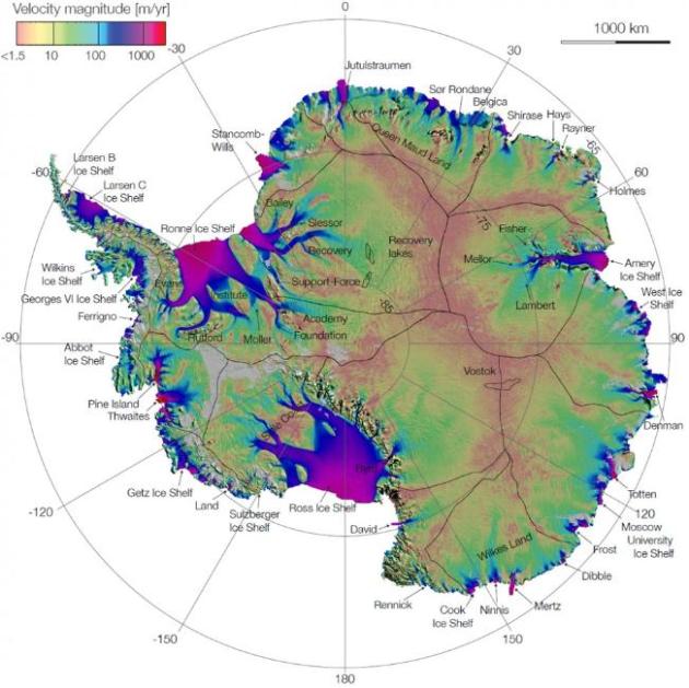
NASA Continues Survey Of Antarctica's Changing Ice To Assess Global Warming. The International Business Times has the story: "Scientists with NASA's Operation IceBridge are set to embark on its third year of aerial surveys of Antarctica's changing ice cover. Researchers are flying a suite of scientific instruments on two planes from a base of operation in Punta Arenas, Chile. The two planes are a DC-8 operated by NASA and a Gulfstream V (G-V) operated by the National Science Foundation and the National Center for Atmospheric Research. The DC-8, which completed its first science flight Oct 12, will fly through mid-November, with the G-V flying through early November. 98 per cent of the continent is covered in ice, and scientists say monitoring the changes to the ice is vital to track the impact of global warming."

Columbus Blamed For "Little Ice Age". OK, this headline may not be as crazy as it sounds at first blush. Science News has the story: "MINNEAPOLIS — By sailing to the New World, Christopher Columbus and the other explorers who followed may have set off a chain of events that cooled Europe’s climate for centuries The European conquest of the Americas decimated the people living there, leaving large areas of cleared land untended. Trees that filled in this territory pulled billions of tons of carbon dioxide from the atmosphere, diminishing the heat-trapping capacity of the atmosphere and cooling climate, says Richard Nevle, a geochemist at Stanford University......Tying together many different lines of evidence, Nevle estimated how much carbon all those new trees would have consumed. He says it was enough to account for most or all of the sudden drop in atmospheric carbon dioxide recorded in Antarctic ice during the 16th and 17th centuries. This depletion of a key greenhouse gas, in turn, may have kicked off Europe’s so-called Little Ice Age, centuries of cooler temperatures that followed the Middle Ages."
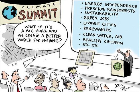

"This entire discussion misses the point that for severe climate change for many regions there is no such thing as adaptation.
Adaptation implies that you stick around and find a solution to what is hitting you. You know, like building dykes, finding alternative sources of water, making buildings stronger so that they can withstand increasingly severe storms, etc.
How do you adapt to a good portion of Florida being under water and most of the underground water being ruined by salt infiltration?
There is no adaptation. You lost.
Let's suppose a good portion of Texas becomes a dustbowl -- nothing can be grown on it. The dust storms and winds are so bad that solar and wind power plants become useless.
Another fail -- you lost again.
What about northern Canada? The melt will be so severe that the permafrost becomes perma-mush and nothing can be transported in or out by road. Pipelines sink into the mush and break.
Major fail -- you lost again.
Let's suppose that the warming becomes so severe in the Arctic that Greenland's ice sheet loses so much of its mass due to melting that the thermohaline circulation goes wacky for a decade causing major disturbances to agriculture, leading to a 50% loss in global food production.
Do you adapt to that? Nope.
Let's suppose that the Midwest goes through a severe drought, then a 500-year flood, then a drought, then another 500-year flood, then another drought....
Can farmers adapt to that? Just ask one."
No comments:
Post a Comment