SATURDAY: Unsettled - still unseasonably mild, few showers or T-showers. SW 10-15. High: 78
SATURDAY NIGHT: Passing shower or storm possible. Low: 58
SUNDAY: Showers linger, still mild. High: 75
MONDAY: Cool front stalls, chance for showers and storms lingers, mainly across western MN. Low: 55. High:74
TUESDAY: Intervals of sun, still milder than average. Slight chance of an isolated shower. Low: 54. High: 73
WEDNESDAY: Isolated shower possible early, then turning breezy with some sun. Low: 55. High: 69
THURSDAY: Mix of clouds and sun. More clouds across northern MN with a passing shower. Feeling like October again. Low: 51. High: 61
FRIDAY: More sun, but much cooler. Low: 42. High: 59
Road to Historic Tettegouche Camp Tettegouche State Park
Paul Sundberg snapped this picture of a mother and daughter spending some quality time together in a beautiful setting. He says a walk together hand in hand, making memories is something everyone should do with their kids or grandkids this weekend and head for the nearest State Park as the colors are spectacular! I agree Paul, here's to another great shot!
You can check out Paul's other amazing work at his website:
Windy Friday
Anyone else notice that when it's windy the toilet water sloshes? Think I'm crazy... check it out, the next time it is windy in your neck of the woods :)
Thanks for Katie Ferrier Meteorologist from WeatherNation for this graphic, look at those High Wind Gusts Reports Friday - WOW!!
"There's A Tree Down in the Front Yard Grandma!"
I was finally able to make it out to Wisconsin to see my Grandma and Grandpa to show them our nearly 4 week old baby boy Cashton on Friday, but we almost got stuck there! The strong winds on Friday knocked this big white oak down near their driveway. I typically don't carry a chainsaw and a wood chipper when I'm traveling, so I'm thankful some of the neighbors showed up to help out.
Thanks to Katie Klarkowski, a student from SCSU, who was driving in the Rice area this afternoon for this picture. Her caption yesterday was, "Don't see this everyday. Blowing dust conditions near Rice."
Meanwhile, Back at the Ranch...
Showers and thunderstorms developed yesterday across parts of Minnesota for the first time in a long time. It was actually kind of nice to see some thunderstorms again before we head into the snow season, which to be honest... isn't that far away.
(Radar From Friday Night)
Good News and Bad News...
With lawn and gardens as crunchy as they are, the good news is that rain is in the forecast... the bad news is that the rain doesn't look to be all that widespread. The pseudo cool front, which is turning out to be more of a stalled frontal boundary is going to keep the rain and thunder potential more linear rather than widespread.
Where Do We Go From Here?
This slow moving front is going to give some folks much needed and beneficial rain. Take a look at the 3 day accumulated rainfall forecast. The heavies of the rain looks to stay in the Southern Plains as showers and thunderstorms develop in nearly the same areas over the next few afternoons and evenings.
It's Been Warm So Far...
This is from the NWS in the Twin Cities:
"The record high of 85 degrees was tied at Minneapolis St. Paul International Airport today. The high also reached 85 degrees on October 7th in 1997 and 2003. The normal high for October 7th is 62 degrees.This is the 6th day in a row that the high temperature has been at or above 80 degrees in the Twin Cities. This is the longest streak of 80 degree days in the Twin Cities in October since 1953."
Can you believe how lucky we've been? Spending this many days in the 80s in October is quite usual. I honestly think this is one of the nicest Falls in years considering the beautiful colors and prolonged number dry, sunny warm days. The image below is from my Uncle Terry's place in Wisconsin. The scenery makes me love fall even more!
Can you believe how lucky we've been? Spending this many days in the 80s in October is quite usual. I honestly think this is one of the nicest Falls in years considering the beautiful colors and prolonged number dry, sunny warm days. The image below is from my Uncle Terry's place in Wisconsin. The scenery makes me love fall even more!
So It Begins
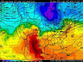
Take a look at the upper level temperature maps below. Unfortunately, the warm weather won't last forever for those who are enjoying this. Cooler weather isn't that far away, so enjoy the last little bit of the 70s while you can. Note the blob of orange and yellow over the Upper Midwest/Great Lakes and even into the southern reaches of the Hudson Bay. I bet if you had family or friends up that way, they'd be in awe of the weather as of late, let me know if you have any family or friends up that way anyway... that's got to be quite a place to live, yea?
It Won't Last Forever
Wow, look at the big difference in colors by the 17th of October. Like always, cold air begins to push out of the Polar regions and drops south of the international border. We're not talking bitter cold stuff yet as the cold air has yet to really establish itself near Santa's Workshop, but the deeper blues and hints of purple are starting to show up after the halfway point of the month.
Thanks for checking, have a great weekend!
Todd Nelson


No comments:
Post a Comment