14 F. high today, coldest since February 26, when the high in the Twin Cities was 8 F.
March 2: last subzero low in the Twin Cities (-3 F).
Wednesday Records:
2.38" rain Wednesday in Baltimore, a new 24 hour rainfall record. Old record was 1.27" in 1976.
2.06" at Trenton, New Jersey
1.44" Mount Pocono, PA
1.72" Allentown, PA
1.52" Concord, New Hampshire
67.96" precipitation at Allentown, Pennsylvania so far in 2011, the wettest year on record. Old record: 67.69" in 1952.
A Wimpy Winter So Far:
City Average Snowfall by Dec 8 Snowfall Received
Buffalo 13 inches 0.4 inches
Erie, PA 12 inches 0.9 inches
Cleveland 6.7 inches 1.1 inches
* Thanks to Chad Merrill from Earth Networks
"We have good reason to believe that what happened this year is not an anomaly, but instead is a harbinger of what is to come," NOAA Administrator Jane Lubchenco said in an interview. - from a Houston Chronicle article below on 2011's record number of extreme weather events.
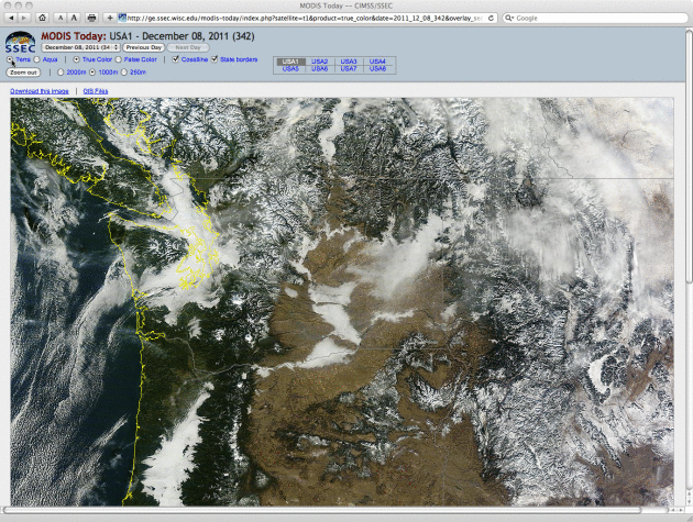
Stagnant Air Over Pacific Northwest. A persistent inversion (a layer of warm air on top of colder air near the ground) has resulted in a foggy, smoggy airmass for much of the Pacific Northwest in recent days - advisories posted for stagnant, polluted air. Satellite loop courtesy of NASA's MODIS.
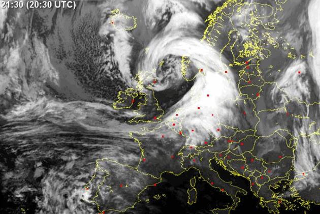
* Hurricane "Bawbag" slamming into Scotland? Read more here (at your own risk).
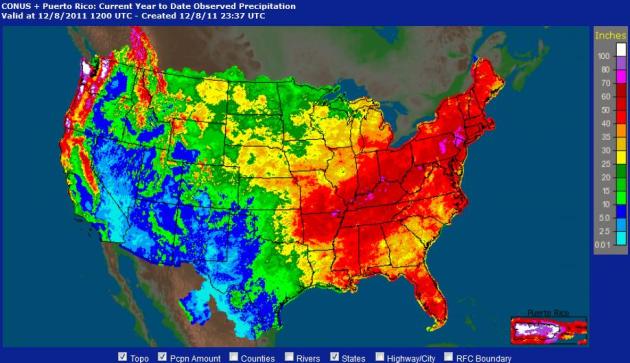
2011: A Very Soggy Year East Of The Mississippi. Here are Doppler radar rainfall estimates since January 1, courtesy of NOAA. A huge swatch from St. Louis and Little Rock to Pittsburgh, Washington D.C. and Boston has been soaked with over 60" - a few areas of 70"+ inch rainfall amounts from near Louisville to northern New Jersey.
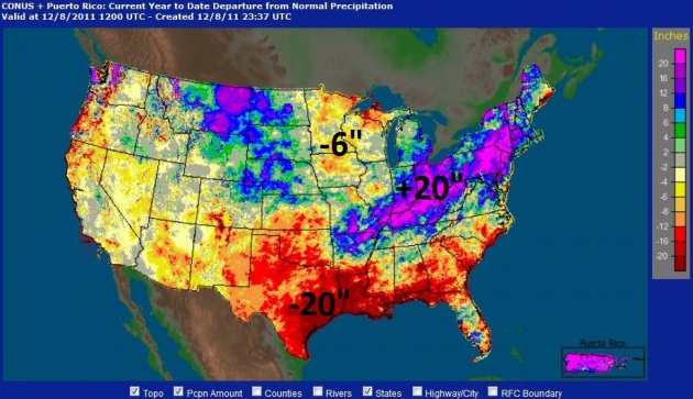
Departure From Normal. The same NOAA tool shows rainfall surpluses of over 20" from Montana to Columbus, Ohio to Scranton, PA. Meanwhile much of Texas, Louisiana and the Gulf Coast has experienced rainfall deficits of 20" or more. It really has been a tale of two different nations, in terms of rainfall amounts so far in 2011.
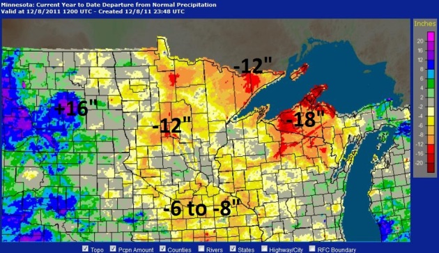
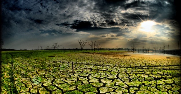
An Increasingly Dry Neighborhood. According to NOAA much of Minnesota is running a 6-8" rainfall deficit for the year, with pockets of 12" rainfall shortages (compared to normal) near Wadena and the Minnesoeta Arrowhead. Parts of northern Wisconsin and the U.P. of Michigan are also extremely dry, while the central Dakotas report an 8-16" rainfall surplus.
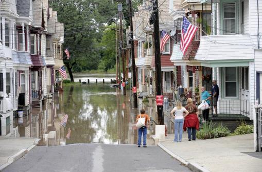
Photo credit: "In this Sept. 8, 2011 file photo, residents watch flood waters from the Mohawk River in Schenectady, N.Y. from Hurricane Irene. America's wild weather year has hit yet another new high: a devastating dozen billion-dollar catastrophes. The National Oceanic and Atmospheric Administration announced Wednesday that it has recalculated the number of weather disasters passing the billion dollar mark, with two new ones, pushing 2011's total to 12. The two costly additions are the Texas, New Mexico and Arizona wildfires and the mid June tornadoes and severe weather (AP Photo/Hans Pennink, File)"
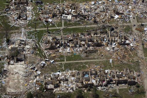
Photo credit: "In this May 7, 2011 aerial file photo, tornado damage is seen in Tuscaloosa, Ala. America's wild weather year has hit yet another new high: a devastating dozen billion-dollar catastrophes. The National Oceanic and Atmospheric Administration announced Wednesday that it has recalculated the number of weather disasters passing the billion dollar mark, with two new ones, pushing 2011's total to 12. The two costly additions are the Texas, New Mexico and Arizona wildfires and the mid June tornadoes and severe weather. (AP Photo/Dave Martin, File)"
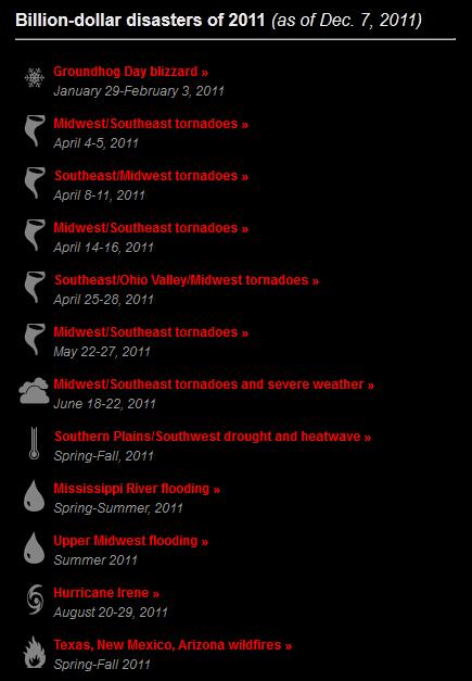
Billion-Dollar Disaster Update
- To date, the United States set a record with 12 separate billion dollar weather/climate disasters in 2011, with an aggregate damage total of approximately $52 billion. This record year breaks the previous record of nine billion-dollar weather/climate disasters in one year, which occurred in 2008.
- These twelve disasters alone resulted in the tragic loss of 646 lives, with the National Weather Service reporting over 1,000 deaths across all weather categories for the year.
- Previously only 10 events were reported; the two new billion-dollar weather and climate events added to the 2011 total include:
- The Texas, New Mexico, Arizona wildfires event, now exceeding $1 billion, had been previously accounted for in the larger Southern Plains drought and heatwave event. This is in line with how NOAA has traditionally accounted for large wildfire events as separate events.
- The June 18-22 Midwest/Southeast Tornadoes and Severe Weather event, which just recently exceeded the $1 billion threshold

Plane Has Combative Attitude Toward Storms. Hurricane Hunter turboprops aren't the only aircraft investigating storms, as the American Meteorological Society explains in their "Front Page" blog: "Technological advancements don’t always involve brand-new applications; sometimes, progress can be made when older technology is utilized in new ways. Such is the case with aircraft used for scientific research. “Experienced” military aircraft have proven to be effective for many types of atmospheric studies, and with the news (subscription required) that a powerful combat plane used by the military for many years is to be reconfigured and given a new assignment, many are looking forward to even greater research capabilities. Originally developed in the 1970s, the Fairchild Republic A-10 Thunderbolt II, better known as the “Warthog” or just “Hog,” is a twin-engine jet designed for close air support of ground forces. Now it’s being prepared to take on powerful storms."
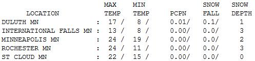

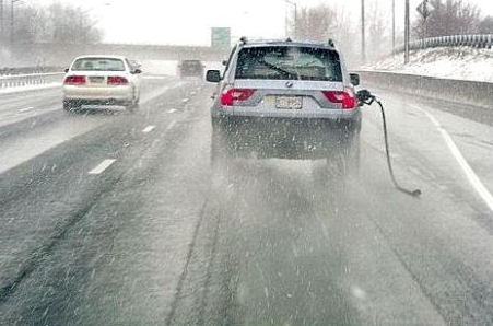
Reinforcing Cold Front. It's a strange December alright: Rochester has more snow on the ground than Duluth. The high temperatures above were mostly recorded around midnight, readings falling through the teens during the day under a brilliant blue sky. Yep, it felt like late January out there - temperatures bottom out today.

Paul's Conservation Minnesota Outlook for the Twin Cities and all of Minnesota:
TODAY: Numbing start, bright sun. Winds: W 10-15. High: 14 (wind chills from 0 to 5 above much of the day).
FRIDAY NIGHT: Mostly clear, still very cold. Low: 8
SATURDAY: Sun through high clouds, breezy - not as cold. High: 29
SUNDAY: Much-needed thaw. Plenty of sun, dripping icicles. Low: 21. High: 36
MONDAY: Mostly cloudy, few flurries possible. Low: 25. High: 34
TUESDAY: More sun, no weather worries. Low: 20. High: near 30
WEDNESDAY: Clouds increase, rain/snow mix late? Low: 19. High: 32
THURSDAY: Any wet snow quickly tapers. Low: 21. High: 28
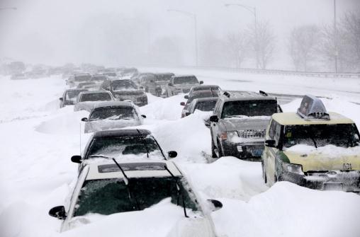
Snowmageddon Memories
Be honest. A year ago many of you probably thought I had taken leave of my senses. A one-way ticket to Crazy Town. "Paul's predicting 15-20" for the metro. Is he off his meds again?" It was a bold and potentially reckless forecast. For the next 48 hours I held my breath, staring at computer models until I was cross-eyed. I was WAY out on a limb.
I was accused of "hyping the weather"; a local radio DJ called me a weather terrorist. Really? I've been called worse. Predicting big storms is like getting undressed - in public. A total of 17.3" snow fell from Dec. 9-11. December 2010 saw 33.6" snow at MSP.
December often sets the tone for the entire winter. We were in a snowy groove last year; an ideal storm track from Des Moines to La Crosse to Eau Claire offering up a perfect balance of Arctic air and moisture from the Gulf.
This year a weaker La Nina may push the storm track farther south. It may be too cold for a repeat of last winter. We'll see.
The usually-reliable European ECMWF model brings a potential snow event into Minnesota next Wednesday/Thursday.
Short-term, plan on a dry, sunny sky with a warming trend; mid 30s Sunday. "Snowmageddon, The Sequel" is nowhere in sight.
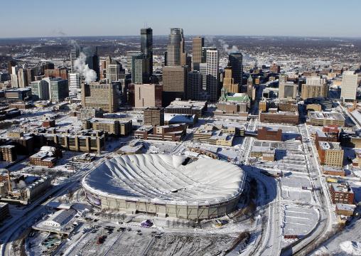
* photo credit above: "The Metrodome roof collapsed in December under the weight of heavy snow." Photo courtesy of Carlos Gonzales at the Star Tribune.
Paleoclimate Record Points Toward Potential Rapid Climate Changes. NASA has the story: "New research into the Earth's paleoclimate history by NASA's Goddard Institute for Space Studies director James E. Hansen suggests the potential for rapid climate changes this century, including multiple meters of sea level rise, if global warming is not abated. By looking at how the Earth's climate responded to past natural changes, Hansen sought insight into a fundamental question raised by ongoing human-caused climate change: "What is the dangerous level of global warming?" Some international leaders have suggested a goal of limiting warming to 2 degrees Celsius from pre-industrial times in order to avert catastrophic change. But Hansen said at a press briefing at a meeting of the American Geophysical Union in San Francisco on Tues, Dec. 6, that warming of 2 degrees Celsius would lead to drastic changes, such as significant ice sheet loss in Greenland and Antarctica."
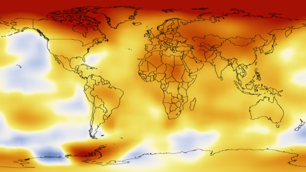
Photo credit above: "At the Earth’s current rate of carbon dioxide increases in the atmosphere, the planet is likely to experience several degrees increase in average temperatures and large-scale changes such as ice sheet loss that could lead to several meters of sea level rise this century, NASA’s James E. Hansen said in a recent paper. Credit: NASA’s Scientific Visualization Studio."
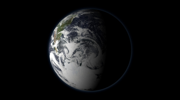
2010: Tied For Warmest Year Worldwide. More from NASA: "The average global surface temperature of Earth has risen by .8 degrees Celsius since 1880, and is now increasing at a rate of about .1 degree Celsius per decade. This image shows how 2010 temperatures compare to average temperatures from a baseline period of 1951-1980, as analyzed by scientists at NASA’s Goddard Institute for Space Studies. Credit: NASA GISS"
What's Behind Global Warming? Study Offers Concrete Answers To Earth's Changing Climates. The story from the Alaska Dispatch: "In case you haven't gotten the memo yet, Earth's climate has been changing, with the atmosphere slowly warming over the past six decades by almost 1 degree Fahrenheit. Many scientists say this small rise in the planet's annual temperature is only the beginning of a multi-decade sizzle that could ultimately lead to loss of summer sea ice, rising ocean levels, thawing permafrost, disrupted ecosystems -- plus more violent storms, droughts and heat waves. So what's behind the simmer? The industrial activities of modern life? Searing solar rays? Drunken wobbling by the globe on its axis? New calculations by two Swiss climate scientists say we can blame 74 percent of the warming over the past 60 years on human activities -- with the release of massive quantities of greenhouse gases like carbon dioxide as the main driver.
No comments:
Post a Comment