29 F. average high for December 9.
-27 F. record low at KMSP (1876)
38 F. predicted high for Sunday.
Boston: Friday was the 15th day/row of above-average temperatures.
"America now produces five times as much wind power than in 2004, with states like Colorado and Texas leading the nation. With states like New Jersey and California at the forefront, we have eight times more solar power as we did just seven years ago." - from a Huffington Post article on climate change below.

"Severe Cool." WeatherNation meteorologist Todd Nelson woke up to a brisk 2.8 F. at St. Michael Friday morning.

Frozen In Time. Here's a memorable pic, courtesy of the Grand Marais Facebook Page: "Lunch hour on the harbor today. After yesterday's wind and last night's temps, Artist's Point is "frozen in time".
Countdown To Christmas: 15 days.
Weather Guestimate:
Christmas Eve: Possible clipper with an inch or 2 of snow? High: 33 F.
Christmas Day: Windy and colder with flurries giving way to sun. High: 26
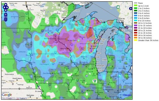
One Year Ago: Snowmageddon. December 11, 2010. Over 16" of snow, a total of nearly 17.5" from December 9-11. The National Weather Service in Chanhassen has a good recap of the storm here. A few highlights:
- The 22.0 inches ranks as the highest amount of snow on a calendar day on record for Eau Claire.
- With 17.1 inches, this snow event was the fifth largest snow storm on record for the Twin Cities, and the largest since the "Halloween Snow Storm" of Oct 31-Nov 2, 1991.
- This event ranked as the largest December snowfall on record for the Twin Cities, surpassing the 16.5 inches on Dec. 27-28, 1982.
- After this event, the seasonal snowfall of 34.0 inches in Minneapolis ranked as the 3rd highest snowfall through December 13th on record.
Next Week: Not As Cold - Closer To "Average". Our early taste of January won't hold - a more typical (zonal) flow returns next week, air originating over the Pacific instead of the Yukon. That should be good for highs in the upper 20s to upper 30s, a few degrees above average for a change.
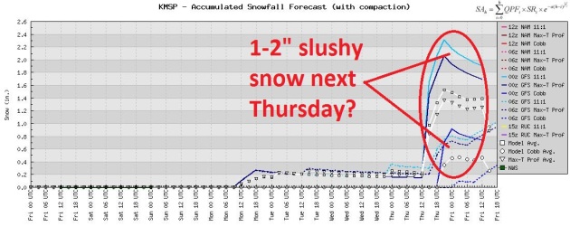
Plows Optional Until Further Notice. Models are hinting at a rain snow mix from late next Wednesday into Thursday, temperatures aloft warm enough for a mix of rain, sleet, then snow (in that order). It's still early to be speculating about amounts - but in spite of the fact that this is a southern system, laden with moisture from the Gulf of Mexico, it will move quickly, and temperatures aloft should be warm enough for a slushy mix, which will ultimately keep final amounts down. A few inches of sloppy snow, especially north/west of the Twin Cities? Possibly. Snowmageddon Part II? No. I don't think so.
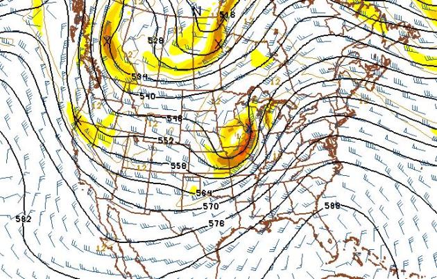
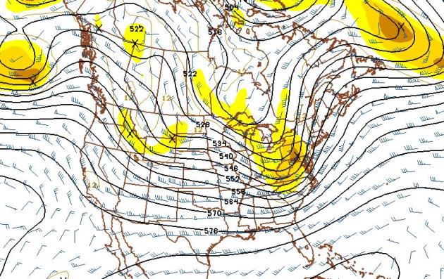
Possibly The ONLY Chance Of Additional Snow Between Now And Christmas. The 500 mb GFS forecast for next Thursday shows a fast-moving trough of low pressure, an embedded wrinkle of cold air aloft, sliding off just to our south and east, on a track which might be favorable for accumulating snow close to home. The only fly in the weather ointment: temperatures aloft may be just warm enough for precipitation to start as rain, keeping any snowfall amounts down. Again, it's early.
Christmas 2011 Preview. With a strong west/northwest wind flow aloft I'm expecting colder than average conditions, a lot of wind, the possibility of a few flurries, but conditions don't favor any major storms right around Christmas, not over the Upper Midwest. A trough of low pressure may spin up rain, snow and ice for portions of New England Christmas Eve. If you're traveling keep checking back for updates.
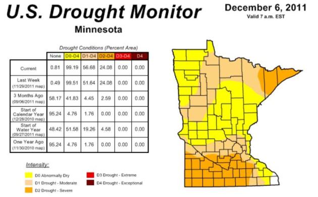
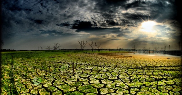
Deepening Drought. Here's the latest Drought Monitor update from NOAA, showing that 56.68% of Minnesota is experiencing either moderate or severe drought - up from 4.45% just 3 months ago. For much of Minnesota this will have been the driest autumn on record, and my hunch is that this dry spell will spill over into much of December, possibly January as well.
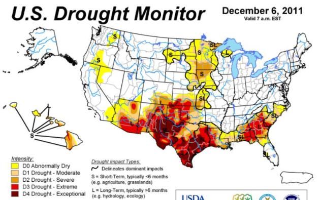
National Drought Overview. Many residents of Texas were probably praying for a hurricane or a tropical storm a few months ago - but no such luck. The worst drought in 117 years of record-keeping continues to worsen. Lakes and reservoirs are vanishing, many towns are running out of water. Click here to see a national update from NOAA.
City Average Snowfall by Dec 8 Snowfall Received
Buffalo 13 inches 0.4 inches
Erie, PA 12 inches 0.9 inches
Cleveland 6.7 inches 1.1 inches
* Thanks to Chad Merrill from Earth Networks
"We have good reason to believe that what happened this year is not an anomaly, but instead is a harbinger of what is to come," NOAA Administrator Jane Lubchenco said in an interview. - from a Houston Chronicle article below on 2011's record number of extreme weather events.
* Hurricane "Bawbag" slamming into Scotland? Read more here (at your own risk).
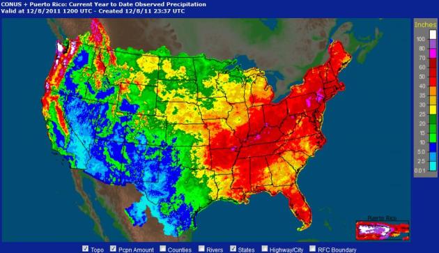
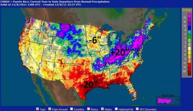
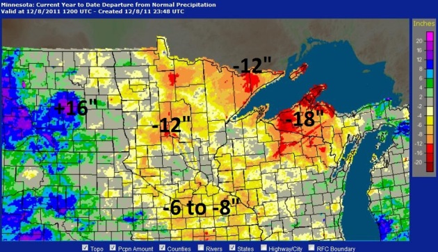
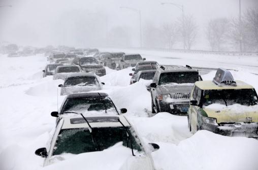
Photo credit: "In this Sept. 8, 2011 file photo, residents watch flood waters from the Mohawk River in Schenectady, N.Y. from Hurricane Irene. America's wild weather year has hit yet another new high: a devastating dozen billion-dollar catastrophes. The National Oceanic and Atmospheric Administration announced Wednesday that it has recalculated the number of weather disasters passing the billion dollar mark, with two new ones, pushing 2011's total to 12. The two costly additions are the Texas, New Mexico and Arizona wildfires and the mid June tornadoes and severe weather (AP Photo/Hans Pennink, File)"
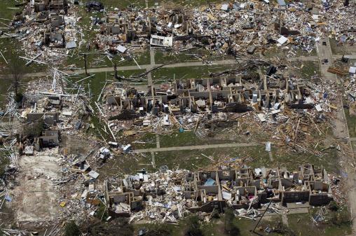
Photo credit: "In this May 7, 2011 aerial file photo, tornado damage is seen in Tuscaloosa, Ala. America's wild weather year has hit yet another new high: a devastating dozen billion-dollar catastrophes. The National Oceanic and Atmospheric Administration announced Wednesday that it has recalculated the number of weather disasters passing the billion dollar mark, with two new ones, pushing 2011's total to 12. The two costly additions are the Texas, New Mexico and Arizona wildfires and the mid June tornadoes and severe weather. (AP Photo/Dave Martin, File)"
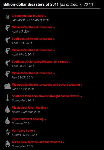
Billion-Dollar Disaster Update
- To date, the United States set a record with 12 separate billion dollar weather/climate disasters in 2011, with an aggregate damage total of approximately $52 billion. This record year breaks the previous record of nine billion-dollar weather/climate disasters in one year, which occurred in 2008.
- These twelve disasters alone resulted in the tragic loss of 646 lives, with the National Weather Service reporting over 1,000 deaths across all weather categories for the year.
- Previously only 10 events were reported; the two new billion-dollar weather and climate events added to the 2011 total include:
- The Texas, New Mexico, Arizona wildfires event, now exceeding $1 billion, had been previously accounted for in the larger Southern Plains drought and heatwave event. This is in line with how NOAA has traditionally accounted for large wildfire events as separate events.
- The June 18-22 Midwest/Southeast Tornadoes and Severe Weather event, which just recently exceeded the $1 billion threshold
Tropical Storms May Be Triggering Earthquakes. I know, seems like a stretch to me, too. But follow the logic. Here's an excerpt from scienceagogo.com: "University of Miami scientist Shimon Wdowinski (pictured) says that earthquakes - including the recent seismic events in Haiti and Taiwan - may be triggered by severe tropical storms (cyclones, hurricanes and typhoons). Wdowinski is presenting his, er, groundbreaking study at the 2011 American Geophysical Union Fall Meeting, in San Francisco. "Very wet rain events are the trigger", explained Wdowinski, an associate research professor of marine geology and geophysics."


Top 10 Things You Can't Have For Christmas. For sheer decadence, nothing quite matches gizmag.com's Top 10 Wish List for Christmas 2011. This takes WOW to a whole new level for people with more money than sense: "With Christmas fast approaching it means it's time for our annual look back at some of the technology that caught our eye and had us wishing our fortunes didn't match that of the Greek economy. While not all of the items on this list can be had for an extremely large wad of cash, those that are available for purchase will only find their way down the chimneys of those with a lottery winning or ultra-wealthy - and ultra-generous - family member or friend. Still, Christmas is a time for miracles so it is in that spirit that Gizmag presents its 2010 top 10 list of things you can't have for Christmas this year."

Apple's iPhone App Of The Year? That great honor belongs to "Instagram", which is pretty cool, I have to admit. Now any mediocre photographer can make their shots look like art. Bad art. More from Huffington Post: "Apple has released its annual iTunes Rewind, a look back at the most popular content available in the App Store over the past year. This year, top honors went to photo-sharing app Instagram, which Apple named "iPhone App of the Year." As Apple's reigning favorite, the app will be featured prominently in the App Store and is likely to see a significant surge in downloads. Instagram lets you shoot photos, apply polaroid-like filters and share your creations on Facebook, Twitter, Tumblr and other popular social networks. Its attractive interface and ease-of-use has earned the iOS app between 14 million and 15 million downloads, according to figures listed by Instagram CEO Chief Executive Kevin Systrom at Thursday's LeWeb conference in Paris. CNET reports that Systrom also said two developers are currently working on an Android version of the app."

Great Stocking-Stuffer Suggestion: "For Love Of Lakes". If you love Minnesota's lakes as much as I do, then you need to run out and buy this book. Author Darby Nelson manages to capture the magic of lake culture. The book is full of photos, quotes, fun facts - it reads like poetry.
Support Conservation Minnesota's efforts; for a $50 donation you automatically get the book.
A link directly to Amazon is here.

Quick Facts for Paul Douglas
From For Love of Lakes by Darby Nelson
1. We say we love our lakes but we not only allow but participate in their deterioration. What kind of love is that? [Thesis of the book.]
2. A lake doesn’t begin and end at the edge of its shores. It begins at the edge of its watershed.
3. Thank those dragonflies at the lake. They eat skeeters that otherwise would nibble you.
4. By helping keep lakes clear (by filtering algae), the tiny waterfleas help retain lake property values.
5. What is the main source of excess phosphorus entering Thoreau’s famous Walden Pond? Swimmers’ pee. (Walden has 700,000 visitors a year.)
6. Some species of blue-green algae can be poison for dogs and other land animals.
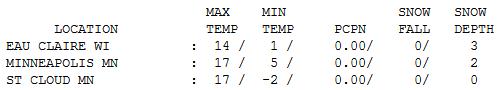

An Early January. Temperatures were 10-15 degrees colder than average, statewide - daytime highs ranging from 14 at Eau Claire and Alexandria to 17 at St. Cloud and the Twin Cities, 19 at Redwood Falls. St. Cloud got off to a subzero start, waking up to -2 F.

Paul's Conservation Minnesota Outlook for the Twin Cities and all of Minnesota:
TODAY: Bitter start, partly sunny, turning milder. Winds: S 10. High: 28
SATURDAY NIGHT: Partly cloudy, not as Nanook. Low: 21
SUNDAY: Plenty of sun, a welcome thaw! High: 38
MONDAY: More clouds, few flurries possible. Low: 26. High: 34
TUESDAY: Intervals of sun, no complaints. Low: 22. High: 32
WEDNESDAY: Clouds increase. Cold rain late? Low: 23. High: 35
THURSDAY: Rain/snow mix gradually tapers - potential for a little slush, especially northern/western MN. Low: 27. High: 33
FRIDAY: Windy and colder, few flurries. Low: 16. High: 25
Quiet Thru Christmas?
"We have good reason to believe that what happened this year is not an anomaly, but instead is a harbinger of what is to come," NOAA Administrator Jane Lubchenco said in a recent interview. 2011 was a year to remember, meteorologically. 12 separate billion dollar weather disasters; a new record. The Texas drought was the most intense in 117 years of record keeping, and 199 tornadoes touched down on one day, April 27; another record. Over 1,000 weather-related deaths, in spite of Doppler radar, smartphone apps and alerts and heightened awareness. Welcome to the "new normal".
Minnesota's drought will probably get worse before improving sometime in 2012 - much of southern Minnesota is running a 5 to 10 inch rainfall deficit. According to the Drought Monitor 56% of the Gopher State is in a moderate or severe drought, up from 4% just 3 months ago.
I still don't see any significant storms between now and Christmas. A fast-moving southern system may push a rain-snow mix into town by next Wednesday/Thursday; can't get excited about amounts.
Good news: you're about to regain some feeling in your toes. 34-38 F Sunday and Monday will feel like a vacation (from January). Hooray!

Biggest Polluters Hold Up Deal At UN Global Warming Talks. Bloomberg Business has the details: "Dec. 9 (Bloomberg) -- China, the U.S. and India, the three biggest polluters, maintained resistance to a time line leading to the next agreement on global warming, threatening efforts to keep alive the only limits on fossil fuel emissions. European Union Climate Commissioner Connie Hedegaard said she hasn’t yet won backing for her demand for a “road map” pointing to the next climate agreement because some nations are holding back support. She indicated that China and India remained a block. Last night, the U.S. said it won’t agree to begin talks for a legally-binding deal."

In The Wake Of Durban And The Hottest Decade On Record: The Way Forward On Global Warming. Here's an informative, upbeat story from the Huffington Post: "America now produces five times as much wind power than in 2004, with states like Colorado and Texas leading the nation. With states like New Jersey and California at the forefront, we have eight times more solar power as we did just seven years ago. Cars sold in 2009 were the most fuel-efficient and least polluting in history, thanks to fuel economy standards adopted by the Obama Administration and built on the foundation of 14 states' Clean Cars standards. Plug-in cars are coming off the assembly line in Michigan. Energy savings from utility energy efficiency programs have nearly tripled since 2004. Transit ridership has steadily grown 10 percent since 2004 with ridership in places like metropolitan Phoenix doubling in that period. And, terms like "green buildings" and "sustainability" -- virtually unheard of a decade ago -- have now become part of the common vocabulary." Photo above courtesy of Times of India.

Business Won't Solve Global Warming. An article from the Sacramento Bee: "The climate summit in Durban, South Africa, does not appear to be making great strides. The United States is dragging its feet, blocking any binding agreement to reduce greenhouse gases. Along with Washington, businesses are trying to turn the whole Durban process away from urgent emissions cuts and toward an increasingly perplexing and sophisticated array of non-solutions. These include large-scale biofuel plantations, genetically engineered "supercrops," synthetic biology, unworkable yet lucrative carbon offset schemes and something called geoengineering, whereby scientists would turn the globe into a giant experiment by injecting newfangled materials into the atmosphere to try to counteract global warming."
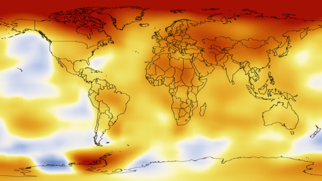
Photo credit above: "At the Earth’s current rate of carbon dioxide increases in the atmosphere, the planet is likely to experience several degrees increase in average temperatures and large-scale changes such as ice sheet loss that could lead to several meters of sea level rise this century, NASA’s James E. Hansen said in a recent paper. Credit: NASA’s Scientific Visualization Studio."
No comments:
Post a Comment