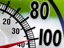
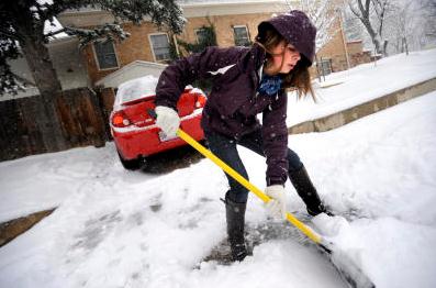
30 F. - average high for December 6.
7.9" snow so far this winter season. Average (to date) is 12.3"
3" snow on the ground at KMSP.
No significant snow/ice/rain in sight for Minnesota, at least through the end of next week.

Could heavy snowcover over Siberia in October be a signal for what kind of winter much of the east coast will experience months later? An article in the Washington Post from the Capital Weather Gang's Andrew Freedman below.
A laser capable of taking 12,000 snow measurements a second? Details below.
"2011 is tied for the 10th-hottest year since records began in 1850, the office said in its annual assessment of average global temperatures. Arctic sea ice has also shrunk to record-low volumes this year, it said. The 13 hottest years on the books all have occurred in the last 15 years." - USA Today article below.
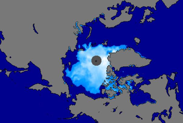
"According to the Report Card, the five deepest summer meltbacks in sea ice in the satellite record, which extends back to 1979, all occurred during the past five years. In 2011, sea ice extent at the end of the melt season was the second-lowest on record, while sea ice volume (that is the ice’s extent times its average thickness) set a new record low." - excerpt from a story at The Current.
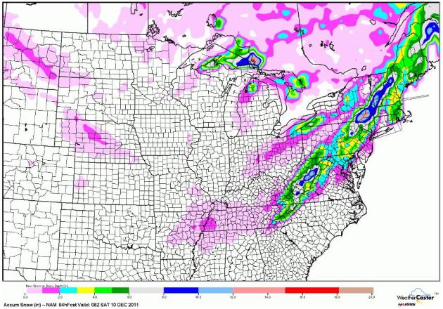
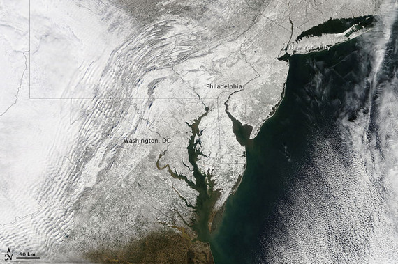
Predicted Snowfall. Here is the latest NAM solution, valid through midnight Friday night. Rain will end as a potentially plowable accumulation over the Appalachians, a few inches from Harrisburg, York and Philadelphia to the suburbs of Boston by Thursday.
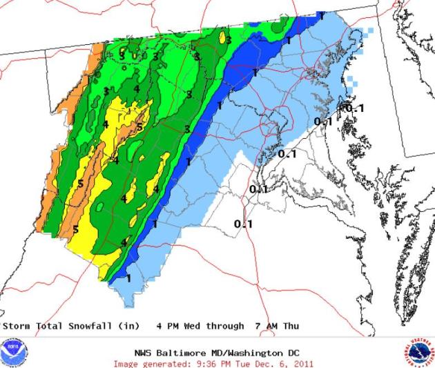
Heavy Snow Potential Out East. According to the DC office of the National Weather Service, little more than a coating of slush is likely for D.C. and Baltimore, but some 4-6" amounts are expected over the hills of far western Maryland, Virginia and West Virginia.
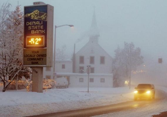
America's 25 Coldest Cities. Where do you think the Twin Cities rank on this dubious list? Yes - we definitely made the list. At least we're not #1. That distinction goes to Fairbanks, Alaska. North Dakota has 3 cities on the list and Duluth cracked the Top 10! Check out the full article (slide show) from The Daily Beast:
#1, Fairbanks, Alaska
The Siberia To East Coast Snow Connection. The Washington Post's Capital Weather Gang has a fascinating story about possible "atmospheric linkage". Specifically, a local researcher has found a possible correlation between snowcover over Siberia in October and the severity of the winter to come, especially major eastern cities across the USA: According to new research, Washingtonians shouldn’t blame bad luck for the recent string of high-impact snowstorms, from “Snowmaggedon” two years ago to last January’s “Commuteageddon.” Instead, it may be more justified to cast a suspicious gaze toward Siberia, about 6,000 miles away. Famous for its bone-chilling cold, Siberia typically starts building a snow pack during October, and the speed of its transition from tundra to snowscape helps to shape winter weather throughout much of the Northern Hemisphere according to a new study... Cohen’s study unveils a new index, called the Snow Advance Index (SAI), that skillfully predicts the phase of the coming winter’s Arctic Oscillation (AO), based on the growth of Siberia’s October snow cover. Historically, he reports, the index has explained “close to 75%” of the AO variability."
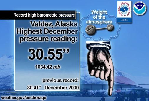
Under Pressure! More details on the record high pressure for Alaska, courtesy of the National Weather Service: “Under pressure? The extreme weight of the air over South-Central Alaska pushed barometers in the Northern Gulf of Alaska and Prince William Sound region to all-time December records today. Homer tied the December benchmark at 30.46″. Kodiak reached 30.50″ (previous record: 30.41″, December 2000). Valdez set a new December record at 30.55″ (previous record: 30.41″ December 2000)."
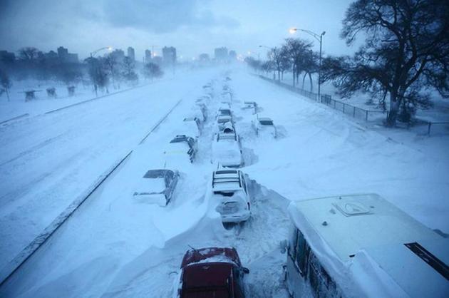
But how much more than that may accumulate is impossible to say -- and it depends on precisely how the coming season’s winter storms move, and on which tracks they follow. One could also reasonably argue that since 13 of the 18 comparably low-yielding snow seasons on record through Dec. 1 over the past 127 years have gone on to produce sub-normal final winter snow tallies, that there’s NO guarantee the coming season will be a mammoth snow-producer. " (photo above of February's "Snowpocalypse" in Chicago courtesy of chicagotribune.com).

NCAR Scientists Work To Glean Weather Data From Cars. Here's another fascinating article from The Daily Camera that I thought had some merit: "Scientists in Boulder are beginning to tap into a vast reservoir of weather data from an unlikely source -- automobiles. Some of the data are straightforward, such as the temperature observations recorded by onboard computers in most new passenger vehicles. But other information is subtler. Researchers at the National Center for Atmospheric Research are also interested in when drivers turn on their windshield wipers, if headlights are flipped on during daylight hours and when a vehicle's antilock brake system engages."
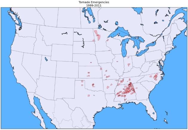
Tornado Emergencies Since 1999. Here's an interesting entry from Dr. Patrick Marsh at the University of Oklahoma. Notice the concentration over the Deep South, "Dixie Alley", and the fact that Minnesota has seen more tornado emergencies (confirmed tornado on the ground moving toward a populated area) than the Dakotas, Iowa and Wisconsin: "(Above) is a map of all tornado emergencies issued since 1999. Keeping with my definition of a tornado emergency, the polygons plotted are the polygon described by the “LAT…LON” tag at the bottom of either a) the first severe weather statement (SVS) that contained the “Tornado Emergency” phrase, or, no “LAT…LON” tag was present in the SVS, b) the parent tornado warning (TOR). If the “LAT…LON” tag was not present in either the SVS or the TOR, I used the county listed in the original TOR. This only happens 3 times: Ochiltree County, TX (2000); Johnson and Marion County, IN (2002); and Hancock County, IN (2002)."
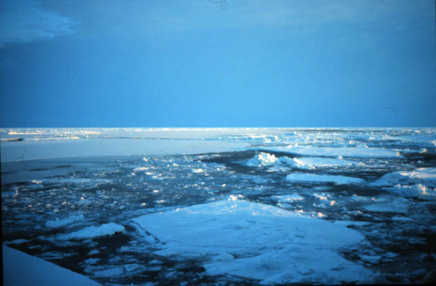
Arctic Settles Into New Phase: Warmer, Greener And Less Ice. NOAA has the story: "An international team of scientists who monitor the rapid changes in the Earth’s northern polar region say that the Arctic is entering a new state – one with warmer air and water temperatures, less summer sea ice and snow cover, and a changed ocean chemistry. This shift is also causing changes in the region’s life, both on land and in the sea, including less habitat for polar bears and walruses, but increased access to feeding areas for whales. Changes to the Arctic are chronicled annually in the Arctic Report Card, which was released today. The report is prepared by an international team of scientists from 14 different countries."
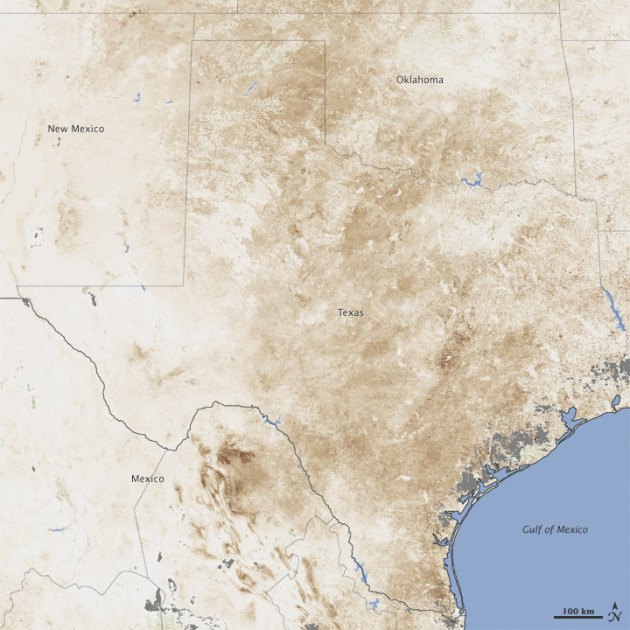
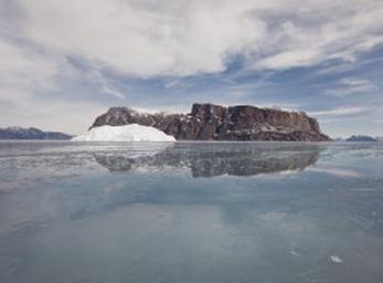
NASA Satellites Show Texas Aquifers At Record Lows. AP and ABC News has the story: "A historic drought has depleted Texas aquifers to lows rarely seen since 1948, and it could take months — or even years — for the groundwater supplies to fully recharge, scientists who study NASA satellite data said Wednesday. Climatologists, hydrologists and even local residents had suspected the drought that has parched Texas for 14 months was significantly hurting the precious aquifers that course beneath the Lone Star State. Data compiled by NASA satellites combined with information from the University of Nebraska's National Drought Mitigation Center confirm those fears." (photo above courtesy of NASA's Earth Observatory).
Large Payouts From Natural Disasters Could Lead To Auto Rate Insurance Increases. Metrowest Daily News has the story: "From earthquakes, fire and floods to tornadoes and tropical storms, the natural disasters that hit the nation this year broke records for the billions of dollars in damage they wreaked. And while catastrophic weather events cost many consumers their homes, cars and businesses, damaged property can be replaced - provided it is insured. But for the insurance providers who must make good on those policies, weather-related catastrophes translated into billions of dollars in losses for which there is no reimbursement. Insurers are in the business of calculating risk, and with storms and other severe weather taking ever-greater bites out of company profits, experts say it is only logical to expect insurers to seek an increase in revenues to keep pace with skyrocketing catastrophe losses."


Paul's Conservation Minnesota Outlook for the Twin Cities and all of Minnesota:
TODAY: Some sun through high clouds. Clipper arrives "dry". Winds: NW 10-15. High: 27
WEDNESDAY NIGHT: Patchy clouds, turning gusty and colder again. Low: 12
THURSDAY: At least the sun is out. Brisk - a numbing breeze! High: 20 (teens most of the day).
FRIDAY: Sunny, premature taste of January. Low: 4. High: 16
SATURDAY: Breezy with plenty of sun - not quite as Nanook. Low: 6. High: 27
SUNDAY: Welcome thaw. No travel problems with a mix of clouds and sun. Low: 19. High: 34
MONDAY: More clouds, few flurries. Low: 24. High: 33
TUESDAY: Clouds increase during the day. Low: 26. High: 32
Yep, It's Cold Enough
Forget the calendar on the wall - "meteorological winter" is already here. Staring at my shriveled back yard thermometer it's not hard to believe. If you look at what is historically the 90 coldest days of the year (and who among us hasn't) winter really kicks off closer to December 1 than December 21.
7.8" snow so far this winter season in the Twin Cities; we should have seen about 12" so far. I still think El Nino will spark colder than average temperatures into February, and that old adage "too cold to snow" rings partially true. If it's 10-15 F or colder it usually means the main storm track has been pushed too far south of Minnesota for massive snowfalls. I suspect the main storm track may run from Des Moines to Milwaukee and Chicago much of winter, a parade of storms "brushing" us with snow.
According to WGN's Tom Skilling in Chicago: 13 of 18 "low-yielding" snow seasons on record through Dec. 1 since 1884 have gone on to produce sub-normal final winter snow tallies.
Too early to write off big snowfalls, especially February and March.
The GFS hints at a sloppy mix the middle of next week; other models keep us dry through Christmas. Santa's not worried... yet.
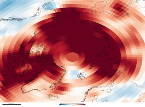
Warming Has Pushed Arctic To "New Normal". The Current has the story: "Since 2006, the Arctic has been less Arctic — warmer, and with less snow and ice than the region used to have — according to the latest comprehensive analysis of the Arctic environment released today by the National Oceanic and Atmospheric Administration (NOAA). This doesn’t come as a huge surprise. Scientists have long expected that greenhouse gases would warm the Far North up faster than other parts of the globe since various feedback cycles unique to the Arctic can magnify relatively small temperature changes (melting ice and snow, for example, let exposed land and water absorb more of the Sun’s heat, which melts more ice and snow, and so on). This “Arctic amplification” is one reason why the polar bear, which relies on sea ice for survival, has been the enduring symbol of global warming activism. This past year (October 2010-September 2011), surface temperatures in the Arctic were 1.5 degrees Celsius warmer than average. The image above shows where average air temperatures were up to 3 degrees Celsius above (red) or below (blue) the long-term average (1981-2010). Credit: NOAA."
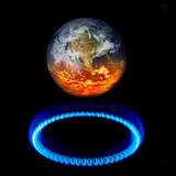
Warmest Decade Since 1850. The United Nations has the story: "New research from the World Meteorological Organization or WMO shows that 2011 has been the tenth warmest year since 1850. A report released by the organization on Tuesday added that global temperatures in 2011 have been higher than any other previous year with a La Nina event, an ocean atmosphere phenomenon which has a cooling influence. A 2.0 degree Centigrade rise in global temperature threshold was set at the World Conference in 2005, beyond which climate change is likely to be unstoppable. The report says with the increase in greenhouse gases, any rise above this threshold, which is rapidly approaching, could trigger drastic changes."

Two Degree Global Warming Limit Is Called A "Prescription For Disaster". Scientific American has the story: "A mantra that has driven global negotiations on carbon dioxide emissions for years has been that policy-makers must prevent warming of more than two degrees Celsius to prevent apocalyptic climate outcomes. And, two degrees has been a point of no return, a limit directly or indirectly agreed to by negotiators at International climate talks. James Hansen, director of the NASA Goddard Institute for Space Studies in New York, whose data since the 1980s has been central to setting that benchmark, said today that two degrees is too much. New, extensive study of the paleoclimate record going back 50 million years by Hansen and others now shows that the two-degree target for global temperature rise "is a prescription for disaster," Hansen said here at a news conference during the American Geophysical Union meeting."

Huntsman Tweaks Climate Change Tone; Says Scientists Need To Clarify Facts. And then there were none. Curious about which facts need further explanation: the 38% spike in man-made greenhouse gases? Maybe the fact that the hottest 13 years on the books have taken place in the last 15 years? Or the fact that many politicans (on both sides of the aisle) take money from major carbon-based polluters? So many inconvenient facts to sort out. MSNBC has the story: "Republican presidential candidate Jon Huntsman appeared to take a notably more skeptical view towards current climate change science Tuesday, saying that the "scientific community owes us more" on the issue and that not enough solid research exists to "formulate policies" based on global warming. "I'm not a scientist, I'm not a physicist, but I would defer to science in that discussion, and I would say that the scientific community owes us more in terms of a better description or explanation about what might lie beneath all of this," Huntsman told an audience of bloggers at the conservative Heritage Foundation in Washington."
U.N.: World Temperatures Maintain The Heat Of Global Warming. USA Today has more details: "DURBAN, South Africa – World temperatures keep rising, and are heading for a threshold that could lead to irreversible changes of the Earth, the United Nations weather office said Tuesday. 2011 is tied for the 10th-hottest year since records began in 1850, the office said in its annual assessment of average global temperatures. Arctic sea ice has also shrunk to record-low volumes this year, it said. The 13 hottest years on the books all have occurred in the last 15 years. "The science is solid and proves unequivocally that the world is warming," said R.D.J. Lengoasa, deputy director of the World Meteorological Organization, and human activity is a significant contributor."
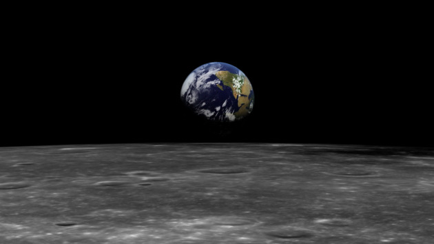
In Austere Times, World Needs A Climate Change "Plan B". Here's a timely Op-Ed from CNN: "As world leaders struggle to prevent the global economy tipping into further economic crisis, negotiators from 195 nations are in Durban, South Africa at the U.N. Climate Change Conference. They are working to avoid the far greater economic and social meltdown threatened by climate change. Whilst few dispute the serious risks climate change poses, there are legitimate concerns that the deal in discussion cannot be agreed, let alone effectively implemented. What's being discussed is a global deal involving binding commitments by wealthier nations to reduce carbon emissions. The deal also involves these nations footing a large part of the bill for financing action in poorer countries to reduce emissions and support communities hurt by climate change. Photo courtesy of Apollo 17 and NASA.
No comments:
Post a Comment