42 F. high on Christmas Day in the Twin Cities.
1999: last time we had a warmer Christmas (high was 43 F. that year).
Only 4 Christmas Days have been warmer since 1905 (
NWS records).
Yesterday was only the 3rd time since 1944 the mercury has climbed above 40 on Christmas Day in the Twin Cities.
20 F. high in the metro area Christmas last year.
25 F. average high at KMSP.
51 F. record high today (1936).
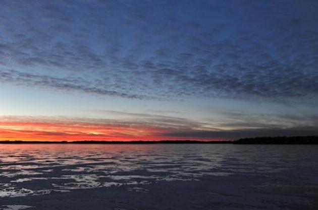
Remarkably Unsettling. Yes, a white Christmas would have been nice. 42 F. on Christmas Day could be considered a gift, a nice break from wind chill and slippery roads. Climate change? Not necessarily, although our mild, dry winter is consistent with climate science, and we have seen a trend toward milder winters, especially since the mid 90s. A deepening drought may be a bigger factor - the dry spell that began in August is obviously spilling over into at least the first half of winter. La Nina winter tend to be colder and snowier (exhibit A: last winter), but the sad truth: all La Nina events are different, and for some reason prevailing winds have been howling from Vancouver and Seattle - a mild, dry, almost October-like pattern. I'd be lying if I said I didn't enjoy yesterday on some level. But it was also strangely unsettling to be wandering the yard in a sweatshirt, grilling, triple-checking the calendar to make sure it really is late December.
"
So far today the official high temperature at both Rockford and Chicago has been 44F. This makes today the 10th warmest Christmas on record in Rockford (out of 106) and tied 14th place (out of 140) in Chicago! This is also the warmest Christmas in 17 years, not since 1994 has the region seen temps. this warm on Christmas. It is possible we may still climate a degree or two before peaking out this afternoon." - Chicago National Weather Service.
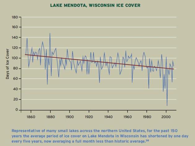
 1 month
: ice is on Lake Mendota, in Madison, Wisconsin, an average of 1 month less every winter than it was 150 years ago. Photo courtesy of the U. of Wisconsin. "
Lakes and rivers throughout the northern hemisphere are now freezing an average of six days later than they did 100 years ago." - from a recent
paper from the National Wildlife Fund, details below.
“
I’ve been a meteorologist 30 years and never seen a year that comes close to matching 2011 for the number of astounding, extreme weather events,” Jeffrey Masters, a co-founder of the popular Web site Weather Underground, said last month. “Looking back in the historical record, which goes back to the late 1800s, I can’t find anything that compares, either." - Weather Underground's Dr. Jeff Masters, in a New York Times article below.
Blizzard Of Wrapping Paper. Christmas is over, and I don't know about you, but I kept staring out the window yesterday, shaking my head in disbelief. Was it really December 25? On some level it felt more like Halloween than Christmas. Instead of shoveling I swept out the garage - took a walk (in a sweatshirt). I'd by lying if I said I didn't enjoy the lack of ice and wind chill ("no weather for Christmas") and yet, it didn't feel quite right either. Surreal. Unnatural. My Polaris snowmobiles are collecting dust - mocking me. One of these days I may even be able to fire them up. Until then I'll just stare at the maps, a bewildered spectator like everyone else. Welcome to the truncated, abbreviated, compressed, potentially fleeting "Winter" of 2011-2012.
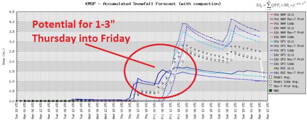
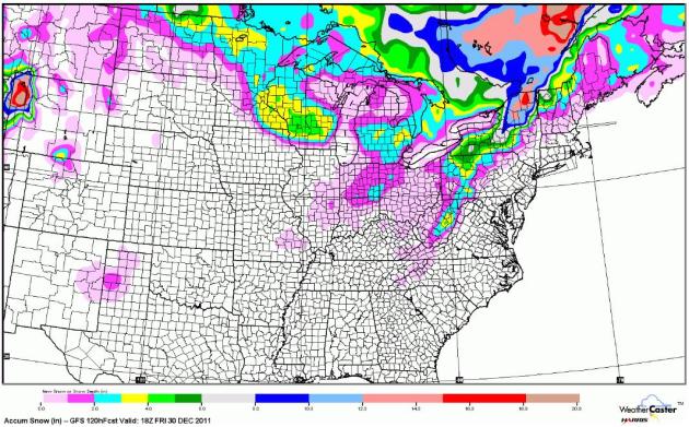
A White New Year's Eve? I want to see a few more computer model runs, but there's a growing opportunity for a few inches of snow from Thursday into Friday, a potentially "plowable" accumulation in or near the Twin Cities metro. With a little luck roads will be in better shape in time for New Year's Eve festivities and travel plans.
"Few Inches" By Late Week? It's way too early to panic (or celebrate) but there are some signs that it may actually "snow" here later this week, the best chance of some accumulating snow late Thursday into New Year's Eve - right now the GFS has the best chance of a couple inches south/east of the Twin Cities.
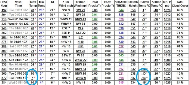 Signs Of The First (Real) Cold Front Of Winter
. It's not definite (it never is, come to think of it), but the GFS
is pulling the first numbing air of winter into town around January 10. Not biting, subzero cold, but we could see a few days with highs in the teens and low 20s. We're due.
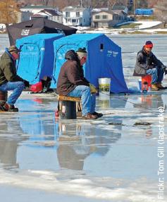
Outlook For Ice Fishing: More Uncertain Winters. Here's an excerpt from a recent paper, "
Oddball Winter Weather, Global Warming's Wake-Up Call For The Northern United States" (pdf), prepared by the National Wildlife Fund: "
On a given day in winter, lakes throughout the upper-Midwest and New England can be populated with hundreds of ice-fishing houses. In 2006, ice fishermen spent more than $100 million on equipment alone. However, global warming threatens this cherished pastime. Lakes and rivers throughout the northern hemisphere are now freezing an average of six days later than they did 100 years ago.36 Some lakes that tended to freeze completely in the winter now often remain at least partially open. Continued reductions in lake ice cover would reduce icefishing opportunities across the Great Lakes and New England, and increase risks to fishermen."
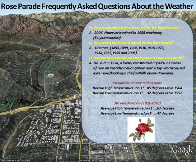
More Than You Ever Wanted To Know About The Rose Bowl Parade. From a meteorological perspective, that is. Graphic courtesy of the National Weather Service.
Ice-Covered Days On The Decline. Call me crazy, but I think I see a trend in the graph above. This is data for Lake Mendota in Madison, Wisconsin, showing a steady decrease in the number of days with ice since 1850. "
In the past 150 years the average period of ice cover on Lake Mendota, In Wisconsin, has shorted by 1 day ever 5 years, now average a full month less than historic average." Source: National Wildlife Fund
paper on odd winter weather.
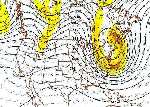
Major New England Storm In Early January? The 500mb forecast for January 3 shows a massive "cut-off low" over the northeast, a sprawling whirlpool of cold air capable of spinning up a major coastal storm for the northeast. Timing and amounts are still unclear, but if you're traveling to New York, Boston, or any other destination in New England around January 2-3 you'll want to stay up on the latest forecast.
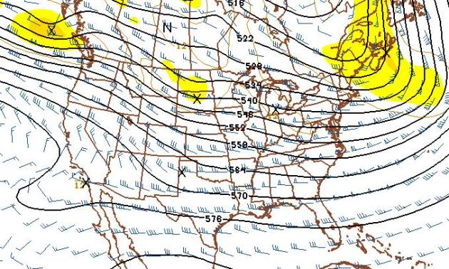
Waiting For The Other Shoe (Boot) To Drop. The sheer persistence of this zonal, west to east flow from the Pacific is impressive. I keep waiting for the jet stream to buckle, a full-latitude trough capable of yanking truly bitter, arctic air southward from the Arctic Circle. Looks like we'll be waiting a little while longer. The 500mb (18,000 foot) forecast for January 10 continues to show the upper level steering winds howling from Seattle and Vancouver, meaning mild and dry - highs poking into the 30s through the first week of January. At some point (statistically) it HAS to get colder, and I would still bet we'll see a few days in the teens and single digits by the second or third week of January. But I still don't see a major shift in the pattern that would pull numbing air into Minnesota. Very odd.
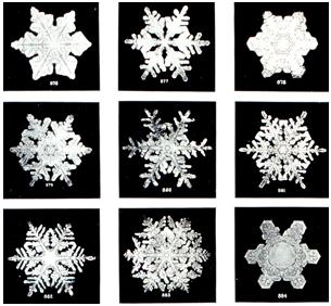
How Do Snowflakes Form? The
answer from the National Weather Service:
Q: How are snowflakes formed?
A: "
A snowflake begins to form when an extremely cold water droplet freezes onto a pollen or dust particle in the sky. This creates an ice crystal. As the ice crystal falls to the ground, water vapor freezes onto the primary crystal, building new crystals – the six arms of the snowflake. That’s the short answer. The more complex explanation is this:
These ice crystals that make up snowflakes are symmetrical (or patterned) because they reflect the internal order of the crystal’s water molecules as they arrange themselves in predetermined spaces (known as “crystallization”) to form a six-sided snowflake."
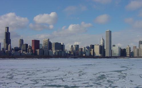
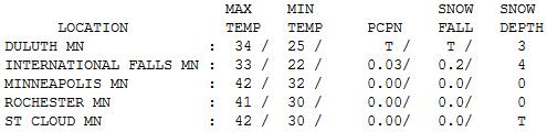
A Christmas Like No Other. I didn't run into one person yesterday who could remember a December 25 as nice (sunny and mild) as yesterday. It could have been Thanksgiving, even Halloween. Highs reached 42 at St. Cloud, the Twin Cities and Redwood Falls, 15-20 degrees warmer than average.
Paul's Conservation Minnesota Outlook for the Twin Cities and all of Minnesota:
TODAY: Sunny, windy, near-record warmth. Winds: SW 15-30. High: 47 (record is 51 F).
MONDAY NIGHT: Breezy, cooling off. Low: 28
TUESDAY: Sunny, noticeably cooler. Less wind. High: 31
WEDNESDAY: Less sun, coating of snow possible up north. Low: 18. HIgh: 33
THURSDAY: Cloudy with light snow developing Low: 25. High: 34
FRIDAY: A chance of snow, potential for a couple inches close to home. Low: 20. High: 30
NEW YEAR'S EVE: Mostly cloudy, drizzle or freezing drizzle (snowy coating up north?) Low: 26. High: 33
NEW YEAR'S DAY: More clouds than sun, few passing flurries (no major travel headaches expected). Low: 19. High: 29
Connecting The Dots
Winter and snow are synonymous. Minnesota without snow is a bit surreal, bordering on troubling. "Paul, is this climate change, drought, or just luck of the draw?" My hunch: all of the above. 2011 was the most extreme year I've ever witnessed in my 32 years as a meteorologist, second only to 2010. According to NOAA 56 percent of the USA had a "top 10 percent wettest or driest year."
Think about it: "The Mississippi and Missouri floods were higher than any other year, the Texas drought drier than any other, and the tornado season was deadlier than any other. It boggles my mind," said Weather Underground founder Jeff Masters. Climate change may be turbocharging these extremes, but some of this (brown) may be the result of a deepening drought that started in August.
All my snow-loving friends are freaked out by our neutered, Memphis-like December. Others are relieved. At some point you WILL need a heavy coat, but nothing "arctic" is brewing through January 10.
New England may see a major snowstorm in early January; maybe a couple inches of snow Thurday into Friday - with slowly improving travel over the holiday weekend.
You can sneak out the door with a jacket today: mid to upper 40s; 50 is not out of the question.
Where are we living again?
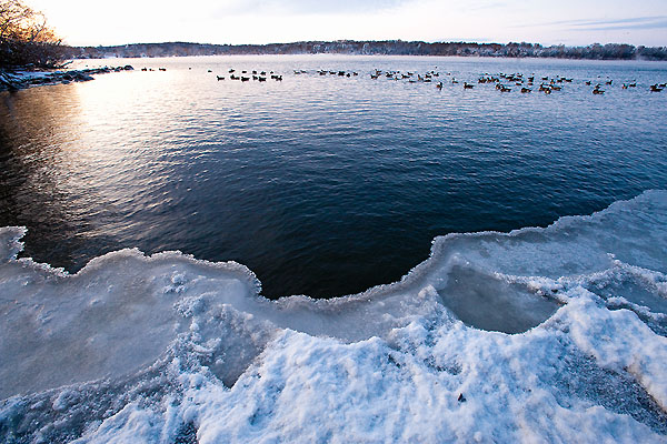
* photo above courtesy of AP.
Harsh Political Reality Slows Climate Studies Despite Extreme Year. More from
The New York Times: "
At the end of one of the most bizarre weather years in American history, climate research stands at a crossroads. Scientists say they could, in theory, do a much better job of answering the question “Did global warming have anything to do with it?” after extreme weather events like the drought in Texas and the floods in New England. But for many reasons, efforts to put out prompt reports on the causes of extreme weather are essentially languishing. Chief among the difficulties that scientists face: the political environment for new climate-science initiatives has turned hostile, and with the federal budget crisis, money is tight. And so, as the weather becomes more erratic by the year, the public is left to wonder what is going on."
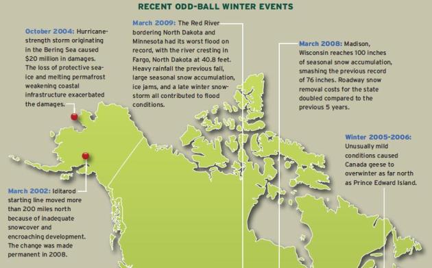
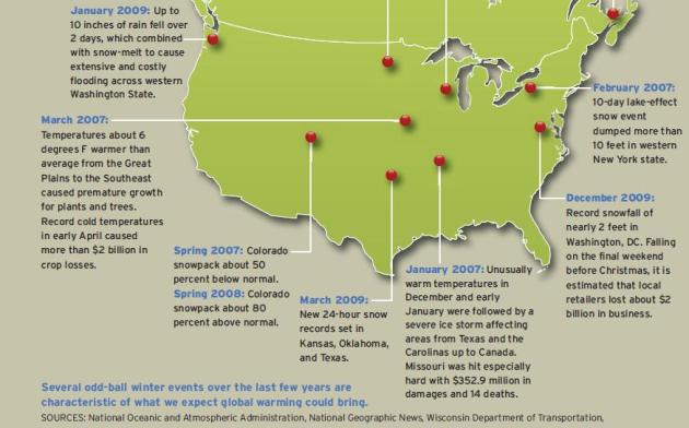
Recent Odd-Ball Winter Weather Events.
Map courtesy of the National Wildlife Fund, showing some of the more unusual weather events in recent years during the winter months.
 New Study: Warming On The Rise
. The story from
The Record Searchlight at redding.com: "
Merry Christmas climate fanatics and deniers! Here is a gift for both of you. This is a new study. New evidence that the Earth is warming. Steadily. Since 1979, the year I graduated from college. When I was 23. Next month I will be twice as old as that. Plus ten years. Thirty-three years of warming. Year after year. Kind of like Chinese water torture. Drip, drip, drip. What is most interesting about global warming is the train never ends. At any point we can look out the (metaphorical) window (from the metaphorical train) like I am right now and see the climate changing. The deniers keep the blinds pulled. Shhh, don't wake them. Look, they are smiling. Such pleasant dreams."
 Are Climate Change Reporters An Endangered Species? Huffington Post
 has the story: "
Why aren't we seeing more coverage of climate change in the media? The issue is hardly going away. And now that world governments after Durban are not planning to take action 'til 2020, we need more coverage, not less. Yet environmentalists reported a drop off in climate change reporting in 2009 and 2010, and we may well see this again when we look back at 2011. What accounts for this change? A partial answer may be the difficulties facing the market at the moment. Newspapers are not a growth industry. As media organizations downsize, an ever decreasing number of journalists are required to cover an ever increasing remit of issues. Not good for any subject."

No comments:
Post a Comment