Todd's Conservation MN Outlook for the Twin Cities and all of Minnesota:
SUNDAY NIGHT: Light snow tapering to flurries late, then decreasing clouds and still breezy. Winds: WNW 10-20mph. Low: 16
MONDAY: Calm before the NEXT storm. Another system looks to be developing and heading up from the southwest. Another chance of snow overnight. High: 27.
WEDNESDAY: Windy, with snow. Heaviest snow once again setting up across the northern half of Minnesota. Low: 20. High: 32.
THURSDAY: Not as windy. Partly sunny with a light snow chance late, mainly north. Low: 13. High: 32.
FRIDAY: Mix of clouds and sun. A few afternoon snoww showers. Low: 18. High: 30.
SATURDAY: Lingering flurries early, clearing through the afternoon. Low: 14. High: 25.
Sunny Saturday
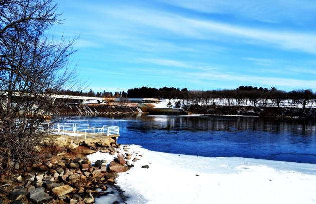
My wife, two young boys and I made a trip up to St. Cloud yesterday to see my old stomping grounds and alma mater, SCSU (St. Cloud State University). Not sure I really miss the college life (living off of Ramen Noodles and Spaghetti O's), but I sure do miss the scenery. It looked especially nice yesterday under a mostly sunny sky.

Note the open water, it's actually downstream from the Hydroelectric Plant
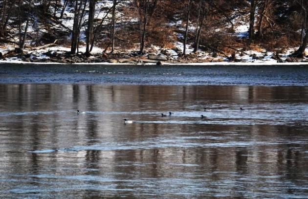
I also saw several birds that resembled the Common Loon (Is this possible?)
Let me know at my email: TNelson@WeatherNation.net
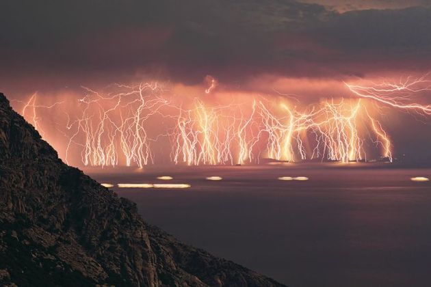
Lightning From Greece
This is a neat picture from Earth Science Picture of the Day
"This 70-shot photo sequence shows a lightning display that occurred during a severe thunderstorm last summer on the island of Ikaria, Greece, near the southwestern coast of Turkey. The stormy weather actually developed during my photo session of the total lunar eclipse on June 15, 2011 (see related link below). To make this shot, I set my camera on a tripod taking 20-second exposures continuously. More than 100 lightning bolts were captured in this sequence, the majority of which were potent cloud-to-ground strikes."
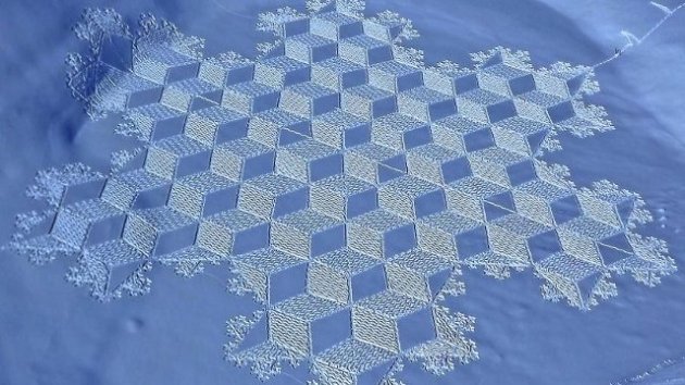
Crazy Snow Art
I guess the Aliens are giving up corn fields to make crop circles... LOL
"Are aliens giving up cornfields for cold, mountain air? Nope. Turns out these incredibly awesome snow designs are the work of decidedly human artist Simon Beck, who takes the concept of a crop circle to new heights by strapping on a pair snowshoes and getting to work."
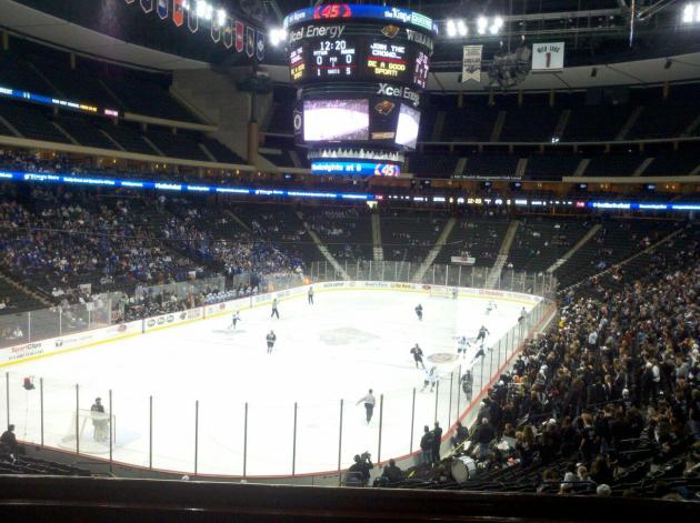
MN High School Girls Hockey State Tournament
I love tourney time, especially the hockey tournaments. My sister Michelle, a senior in high school and commited to play college hockey next year in Wisconsin, was at the game AA championship game yesterday and sent me this picture. I bet I can speak for most MN high school hockey players (or any MN high school sport), making it to state is a dream growing up. I played for the Osseo Orioles in the year 2000 and lost in the section final (1 game before the state tournament). Good luck to all the teams in the state tournaments this upcoming March!
I Always Remember a March Madness Snow Storm
It never failed, growing up in Minnesota, there seemed to always be a March snow storm around tourney time. I guess it fits with tourney time now just starting that we'd have a threat for heavy snow (not just once). Not only do we have a chance for some snow on Sunday, but the next storm (Tuesday/Wednesday) storm looks even bigger. Here are the current winter weather headlines for the Sunday system:
Winter Storm Warning
Timing: Thru 6AM Monday
Snowfall: 6" to 10"
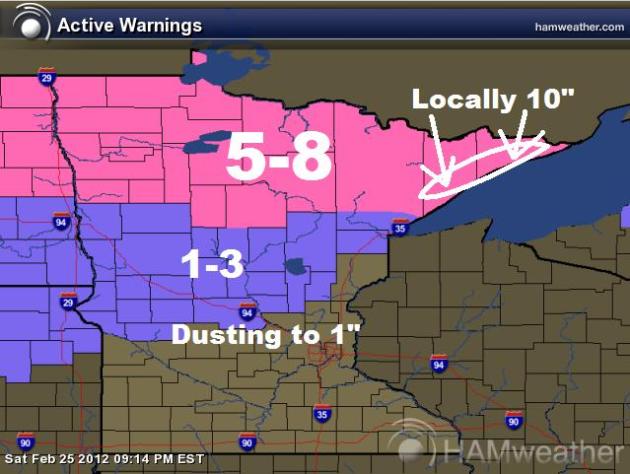
Snowfall Forecast
This is a glance at the snowfall forecast for Sunday. I still think heaviest is going to be along the northern third of the state, especially the North Shore, but light accumulations will still be found in central Minnesota.
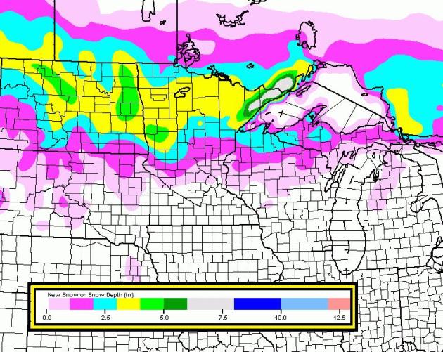
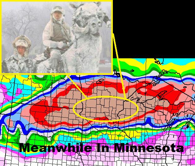
How About That Tuesday/Wednesday Storm Potential
OK, I couldn't help myself when I saw yesterday's extended GFS model run for the Tuesday/Wednesday storm system, I drew up a little Star Wars (Tauntaun) humor (for anyone who has watched Star Wars, you'll get it). I almost fell out of my chair when I was this GFS solution (Way too early to take it literally), but if it verifies, this will be the biggest storm of the winter season!
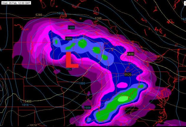
Tuesday/Wednesday Storm
This storm really does look like a doosey. Keep in mind that this forecast storm isn't even on land yet, so the forecast is likely to change, but take a look at the image below. The #2 storm is the Tues/Wed storm, which at this point, looks like the biggest storm of the winter season by far. Keep in mind that this storm forecast is likely to change as it moves inland, stay tuned!
I'll have more on the storm this later, thanks for checking in and have a great rest of your weekend!
Don't forget to follow me on Twitter @TNelsonWNTV
-Meteorlogist Todd Nelson-
No comments:
Post a Comment