By Paul Douglas
"Choose a job you love, and you will never have to work a day in your life" said Confucius.
4 years ago I thought my TV career was
over. If you had told me I'd be launching a national weather channel
from Minnesota I'd have laughed and asked you to back away from the
crazy-sauce. I can predict the weather (on a good day) but business?
Good luck forecasting the next opportunity...or threat.
No business has ever turned out like I thought it would. I'm always humbled.
The happiest people are often those who
don't distinguish between work & play. Keep your personal radar up
for unusual opportunities. Hedge your bets, and embrace failure. If you
don't fail it means you're not really trying. Speaking of failure a
holiday is coming. What can go wrong?
A storm ripping north along a stalled front
squeezes out 2-4" rain today. A Flood Watch is posted; watch for wet
basements, street flooding and painful commutes. Saturday looks like the
coolest, wettest day of the weekend. But, sunscreen stages a comeback
on Sunday; I'm still going out on a limb predicting 90 F. Storms Sunday
night and early Monday give way to some sun for Memorial Day. We've seen
worse. Updates on the blog.
____________________________________________________________________________________________
Thanks
to Timmoth Burr out of Duluth for this picture. Heavy rain on Wednesday
allowed the creek behind his out to swell up. Timmothy said he's never
seen that creek this swollen!

Todd's Conservation MN Outlook for the Twin Cities and all of Minnesota:
THURSDAY: Showers and T-storms linger, 1-2" rain? Showers taper PM hours. High: 72
THURSDAY NIGHT: Lingering showers, tapering overnight. Low: 52
FRIDAY: Drier day with some sun. Winds: NW 10. High: 73
SATURDAY: Showers, T-storms likely. Probably the wettest day of the holiday weekend. Winds: E 10-15. Low: 56. High: 72
SUNDAY: Best lake day? Hot sticky sun, cooler north. Winds: S 20+ Low: 60. High: nearing 90
MEMORIAL DAY: Cooler, few T-storms likely. Winds: SW 15. Low: 63. High: 78
TUESDAY: Intervals of sun, drying out. Low: 54. High: 71
WEDNESDAY: More sun, refreshing. Low: 52. High: 73
Blog for Thursday, May 24th, 2012
Thanks
to @nikmartinezzz for this picture out of Miami, FL. An incredible
9.7" of rain fell Tuesday, which shattered the old record of 3.44" set
in 1901.

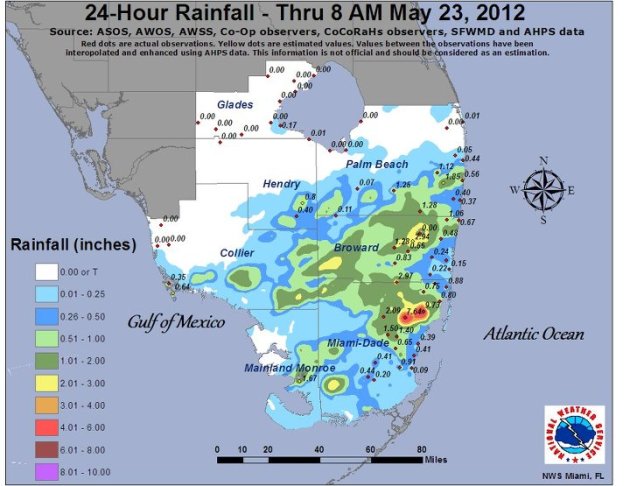
Miami Rain
Stationary storms kept rain heavy in pockets. Look at the image below from the National Weather Service out of Miami, FL
Heavy Rain Potential Continues
Unfortunately
for folks in southern Florida, the heavy rain potential continues
across south Florida through the next couple of days.
This is the rainfall forecast over the next 3 days. It suggests an additional 1" to 3" or more.

Heavy Rainfall Forecast in the Upper Mississippi Valley
A
slow moving front across the Upper Mississippi Valley will focus heavy
rain and isolated severe thunderstorms across the region. The 3 day
rainfall (Wednesday-Saturday) forecast shows over 3" or rain with the
potential of flash flooding.

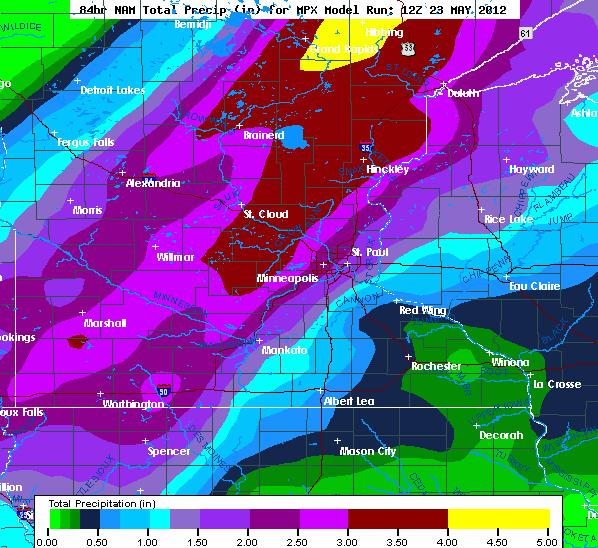
NAM Forecast
This
is a look at the NAM, one of the various models out there. This one is
suggesting a 2" to 4"+ swath of rain through parts of Minnesota! It is
going to be a soggy one!
Flash Flood Watch
The
National Weather Service has issued a Flash Flood Watch through PM
Thursday for rainfall amounts that could be in excess of 3"

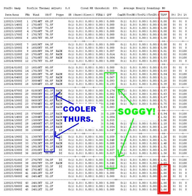
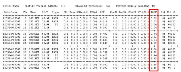
COBB Output
This
is a look at the text data from the NAM forecast from AM Wednesday,
which showed the potential of over 1" or rain falling through Friday.
Some the of the heaviest rain expected PM Wednesday through Thursday.
Temps staying in the 'cool' category as we're locked under clouds and
soggy weather.
GFS Suggests More Rain
The GFS model suggests that we'll get over 2" of rain in the Twin Cities!
Thunder Thursday Risk
The same, slow moving front, will kick out another chance of severe
weather across parts of Wisconsin Thursday. Hail and high winds will
likely be the primary threats with any of the strong storms that
develop, but heavy rain is looking more significant.
Wedding Tornado
There's an old saying about rain on your wedding day means good luck, but what about tornadoes? This video is CRAZY!
"This
is my nephew and his beautiful brides wedding ceremony. A perfect
country wedding complete with wheat, cowboy hats, boots,and tornados.
The tornadoes were about 4 miles away and were not moving"

What's Up Bud?
The National Hurricane Center continues there advisories on Tropical Storm BUD in the Eastern Pacific.

BUD Forecast

Memorial Day Outlook
I
know a lot of folks probably have plans to fire up the BBQ. This is an
early look at weather conditions for Monday, May 28th... Memorial Day!

Memorial Day High Temps

____________________________________________________________________________________
Question:
"Paul,
At least 4 times since mid april rain is showing up on my smartphone
radar. It is heading for Crookston . However just before it get here it
breaks up and goes around us on both sides. Sometimes it even gets back
together after Crookston , heading for Thief River Falls. How come this
happens so often? We are very dry here. "
Thanks. Jim Borkowski
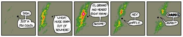
Does it look something like this?
Thanks to http://xkcd.com/831/ for this!
I don't know of anything (topographical) that would divert storms away from Crookston, though, I remember when storms seemed to always divert around us when I was in college... I called
it the St. Cloud force field. Maybe it was because I just wanted it to
storm so badly, I dunno. Sometimes weather patterns can persist;
droughts, severe storms, floods, etc. This is such a localized event,
though, that it's hard to tell. Maybe just bad luck that the heavier
rain is missing you altogether. It appears that you'll be missing out on
this heavier stuff through Thursday as well, most of it will stay to
your east. I'll put in a good word... hopefully a decent rain event
heads your way in the near future.
Thanks for checking in and have a great rest of your week!
Don't forget to check me out on Twitter @TNelsonWNTV

No comments:
Post a Comment