76 F. average high for June 6.
97 F. high temperature a year ago, June 6, 2011.
5:27 am sunrise today.
8:57 pm sunset this evening.
Mid-90s expected Saturday and Sunday, winds from the south at 15-30 mph.
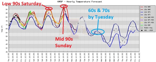
Heat Spike. I'm feeling better about going out on a limb 3 days ago and predicting 90s for the weekend, basically hanging my hat on the ECMWF (European) model. The atmosphere will probably be "capped" Friday (too hot, dry and stable aloft for any strong storms nearby) - meaning highs near 90. Mid-90s are likely on Saturday, but I suspect the models above don't have a good handle on Sunday, when high temperatures may be just as hot.
Hot Enough. The ECMWF solution (above) has been remarkably consistent for the past 3-4 days - still hinting at mid 90s both Saturday and Sunday, with no rain either day. A few showers/T-storms may arrive late Sunday night into Monday morning, marking the return to a more comfortable airmass next week. It's early, but the same model is predicting near 2" of rain next Friday. We'll see, but the more I look at the maps the more convinced I am that this weekend may be the best cabin/pool/lake weekend for some time to come.

Weather Nugget: "The last drop of rain in Flagstaff was on April 26th, a dry spell of 40 days so far. With the driest time of year upon us, this could go on for quite a while!"

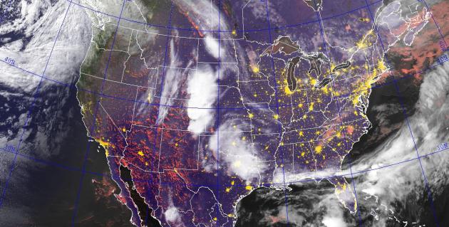
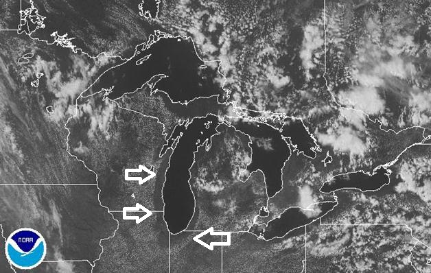
NexSat. I'm a fan of the Naval Research Lab site, which has created some new and novel ways to display visible and infrared (temperature derived) satellite imagery from NOAA. The image above was taken at 9:30 pm yesterday, showing strong/severe (tornado-producing) storms from the Denver area into the central Plains.
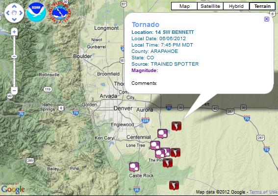
Close Call. Late Wednesday came reports of a weak tornado near DIA, Denver International Airport. As many as 4-5 separate tornadoes were spotted over the far southeastern suburbs of Denver Wednesday evening, in Arapahoe County. Click here to see the latest list of NOAA storm reports.
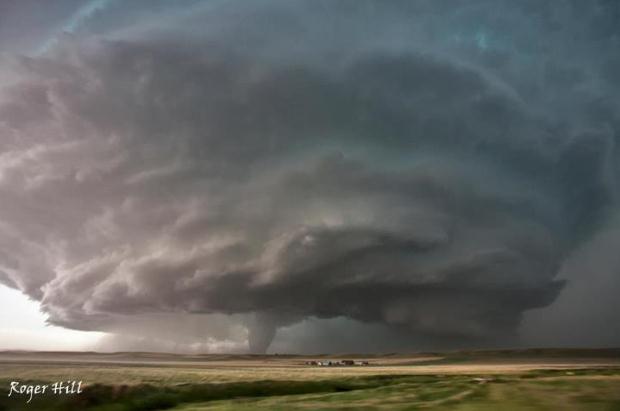
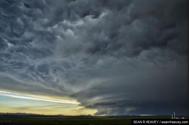
An Awesome Sight. Professional photographer Sean R. Heavey captured this awe-inspiring shot near Big Sandy, Montana Tuesday, complete with wall cloud below and lumpy, cumulonimbus mammatus clouds dangling from the thunderhead anvil above. Check out his photos here.
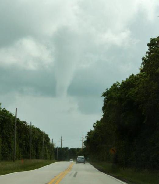
"Waterspout!" The Key West, Florida office of The National Weather Service has the details, via Facebook: "Here is the first of two waterspout photos taken by official storm spotter Joe Sheriff. This waterspout developed at around 935 am this morning about 1 mile east-southeast of Ocean Reef. Waterspout duration was approximately 7 minutes."
May Weather Recap. Greg Spoden has an update on the second wettest May in recorded history for Minnesota, and a few other weather nuggets of interest; courtesy of the Minnesota Climatology Working Group:
- May 2012 precipitation totals were
extraordinarily high along a broad arc that extended from southwest
Minnesota into Minnesota's Arrowhead region. Along this swath, monthly
precipitation totals in excess of eight inches were common.
- While much of the southeastern two-thirds
of Minnesota received abundant rainfall, the northwest corner of the
state was missed by most of May's heavy rainfall events. The U. S.
Drought Monitor places some northwest Minnesota counties in the
"Moderate" drought category.
- Overall, Minnesota's drought situation has
improved significantly when compared with early May when 60 percent of
the state was said to be in "Moderate" or "Severe" drought.
- Stream flows are very high in southwest,
central, east central, and northeast Minnesota. Stream discharge values
in these watersheds rank above the 90th percentile when compared with
historical data for the season.
"Ask Paul". Weather-related Q&A.
"We have this ongoing discussion at our house regarding whether it's too humid to open up the windows at night - any asuggested parameters? We have a weather station that gives us both inside and outside temperature and humidity."
Thanks,
Kim Kvam, Granite Falls, MN
Kim - I would suggest looking at dew point, instead of relative humidity (you can see the latest Twin Cities dew point here, courtesy of NOAA). Relative humidity fluctuates, sometimes wildly during the day, based on the temperature, whereas dew point is more constant, an (absolute) measure of how much water is in the air. As a rough rule of thumb when dew points are in the 50s - most people would find that comfortable. When the dew point rises above 65 I might consider shutting the windows. A dew point over 70? Tropical air - even air conditioning may not be able to keep up.
________________________________________________________________________________
Hello - what is called when the clouds move away from the lake? And why does in happen?
I was watching the Midwest (Great Lakes) satellite for the Minnesota weather (thunderstorm), yet I noticed the cloud cover pulling back from Lake Michigan. Is that due to winds coming from the north/northeast, and/or also the water on Lake Michigan is cooler (and drier) than the air on land?
Thank you,
(Another) Paul in Minneapolis
Paul (may I call you Paul?) - you sent along a great example of lake effect clouds, a sort of "reverse-lake-effect" during the summer months. You have the right idea: water takes much longer to heat up than land. Great Lakes water temperatures are routinely 20 degrees cooler than surrounding land temperatures, which heat up rapidly with the sun so high in the sky in June. As air heats up it rises, allowing stable, lake-cooled air to push 5-50 miles inland. These miniature cool fronts pushing away from cooler lakes can set up boundaries capable of firing off showers and T-showers. This "sea-breeze" effect triggers late-day T-showers like clockwork many summer days across Florida. It all ties back to differential heating of land and water. In November the process reverses - lake water is warmer than chilly Canadian, heating the air from below, sparking lake-effect clouds and (snow) showers downwind of the Great Lakes. Great question!
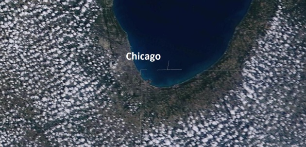
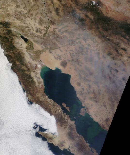
Time For Your Close-Up. Here is Wednesday's NASA MODIS 250 meter close-up of the southern tip of Lake Michigan. Air temperatures shot up into the low to mid 70s, heating the air above the land, causing fair weather cumulus to sprout 20 miles inland. But lake water temperatures off Navy Pier are still in the mid to upper 50s, and by mid afternoon that lake-cooled air had been pulled inland - resulting in a cloud-free zone near the lake.

1) Totally eliminate your industry’s persistent customer pain points.
Each industry has practices that drive customers crazy.
Technology providers drive customers crazy with technical support that often requires long waits on hold and hopelessly complex interactions (“Just find the serial number on the back of your device and type that into the space provided along with your IP address and the exact wording of the error message you encountered”)."

"Orsos Island" - The Smallest Floating Island Yet In A Fast Growing Market. Who are these people, and why can't I be related to one of them? Good grief. For a new level of wretched excess, check out this story from gizmag.com: "The Wally Island was a 99 meter (325 feet) "gigayacht" design that dwarfed the vast majority of luxury megayachts and reconceived the yacht as a floating personal island, a mobile address that can be used as a home, an entertaining space or even a moving exhibition or show space. At an estimated US$200 million, the Wally Island was not for the common man, but the concept appears to have ignited a flurry of activity in the marine industry, with these new designs all more focused on a comfortable movable living space framed as a floating island more than a boat."
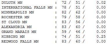
Another (Mostly) Fine June Day. The sun was out most of the day Wednesday, a few late-day instability showers drifted down I-35 into the northern suburbs of St. Paul by evening, but there were few complaints - dew points still reasonable, in the 50s. Highs ranged from 59 at Grand Marais (where spring comes only reluctantly) to 82 Twin Cities, 83 at St. Cloud, Alexandria and Redwood Falls.
“ In every triumph there's a lot of try. ” - Frank Tyger
Paul's Conservation Minnesota Outlook for the Twin Cities and all of Minnesota:
TODAY: Some sun, stray T-shower. Winds: S 10-15. High: 84
THURSDAY NIGHT: More humid with another shower or T-shower possible. Low: 67
FRIDAY: Hot sun, storms up north. Winds: SW 15-20. High: 90
FRIDAY NIGHT: Storms over northern MN. Warm and muggy central and southern MN. Low: 68
SATURDAY: Stinking hot. Dew point: 69. Feels like 97-98. High: 94
SUNDAY: Sizzling sunshine. Dew point: 72. Feels like 100. Winds: S/SW 10-20+. Low: 71. High: 96
MONDAY: Early showers, slow PM clearing - cooling off. Low: 66. High: 79
TUESDAY: Comfortable sun, less humid. Low: 59. High: 75
WEDNESDAY: Clouds increase, PM shower. Low: 56. High: 74

What is Heat Index?
"If you saw a heat wave, would you wave
back?" asked humorist Steven Wright.
Let me ponder that one.
Leave
it to a meteorologist to leave you feeling worse than you thought possible. In
winter it's a steady drumbeat of windchill-babble. Summer brings
the ubiquitous "heat index", which is a measure of heat and humidity.
Bottom line: when there's a lot of water in the air, as there will be this weekend, your body can't cool itself effectively via
evaporation. Sweat evaporating off your skin has a cooling effect. That's why
you feel chilled stepping out of the shower. But when dew points surge above 70 you can easily overheat; the risk of heat
exhaustion (clammy skin) and heat stroke (dry skin, heart palpitations)
increases exponentially.
Mid-90s are possible over the weekend; a few thermometers may brush 100. The heat index may top 100
under a blazing sun. I suspect this will be the hottest temperature spike of
2012 so far. Evacuate to the lake.
A stray T-shower may chase you you indoors today; most storms push across far northern
Minnesota.
After a dry, sauna-like weekend, Sunday night storms herald
the arrival of cooler, Canadian air - a comfortable front next week.
* Heat Index Calculator courtesy of the Green Bay office of The National Weather Service.
Climate Stories....

U.N. Report Warns Environment Is At Tipping Point. Here's an excerpt from a story from seattlepi.com: "RIO DE JANEIRO (AP) — The earth's environmental systems "are being pushed towards their biophysical limits," beyond which loom sudden, irreversible and potentially catastrophic changes, the United Nations Environment Program warned Wednesday. In a 525-page report on the health of the planet, the agency paints a grim picture: The melting of the polar ice caps, desertification in Africa, deforestation of tropical jungles, spiraling use of chemicals and the emptying out of the world's seas are just some of myriad environmental catastrophes posing a threat to life as we know it."
Photo credit above: "Brazil's Secretary for Climate Change in the Ministry of the Environment Carlos Klink holds up a copy of UNEP's Global Environment Outlook 5 (GEO-5), in Rio de Janeiro, Brazil, Wednesday, June 6, 2012." Photo: Felipe Dana / AP
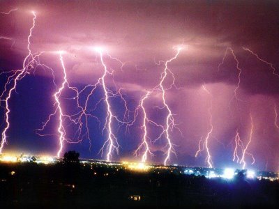

Image credit above: 'Ghost trees' are victims of rising sea levels.

AGPIC
ReplyDeleteThank you for the great blog post! This blog is truly interactive. I appreciate all the work you’ve been doing. Good stuff. This can be exactly what i was looking for. Continue the good work.