78 F. average high for August 29.
81 F. high on August 29, 2011.
Mid-90s likely today; 100 F. not out of the question over far southern Minnesota.
Red Flag Warning. The combination of intense heat, bright sun and gusty winds will breed ripe conditions for brushfires today, the warmest day in sight. Details from the local NWS office:
DANGEROUS WILDFIRE CONDITIONS ARE EXPECTED THURSDAY
AFTERNOON IN SOUTH CENTRAL AND SOUTHEAST MINNESOTA...

.A RED FLAG WARNING IS IN EFFECT FOR LOCATIONS NEAR AND SOUTH OF
A LINE FROM ROUGHLY NEW ULM...TO NORTHFIELD...TO RED WING IN
MINNESOTA THURSDAY AFTERNOON. HOT TEMPERATURES ON THURSDAY
COMBINED WITH BREEZY SOUTHWEST WINDS OF 15 TO 20 MPH...WITH GUSTS
TO 25 OR 30 MPH...ALONG WITH MINIMUM RELATIVE HUMIDITY BETWEEN 20
AND 25 PERCENT SHOULD LEAD TO DANGEROUS WILDFIRE CONDITIONS
ACROSS THE WARNING AREA.
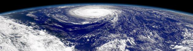
"But storms of Category 3 and above are likely to become more common. In fact, scientists have already observed an uptick in intense hurricanes since 1970, according to an upcoming report from the Intergovernmental Panel on Climate Change, which Abraham has reviewed. And a rating of Category 3 is enough to destroy lives." - excerpt from a story about a hypothetical "Category 6" hurricane from Discovery News below.

Storm Surge. This is what hurricanes do; the combination of low pressure and sustained (extreme) winds carving out a dome of water that is pushed ashore out ahead of the eye. Tides can rise 5-10-15 feet in a matter of minutes, cutting off escape routes, increasing the risk of drowning in the storm. Reed Timmer took this remarkable photo as Isaac's storm surge overran Lakeshore, Mississippi. Thanks to Reed and Kory Hartman at Severe Studios for passing this along.
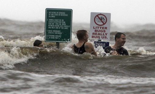
Bad Idea. Here's what NOT to do when a hurricane approaches: "Against the advice of authorities, young people frolic in the high surf on the Lake Pontchartrain lakefront in Mandeville, La. as Isaac batters the north shore with high winds and high tides, Wednesday Aug. 29, 2012." (AP Photo/The Times-Picayune, Ted Jackson)
Isaac Headlines:
* Arrival falls on the seventh anniversary of Hurricane Katrina
* New Orleans levee systems holding up well.
* Water has toppled over at least one rural levee. Possibly two.
* At least two dozen people were stuck and in need of a rescue on the east bank of Plaquemines Parish.
* Authorities issued a new mandatory evacuation order in the parish for a portion of the west bank of the Mississippi River out of concern that more storm surge would be pushed into the area.
* Mandatory evacuations on the east bank and other portions of the west bank had been issued earlier.
* Water driven by the large and powerful storm pushed over the top of an 18-mile stretch of one levee in Plaquemines Parish south of New Orleans, flooding some homes in a thinly populated area. The levee is one of many across the low-lying coastal zone and not part of New Orleans’ defenses.
* More than a half million Entergy Customers without power.
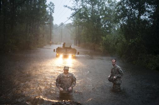
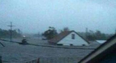
Searching For Survivors. Details: "National Guard soldiers look for troubled residents during Tropical Storm Isaac in Pearlington, Miss., Aug. 29, 2012. Tropical Storm Isaac hovered over the Gulf Coast on Wednesday morning, punishing southeast Louisiana and parts of Mississippi with wind gusts of 75 mph, horizontal rain and the threat of calamitous flooding." (Brendan Hoffman/The New York Times)
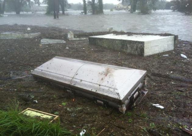
A Ghoulish Sight. The storm surge (8-12 feet above normal high tide) was so powerful it unearthed coffins, as reported by Jason Whitely via Facebook: "Tombs and caskets are floating in flood water from an above ground cemetery near Braithwaite, LA where Hurricane Isaac's storm surge topped a local levee."
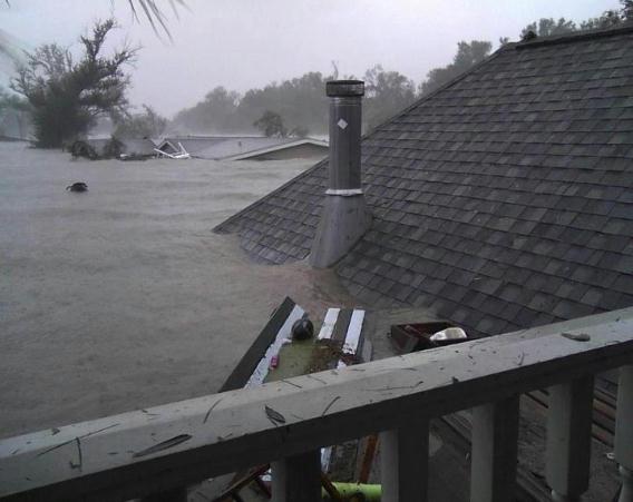
Staggering Flooding. The parishes just south and east of downtown New Orleans (not protected by the new $14 billion levee) were hardest hit, as reported by Jeff Leblanc via Twitter: "this was taken in Braithewaite"pic.twitter.com/AundRtPu
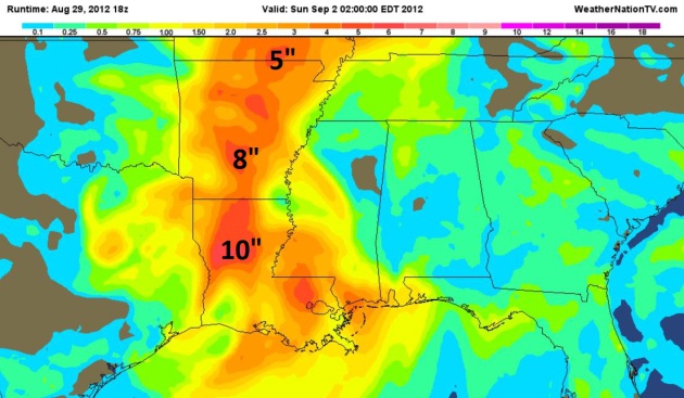
Additional Rainfall Thru Sunday. Another 10" of rain from the soggy dregs of Isaac may soak Shreveport, Louisiana, with some 8" amounts predicted near Little Rock, 5" amounts for St. Louis. Although it's coming too late for most farmers this summer, water from Isaac will help to recharge soil moisture and underground aquifers, helping in 2013.
Real-Time Winds. This is one of my favorite sites - it did a very good job of picking up Hurricane Isaac over Louisiana yesterday. It combines current conditions with a high-resolution NOAA NDFD wind forecast (more like a "nowcast") looking out 6 hours or so. Very cool.
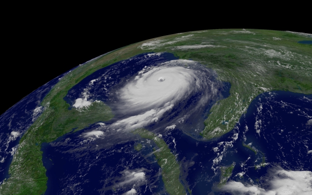
Could Isaac Join List Of Billion Dollar Storms? We won't know for a couple of days or weeks, but flood and surge damage from Category 1 Isaac is going to run into the hundreds of millions of dollars. WWL-TV has more details: "Here is a complete list of tropical storms and hurricanes causing at least $1 billion in damage to the U.S. since 2000. (Listed chronologically.)
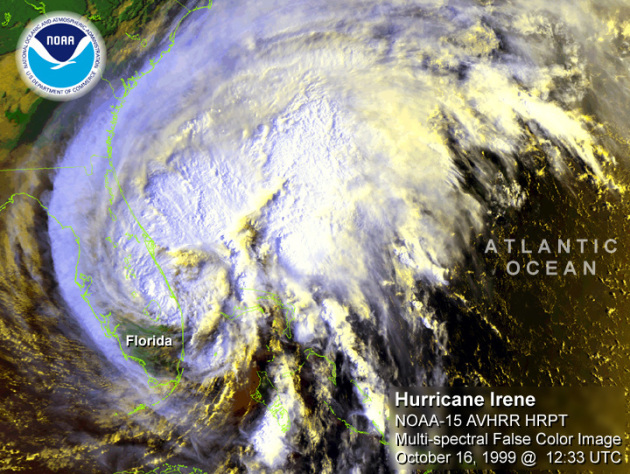
Hurricane Irene, August 2011. Category 1 hurricane made landfall over coastal NC and moved northward along the mid-Atlantic Coast (NC, VA, MD, NJ, NY, CT, RI, MA, VT) causing torrential rainfall and flooding across the Northeast. Over seven million homes and business lost power during the storm. Damage estimated to be $9.8 billion.
Tropical Storm Lee, September 2011. Wind and flood damage across the Southeast (LA, MS, AL, GA, TN), followed by considerably more damage from record flooding across the Northeast (PA, NY, NJ, CT, VA, MD). Pennsylvania and New York were most affected. Property damage estimated at $1.3 billion."
Hurricane Safety: When The Lights Go Out. CNN.com has some very good advice; here's an excerpt: "Hurricane shutters, water jugs and batteries are not the only things to consider when extreme weather threatens the coast. Officials said Wednesday morning that more than half a million customers were without power in Arkansas, Louisiana, Mississippi, Texas and Alabama as Hurricane Isaac bore down on the Gulf Coast -- and in several regions, experts said the worst is yet to come. At least 5,200 people spent Tuesday night in Red Cross shelters, according to Red Cross spokesman Jonathan Aiken. The agency opened 80 shelters in six states. Power outages and evacuations can pose safety issues, especially for those managing chronic illnesses."
Isaac Brings Back Painfull Katrina Memories. What are the odds? 7 years after Katrina, to the day...Isaac arrives. But the storm proved that a "mere Category 1" can still produce widespread and severe flood-related damage. Sometimes the weakest tropical storms and hurricanes (moving the slowest) squeeze out the most extreme rainfall amounts. Here's an excerpt of a story at Bloomberg Businessweek: "NEW ORLEANS (AP) — As she loaded supplies into her car to prepare for Isaac, Linda Grandison's mind rewound to the nightmare of Katrina: Back in 2005, she had to flee her family's flooded home and waited on a bridge for more than three days before being rescued by helicopter. Though Isaac is far less powerful than the historic hurricane that crippled New Orleans, the system was on an eerily similar path and forecast to make landfall on the seventh anniversary of Katrina, raising familiar fears and old anxieties in a city still recovering from a near-mortal blow seven years ago."
Hurricane Irene: Vermont Remembers The Storm One Year Later. Nobody predicted that the worst impacts of Irene would come hundreds of miles inland, days after landfall, in Vermont? Historic flooding resulted, as recounted in this Huffington Post story; here's an excerpt: "WAITSFIELD, Vt. (AP) — For some, there will be block parties and parades. For others, a moment of silence. Or it might be just another day of cleaning up the mess. But if there's one unifying event, it'll probably be the sound of all Vermont's church and town hall bells reverberating simultaneously through the same mountain valleys that Hurricane Irene's floodwaters shredded exactly a year ago. Gov. Peter Shumlin has called for the bell-ringing commemoration as Vermonters make plans to pause on Tuesday or the days around it to reflect on how far the state has come since the remnants of Irene unleashed the worst flooding in recent memory, killing six people, wiping out hundreds of homes and businesses, and cutting off whole towns with miles of wiped-out roads and dozens of destroyed bridges."

NASA To Field UAV's To Monitor Hurricanes. Drones providing data to make hurricane forecasts more accurate? Government Security News has the story; here's an excerpt: "The National Aeronautics and Space Administration (NASA) will field two unmanned aircraft capable of high altitude, long duration observation, to fly over hurricanes during the peak of hurricane season in September. The two surplus Northrop Grumman Global Hawks, said NASA on Aug. 15 in a post on its Web site, are part of the agency’s Hurricane Severe Storm Sentinel Mission, or HS3. Both Global Hawks will be flying out of NASA Wallops Flight Facility in Virginia in September, too late for Hurricane Isaac currently lashing the Gulf Coast, but in time to monitor the peak of the hurricane season in the Atlantic Ocean. The hurricane season lasts from June 1st to November 30th, with the most active period usually falling in September, when wind shear that can tear storms apart is low and ocean temperatures are at their warmest."
Will Hurricanes Ever Reach Category 6? I hope I'm not around if and when we achieve this dubious meteorological milestone. The answer: probably not, but just the fact that some are asking the question is troubling enough. Here's an excerpt from a story at Discovery News: "As it moved toward to coast of Louisiana today, Hurricane Isaac was upgraded to a Category 1 on a scale that tops out at 5. With wind speeds of about 75 miles per hour, Hurricane Isaac just barely earned the designation. Only at minimum speeds of 74 mph do winds become strong enough to cause significant damage, according to the National Hurricane Center. Even though Category 5 storms, which sustain catastrophic gusts that blow at 157 mph or higher, are extremely rare, scientists predict an increase in strong hurricanes with global warming. That raises the question: Will we ever need to push the hurricane scale up to a 6? Probably not, experts say. Even as warmer ocean temperatures provide more fuel for hurricanes, there are several factors that limit how powerful the storms can become."
"Ask Paul". Weather-related Q&A:
Dear Mr. Douglas,
As we all suffer through this overheated summer, following on an unprecedented run of months well above normal temperatures, it is certainly understandable to wonder about what connections North American temperatures rises may have with global trends.
It is interesting to me that on those occasions when you have chosen to write in your column on the subject, I can recall no mention of what's going on in the rest of the world. Especially do I have in mind the cool and rainy spring in Northern Europe, which weather has persisted into the summer.
Perhaps you'd like to comment on this phenomenon in your column.
Yours very truly,
James Howard
Wayzata
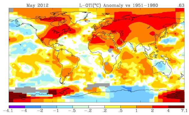
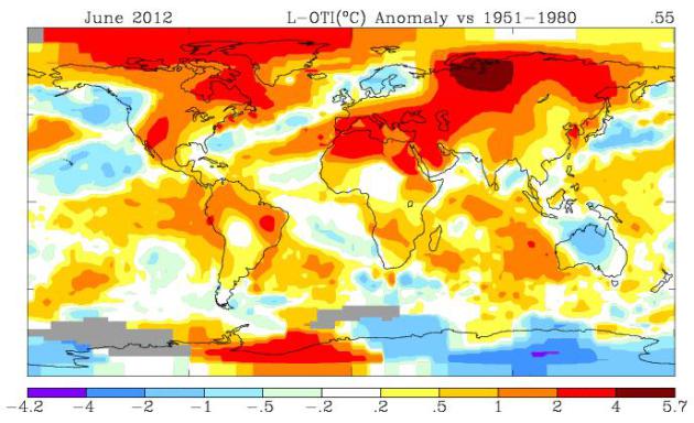
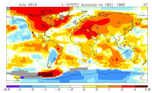
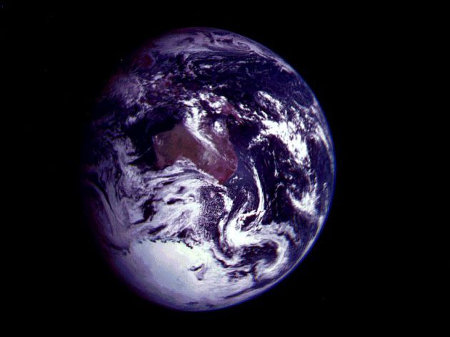
James - your question is a good one. Anyone can cherry-pick data to make a point. If the USA is breaking heat records while the rest of North America experiences unusually cool weather, it would be much harder to make a case that larger trends are at work. Keeping a global perspective is tricky, even for meteorologists, who usually have a local bias, at best watching weather patterns for the USA. It is true that the UK and much of northern Europe did experience a cool spell during the spring and part of the summer. I checked one of NASA's databases to find monthly temperature anomalies for the entire planet, the actual departure from normal, averaging highs and lows for every day, over all continents. The result is above. The bright-red shaded areas show an average temperature anomaly of +2 C, or nearly 4 F. Even the southern hemisphere (where it's winter, I'm told) showed a slightly warmer bias. It's true that one year doesn't "prove" anything. But we've seen these trends year after year, for several decades now. No, you can't look out your window and make grand pronouncements about global warming. But the trends are fairly significant. All I'm trying to do is share the trends - not make policy suggestions. I'm a small businessman; I think the market will ultimately drive innovation and help us mitigate some of the warming we're seeing. What I can't predict is when our political leaders in Washington D.C. will start to take this seriously. On that your guess is as good as mine.
Maps above created by NASA's Goddard Institute for Space Studies. You can call up any month, and get a global plot.

One Step Closer To Cyborgs: Scientists Create Biological Tissue With Embedded Wiring. Cue The Terminator. Here's an excerpt from gizmag.com: "Under its human skin, James Cameron’s Terminator was a fully-armored cyborg built out of a strong, easy-to-spot hyperalloy combat chassis – but judging from recent developments, it looks like Philip K. Dick and his hard-to-recognize replicants actually got it right. In a collaboration between Harvard, MIT and Boston Children's Hospital, researchers have figured out how to grow three-dimensional samples of artificial tissue that are very intimately embedded within nanometer-scale electronics, to such an extent that it is hard to tell where one ends and the other begins. It could lead to a breakthrough approach to studying biological tissues on the nanoscale, and may one day be used as an efficient, real-time drug delivery system – and perhaps, why not, even to build next-generation androids."

12 Brunch Orders Worse Than A Steak Dinner. I want to thank my dear sister for passing this one along; thanks for ruining Eggs Benedict (forever). Back to my broccoli. Here's an excerpt from shape.com: "...The one redeeming quality about this brunch staple: It contains protein-rich eggs, which are a great source of selenium and vitamin D, says Margaux J. Rathbun, certified nutritional therapy practitioner and creator of nutrition website Authentic Self Wellness. But the benefits of this calorie bomb end there, thanks to toppings like ham and and high-fat Hollandaise sauce—all served on an English muffin....Exactly how bad are they? Eggs Benedict from one popular breakfast chain come in at a whopping 1,050 calories and 57 grams of fat."
Heating Up. At least the dew point isn't in the 70s, like it was much of July. Under a hazy-blue sky highs ranged from 73 at Grand Marais to 91 St. Cloud, 93 in the Twin Cities.

Paul's Conservation Minnesota Outlook for the Twin Cities and all of Minnesota:
TODAY: Hot sun. Fire Weather Watch. Dew point: 55. Winds: SW 15. High: 94
THURSDAY NIGHT: Warm and sultry. Low: 69
FRIDAY: Not as hot with a dip in humidity. Sun lingers. Dew point: 49. High: 86
SATURDAY: Lake-worthy with warm sunshine much of the day. Dew point: 60. Winds: SE 10. Low: 67. High: 85
SUNDAY: Sticky again, stray PM T-storm up north? Dew point: 64. Low: 72. High: 87
LABOR DAY: Some sun, slightly cooler. Low: 69. High: 87
TUESDAY: Partly sunny, less humid. Dew point: 54. Low: 66. High: 84
WEDNESDAY: Mix of clouds and sun. Dew point: 58. Low: 62. High: 78
All or Nothing Summer
We're all accustomed to crazy extremes in
Minnesota. This isn't San Diego. But 2012 has been a baffling year for huge
variations over relatively small distances. State climatologist Greg Spoden notes "extraordinary spatial variability in rainfall
across the state." A 1 in 500 year flood for Duluth, while severe drought
grips southwestern counties. "Very few Minnesota locales have experienced a "Goldilocks Scenario" Spoden added via
e-mail. It reminds him of 2007, when over half of Minnesota's counties were
eligible for USDA drought assistance, while southeastern counties were part of
a federal flood disaster declaration.
Remarkable.
Isaac proved that even a Category 1 storm can be
catastrophic. People fixate on wind speeds, when the SPEED of the hurricane is
what's critical. Isaac made an 18 hour loop, coming ashore TWICE, prolonging
extreme rains; nearly 20" for some towns.
Today will bring back
lovely memories of July: mid-90s, but a dew point in the 50s will make it almost tolerable. Lake-worthy heat lingers into Labor Day. Ice
cream vendors at the fair should do very well.
Finally, moisture from
Isaac may come as close as La Crosse and Madison.
Head for the hills!
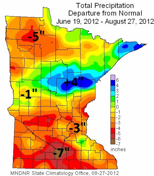
*
map above from the Minnesota Climatology Working Group shows rainfall
departure from normal from June 19 to August 27. The Duluth area is
running a 4" surplus since mid-June, while Mankato is experiencing a 7"
rainfall deficit.
"Dear Paul Douglas...Tell them! 2013 is going to be worse than 2012! And 2014 is going to be worse than 2013! The only question is: will they be somewhat worse, or will they be a lot worse?" - J Drumke. Ph.D. Ecology, Superior WI.
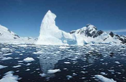
Arctic Sea Ice Will Vanish Within 3 Years, Says Expert. Some troubling predictions in this article at scotsman.com; here's an excerpt: "ARCTIC sea ice has melted to a record low, confirming experts’ fears about the “devastating” impact of climate change on the planet. Figures published yesterday from the National Snow and Ice Data Centre (NSIDC), in the United States, reveal that sea ice in the Arctic has dropped to its lowest level since satellite recording started 30 years ago. It is the sixth year in a row that a new record low has been recorded, following consecutively worsening melts first identified in 2007. There is now 40 per cent less sea ice in the polar region than the average levels recorded between 1979 and 2000. With melting season still not over, concerns are growing that in a few years there will be no summer sea ice at all – spelling disaster for wildlife such as polar bears, which rely on ice to hunt."
Colorado's Climate - Changes Coming? Here's an excerpt of a denverchannel.com post, from a TV meteorologist I have a lot of respect for, Mike Nelson in Denver. He too is being attacked for being pro-science, and having the temerity to actually believe the climate scientists when it comes to AGW. Here is a portion of a recent post on climate change impacting Colorado's day to day weather patterns: ".....I address this topic at some peril! In many ways, the job description for the TV "Weathercaster" is to simply be the nice friendly person that tells you what the high was, how much rain will fall and what to expect next weekend. I have found that, especially in recent years, broaching the topic of GLOBAL WARMING can stir up deep emotions within viewers and can bring some rather tough responses via e-mail and Facebook.Over the course of time, I have been called many different things while talking and writing about this subject. From courageous to foolish, to "the Pied Piper of Anti-Science"! I appreciate the fact that my viewers have many differing views and opinions on many issues and climate change is one topic that seems to bring a strong reaction."
Here's a Facebook post from Greg Fishel, one of my oldest friends, the Chief Meteorologist at WRAL-TV in Raleigh, North Carolina. He's been there a long time, a true fixture in the Carolinas. 5 years ago he was very skeptical about climate change, but after taking a closer look at the data, the peer-reviewed science, he changed his mind. Here is what he wrote: "
· - Completely
understand Isaac is the big story, but wanted to get this out there. Just
returned from the AMS Broadcast Conference/Short Course in Boston. One of the
elements of the short course was a panel discussion on Climate Change with Dr.
Kevin Trenberth of NCAR, Dr. Kerry Emanuel of MIT, and Dr. John Abraham of the
Climate Science Rapid Response Team. First of all, there is no way that any
rational human being sitting in that room could accuse any of these 3 gentlemen
of being extremists. In fact, the pro-AGW folks that are not scientists are
doing these researchers a grave disservice by making them look extreme. These
are responsible researchers who are dedicated to the principles of the
scientific method. They are skeptical by nature, and it is that skepticism that
insures the conclusions they reach are based on fact and not emotion or
politics. What really disturbed me is the number of meteorologists I know that
are hard core skeptics, and... either
chose not to attend the short course, or if they did never once raised their
hand to confront the climate scientists. Until we abandon this "junior
high dance" mentality where one side is locked to one side of the room,
and the other side to the other side of the room, nothing gets resolved. To be
fair, the AMS didn't exactly make it cheap to attend the short course, so that
may have played a role in increasing the number of no-shows. I know what it is
to avoid conflict-I have done it most of my life, but if I do that, I have no
right to bad mouth the people I am avoiding. Everybody involved in this debate
needs to grow up, stop the name calling, and look for opportunities to engage
in conversations with folks they don't agree with. That's the mature way to do
it. It wasn't that long ago that I was one of the name callers. When I realized
that I was only looking for information that supported what I already believed,
I concluded that I was not being loyal to the scientific method. I didn't jump
to the other extreme, but rather made a commitment to try my very best to be
objective and open minded. By simply doing that, some said I had caved. Really?
Do we want to live in a binary society where you're either a zero or a one?
Personally, I think the spectrum is still there-we just need to have the guts
to explore it.
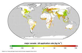
Study Offers New Hope For Increasing Global Food Production, Reducing Environmental Impact of Agriculture. Here's a fascinating new paper from the University of Minnesota's Institute On The Environment - an excerpt: "Can we have enough to eat and a healthy environment, too? Yes—if we’re smart about it, suggests a study published in Nature this week by a team of researchers from the University of Minnesota and McGill University in Montreal. Global demand for food is expected to double by 2050 due to population growth and increased standards of living. To meet this demand, it is often assumed we will need to expand the environmental burden of agriculture. The paper, based on analysis of agricultural data gathered from around the world, offers hope that with more strategic use of fertilizer and water, we could not only dramatically boost global crop yield, but also reduce the adverse environmental impact of agriculture."
Why Does The GOP Still Ignore Climate Science? Yes, I'm a (rare) Republican who acknowledges the obvious: 90 trillion tons of greenhouse gases in the last 50 years (EPA estimate) may actually be having some effect on our global climate. Here's an excerpt of a story at bostonmagazine.com: "...But instead of acknowledging the fact that climate change exists and is responsible for the increasingweatherextremes—more hurricanes, more snowstorms, more tornadoes, more scorching-drought-filled summers—the Republicans continue to not just ignore climate change, but mock President Obama for being concerned about it. The only mention of climate change in the entire 2012 Republican Platform isn’t in the environmental/energy section, but in a critique of Obama’s national security strategy:
“The current Administration’s most recent National Security Strategy reflects the extreme elements in its liberal domestic coalition…the strategy subordinates our national security interests to environmental, energy, and international health issues, and elevates “climate change” to the level of a “severe threat” equivalent to foreign aggression.”Why would the Obama administration consider climate change to be a severe threat? Well, maybe it’s because the military and the Defense Department are really worried about it. Consider the Department of Defense’s Quadrennial Defense Review Report, which notes that:
“While climate change alone does not cause conflict, it may act as an accelerant of instability or conflict, placing a burden to respond on civilian institutions and militaries around the world. In addition, extreme weather events may lead to increased demands for defense support to civil authorities for humanitarian assistance or disaster response both within the United States and overseas.”Photo credit above: NASA.
No comments:
Post a Comment