By Paul Douglas
Unlike tornadoes, which last 5-30 minutes, impacting a few square miles, hurricanes swirl for days, even weeks - often affecting millions. NOAA satellites monitor these vast, Texas-size storms. Before the first Tiros-1 weather satellite (1960) forecasters relied on ship reports!
The last time Tampa was hit by a major hurricane was 1921. Since then the population has topped 2 million; most residents have never experienced a major hurricane. “SLOSH” models show a worst-case storm pushing 14-18 feet of water into Tampa Bay. The odds of this are slim.
The GFS model shows Isaac tracking up Florida's west coast Monday, focusing its fury from Sanibel & Siesta Key to Tampa. But the ECMWF has been consistent, taking Isaac into the Gulf of Mexico, with a strike near Louisiana by midweek. Encourage your friends & family from Houston to Miami to pay attention.
Isaac does put our T-storm risk into perspective. Hit the fair around midday; T-storms are likely tonight, again Saturday. The stickies are back. Dew points reach the 60s Friday with a high near 90 - a string of 80s next week.
And Isaac? It's been 7 years since a major hurricane hit the USA. Statistically we are overdue.
___________________________________________________________________________________
Todd's Conservation MN Outlook for the Twin Cities and all of Minnesota
THURSDAY: State Fair kicks off! Soggy start. Sticky with a chance of afternoon T-storms. Winds: SSE 5-15mph. Dew point: 64. High: 85
THURSDAY NIGHT: Lingering shower or storm, drifting into Wisconsin overnight. Low: 69
FRIDAY: Lingering shower early? Warm, hazy PM sun . Dew point: 66. High: 88
SATURDAY: A few drips early? Fading PM sunshine with isolated T-showers late. Low: 66. High: 85
SUNDAY: Stikcy start, looking better by late afternoon. Low: 66. High: 82
MONDAY: Nice day at the Fair! Comfortable sunshine. Low: 63. High: 82
TUESDAY: Slight chance of thunder. Low: 63. High: 83
WEDNESDAY: Storm system blows through with a slight chance of rain/thunder. Low: 66. High: 81.
___________________________________________________________________________________________
Thursday, August 22nd, 2012
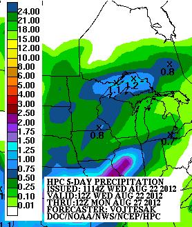
Just as the Minnesota State Fair kicks
off, scattered showers and storm potential enters the picture. NOAA's
HPC 5 day rainfall forecast suggests nearly 1" of rain throughout parts
of the state as two storm systems move through the Upper Mississippi
Valley. The first rolls through Wed./Thurs. and the second moves in by
Saturday.
MN State Fair App
Don't forget to download the MN State Fair app for your smart phone... it's FREE, but not on a stick!


Fair Food
I'm a BIG fan of the Fair food...
I typically try ONE new thing every year. This might be the ticket this
year... The Yosemite SAMwich!! Sounds like a artery blocker waiting to
happen, but I'll try it!
Yosemite SAMwich
Spicy taco meat on a sesame seed bun with BBQ sauce, nacho cheese sauce, bacon bits and crispy onion tangles.

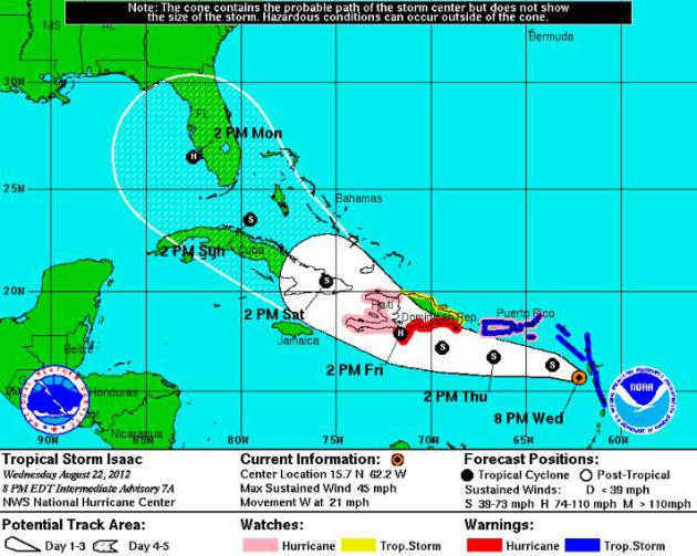
Sir Isaac
Isaac continues to drift west through
the Leeward and Windward Islands with further intensification expected
over the coming days. The more concerning part about Isaac in the near
future throughout the Caribbean is heavy rain potential and flooding.
Longer term is the potential for a strong hurricane nearing the
southeastern tip of the U.S.

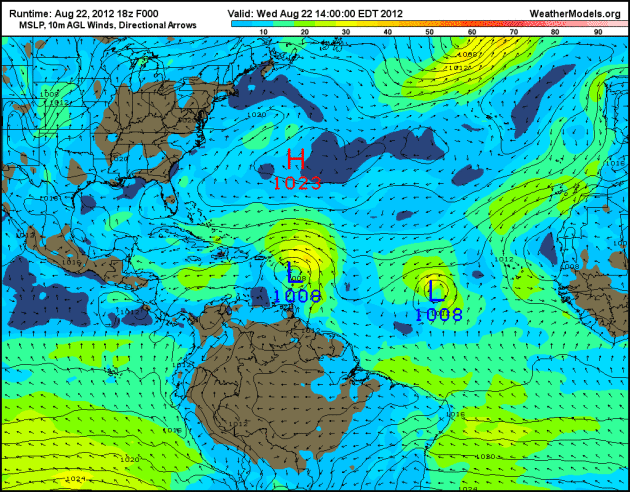
Active Atlantic
Not only are we keeping a close eye on
Isaac, but Joyce may develop on his heels. Both storms are drifting
west! It could be an active next several days/weeks.

Here’s Another Look…
The two counterclockwise areas of
circulation drifting west across the Tropical Atlantic region are the
aforementioned storms above.

Focusing on Isaac
DISCUSSION AND 48-HOUR OUTLOOK
------------------------------
AT 800 PM AST...0000 UTC...THE CENTER OF TROPICAL STORM ISAAC WAS
LOCATED NEAR LATITUDE 15.7 NORTH...LONGITUDE 62.2 WEST.  ISAAC IS
MOVING TOWARD THE WEST NEAR 21 MPH...33 KM/H...AND THIS GENERAL
MOTION IS EXPECTED TO CONTINUE FOR THE NEXT COUPLE OF DAYS.  ON THE
FORECAST TRACK...THE CENTER OF ISAAC SHOULD MOVE AWAY FROM THE
LEEWARD ISLANDS DURING THE NEXT FEW HOURS...PASS NEAR OR SOUTH
OF THE VIRGIN ISLANDS AND PUERTO RICO ON THURSDAY...AND APPROACH
THE DOMINICAN REPUBLIC THURSDAY NIGHT AND FRIDAY.
Spaghetti Plot
With spaghetti plots becoming a more
frequent visitor to my weather blogs/shows… I actually got hungry for
spaghetti and made it for dinner! NERD!!
A spaghetti plot refers to the plots of
SEVERAL different model runs and at different times. It can get
confusing, but keep in mind they all use their own sets of
data/calculations/times/variables to come up with their solutions. The
reason why it’s called a spaghetti plot is because it looks like a bunch
of different colored spaghetti noodles!
The models can either be “On to
Something” or “On Something” – We want consistency and conformity in
every model… For now, the consensus is a forecast track toward Florida
by late weekend/early next week.
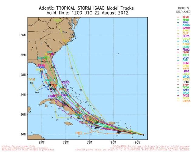
Watch the Plots Yourself!
Thanks to umw.edu and googlemaps you get interactive with the spaghetti plots!

Just One Model Solution… The GFS
This particular model (18Z GFS) suggests a strong storm sliding just west of the Gulf Coast
of Florida. This would indicate significantly stronger wind/heavy
rain/storm surge for the Keys, Ft. Myers, Tampa, St. Pete…
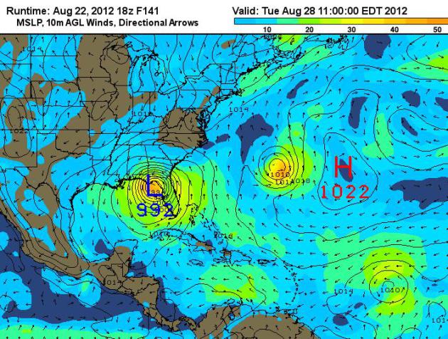
One Week From Today… GFS Solution
According to the 18Z GFS model, it puts
Isaac just northwest of Tampa, FL as a 992mb storm, but nowhere near the
record low pressure set by Hurricane Wilma set in October 2005.
Hurricane Wilma in October 2005
National Oceanographic and
Atmospheric Administration (NOAA) aircraft measured a record-low air
pressure of 882 millibars in the center of Hurricane Wilma, making it
the most intense hurricane ever observed in the Atlantic basin. Wilma
also broke records for the fastest development of a storm, going from
tropical storm status to Category 5 hurricane in less than 24 hours.

RNC Fearing Isaac?
Interestingly, the Republican National
Convention falls next weeks in Tampa, FL (August 27th-30). Officials
say they already have plans in place in case Isaac threatens Tampa…
“TAMPA –
Emergency management officials are keeping watch on a tropical storm that could be swirling toward Florida during the Republican National Convention.
If the tropical disturbance churns out thunderstorms or becomes a hurricane, officials say they will follow standard emergency procedures for shelter and evacuation despite the additional 50,000 visitors and 15,000 protesters expected to be in town for the convention.”

Florida Already Seeing Heavy Rain
Thanks to @mattlopez313 for the soggy
picture below out of Florida. A slow moving front across parts of
Florida have allowed of several days of heavy rain already.

HPC 5 Day Rainfall Forecast
NOAA’s HPC 5 Day rainfall forecast still
suggests 1″ to 2″ of rain possible for central and northern Florida
with heavier amounts expected across the southern tip of Florida as
Isaac nears by late weekend/early next week.

Thanks for checking in on this Wednesday, have a great rest of your week!
Don’t forget to follow me on Twitter @TNelsonWNTV

No comments:
Post a Comment