83 F. high in the Twin Cities Monday.
74 F. average high for September 10.
89 F. high on September 10, 2011.
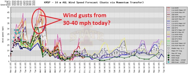
40 mph wind gusts possible over southern Minnesota today.
Red Flag Warning posted, meaning a high risk of rapidly-spreading brushfires. Details below.
31. Today should be the 31st day this year at or above 90 F. in the Twin Cities, the most since 1988 (44).
Last 90 of 2012? Who knows. The way this year is
going we may see another 90 in mid-October. I don't see any more 90+
readings looking out 2 weeks though. The NAM models have lost their
digital minds, predicting upper 90s to near 100. I think that's a
stretch, but low to mid 90s seems reasonable. Wrong word for September
11.
Shorts & Jackets. Typical September fare: A/C
one day, a week later rummaging around for jackets and sweat shirts.
Heat peaks today, highs in the upper 60s to near 70 the latter half of
the week before recovering into the 70s over the weekend. The
ECMWF (European) model above shows highs in the 50s by Monday and
Tuesday of next week.
0 Oklahoma tornadoes from June thru August, one
small silver lining to a persistent drought. No, you can't get tornadoes
under a blazing 100-degree sun. The only other time this has happened
during meteorological summer: 2003. Source:
Oklahoma Mesonet.
"
All genuine learning is frightening. It’s new, and therefore unknown, at first, and we’re naturally frightened of the unknown.” - Tom T. Tashiro, in an important post from ABC News journalist Bill Blakemore, below.
"...
As a Republican business owner, entrepreneur, meteorologist
and father of two upbeat, optimistic boys, I may not fit the stereotype
of a "global warming alarmist." I'm an Evangelical Christian. I'm
enthusiastic about streamlining government and letting the markets work.
But unlike some, I see no inherent struggle between my faith and the
ability of science to improve our understanding of the world. The
Creator gave me a brain, to think and reason, and react to facts on the
ground. And I'm disillusioned, because some in my party are
pro-science-denial, and on the wrong side of history..." - excerpt of a story I wrote for Huffington Post; details below.
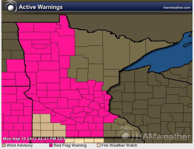
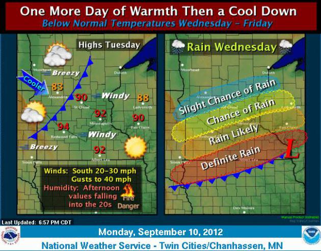
Extreme Fire Danger. A "Red Flag Warning" is posted
for much of Minnesota today, meaning a high threat of brushfires, which
may move quickly once started (due to 35 mph wind gusts). The
combination of low humidity, high winds, bright sun, low 90s and
lingering drought has created a ripe environment for rapidly-moving
fires.
Peak Wind Gusts. Models show south winds of 30+, a
few models showing winds blowing as hard as 40-45 mph. from the south.
That's why forecasters are so concerned about today's fire risk.
Graphic: Iowa State. Go Cyclones!
Weather Story. Welcome to the 31st day of 90+ heat
this year in the Twin Cities. A strong pressure gradient will whip up
southerly winds gusting over 30-35 mph. at times. Combined with dew
points in the 40s, bright sun and a lingering drought, conditions will
be ripe for brushfires to start, and spread rapidly. A cooler front
pushes thru late tonight, a wavel of low pressure rippling along the
front will spark a period of rain over southern Minnesota Wednesday,
heaviest south/west of the Twin Cities.
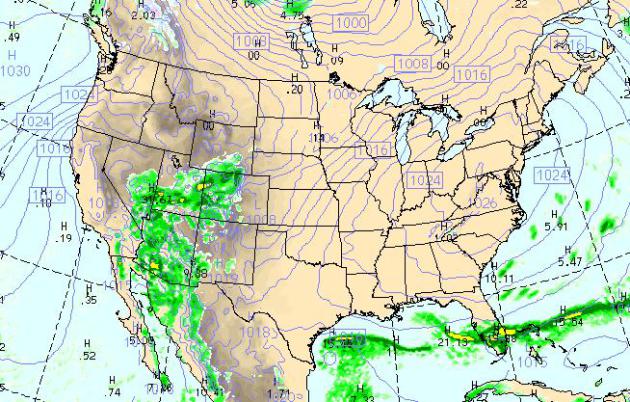
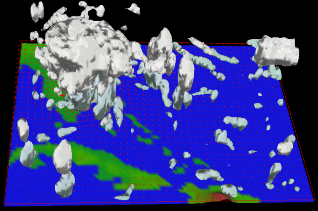
Today's Map. The WRF, valid 4 pm central time, shows
a quiet Tuesday across most of the USA. A tight pressure gradient whips
up strong winds over the Midwest, the east coast cools off with heavy
T-storms limited to south Florida. Monsoon T-storms pop up over the
Desert Southwest, no relief from the heat (or brushfires) over the
Pacific Northwest.
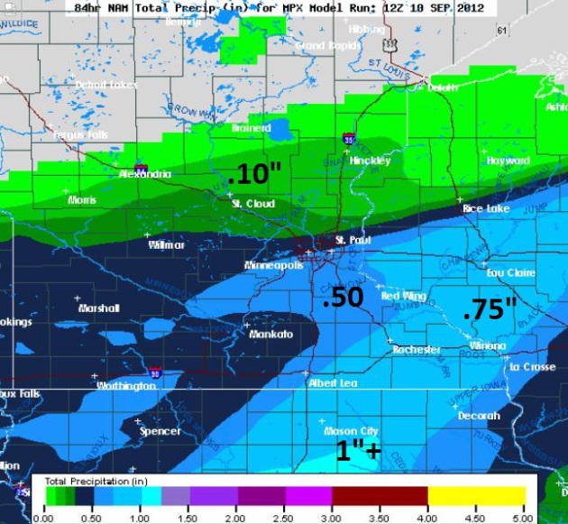
Brushed By Rain. It's not nearly enough, but we're
in no position to bargain with Mother Nature. A cooler front arrives
tonight, a wave of low pressure rippling east along this front throws up
a shield of stratiform rain Wednesday into early Thursday, some .50"+
amounts south of the MSP metro, closer to 1" near Des Moines. Little
rain is expected north of St. Cloud.
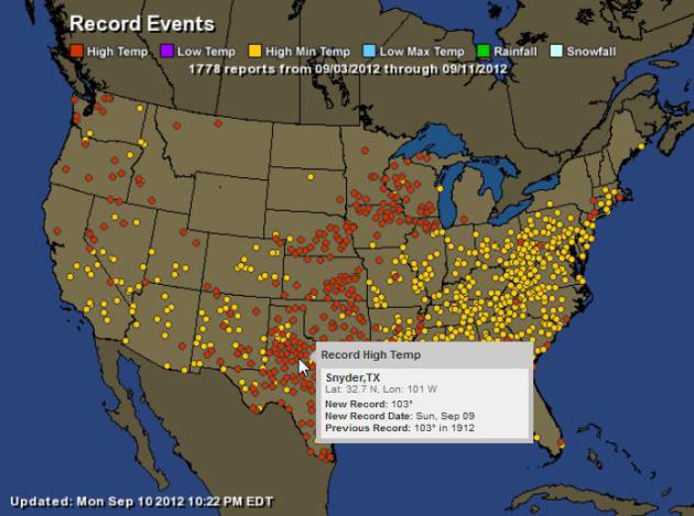
Summer Hangover. At some point (next week?) it will
cool off significantly, but summer heat is spilling over into
mid-September; 1,778 warm weather records in the last week. For an
interactive map with details for every record high (red dots) and record
warm nighttime low (yellow dot) click here; courtesy of
Ham Weather.
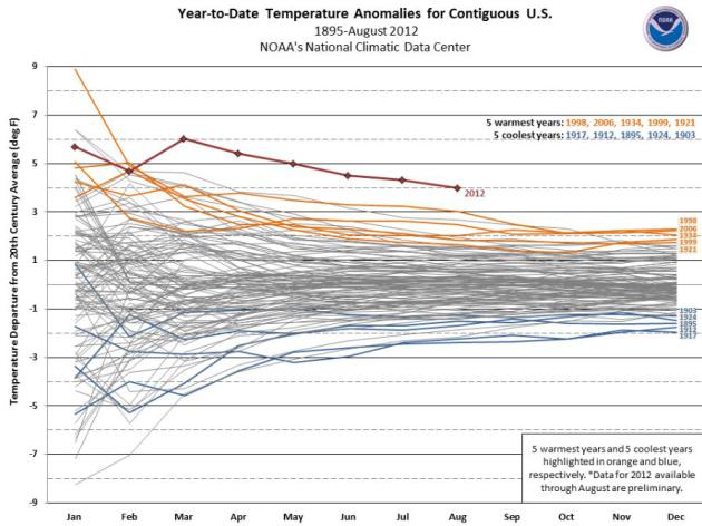
2012: A Year Like No Other. Data from
NOAA NCDC
shows 2012 temperature trends considerably warmer than previous
record-warm years, like 1998 and 2006. What makes the numbers even more
extraordinary was the fact that a La Nina cooling phase was still in
place thru May, which should have had a cooling effect for the
contiguous USA. It didn't quite work out that way.
Newfoundland On Watch As Tropical Storm Leslie Approaches. The very latest news (and video) from Canada's
CTV News; here's an excerpt: "
Tropical
storm and hurricane watches are in effect for parts of coastal
Newfoundland as the island braces for the arrival of tropical storm
Leslie. The storm is currently centred in the Atlantic, having buffeted
Bermuda Sunday with strong winds but little damage. It continues to
churn toward Atlantic Canada, and is expected to make landfall in
Newfoundland Tuesday morning, according to the most recent statement
from the U.S. National Hurricane Center...
Leslie will arrive
almost two years after Hurricane Igor pounded Newfoundland as a
Category 1 hurricane. It dumped 200 millimetres of rain, caused $200
million in damage and was blamed for the death of one man."
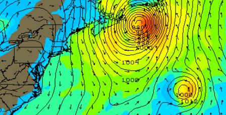
Landfall. The GFS model above (valid 2 am today)
brought "Leslie" ashore as a strong tropical storm or minimal hurricane
near Prince Edward Island, Canada. As of late last night sustained winds
were 70 mph - Leslie still capable of a storm surge of 4-8 feet to the
right/east of where the core of the storm comes ashore.
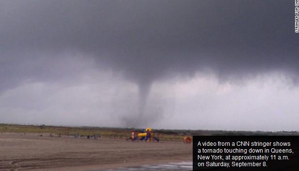
Two Tornadoes Hit New York City As Severe Weather Lashes Area. More on Saturday's severe weather outbreak across the Northeast from
CNN: "
Severe
weather barreled across the Northeast and mid-Atlantic on Saturday as a
powerful cold front brought heavy rain, high winds and at least one
tornado into a beachfront neighborhood of New York City. A waterspout
with winds up to 70 mph churned onshore and turned into a tornado
toward Breezy Point, officials said, a Queens neighborhood on the
western edge of the Rockaway peninsula. Amateur video captured images
of the twister spiraling a mixture of sand and debris, which was
largely flung onto a nearby baseball field, according to Ross Dickman, a
National Weather Service spokesman."
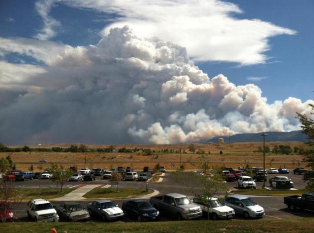
Photo Of The Day. Elliot Ramage, a former co-worker
of WeatherNation TV meteorologist Aaron Shaffer, shared this photo from
the Gateway Building at Casper College, in Casper, Wyoming. This one
image sums up (for me) the magnitude of the blaze outside of Casper.
Amazing.
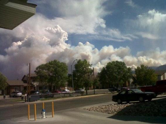
Another Perspective Of The Casper Blaze. Details from Brandi Southworth and the
WeatherNation TV Facebook page: "
Photo taken at 2:30 MT from my driveway in Casper, Wyoming! The smoke is filling the sky to the East!"
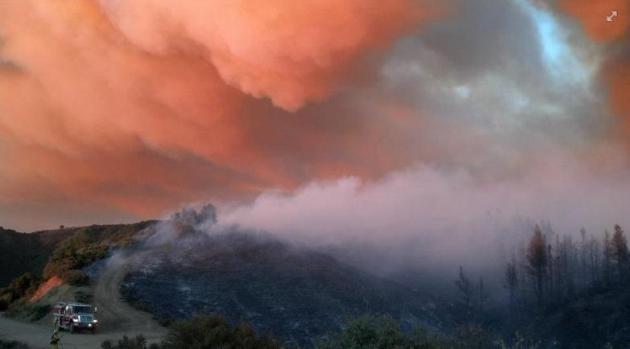
A Hellish Sight. Thanks to
Cal Fire for sharing this FB post and photo: "
The Scotts Fire burns on Cow Mountain in Lake County."
Current U.S. Fires.
This graphic is a real-time, interactive map, courtesy of
GlobalIncidentMap.com and
Inciweb.org.
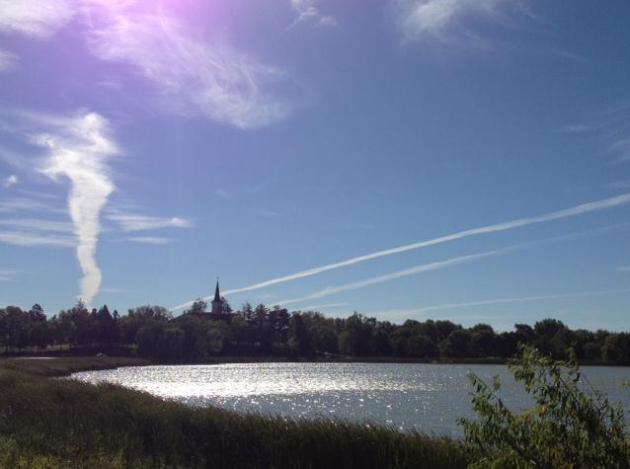
Honorable Mention: Sky-Scribble. When conditions
aloft are ripe, jet contrails can persist for a long period of time,
criss-crossing the sky like some giant version of tic-tac-toe.
WNTV meteorologist Bryan Karrick snapped this photo near Cologne,
Minnesota.
The Weatherman Is Not A Moron. Perhaps my favorite headline (ever), Nate Silver at
The New York Times
does a good job capturing the uncertainty of weather prediction, how
far we've come, and the limits to meteorological accuracy; here's an
excerpt: "...
These meteorologists are dealing with a small fraction of the 2.5 quintillion bytes
of information that, I.B.M. estimates, we generate each day. That’s
the equivalent of the entire printed collection of the Library of
Congress about three times per second. Google now accesses more than 20
billion Web pages a day; the processing speed of an iPad rivals that
of last generation’s most powerful supercomputers. All that information
ought to help us plan our lives and profitably predict the world’s
course. In 2008, Chris Anderson, the editor of Wired magazine, wrote
optimistically of the era of Big Data. So voluminous were our databases
and so powerful were our computers, he claimed, that there was no
longer much need for theory, or even the scientific method. At the
time, it was hard to disagree..."
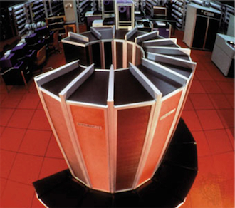
Supercomputers Aid Hurricane Prep. An interesting article from
computerworld.com; here's a snippet: "
Thanks
to advances in computing power and storm surge modeling systems,
Louisiana officials bracing for Hurricane Isaac's arrival last month
had more detailed data about the storm's potential impact than they had
seven years earlier when they were preparing for Hurricane Katrina.
Researchers at university supercomputing centers in Texas and Louisiana
used real-time data to inform emergency workers about what would
happen once the hurricane sent water into canals, levies and
neighborhoods. When Katrina hit in 2005, tools for modeling storm
surges, while good, were rudimentary compared with what's available
today. Back then, Louisiana used computer models with up to 300,000
"nodes," and it took six hours to run a simulation."
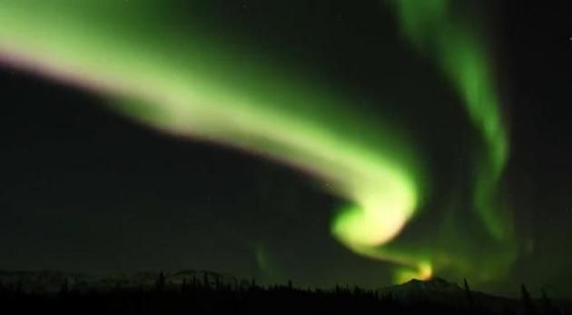
"Lights in Motion": Aurora Over Denali. This is a
remarkable time-lapse of the Northern Lights over Alaska; 8,000
individual images over the course of 3 months, courtesy of Jacob W.
Frank. The HD YouTube footage is
here.
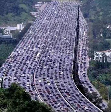
And You Thought I-494 Was Bad? We
only get a little taste here in Minnesota. If you've driven in Chicago
or Washington D.C. or (God-forbid) Los Angeles, you know how bad it can
be. The worst traffic jam ever? Hard to pin down firm statistics, but
the jam above in Beijing was 60 miles long, and lasted 11 days. Details
from
Google Plus.
The Fish Are Biting Again. It was a long, hot summer
for Minnesota anglers - record warmth keeping many of the big fish down
deep. Now that lake water temperatures are finally cooling off a bit,
some are having more luck. Tom Rusch from Minnesota caught this
good-looking Northern on Pelican (using night-bobbers) last weekend.
Maybe I have a shot. Then again...
Historic Weather on September 10 (source: local
Twin Cities NWS Office)
1980: 3.35 inches of rain fell in the St. Cloud Area.
1942: A line of thunderstorms raced across Minnesota at 70 mph, destroying 651 barns in a 30 mile wide, 180 mile long path.
1931: Summer still had its grip on Minnesota with
111 degrees at Beardsley.
1931: The daytime high in St. Cloud was 96 degrees.
1900:
The soggy remains of the Galveston Hurricane brings 6.65 inches of rain to St. Paul over two days.
1807: Thick smoky weather noted at Pembina.
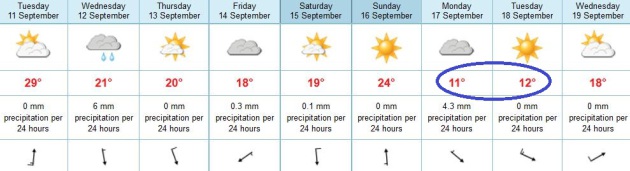
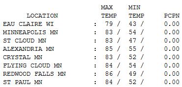
Summer Breeze. 83 F. for a high is fairly
impressive, considering the sun was as high in the sky yesterday as it
was on March 31. With gusty south winds and bright sun daytime highs
ranged from 79 at Eau Claire to 83 St. Cloud and Twin Cities, 86 at
Redwood Falls.
Paul's Conservation Minnesota Outlook for the Twin Cities and all of Minnesota:
TODAY: Red Flag Warning for high fire risk. Hot sun, gusty winds. Dew point: 47. Winds: S 25+. High: 92
TUESDAY NIGHT: Clouds increase, still breezy. Low: 65
WEDNESDAY: Cloudier, cooler. Late showers expected. High: 72
THURSDAY: Damp start, partial clearing. Low: 54. High: 68
FRIDAY: Partly sunny, comfortably cool. Low: 50. High: 69
SATURDAY: Plenty of mild sun. Low: 51. High: 73
SUNDAY: Hit the lake! Sunny and warmer. Low: 58. High: near 80
MONDAY: Last mild day in sight. Clouds increase. Low: 60. High: 79
31 and Holding?
Some years summer comes reluctantly, warm fronts
tire before reaching our lofty latitude. Not this year. A gusty south
wind lures the mercury into the 90s again this afternoon. Silver lining:
Gulf moisture isn't bubbling north this time; a dew point in the 40s
will make it feel reasonable out there much of the day.
The Grassland Fire Index reaches extreme
categories today for a convergence of factors: 90s, bright sun, low
humidity and winds gusting over 30 mph. Remember, Minnesota's biggest
fires have taken place in September and October, especially after hot,
dry summers.
Welcome to the 31st day this year at or above
90, the most since 1988 (44). This may be the last 90, but we'll see
more 80s, possibly by Sunday.
A forecast of 5 inches of rain over 3 days would qualify as "great weather" right above now.
Significant rain is possible from Des Moines to
Madison and Chicago the latter half of the week, but this next storm
will stay just south/east of Minnesota, brushing us with light rain late
Wednesday.
That old adage "when in a drought don't forecast rain" rings true.
A chilly front arrives next week; maybe one day in the 50s? Yes we're long overdue for a cool "correction".
Bring it.
Climate Stories....
Bloggers' Hall of Amnesia. A recent paper from
Stephan Lewandowsky, Winthrop Professor, School of Psychology at the
University of Western Australia has drawn a lot of of recent attention
(and the ire of climate denying bloggers everywhere). His research
suggests that conspiracy theoriests also tend to deny climate science.
Maybe we shouldn't be surprised. Here's an excerpt of his latest post at
shapingtomorrowsworld.org: "
The publication of my paper
on conspiracist ideation was met with nearly-instant accusations.
First out of the gate was the claim that I did not contact 5 “skeptic”
or “skeptic-leaning” blogs to link to the survey. I initially did not
release those names because I was concerned about the privacy issues
involved, as I explained here.
Because a release of names cannot be undone—whereas a delayed release
harms no one—I decided to seek guidance from various institutions,
foremost among them my own university, before deciding whether or not to
release those names. Shortly thereafter, the first of the 5 bloggers,
Mr McIntyre, found his misplaced email.
This leaves us with 4 bloggers whose identity had to remain
confidential until now. I am pleased to report that I received advice
from executives of the University of Western Australia earlier today,
that no legal or privacy issues or matters of research ethics are at
stake in this matter.
I am therefore now releasing the names of those 4 remaining bloggers:
- Dr Roger Pielke Jr (he replied to the initial contact)
- Mr Marc Morano (Climatedepot; he replied to the initial contact)
- Dr Roy Spencer (no reply)
- Mr Robert Ferguson (Science and Public Policy Institute, no reply)"
America Is Only Nation Where Climate Scientists Face Organized Harrassment. Australia comes in a close second, according to climate scientists I know and respect. Here's a snippet of a story from
InsideClimate News: "
The
harassment faced by U.S.-based climate scientists has been well
documented in the media—but not the harassment of scientists in Europe,
Canada or the rest of the world. That's because there hasn't been much
to report. While outspoken scientists of human-caused climate change in
the United States endure torrents of freedom of information requests,
hate mail and even death threats from skeptics, their counterparts
abroad have been free to do their work without fear."
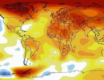
Image credit: "Map of global temperature anomalies." NASA.
Republican Meteorologist To Mitt Romney: My Top 10 Reasons For Republicans To Accept Reality On The Climate.
I'm waiting by the phone (does anyone do that anymore?) but so far no
call from Gov. Romney's campaign. My reason for writing this
article: the need to get past denial and climate conspiracies and come
up with pro-business solutions that lessen the risk, and put more
Americans back to work. This is America's Energy Moon-Shot, and I'm
waiting for Mr. Romney or President Obama to step up and connect the
dots. Solving this problem
will force us to innovate in ways that will ultimately expand the economy and GDP.
There is a smart way to do this. I'm no policy-wonk, I'm a bewildered
meteorologist, shaking my head at the weather maps every other day. We
passed "normal weather" a long time ago.
Denial-trolls will call me a RINO (Republican In Name Only). I could
care less. I'm saying what a number of TV meteorologists would like to
say, but can't, because of ignorant news directors, ratings pressures
and research concerns (every on-air "talent" is constantly tracked and
evaluated; their "Q Scores" help to determine if their contracts
ultimately get renewed). Antagonize too many viewers by including
climate science in your weathercast and you may not have a job for long. It's sad it's come to this, but that's reality.
20
years from now I hope to be able to look back and conclude that I did
everything in my power to help alert readers to the trends - and
implications for their families. If I can do that, then all the
name-calling will have been well worth it. Alarmist? If you're not yet
alarmed by what's going on, worldwide, you're not paying attention.
Here's an excerpt from my latest
Huffington Post article: "
During
the Republican National Convention in Tampa, climate change became a
punch line. "President Obama promised to begin to slow the rise of the
oceans and heal the planet" Mitt Romney said.
(Pause for polite laughter)
"My promise is to help you and your family."
All well and good. But denying climate change won't help any
American family or our fledgling economy. And looking at the world with
carbon-colored glasses, or using Solyndra as an excuse to snub
renewables and clean-tech, is not only short-sighted, but makes America
less competitive on the world stage. According to the World Economic Forum,
America's global competitiveness fell from 1st to 7th place since
2007. Should we just accept that most breakthrough energy technologies
are originating in China and Europe, where there is no more "debate"
about climate trends? Why is America still questioning the science?
For political entertainment? Something tells me Mother Nature may get
the last laugh...."
The Elephant We're All Inside. ABC journalist Bill
Blakemore has done some terrific reporting on climate change in recent
years. Is the media being too timid in its ongoing coverage? Will we
look back in 10 years at this time and think "too little, too late?"
Here's an excerpt from a
recent article: "
A
number of the world’s professional climate scientists are perplexed by
— and in some cases furious with — American news directors.
“Malpractice!” is typical of the charges this reporter has heard highly
respected climate experts level — privately, off the record — at my
professional colleagues over the past few years. Complaints include what
seems to the scientists a willful omission of overwhelming evidence
the new droughts and floods are worsened by man made global warming,
and unquestioning repetition, gullible at best, of transparent
anti-science propaganda credibly reported to be funded by fossil fuel
interests and anti-regulation allies. As scientific reports about the
speedy advance and devastating impacts of man made global warming have
grown steadily more alarming, surveys have shown most mainstream
American news organizations covering it less and less over the past two
years."
TV Forecasters: Connect Climate And Extreme Weather! The story from
Huffington Post - here's a clip: "
This
summer, as the melting Arctic turned into an hourglass marking the
time we have left to address climate change, it became obvious we have
reached that "Pearl Harbor moment" on global warming. Actually, it's
been more of a "Pearl Harbor year" -- unusually warm winter,
destructive wildfires out West, corn-killing drought in the Midwest,
record-breaking high temperatures, flooding from Hurricane Isaac. World
Resources International has compiled a mind-blowing timeline on this year's extreme weather and climate events...." File photo: Wikipedia.
Climate Change Expert Calls For Nuclear Power "Binge" To Avert Global Warming.
I have mixed feelings about nuclear, having grown up in the shadow of
TMI in Pennsylvania (I was 23 miles downwind during the disaster in
1979, our bags were packed, we were prepared to evacuate our home and
never return). But new generations of nuclear are safer. We still have
the waste problem to deal with, but now it's a matter of pick your
poison. Which energy source will do the least harm to the environment
long term? Here's a clip from a story at
The Guardian. "
A leading British academic has called for accelerated research into futuristic geo-engineering and a worldwide nuclear power
station "binge" to avoid runaway global warming. Peter Wadhams,
professor of ocean physics at Cambridge University, said both potential
solutions had inherent dangers but were now vital as time was running
out. "It is very, very depressing that politicians and the public are
attuned to the threat of climate change
even less than they were 20 years ago when Margaret Thatcher sounded
the alarm. CO2 levels are rising at a faster than exponential rate, and
yet politicians only want to take utterly trivial steps such as banning
plastic bags and building a few windfarms," he said."
Photo:
Wikipedia


No comments:
Post a Comment