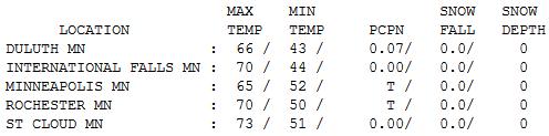
65 F. high in the Twin Cities yesterday.
58 F. average high for October 16.
59 F. high on October 16, 2011.
Trace of rain fell Tuesday morning.
.30" rain predicted for the metro area by Thursday evening. (NAM model).
60+ F. highs possible again by Sunday.
"...
The last time September temperatures were below that average
was 1976, and the last time any month was below that average was
February 1985, NOAA scientists said in a statement..." - from a Scientific American report below.
"...
63% of Obama voters say global warming is occurring mostly
because of human activity, compared to 18% of Romney voters, Pew found..."
"...
Eighty-five percent of Democrats believe there is solid
evidence of warming, up from 77 percent last year; 65 percent of
independents hold that view, up two percent from last year, while 48
percent of Republicans see solid evidence of warming, a five point
increase over last year and 13 points higher than in 2009..." - from a recent Pew poll reported at The Hill; details below.
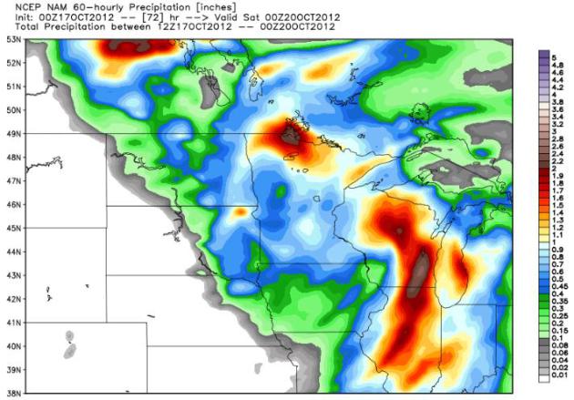
Yet Another Rainy No-Show. We just can't seem to buy
a storm. The drought is flavoring all weather now, and once again
rainfall amounts will (probably) be minimal over much of central and
southern Minnesota. The heaviest amounts predicted by NOAA NCEP's
NAM model is over far northern Minnesota, where some 1-2" amounts are
predicted.
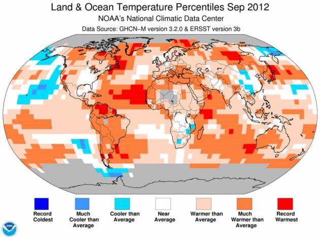
September Tied Global Heat Record. Details from
Scientific American; here's the introduction: "
Last
month tied for the warmest September in the global modern record,
scientists at the U.S. government's National Oceanic and Atmospheric
Administration reported on Monday. This September tied with the same
month in 2005 for the record. The land-and-sea global average
temperature was 60.21 F (15.67 C), or 1.21 F (.67 C) above the 20th
century average. In addition to being hottest since 1880, the month was
the 36th consecutive September and 331st consecutive month with a
global temperature above the 20th century average..."
Map credit above:
NOAA NCDC.
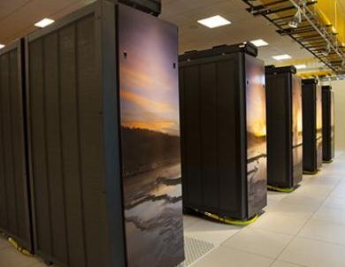
NCAR-Wyoming Supercomputing Center Opens. Details from
phys.org: "
Scientists
at the National Center for Atmospheric Research (NCAR) and universities
across the country are launching a series of initial scientific
projects on the center's flagship, a 1.5 petaflop IBM supercomputer
known as Yellowstone. These first projects focus on a wide range of
Earth science topics, from atmospheric disturtances to subterranean
faults, that will eventually help to improve predictions of tornadoes,
hurricanes, earthquakes, droughts, and other natural hazards..."
Photo credit above: "
This photo shows a handful of the
Yellowstone supercomputer's 100 racks. An iconic scene from its namesake
national park is feature mosaic-style ont he ends of each rack. The
image by Michael Medford, licensed to National Geographic, centers on
Fountain Geyser." Credit: UCAR. Photo by Carlye Calvin.
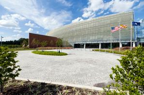
NOAA Opens New, Word-Class Weather And Climate Center. The new NOAA campus is opening up on the campus of the University of Maryland. Details from
NOAA: "
The
federal government today officially opens a new center that is the
backbone of weather and climate prediction for the nation. Acting
Secretary of Commerce Rebecca Blank, U.S. Senator Barbara Mikulski,
NOAA Adminstrator Jane Lubchenco and other federal and state officials
will gather for a ribbon-cutting ceremony at the new Center for Weather and Climate Prediction
on University of Maryland grounds to announce the new programs and
collaborations the facility will support. The 268,000 square-foot
building is home to more than 800 employees of NOAA’s Center for
Weather and Climate Prediction who provide the nation with a broad
range of environmental services – from predicting the hurricane season
and El Niño/La Niña to forecasting ocean currents and large-scale
rain and snow storms. Billions of earth observations from around the
world flow through environmental models, developed and managed in the
new building, that support the nation’s weather forecasts..."
Photo above: University of Maryland.
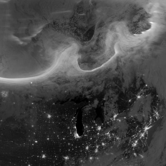
Amazing Aurora: Best Images From NASA's Suomi Satellite.
Wired.com has details on some of the most aurora images I've ever seen - here's a clip: "
Overnight
on October 4-5, 2012, a mass of energetic particles from the
atmosphere of the Sun were flung out into space, a phenomenon known as a
coronal mass ejection. Three days later, the storm from the Sun
stirred up the magnetic field around Earth and produced gorgeous
displays of northern lights. NASA satellites track such storms from
their origin to their crossing of interplanetary space to their arrival
in the atmosphere of Earth. Using the “day-night band” (DNB) of the
Visible Infrared Imaging Radiometer Suite (VIIRS), the Suomi National
Polar-orbiting Partnership (Suomi NPP) satellite acquired this view of
the aurora borealis early on the morning of October 8, 2012. The
northern lights stretch across Canada’s Quebec and Ontario provinces in
the image, and are part of the auroral oval that expanded to middle
latitudes because of a geomagnetic storm..."
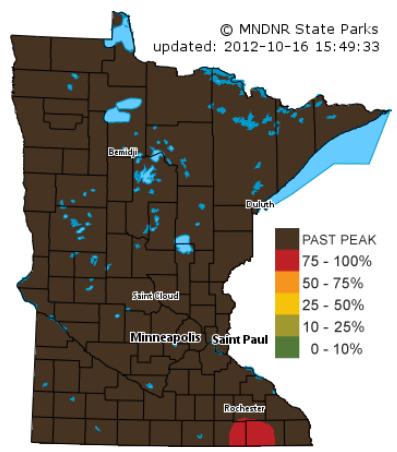
Climate Change Threatens Fall Colors. The story from
delmarvanow.com; here's the introduction: "
Fall
colors are arriving later and are fading more quickly because of
climate change, according to researchers. The climate-driven changes
are already visible in some forests in New England. Scientists worry
that leaf-peeping hotspots in Maryland also could eventually see duller
foliage and delays in the start of leaf season. “It (climate change)
certainly could have an impact here, as well,” said Saran Twombly, a
researcher at the National Science Foundation who studies the impact of
climate change on foliage. In Massachusetts’ Harvard Forest, data
collected by retired Harvard professor John O’Keefe suggests that
leaves are changing color four days later than they did in 1993..." Map:
Minnesota DNR.
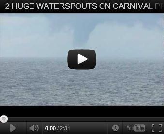 Waterspout!
 This is not what you expect to see on your relaxing cruise, a full-blown (large) waterspout. The video clip is on
YouTube; here's an explanation: "
While on our cruise to the Bahamas just of the coast of Florida 2
waterspouts formed behind our ship the CARNIVAL PRIDE. They were on the
water for almost 45 min - on Monday, Oct 8th 2012."
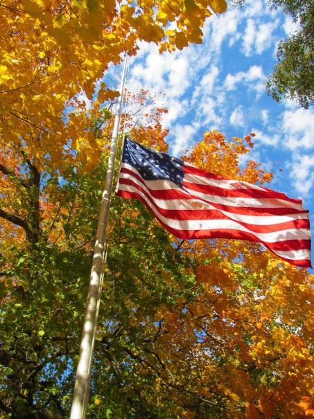 A Little Flag-Waving
. Here's a shot from the Harry S. Truman National Historical Site in Independence, Missouri.
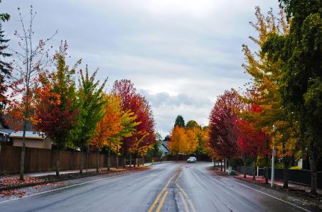 Postcard-Worthy
. Michael Trofimov snapped this
photo of fall color at Battle Ground, Washington on Tuesday
Microsoft Introduces XBox Music. A game-changer?
Possibly, but the smart thinking is that mobile is key to the future,
and there Pandora may be unbeatable. Details from
gizmag.com: "
As
big companies like Apple, Amazon, Google and Microsoft each compete to
gain supremacy in the “Post-PC” era, a killer ecosystem is thought key
to keeping users locked in to one particular platform. While we can
grant Microsoft’s gaming and business pedigree, its music services have
been lacking thus far, and to address this, the Redmond company is
launching a new music streaming service dubbed “Xbox Music,” which will
be available from Tuesday October 16 on Xbox 360, with further
platforms gaining support soon..."
 A Superb October Day.
 A gray start with a few
sprinkles gave way to blue sky, gentle breezes and lukewarm
temperatures. Highs ranged from 50 at Grand Marais to 65 in the Twin
Cities to 73 St. Cloud and 76 at Redwood Falls. Even International Falls
got in on the fun with a high of 70, more than 20 degrees above
average.
Paul's Conservation Minnesota Outlook for the Twin Cities and all of Minnesota (and the rest of the free world):
TODAY: Lot's of clouds - passing shower, gusty. Winds: W 15-25. High: 61 (falling by afternoon)
WEDNESDAY NIGHT: Partly to mostly cloudy. Low: 42
THURSDAY: A little light rain, heavier rain far western and northern MN. High: 48
FRIDAY: Showery rain, still cool & raw. Low: 39. High: 46
SATURDAY: Sun returns, warming up. Low: 40. High: near 60
SUNDAY: Fading sun, Indian Summer! Low: 45. High: 68
MONDAY: Mix of clouds and sun. Low: 49. High: 62
TUESDAY: More clouds, chance of a shower or two. Low: 40. High: 58
What a Year
I have to admit I'm enjoying this (fleeting)
quiet spell between hurricane and winter storm season. Especially in
light of the eye-popping year that is 2012.
NOAA NCDC reports that September was the
warmest, globally, on record - the 331st month in a row of global
temperatures warmer than the 20th century average. You have to go back
to Ronald Reagan's presidency to find a cooler than normal month. 2012
will almost certainly be the warmest year on record for the USA. A
1-in-500 year flood in Duluth gave way to pervasive drought by autumn.
Arctic ice reached the lowest level on record.
I'm reassured that both presidential candidates are taking this topic so seriously.
Cue the crickets.
The arrival of a cool smack sets off a passing
shower today, a better chance of light rain tomorrow and Friday -
heavier & steadier over northern and western Minnesota. Not the
soaking we need in the cities, but beggars can't be choosy.
As if on cue skies clear over the weekend; 60 is
posssible on Saturday - 70 F. not out of the question Sunday. Another
surge of 60s & 70s may leave us mildly dazed late next week. No sign
of snow. Give it a couple weeks.
We'll get our turn sometime in November.
Climate Stories...
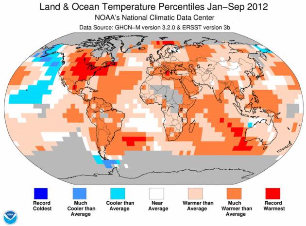
2012 Global Temperature Anomalies. There's a
misperception that "yes, North America had a hot year, but the rest of
the planet was unusually chilly." Really? I wouldn't reach that
conclusion looking at the map above, from statisticians at
NOAA NCDC.
Portions of Alaska and the northeastern Pacific were cooler than
average, but pretty much the entire planet is trending warmer. More
details from NCDC: "
The global land and ocean temperature for the
first nine months (January–September) of 2012 was 0.57°C (1.03°F) above
the 20th century average, ranking as the eighth warmest since records began in 1880. If this warmth continues through the end of the year, 2012 will surpass 2011 as the warmest La Niña year
since the Climate Predition Center began monitoring ENSO conditions in
1950. The January–September global land surface temperature ranked as
the sixth warmest such period on record. In the Northern Hemisphere,
where the majority of Earth's land masses are located, the year-to-date
temperature was the fourth warmest on record, largely attributed to
monthly record warmth during April, May, June, and July."
New Study Ties Hurricane Strength to Global Warming.
Climate Central has the story; here's a clip: "...
But
Alex Grinsted of the University of Copenhagen and his colleagues came
at the problem in an entirely different way. They looked not at
hurricanes themselves, but at the storm surges tropical storms drive before them as they come ashore, and surges have been reliably measured by devices known as tide gauges
all the way back to the 1920's. “Using surges as an indicator,”
Grinsted said in an interview, “we see an increase in all magnitudes of
storms when ocean temperatures are warmer.” As ocean temperatures have
risen inexorably higher in the general warming of the planet due to
human greenhouse-gas emissions, the scientists concluded, hurricane
numbers have moved upward as well. The implication: they’ll keep
increasing along with global temperatures unless emissions are cut
significantly..."
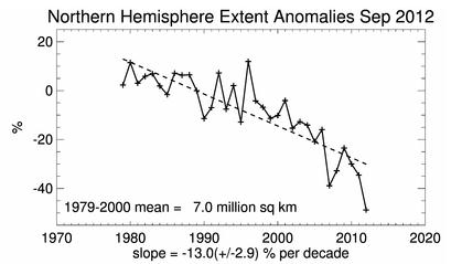
Arctic Sea Ice Falls To Lowest Extent On Record In September. Here's an excerpt of a recent
Wunderground post from Dr. Jeff Masters: "
Arctic sea ice extent during September reached its lowest extent in the 35-year satellite record, according to the National Snow and Ice Data Center
(NSIDC). As of October 14, Arctic sea extent had set a new record low
for the date every day since July 27. I have much more to say about
this year's extraordinary loss of Arctic sea ice in my September 20,
2012 post, Earth's attic is on fire: Arctic sea ice bottoms out at a new record low."
Graphic credit above: "
Arctic sea ice extent in September 2012 was the lowest measured, since satellite records began in 1979." Image credit: National Snow and Ice Data Center (NSIDC).
Arctic Summer Wind Shift May Increase Extreme Weather Events Across The Northern Hemisphere. The story from Current TV; here's an excerpt: "Changes
in summer Arctic wind patterns contribute not only to an unprecedented
loss of Arctic sea ice, but could also bring about shifts in North
American and European weather, according to a new NOAA-led study
published today in Geophysical Research Letters. A research team led by
James Overland, Ph.D., of NOAA’s Pacific Marine Environmental
Laboratory in Seattle, Wash., examined the wind patterns in the
subarctic in the early summer between 2007 and 2012 as compared to the
average for 1981 to 2010. They discovered that the previously normal
west-to-east flowing upper-level winds have been replaced by a more
north-south undulating, or wave-like pattern. This new wind pattern
transports warmer air into the Arctic and pushes Arctic air farther
south, and may influence the likelihood of persistent weather conditions
in the mid-latitudes..."
Poll: Belief In Global Warming Rising In Both Parties. Details from The Hill; here's an excerpt: "Growing
numbers of Democrats, Republicans and independent voters believe
global warming is occurring, but sharp partisan divides on the topic
remain, a new poll shows. The Pew Research Center poll released Monday
shows that 67 percent of Americans say there is solid evidence of
global warming. That’s four points higher than 2011 and 10 points
higher than 2009, although it remains well below the 77 percent who
held at view five years ago, according to Pew..."
Climate Heroes Crash Through Climate Silence. Thank God there are a few politicians who get it. Here's an excerpt from
getenergysmart.com: "
Consider …
- The planet has not seen a below-average temperature month since Ronnie Raygun’s presidency
- In both extent and quantity (extent x thickness), Arctic ice has set records this year — for lowest in recorded history.
- Weather extremes are demonstrating climate disruption around the globe — floods, droughts, severe storms, changed rain patterns, …
- In 2012, the United States has been hit hard by a wide range
of weather disasters (major heat waves, Derecho, drought, floods, wild
fires) that cannot be singularly attributed to climate disruption but cannot be seen/understood outside the context of global warming.
- For the United States, 2012 will almost certainly be the hottest year in temperature record."
Senator Bernie Sanders: To Battle Global Warming We Must Pick Clean Energy As A "Winner". Think Progress is hosting a letter from Senator Berie Sanders; here's an excerpt: "...
As
a member of both the Senate Energy and Environment committees, I am
working to stop the handouts to the fossil fuel industry. I have
introduced legislation called the End Polluter Welfare Act. Rep. Keith
Ellison filed the companion bill in the House of Representatives. Our
measure calls for the elimination for all subsidies to the oil, gas and
coal industries. Using the best available estimates from the
non-partisan Joint Committee on Taxation and other budget experts, we
found over $113 billion in federal subsidies will go to fossil fuel
corporations over the next 10 years alone. These subsidies benefit some
of the wealthiest corporations on the planet, including the five
largest oil corporations, which made a combined profit of $1 trillion
over the last decade. Unlike sustainable energy incentives, many of
these fossil fuel subsidies are written permanently into the tax code
by industry lobbyists, which means they never expire.
Let me give you just a few examples of outrageously strong federal support for Big Energy companies:
- BP, after committing one of the worst environmental
disasters in the modern history of America, was able to take a large
tax deduction on the money it spent cleaning up the oil spill in the
Gulf of Mexico.
- Coal companies are able to sign single-bid sweetheart leases
to mine on federal lands without paying fair value in royalties to the
taxpayers of this country...."
49 Of The Top 50 U.S. Employers Are Concerned About Battling Climate Change. Details from
triplepundit.com; here's a clip: "
In
this election year there have been ubiquitous declarations about the
concerns of America’s “job creators” which is understandable given the
high rate of unemployment. But what has been missing from the
discussion is that all but one of the top 50 employers in the U.S. is
concerned about battling climate change. An analysis of sustainability
reports and corporate websites of the Fortune 50
list of top U.S. employers reveals that 68 percent specifically cite
climate change as a key challenge, while everyone except Berkshire
Hathaway, a holding company, has strategies to lower their carbon
footprints and reduce greenhouse gas emissions. These are not just
passing references. Forty of the 50 companies issue annual
sustainability reports that clearly outline their mitigation plans and
report their annual progress..."
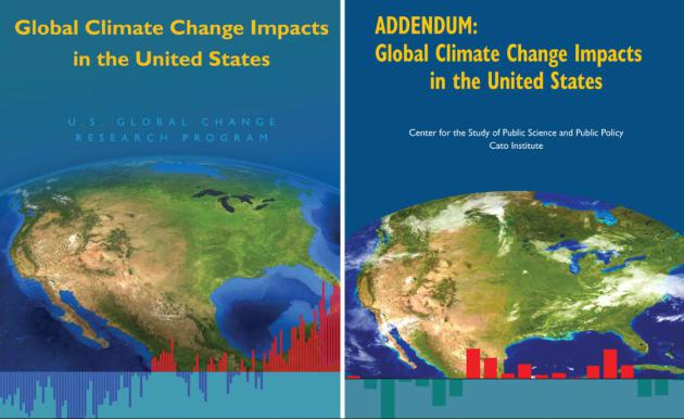
How Stupid Does Cato Institute Think Congress Is? Oh..Right. The story from
Climate Denial Crock Of The Week; here's an excerpt: "
A
seasoned DC observer flags this one: Apparently the (right wing “think”
tank) Cato Institute is set to release into the election campaign
circus a report titled “ADDENDUM: Global Climate Change Impacts in
the United States,” which mimics in layout and format the national
climate assessment report with the same title released by the White
House and the USGCRP in 2009. We have heard that this report was
coming, but apparently it is now to be publicly released and no doubt
is intended to be taken up and pushed by the denial machine..."


The best edge that wedding ceremony celebrity dresses fit retain the services of store can provide is definitely the cost. As the go well with is going to be rented just on the agreed day the rate will only charge a portion compared free shipping stores with acquiring it customised. Surely, this could advantage the few as they can redirect their budget on other specifics essential for the wedding.
ReplyDeletemichelleding: It brought with it quite a wedding dress shops
ReplyDeletehttp://michelleding.livejournal.com/15132.html
http://crosquare.com/blogs/entry/The-color-in-your-promenade-prom-suits
http://sunglasses1114.jigsy.com/entries/general/the-method-of-making-a-tattoo-online
http://dantecorde.blog.fc2.com/blog-entry-2.html
http://dantecorde.webs.com/
http://sunglasses1114.deviantart.com/journal/#/d5qke9w
http://hireoneveteran.com/index.php/blogs/4255/13946/you-possess-a-superb-position-su
http://20913093.blog.hexun.com/82456894_d.html
http://dantecorde.cocolog-nifty.com/blog/2013/01/exactly-what-ar.html
http://dantecorde.blog.co.uk/2013/01/06/the-chosen-shade-is-tattoo-online-has-not-changed-15400035/
http://blog.newdu.com/user1/17532/archives/2013/556248.shtml
http://en.netlog.com/hubailong/blog/blogid=16322980
http://jhjbafr.dhpreview.devhub.com/blog/1109863-guantee-that-the-jacket-on-the-wedding-suits/
http://costoflife.ning.com/profiles/blogs/in-a-single-cheap-flower-girl-dresses-working-day
http://blog.5u588.com/u/2140/archives/2013/30949.html
http://corde.hatenablog.com/entry/2013/01/06/110649
http://www.flixya.com/blog/5127630/The-colour-prom-suits-on-your-promenade-
http://hubailong88.blog.com/2013/01/06/the-tattoo-device-the-artist-uses-to-create-the-look/
http://2eyeglasses.blogspot.com/2013/01/this-may-be-your-desire-earth-any-free.html
http://ameblo.jp/corde/entry-11443170594.html
The limitation have been prevail over in the rather remarkable way. Every cheap wedding dresses one of the attire are featured on real daily life styles.It's also possible to enlarge a mother of bride dresses dress by clicking to the design featured having a selected dress.
ReplyDelete