27 F. high on Monday in the Twin Cities. Wind chill readings dipped into the low teens at times.
43 F. average high for November 12.
64 F. high on November 12, 2011.
Little or no precipitation thru next Monday.
1"+ rain possible the Wednesday before Thanksgiving? That's what the GFS model is suggesting, the ECMWF (European) keeps us dry with highs in the 50s.


1" of rain the Wednesday before Thanksgiving with showers tapering, possibly ending as flurries Thanksgiving Day? Long-range guidance is hinting at mostly rain from next week's storm, a cold rain at that. Details below.
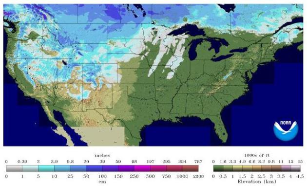
Looks Like Snow. As of yesterday 31.5% of the USA had some snow on the ground, according to NOAA, up from 2.1% on October 12, 2012.
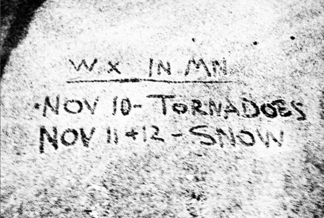
November 16, 1931: latest tornado ever observed in Minnesota, east of Maple Plains. Details here.
4 tornadoes reported in Minnesota during the month of November (2 of them were Saturday night). Details below.
Weather Whiplash
I may be showing up on Doppler the next few
weeks. I just got back from a two week Panama Canal cruise with my wife
and 82 year old dad - studying tropical weather - and the buffet table.
Burp.
69 F on Saturday, followed by 20s Sunday and a
howling wind of Siberian origin? This extreme cold front whipped up a
few small EF-0 tornadoes Saturday night near Burnsville & Eagan.
November twisters are exceedingly rare; with Saturday's outbreak there
have been only 4 tornadoes in November in modern-day records.
SPC had parts of southern Minnesota in a slight
risk, but there were no watches or warnings in effect when severe storms
spun up these small, brief tornadoes. What happened? The greater the
contrast in temperature the stronger the winds have to blow; and there
was just enough wind shear aloft to spin up small, brief, 75-80 mph
tornadoes.
With our expanding autumns maybe we shouldn't be
too surprised. Moral of the story: never let your guard down - when
skies turn threatening head for the basement, even in November.
Monday's icy coating of snow melts today; highs
in the 40s this week - near 50 (above!) next week. No big storms brewing
here into Thanksgiving, the way the maps are setting up. The biggest,
sloppiest storms continue to detour well south/east of Minnesota and
Wisconsin.
Yet another Nor'easter may cause (relatively
minor) coastal flooding along the east coast next week. Folks out east
just can't catch a break.
$50 billion in estimated damage in the New York City area alone from Sandy. Details from The New York Times.
Hurricane Sandy And The Disaster Preparedness Economy. The hottest gift for the holidays out east? Emergency generators. I'm not kidding. Forget jewelry and clothing - people want some assurance the power will stay on the next time a wild storm strikes. Here's an excerpt from The New York Times: "FOLKS here don’t wish disaster on their fellow Americans. They didn’t pray for Hurricane Sandy to come grinding up the East Coast, tearing lives apart and plunging millions into darkness. But the fact is, disasters are good business in Waukesha. And, lately, there have been a lot of disasters. This Milwaukee suburb, once known for its curative spring waters and, more recently, for being a Republican stronghold in a state that President Obama won on Election Day, happens to be the home of one of the largest makers of residential generators in the country. So when the lights go out in New York — or on the storm-savaged Jersey Shore or in tornado-hit Missouri or wherever — the orders come pouring in like a tidal surge..."
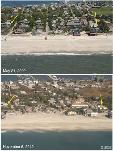
Photo credit above: "These photos provided by the U.S. Geological Survey showing Fire Island and Ocean Beach, N.Y. before and after Superstorm Sandy. The top photo was created May 21, 2009 and bottom photo taken Nov. 5, 2012." (AP Photo/U.S. Geological Service)
Sandy Victims Face Insurance Nightmare. CNN Money has the story - here's an excerpt: "When Roman and Marianna Bediner's Staten Island, N.Y., home was clobbered by Superstorm Sandy they took some comfort in knowing that it was insured. But a few days later, when they learned that their coverage would pay for only a fraction of the $75,000 to $100,000 needed to put the house back together again, that feeling evaporated. During the storm, Roman said the waters of Lower New York Bay rose by close to 11 feet, destroying all the walls, floors and ceilings -- not to mention the furniture and carpets -- on the first floor of his home. When the area flooded, the sewers backed up, filling the Bediners' ground floor with water that contained raw sewage and contaminating the home..."
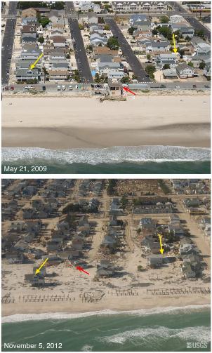
Photo credit above: "These photos provided by the U.S. Geological Survey show Seaside Heights, N.J. before and after Superstorm Sandy. The top photo was created May 21, 2009 and bottom photo taken Nov. 5, 2012." (AP Photo/U.S. Geological Service)
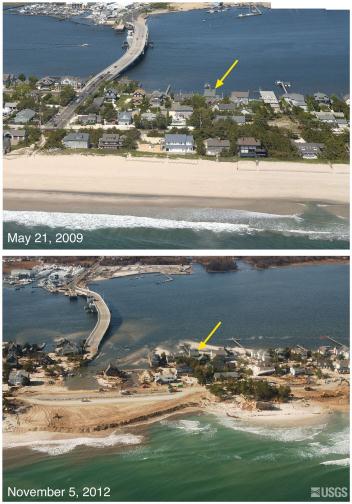
Hurricane Sandy Damage Amplified By Breakneck Development Of Coast. Some unpleasant trends are converging. At the same time storms are becoming more intense (and sea level is rising, by at least a foot since 1900 in the New York City area) coastal development has exploded. Who doesn't want to live near the water? Minnesota lakes are quite tame compared to what can nappen when a hurricane storm surge coincides with high tide and a full moon. More from Huffington Post: "...Given the size and power of the storm, much of the damage from the surge was inevitable. But perhaps not all. Some of the damage along low-lying coastal areas was the result of years of poor land-use decisions and the more immediate neglect of emergency preparations as Sandy gathered force, according to experts and a review of government data and independent studies. Authorities in New York and New Jersey simply allowed heavy development of at-risk coastal areas to continue largely unabated in recent decades, even as the potential for a massive storm surge in the region became increasingly clear. In the end, a pell-mell, decades-long rush to throw up housing and businesses along fragile and vulnerable coastlines trumped commonsense concerns about the wisdom of placing hundreds of thousands of closely huddled people in the path of potential cataclysms..."
Photo credit above: "These photos provided by the U.S. Geological Survey show Mantoloking, N.J. before and after Superstorm Sandy. The top photo was created May 21, 2009 and bottom photo taken Nov. 5, 2012." (AP Photo/US Geological Service)

"Ask Paul". Weather-related Q&A:
Hi Paul,
Read you all the time. Been a follower since 1988.
I’m very confused how a tornado could spin up,
touchdown in my back yard with absolutely no warning. In fact, I had
just concluded watching a local weather forecast about 10:20 on Sat.
night and there was no mention of strong wind, severe weather, nothing.
I just watched a rebroadcast of the weather segment again in case I
missed something. There were no sirens in Burnsville.
Everyone likes to pounce on the weathercasters when
they miss a forecast by a few degrees or ‘scattered showers’ hover over
their picnic, but this is serious stuff. How can this tornado have
possibly been missed by everyone on your field?
Regards, Mike Svec
Mike - I was on a cruise ship off the coast of
Florida Saturday night (I know, no excuse), but I'm trying to piece
together what happened. SPC had a slight risk into southern Minnesota
Saturday, but you're right: no watches or warnings were in effect when
the line of strong/severe storms arrived. Dew points were in the 40s and
low 50s, so moisture was somewhat limited, but with a 40 degree
temperature drop across the cold front there was ample wind shear to
spin up small, brief tornadoes (in 20-20 hindsight, of course). The
situation was marginal at best for tornadoes. And Doppler radar works
best on the big, supercell thunderstorms, not the small storms that
swept thru Saturday night. The resulting twisters were too small and
brief to create a noticeable "couplet" on Doppler.
Here's our new reality: technology is good, leaps
and bounds better than the radars we were using back in the 70s and 80s.
But it's not perfect, and never will be. There will be (rare) occasions
where tornadoes still spin up, with little or no warning. I want to
believe we'll catch the big (EF-2+) tornadoes, but the little ones? Very
difficult - they literally get lost in the sauce. When winds pick up
suddenly you head to the basement, or an interior room, even if it's
mid-November.
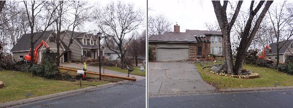
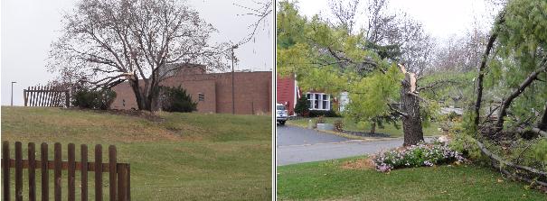
The Twin Cities NWS has more on the November 10 tornadoes in the south metro here. Some of the photos from near Burnsville and Eagan are below.
PRELIMINARY LOCAL STORM REPORT
NATIONAL WEATHER SERVICE TWIN CITIES/CHANHASSEN MN
630 PM CST SUN NOV 11 2012

..TIME...   ...EVENT...      ...CITY LOCATION...     ...LAT.LON...
..DATE...   ....MAG....      ..COUNTY LOCATION..ST.. ...SOURCE....
            ..REMARKS..

1058 PM     TORNADO          1 SW BURNSVILLE         44.75N 93.30W
11/10/2012  F0               DAKOTA             MN   NWS STORM SURVEY

            AN EF0 TORNADO SPUN UP JUST NORTHEAST OF THE INTERSECTION
            OF COUNTY ROAD 5 AND MCANDREWS RD AND TRACKED NORTHEAST
            TO JUST SOUTHWEST OF THE INTERSECTION OF BURNSVILLE PKWY
            AND HWY 11. NUMEROUS TREE AND POWER LINES WERE BLOWN DOWN
            ALONG THE PATH...SOME FELL ON HOUSES. A STOP SIGN WAS
            BENT ALL THE WAY TO THE GROUND AND A GRILL LID WAS FLOWN
            ABOUT 200 YDS NEAR NICOLLET JR HIGH SCHOOL. MAXIMUM WIND
            SPEEDS WERE 80 MPH.

1105 PM     TORNADO          2 NNW EAGAN             44.85N 93.18W
11/10/2012  F0               DAKOTA             MN   NWS STORM SURVEY

            A BRIEF EF0 TORNADO SPUN UP NEAR SKYLINE DRIVE EAST OF
            HWY 13 AND TRACKED NNE TO THE LOST SPUR GOLF COURSE JUST
            SOUTH OF I-494. NUMEROUS TREES WERE BLOWN DOWN AND
            EXHIBITED A CONVERGENT DAMAGE PATTERN. SOME TREES FELL
            ONTO HOUSES AND POWER LINES. OTHERWISE...LITTLE STRUCTUAL
            DAMAGE. ESTIMATED WINDS 75 MPH.
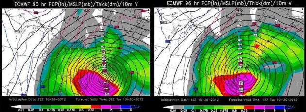
European Scientist: How We Improved Our Forecast Model, And How It's Reliant On U.S. Satellite Data. Eric Berger at The Houston Chronicle
has a good story about how the European (ECMWF) model is, in many
cases, better than the U.S. models. There's a good reason - how the
model is initialized, with new data fed into the model in real-time, as
it arrives, including satellite data from U.S. weather satellites.
Here's an excerpt: "...Physics is essential. In 2007 we made big changes to the model’s
physics, in particular the convection and clouds. This had quite a large
impact on our skill with tropical cyclones. Another essential element
is the way we use observations. This is what we call data assimilation,
the way we initialize our models. This is an area where I think we are
leading. The way we initialize our model using observations is probably
quite advanced compared to other centers. We make a very large use of
satellite data in particular, and particularly satellites from the
United States. We have a strong collaboration with NOAA. To have these
initial conditions accurate, and not accurate only in the vicinity of
the hurricane, or what is going to become a hurricane, but the large
scale flow around the hurricane is very important as well...."
* ECMWF model maps of Sandy's projected landfall courtesy of WSI Corporation.
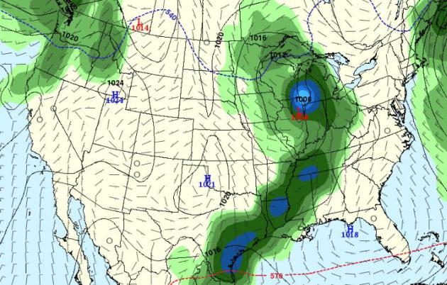
Thanksgiving Day Preview. Don't bet the farm based on a 9 day outlook, but the GFS is
suggesting a significant storm pushing across the Midwest and Great
Lakes next Wednesday. In fact the GFS model prints out over 1" of rain
the Wednesday before Thanksgiving in the Twin Cities - probably rain. I could see rain showers ending as snow showers or flurries on Thanksgiving Day. Stay tuned.
* Speaking of the superiority of the ECMWF model, the European keeps us dry into next Wednesday, a midweek warming trend luring the mercury into the 50s.
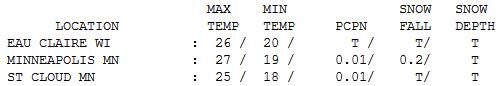
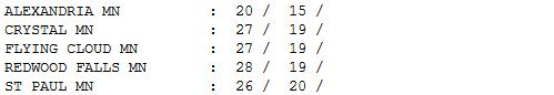
Instant Winter. What happened? 69
F. on Saturday, 20s yesterday and today. Like a cold slap across the
face. Or turning off a light switch. Monday highs ranged from 20 at
Alexandria to 25 St. Cloud, 27 Twin Cities and 28 Redwood Falls, nearly
20 degrees colder than average. How I long for average...
Paul's Conservation Minnesota Outlook for the Twin Cities and all of Minnesota
TODAY: Partly sunny, not as harsh. Winds: S 10 High: near 40
TUESDAY NIGHT: Clear to partly cloudy, not as cold. Low: 29
WEDNESDAY: Plenty of sun. I feel my toes again. High: 48
THURSDAY: Mix of clouds and sun. Low: 30. High: 47
FRIDAY: Bright sun, less wind. Low: 27. High: 46
SATURDAY: Blue sky, still storm-free. Low: 31. High: 45
SUNDAY: Patchy clouds, no travel headaches. Low: 33. High: 48
MONDAY: Intervals of sun, quiet. Low: 32. High: 46
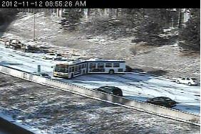
** photo of bus accident on I-35 Monday morning courtesy of MnDOT. More details on the icy start to Veterans Day:
- Windswept snow made for dicey driving conditions Monday morning around the Twin Cities area, including on a Minneapolis interstate, where a Metro Transit bus spun out late in the rush hour.
- The Route 114 bus had blocked all but the far left lane of southbound Interstate 35W between 26th and Lake streets, until its removal about 9:10, transit spokesman John Siqveland said. No injuries were reported. Only the driver was aboard the articulated bus.
- The bus jammed up traffic for about an hour.
- Fortunately for commuters, Monday is a holiday for many government workers in observance of Veterans Day. That means less traffic on the slick freeways and main thoroughfares. Even so, the bus mishap was one of several for motorists, who are getting their first reminder that wintry weather is drawing near.
Climate Stories....

Former UN Official Says Climate Report Will Shock Nations Into Action. The story from The Sydney Morning Herald; here's an excerpt: "THE next United Nations climate report will ''scare the wits out of
everyone'' and should provide the impetus needed for the world to
finally sign an agreement to tackle global warming, the former head of
the UN negotiations said. Yvo de Boer, the UN climate chief during the 2009 Copenhagen
climate change talks, said his conversations with scientists working on
the next report of the Intergovernmental Panel on Climate Change
suggested the findings would be shocking. "That report is going to scare the wits out of everyone,'' Mr
de Boer said in the only scheduled interview of his visit to
Australia. "I'm confident those scientific findings will create new
political momentum.''
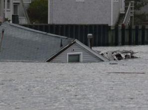
Photo credit above: "This house was floated off its foundation by Sandy. Fairfield Beach, CT." (Genevieve Reilly/Fairfield Citizen).

No comments:
Post a Comment