-2 F. low Thursday morning in the cities.
7 F. high yesterday at KMSP.
25 F. average high for January 31.
45 F. high on January 31, 2012
7 subzero nights so far this winter.
3 subzero nights all of last winter.
22.5 average number of nights below zero in the Twin Cities (latest 30 year average from NOAA).
Thaw likely by Thursday of next week.
Character-Building
Fun nuggets from my first book, "Prairie Skies"
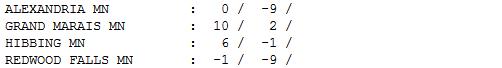
At -20 F motor oil becomes a thick gel. At -40 F exposed flesh freezes
within 1 minute. At -60 F your breath turns to ice crystals, which fall
to the ground. Trivia the Minnesota Chamber of Commerce is loathe to
share.
But wait, there's more. Leading automotive
experts claim that, on a bitter morning, moving your vehicle along
slowly, after 10 seconds, results in less stress on engine components
than gunning your engine for several minutes. And the only Minnesota
city to make the coveted "Top 100 Coldest Cities of the World" list?
Duluth.
Why? Lake Superior offers free air conditioning
much of the year. 36 of the 40 coldest cities are in Russia. I feel
warmer already.
We awake to some of the coldest readings of
winter but it won't be as bitter - as long - as last week. Alberta
Clippers drop a couple inches of snow next week; any thaw delayed until
late week. Most models shows a break from subzero the first half of
February. We'll see.
A rising sun angle usually doesn't compensate
for deep snow cover and long nights until late January or early
February, when temperatures finally start to budge.
An early spring? I doubt it.
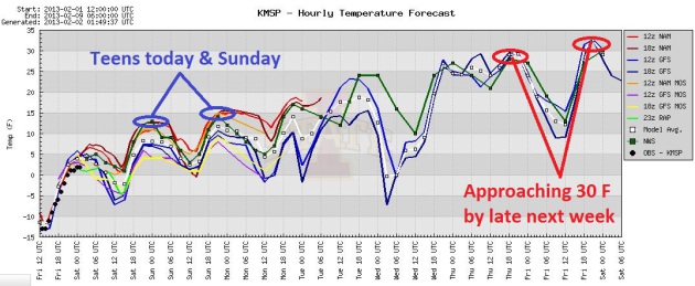
Stumbling Out Of The Deep Freeze. After a (very)
subzero start today, highs peak (wrong word) around 7 F. today, near 20
tomorrow, a good chance of low 30s by Thursday of next week. Slow,
steady progress. Graphic: Iowa State.
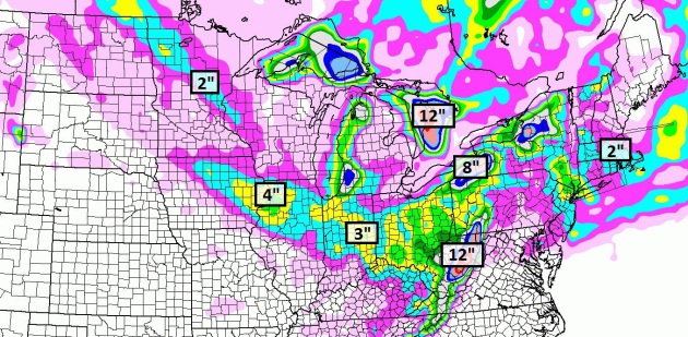
Snowfall By Late Sunday Night. Saturday's clipper
may drop an inch on the metro, a better chance of 1-2" from Grand Forks
to Crosslake to Taylors Falls. As much as 3-4" may fall near the Quad
Cities; the heaviest amounts downwind of the Great Lakes, based on
NAM guidance above.
A Few (Clipper) Inches Next Week. Saturday's clipper
may amount to little more than a coating, but ECMWF guidance shows a
few inches by the middle of next week from two more Alberta Clippers.
Not exactly The Big One, but snow lovers can't be too choosy right about
now. We may finally see freezing by next Thursday, low to mid 30s a
week from tomorrow. Won't that be nice.
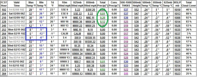
February? Better. The GFS is hinting at one night
near or below zero around Feb. 11, otherwise highs mostly in the 20s and
30s. A few more inches of snow next weekend (Feb. 9-10)?? I'll believe
it when I see it. Until winds aloft howl from Texas or New Mexico, we'll
have to depend on a series of Alberta Clippers for dribs and drabs of
snow.
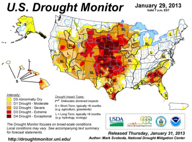
A Very Stubborn Drought. Here's the latest
U.S. Drought Monitor,
showing "exceptional drought" conditions from South Dakota, Wyoming and
Nebraska southward to Oklahoma and parts of Texas, another pocket of
very dry conditions over Georgia and South Carolina. Here's an overview
for the Midwest: "
There was some late period precipitation across
northeastern Iowa, northern Illinois and southern Wisconsin this past
week, but given the deficits, lack of impacts and frozen top soils, it
isn’t enough to move the drought off its mark, so status quo is the
word this week."
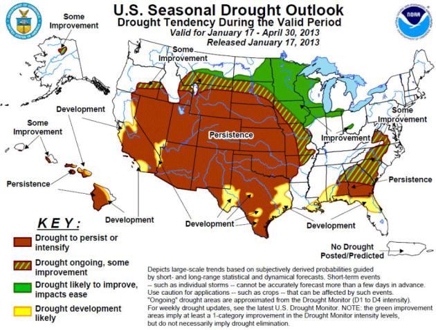
Drought Outlook Through Late April.
NOAA CPC
is still indicating "some improvement" for the drought gripping
Minnesota, western Wisconsin and the northeastern half of Iowa, but
"persistence" for much of the Plains and Southwest, meaning no change.
In fact the drought is forecast to get worse from California and the Las
Vegas area into Texas and the Gulf Coast.
Tracking An Extra-Extreme January. Nearly 800
separate severe weather reports Tuesday and Wednesday, nationwide?
That's the most since late July, 2012, and it's odd seeing this kind of a
spike in extreme straight-line winds and tornadoes...in late January.
Check out the
2:30 YouTube clip: "
There
are hundreds of storm reports from the January 29th and 30th severe
outbreak. And those reports span across several states from the
Southeast to the Lower Ohio Valley and the Northeast. Meteorologist
Paul Douglas looks at how rare this January outbreak is and discusses
what could be in store during the months ahead."
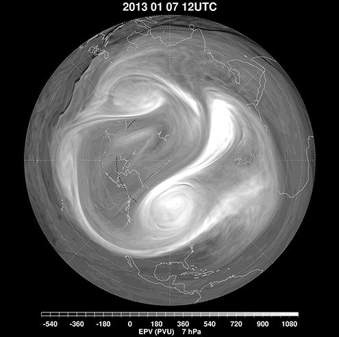
GOES-5 Tracks Major Sudden Stratospheric Warming Event Of January.
The polar vortex suddenly split up into 3 smaller vortices in January,
preceded by a sudden upward spike in stratospheric temperatures in the
upper atmosphere. Details via
NASA: "
Stratospheric
sudden warmings (SSWs) are a ubiquitous feature of the wintertime flow
in the northern hemisphere. Discovered more than sixty years ago
(Sherhag, 1952) when radiosonde observations began to provide routine
observations at altitudes higher than 20km above the surface of the
earth, these events take their name from a rapid temperature increase
of several tens of Kelvin over a few days in the high northern
latitudes. Since the initial discovery of this warming, routine
radiosonde observations and satellite datasets have been used to
construct a fairly complete picture of the dynamical nature of these
events, which are caused by the propagation and evolution of planetary
scale wave motions in the troposphere and stratosphere. A major
midwinter SSW event occurs when polar stratospheric temperatures
increase by at least 25 K in one week, and the zonal-mean zonal wind at
or near 10 hPa (at about 30km altitude) reverses direction and becomes
easterly north of 60° N. Research has led to a good documentation of
the frequency and seasonality of sudden warmings: just over half of the
winters since 1960 have experienced a major warming event in January or
February (e.g., Charlton and Polvani, 2007). The event in early
January 2013 is thus not atypical, but, like all of these events, has
unique dynamical characteristics in terms of its development and
interactions with the tropospheric flow..."
Image credit above: "
January 7, 2013, showing the breakdown of the polar vortex into three smaller vortices." NASA.
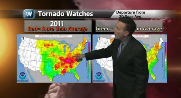
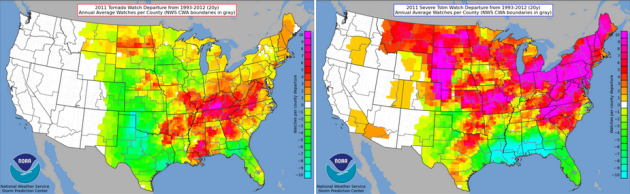
2011: North/East Shift Of Severe Watches Issued.
2011 may have been the most extreme year, weatherwise, in U.S. history.
One interesting nugget from NOAA shows the departure from the 20-year
normal in Tornado Watches (upper left) and Severe Storm Watches (upper
right). Tornado Alley shifted toward "Dixie Alley", over the Ohio Valley
and Mid South, while far more (than average) Severe Storm Watches were
issued for northern states, from the Dakotas to New England. Source:
NOAA.
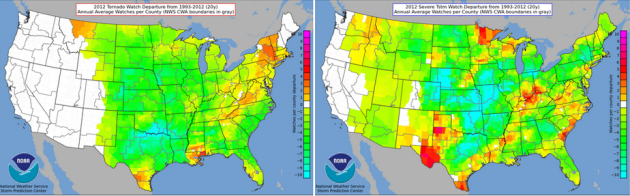
2012: What A Difference A Drought Makes. With last
year's record heat, and the worst drought for the Plains since the
1950s, there was no upward spike in Tornado Watch Issuance from SPC
(upper left), in fact it was one of the quietest years on record for
traditional Tornado Alley. More Severe Storm Watches than average were
observed over the Minnesota Arrowhead and parts of the Ohio Valley.
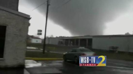
Tornado Forms In Front Of WSB's Ross Cavitt. The tornado that hit Adairsville (northwest Georgia) Wednesday morning was a strong EF-3; winds over 110 mph.
TVSpy has more details on how this (remarkable) footage was captured - right place - right time: "
At
least one person is dead after a tornado touched down in Adairsville,
Ga., Wednesday afternoon. Footage of the tornado was captured by WSB reporter Ross Cavitt,
who had just arrived on the scene and was reporting from about a
quarter mile away (video above). All four Atlanta stations — ABC
affiliate WSB, CBS affiliate WGCL, NBC affiliate WXIA and Fox O&O WAGA
— have been in continuing coverage of the severe weather for several
hours. The area remains under a severe thunderstorm warning. [via CNN]"
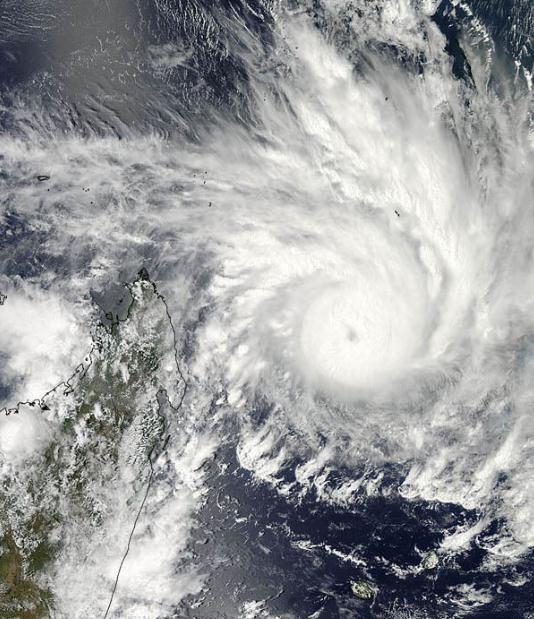
Cyclone's "Overshooting Tops" Seen From Above. Here's a snippet of an interesting
Yahoo News story focused on Cyclone Felling - off the coast of Madagascar: "
Tropical Cyclone Felleng, currently spiraling off the east coast of the island of Madagascar, was caught in a NASA
satellite image exhibiting "overshooting cloud tops," a clear sign that
it is packing powerful storms. A NASA statement describes an
overshooting cloud top as a domelike protrusion that balloons out from
the anvil head of thunderstorm cloud and shoots up into the
stratosphere, the layer of the atmosphere above the troposphere. The troposphere is where most weather on Earth occurs. The overshooting top
is indicative of powerful storms because it takes a lot of energy to
push through the tropopause, the boundary between the troposphere and
stratosphere and where the temperature of the atmosphere goes from decreasing with height to increasing with height..." (Satellite photo: NASA Goddard MODIS).
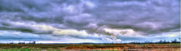
A Wintry Sky. Thanks to
Mike Hall Photography for a glimpse of what the sky over Lewisport, Kentucky looked like after Wednesday's squall line swept thru.
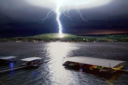
"Call Down The Sky". I have no information about who snapped this (perilously close) photo of C to G lightning. The original is at
cheezburger.com.
Blackberry Z10 vs. Apple iPhone 5. I like my "5",
but I'm trying to keep an open mind. How does the new smartphone from
Blackberry (you remember them, right?) stack up? Here's an excerpt of a
review from
gizmag.com: "
Pre-2007,
“BlackBerry” was practically synonymous with “smartphone.” Then the
iPhone came along ... then Android came along ... and eventually
“Blackberry” became synonymous with an inability to adapt. Now, in
2013, the company is finally doing something new. Does its first
serious multitouch handset, the BlackBerry Z10, have what it takes to take on the iPhone 5? Let’s see how their specs – and harder-to-define intangibles – compare...."
* gizmag.com has more information on a new
128 GB iPad,
set to be released next Tuesday, February 5. Ah yes, as I gaze out over
all my (suddenly obsolete) gadgets and productivity devices.
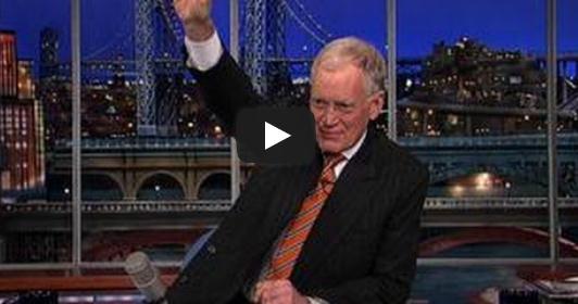
"Letterman's Top 10 Changes Coming To CNN". TVNewser has the very funny video clip. Here are Dave's suggestions (some of these could work):
10. The Situation Room now hosted by The Situation
9. Sanjay Gupta’s hilarious new sitcom: “Two Broke Guptas”
8. Changing pronunciation from C-N-N to “CNNNN”
7. Switching the part in David Gergen’s combover
6. Wolf Blitzer – shirtless
5. No longer fact-checking stories
4. New president, Jeff Zucker – Zucking everything up
3. Lifting ban on anchors using steroids
2. Piers Morgan: deported
1. More coverage of goats (video of goat attacking reporter)
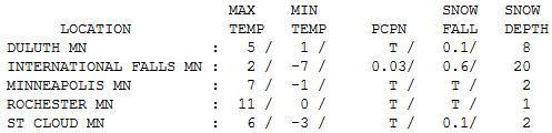
Arctic Fun! I prefer to think of this as
severe-cool. Highs never rose above zero at Redwood Falls yesterday,
highs ranging from 0 at Alexandria to 6 St. Cloud, 7 in the Twin Cities
and 11 at Rochester. Officially St. Cloud and MSP have 2" of snow on the
ground, a hefty 20" reported at International Falls.
Note To Self: Remember To Close Windows And Sunroof. Thanks to
jokeroo.com for passing this one along. Priceless.
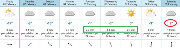
Paul's Conservation Minnesota Outlook for the Twin Cities and all of Minnesota:
FRIDAY: A bad Yukon Vacation! Feels like -25. At least the sun's out. Winds: SW 10. High: 6 (by late evening)
FRIDAY NIGHT: Clouds increase, not quite as cold. Low: 4
SATURDAY: Less numb. Coating to 1/2" of snow late? High: 19
SUNDAY: Chilled sun much of the day. Wake-up: 12. High: 17
MONDAY: Patchy clouds, few flakes in the air. Wake-up: 10. High: 18
TUESDAY: Next clipper. Light snow possible. Coating to an inch (more north). Wake-up: 13. High: near 30
WEDNESDAY: Breezy, almost "average". Wake-up: 15. High: 24
THURSDAY: Snow tapers early, a brief thaw? Wake-up: 14. High: 32
Climate Stories...
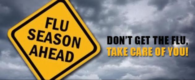
Global Warming Linked To Worse Flu Seasons. Here's an excerpt of a story at
UPI: "
Climate
change will add earlier and more severe flu seasons, U.S. researchers
say. Study leader Sherry Towers, a research professor at Arizona State
University, studied waves of influenza and climate patterns in the
United States from the 1997-98 season to the present. The research team
said data from the Centers for Disease Control and Prevention indicate a
pattern for both A and B strains: Warm winters were usually followed
by heavy flu seasons. "It appears that fewer people contract influenza
during warm winters, and this causes a major portion of the population
to remain vulnerable into the next season, causing an early and strong
emergence," Towers said in a statement..."
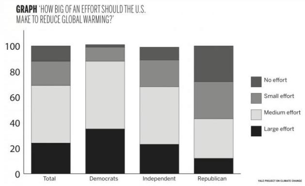
Yale Report Shows Nation Favors Action On Climate Change. Here's the intro to a story at
The Yale Daily News: "
Americans
are paying more attention to climate change, according to a Yale report
released earlier this month. The majority of Americans want the United
States government to take action against climate change and will
consider candidates’ stances on the issue when casting their vote,
according to a Jan. 15 report by the Yale Project on Climate Change
Communication. This YPCCC report, called “The Political Benefits to
Taking a Pro-Climate Stance in 2013,” shows that 88 percent of
Americans overall — including 72 percent of Republicans — believe that
the United States should make at least a small-scale effort to reduce
global warming. Reflecting a September 2012 survey, these
record-breaking numbers are part of a steady upward trend in public
support for action on climate change. But perhaps more importantly,
this study shows that the stance of independent voters toward global
warming is changing, said YPCCC Director Anthony Leiserowitz..."
Humans Have Already Set In Motion 69 Feet Of Sea Level Rise.
Hype? Alarmism? I sure hope so. But it might be short-sighted to
totally discount one the glaciologists focused on tracking ice loss in
Greenland and Antarctica, featured in this
Mother Jones article; here's an excerpt: "
Last week, a much discussed new paper
in the journal Nature seemed to suggest to some that we needn't worry
too much about the melting of Greenland, the mile-thick mass of ice at
the top of the globe. The research found that the Greenland ice sheet
seems to have survived a previous warm period in Earth's history—the Eemian period,
some 126,000 years ago—without vanishing (although it did melt
considerably). But Ohio State glaciologist Jason Box isn't buying it. At
Monday's Climate Desk Live briefing
in Washington, D.C., Box, who has visited Greenland 23 times to track
its changing climate, explained that we've already pushed atmospheric
carbon dioxide 40 percent beyond Eemian levels. What's more, levels of
atmospheric methane are a dramatic 240 percent higher—both with no signs
of stopping. "There is no analogue for that in the ice record," said
Box..."
Kerry Could Spearhead Bilateral Climate Change Agreements. Here's a snippet from an article at
MIT Technology Review: "...
The
nomination of John Kerry, who was confirmed as secretary of state this
week, is certainly in line with a push for climate change action.
Kerry has long spoken out about climate change, and he led the failed
effort to pass climate legislation in the Senate in 2010, after the
House had passed its own version. As secretary of state, it’s possible
that Kerry will spearhead international climate change agreements.
Efforts at worldwide agreements have failed, but some proponents of
climate change treaties are making the case that limited agreements,
such as one between the U.S. and China, two of the world’s largest
emitters of carbon dioxide, could have a big impact on emissions.
Speaking at an energy innovation conference in Washington DC this week,
Environmental Defense Fund president Fred Krupp said, “I’m not
optimistic that we’re going to have some Copenhagen-like multilateral
agreement. But I do think there’s a chance of some bilateral agreements
with John Kerry as secretary of state...”


thisaction will probably be ready todifferent this?I think not.Upon all, women's Dog leashes
ReplyDelete