-36 F. low at Embarrass, Minnesota Tuesday morning. More low temperatures here.
-12 F. low temperature Tuesday morning.
2 F. high temperature yesterday in the Twin Cities.
24 F. average high on January 22.
26 F. high on January 22, 2012.
Coating of snow possible late Thursday, maybe an inch or two Sunday morning. No major storms are brewing.
Low 30s expected early next week. Grilling weather.
Embrace the Numb
Perhaps it's rationalization. Maybe my on-air
team at WeatherNation TV had a collective case of brain-freeze?
Yesterday they came up with a head-scratching list of "Cold Weather
Advantages"; why we should all embrace the numb.
No bugs. No humidity (no kidding - my closet is
crackling with static charge). Ice cream won't melt coming home from the
grocery store. You burn more calories to keep warm; getting you closer
to your New Year's Resolution! Schools sometimes close - as they did in
Duluth. More sun dogs and sun pillars. And you hear from old (gloating)
friends down in Scottsdale and Ft. Myers.
You'll have a chance to return the favor when Phoenix melts into the desert and Hurricane Bubba approaches Naples.
Patience.
Where else on the planet does 0 F qualify as a
warm front? Moscow? Oslo? Low 30s will feel good early next week.
Sunday's warm front sparks an inch or two; next week's big storm passes
south/east of Minnesota. Again. The old Doppler is collecting dust.
I'm worried: lake water levels are down,
aquifers running low, precious little water in our topsoil or the thin
gruel of snow cover. The pattern better shift soon - otherwise drought
will be the big story of 2013.
* graphic above courtesy of WeatherNation TV.
Coldest Daytime High In Duluth In Nearly 6 Years. No wonder many schools canceled classes yesterday; details from the
Duluth office of the National Weather Service: "...
High
temperatures Monday afternoon, January 21st, ranged from the negative
teens to around 20 degrees below zero across northeast Minnesota, to the
negative single digits over northern Wisconsin. These high temperatures
are the coldest daytime highs most areas have experienced in several
years. As of 4 pm (January 21st), the Duluth airport has reached a high
temperature of just negative 10 degrees F. The last time Duluth saw a
high temperature this cold was in February 2007. International Falls, MN
however has topped out today at negative 12 degrees F.; last seen as
recent as January 2009. The high temperature of negative 7 degrees F at
Brainerd, Minnesota was also last seen in January 2009."
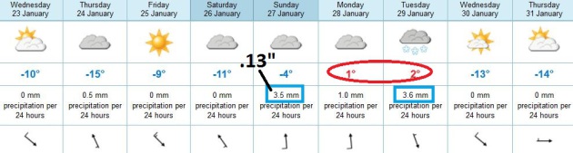
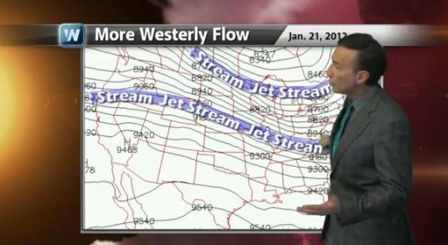
A Dim Light At The End Of Our Cold Tunnel. Welcome
to the coldest week of winter. I think I may have mentioned that a
couple weeks ago. I'm sorry I was right. Temperatures creep toward 10 F.
(above!) today, the next weak clipper capable of a Thursday dusting.
After a cold start Saturday temperatures begin to finally rebound as the
flow becomes more westerly, from the Pacific. The arrival of warmer air
may set off an inch or two of snow Sunday, then low 30s return Monday
and Tuesday. Hallelujah. An inch or so of slush is possible Tuesday from
a storm spinning up to our east; we just get a glancing blow of sloppy
snow before colder air arrives by the middle of next week. ECMWF highs
above in Celsius. No, it won't be THAT cold.
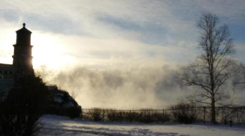 The Source Of "Lake Effect".
I love this photo from Split Rock Lighthouse north of Duluth, along the
rocky shoreline of Lake Superior. You can see the air churning above
the relatively warm lake water as bitter air pours over the lake. This
will result in some 1-2 foot snowfall amounts on the downwind side of
Superior. Details via
FB: "
Lake Superior is a steaming cauldron this morning. Open water and -17. This is where lake-effect snow comes from."
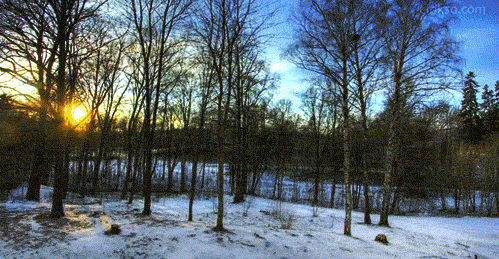
Fast Forward Seasons. Lately (last 15 years or so)
it seems like Mother Nature has picked up her Jumbo Weather DVR, put our
seasons on fast-forward, and turned the volume of extreme weather up to
a "10". The amazing animated gif above, showing the progression of
seasons, is courtesy of Eirik Solheim at
eirikso.com.
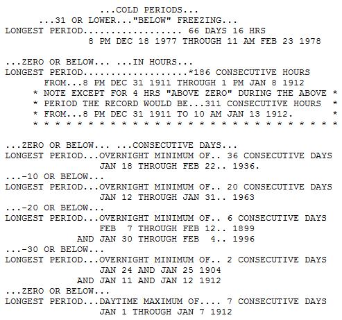
Cold Weather Perspective. Yes, it's cold out there,
but this Arctic front pales in comparison with what we endured in 1996,
1976-78 and 1911-12. Those were real winters. Information above courtesy
of the
Minnesota Climate Office.
Atmospheric Payback. After an unusually mild
December across most of the USA, Old Man Winter is (finally) making up
for lost time, with subzero weather skirting the northern tier states.
Why was last January so balmy, in comparison with this winter? How is a
lack of snow over northern states impacting the severity of the cold.
Here's the latest installment of "Climate Matters", courtesy of
WeatherNation TV and
YouTube: "
Are
you feeling the bitter cold yet? Folks in the Midwest already watched
their temps nosedive. Folks in the eastern states next. Meteorologist
Paul Douglas looks at the winter so far and how it compares to
previous years. What do you think?"
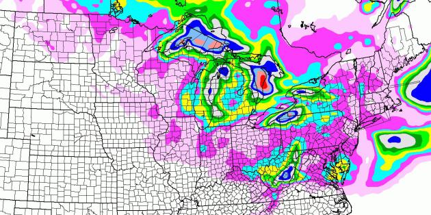
Mostly Lake Effect. The NAM model (above) shows
expected snowfall between now and midnight Friday. The big story: lake
effect snows, as much as a foot downwind of Lake Superior and Lake Erie.
A couple inches may fall over the Delmarva Peninsula and the hills of
West Virginia; the risk of significant snow for Boston has diminished
slightly.
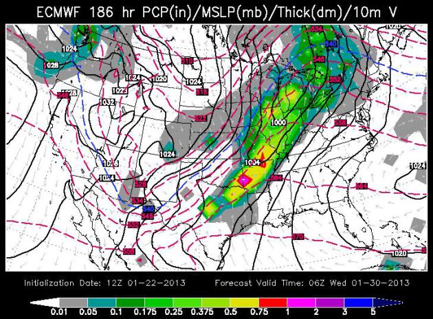
Low Expectations The models giveth, and they taketh
away. As I suspected yesterday, next week's storm will track too far
south/east of Minnesota for significant snow here; maybe an inch or so
of slushy snow late Tuesday before winds turn to the northwest. The
atmosphere may be warm enough aloft for mostly-rain across the Midwest
and Great Lakes. ECMWF model forecast for Tuesday night around midnight
courtesy of WSI.
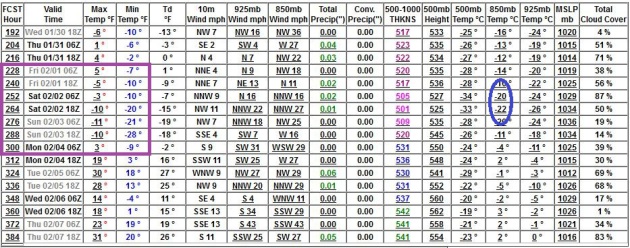
Cold Start To February - Not Quite As Nanook As This Week.
Long range (GFS) guidance shows a numbing couple of days as we limp
into February, maybe 2-3 nights below zero - although I suspect it won't
be as cold as it was Monday and Tuesday. Some moderation is likely by
the second week of February.
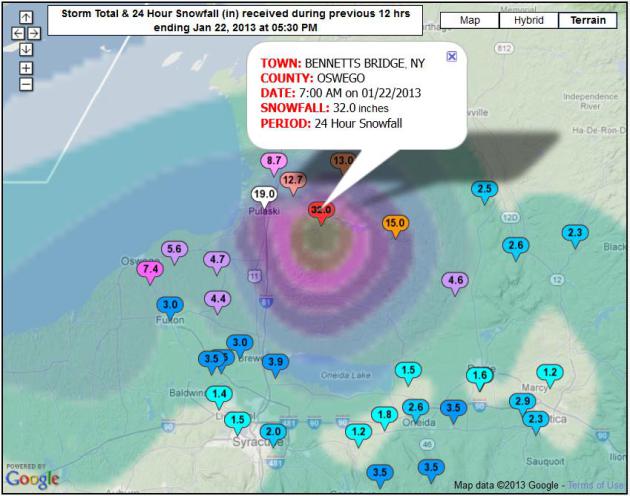
Serious Lake Effect Snow. 32" of snow in 24 hours at
Bennetts Bridge, New York, close to the Lake Effect Capital of the
Northeast, Oswego, New York? Pretty impressive. For an interactive
NOAA map with the latest snow totals
click here.
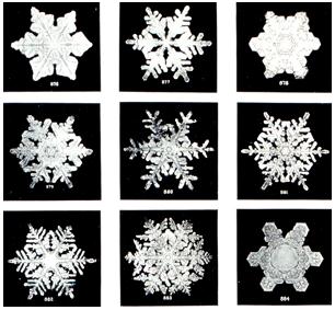 How Do Snowflakes Form?
 Here's an excerpt of the answer from
NOAA:
"...
These ice crystals that make up snowflakes are symmetrical (or
patterned) because they reflect the internal order of the crystal’s
water molecules as they arrange themselves in predetermined spaces
(known as “crystallization”) to form a six-sided snowflake. Ultimately, it is the temperature at which a crystal forms —
and to a lesser extent the humidity of the air — that determines the
basic shape of the ice crystal. Thus, we see long needle-like crystals
at 23 degrees F and very flat plate-like crystals at 5 degrees F. The intricate shape of a single arm of the snowflake is
determined by the atmospheric conditions experienced by entire ice
crystal as it falls. A crystal might begin to grow arms in one manner,
and then minutes or even seconds later, slight changes in the
surrounding temperature or humidity causes the crystal to grow in
another way. Although the six-sided shape is always maintained, the ice
crystal (and its six arms) may branch off in new directions. Because
each arm experiences the same atmospheric conditions, the arms look
identical...."
"Ask Paul". Weather-related Q&A:
"
I happened to run across a NASA web site that described three
different variations in the Earth's orbit around the sun. As I recall,
they occur every 19,000, 45,000, and 100,000 years.
Question: Is it possible that we are in one or more of these
orbit shifts, and is it possible that this is part of the climate change
picture? I haven't heard anyone discuss these shifts, and the
possibility of an impact.
Keep up the good work."
Art Warner
Little Falls, MN
Art - thanks for a thoughtful question. In millenia gone by Earth's
climate has shifted for a variety of reasons, changes in orbit, the
Earth's tilt on its axis, swarms of volcanic eruptions, possibly even
variations in solar output. Throughout history greenhouse gas levels
have varied from 180 to 280 ppm (parts per million in the atmosphere).
Now we're at 394 ppm, a 40% spike in greenhouse gases due to burning of
fossil fuels, most of that in the last 50 years. My friend and
colleague, climate scientist Dr. John Abraham from St. Thomas provided
me with some perspective. "
We are always in one of those shifts.
Problem is they change the climate over 10,000 year periods. We are
changing climate over 100 year periods."
Hi Paul,
Has there ever been a "snownado" (a tornado recorded during a snowstorm?)
Thanks..
Brent Metfessel
Eden Prairie
Brent - I've never heard of such a thing, 'nor do I think it's even
theoretically possible. Tornadoes require violent updrafts, as well as
shifting wind direction/speed with altitude (wind shear). During the
winter, with snow on the ground you just don't have the instability that
exists in spring and early summer. I've heard reports of tornadoes
passing over the Rockies, tracking over patches of snow, but not an
actual "snownado".
Sour In The Sun? 3 Unexpected Ways Weather Affects Your Moods.
Every day I'm reminded of the depths of my ignorance (by my wife, and a
steady stream of fascinating articles). Here's another one that caught
my eye, from
Psychology Today: "...
In
a study conducted in the 1980’s, researchers found that out of eight
weather variables (hours of sunshine, precipitation, temperature, wind
direction, humidity, change in barometric pressure, and absolute
barometric pressure), humidity was the best predictor of mood outcomes.
On days when humidity was high, participants reported being less able
to concentrate and feeling sleepier. Other researchers have also found a
link between high humidity and increased tiredness using controlled
experimental methods. In contrast, participants reported increased
pleasantness when in low humidity conditions..."
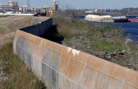
Deficient Levees Found Across America. KAALTV.com has the story; here's an excerpt: "
Inspectors
taking the first-ever inventory of flood control systems overseen by
the federal government have found hundreds of structures at risk of
failing and endangering people and property in 37 states. Levees deemed
in unacceptable condition span the breadth of America. They are in
every region, in cities and towns big and small: Washington, D.C., and
Sacramento Calif., Cleveland and Dallas, Augusta, Ga., and Brookport,
Ill. The U.S. Army Corps of Engineers has yet to issue ratings for a
little more than 40 percent of the 2,487 structures, which protect
about 10 million people. Of those it has rated, however, 326 levees
covering more than 2,000 miles were found in urgent need of repair..."
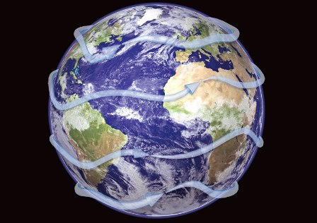
Global "Superjet" Winds Could Explain Record Rains And Tornadoes. Here's an article that caught my eye from
beforeitsnews.com: "
Two
talks at a scientific conference in December 2012 proposed a common
root for an enormous deluge in western Tennessee in May 2010, and a
historic outbreak of tornadoes centered on Alabama in April 2011. Both
events seem to be linked to a relatively rare coupling between the polar
and the subtropical jet streams, says Jonathan Martin,
a University of Wisconsin-Madison professor of atmospheric and oceanic
sciences. But the fascinating part is that the change originates in the
western Pacific, about 9,000 miles away from the intense storms in the
U.S. midsection, Martin says...." (image above:
flying-geeks.com).
"Hurricane Hunters" Weather Storms To Save Lives. Here's an excerpt of a story from
The U.S. Department of Defense: "
As
the nation rebounds from 19 named storms and 11 major hurricanes in
2012, a small but hardy military organization keeps relentless watch to
track and prepare for such disasters. Located at Keesler Air Force
Base, Miss., the 53rd Weather Reconnaissance Squadron, dubbed the
“Hurricane Hunters” of the Air Force Reserve, is the Defense
Department’s sole organization dedicated to flying into tropical storms
and hurricanes. The unit has performed the mission since 1944. In a
“DOD Live” bloggers roundtable today, Lt. Col. Jon Talbot, 53rd WRS
chief meteorologist, and Capt. John Brady, a meteorologist with the
squadron, said collecting winter storm, hurricane and tropical cyclone
data for the National Weather Service is critical in mitigating loss of
life and property..."
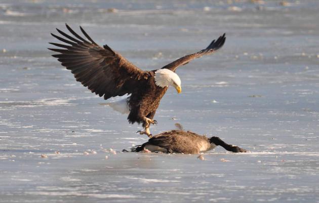
The Eagle Has Landed. Bernie Engels writes: "thought
you might like to see how the cold snap has affected our local
population of eagles near Rochester. They have a new item on the menu,
and it doesn't have scales!"
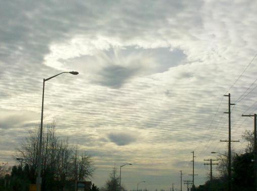 "Hole Punch Cloud"
. This is an unusual formation, captured by
Don Clark
in Auburn, Washington. Turbulence around a descending jet provided
enough additional "lift" for snow to fall out of a layer of mid-level
clouds, leaving a clear hole behind:
"
I heard like a plane or planes go by then three sounds like thunder or
concusions, then I saw these strange clouds appear. I watched this
unfold shortly after the fog lifted."
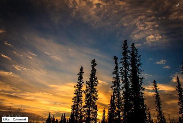
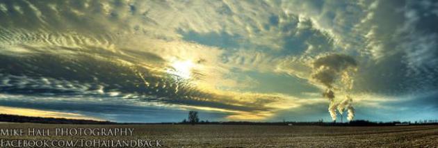 Winter Panorama
. Uber-photographer Mike Hall snapped this
photo
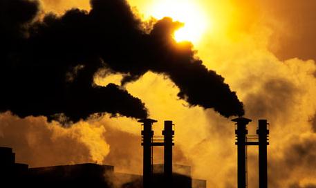
of the setting sun near Lewisport, Kentucky Tuesday evening - talk
about a chaotic sky. Note the massive plumes from power plants in screen
right, much more pronounced as bitter air envelopes the Ohio Valley.
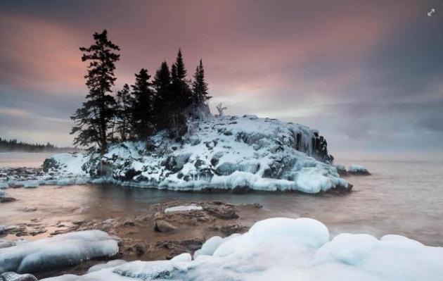
"Cold Enough Out There For You?" I love this photo, courtesy of Bryan Hansel Photography, via
Facebook and WeatherNation TV, who writes: "
When
I left my house this morning, it was -24F. On the Lake Superior shore
at my favorite tombolo/island, it was -17F. With the wind chill it was
about -32F. The temp is dropping, too. It's now -27F with a wind chill
of -54F. I've never really understood the wind chill thing as the
temperature doesn't actually get colder, but I guess they use it because
it just feels colder. I guess it's
sort of like waves, when the wind blows the waves get higher. Maybe we
should make wind chill into a scale like the Beaufort sea scale. When
it's -54F wind chill, we could call it a Winter Force 7.
Anyway, enough winter musing. This morning, I ventured to my favorite
tombolo. It's east of Grand Marais by about 10 miles. To get to the
point where I set up my tripod, I had to wade across a gap (water was
flowing through it like a stream), slip across ice and then balance on
an uneven surface of glare ice. I waited for twenty minutes tucked into
my hood, while my glasses froze and my breath coated my collar with
rime. Then the pink happened."
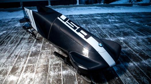
A Bimmer Bobsled? Who wouldn't want this baby in their garage?
Gizmag.com has details on a BMW you can't buy: "
Last November, BMW DesignworksUSA announced that it was in the process of designing a new state-of-the-art two-man bobsled
for the US Bobsled Team. At the time, only a vague teaser sketch of
the sled was available. Now that one of the prototypes has been raced,
however, we get to see some actual photos – and the thing looks pretty
sharp. Its performance is also promising..."
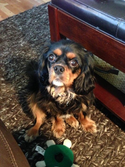
"Leo, Do You Want To Go Out And Do Your Business?"
This is the look I got from my dog after asking that (stupid) question. I
could just hear him thinking "what do you think? NO!" I'm trying to
teach him to use the commode, but so far not much luck. What a YouTube
video that would make...
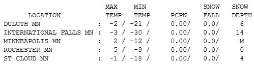
Struggling Toward Zero. Only in Minnesota could 0 F
be misconstrued as a "warm front". Much of northern and western
MInnesota still experienced subzero highs yesterday; -1 F. at St. Cloud,
a high of 2 in the Twin Cities, 5 at Rochester and 6 at Redwood Falls.
Lovely.
Paul's Conservation Minnesota Outlook for the Twin Cities and all of Minnesota:
TODAY: Partly sunny, mostly numb. Winds: NW 10-15. High: 12
WEDNESDAY NIGHT: Partly cloudy, still plenty cold. Low: -6
THURSDAY: Clouds increase, late flakes. High: 14
FRIDAY: Sunny peeks, annoying breeze. Wake-up: 5. High: 15
SATURDAY: Cold start. Fading sun, better travel day. Wake-up: -5. High: 17
SUNDAY: Morning snow (inch or two?), turning milder by afternoon. Wake-up: 15. High: 29
MONDAY: Mostly cloudy. Risk of a thaw. Wake-up: 19. High: 33
TUESDAY: Wet snow possible. No big deal. Wake-up: 23. High: 34
* photo above courtesy of
Birch Leaf Photography.
Climate Stories....
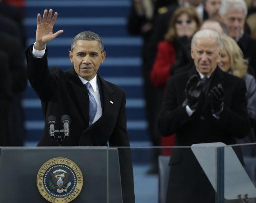
“
We will respond to the threat of climate change, knowing that
failure to do so would betray our children and future generations,” Mr.
Obama said on Monday at the start of eight sentences on the subject,
more than he devoted to any other specific area. “Some may still deny
the overwhelming judgment of science, but none can avoid the
devastating impact of raging fires, and crippling drought, and more
powerful storms.” - from President Obama's Inaugural Address, courtesy of the
New York Times.
Speech Gives Climate Goals Center Stage. President Obama devoted more of his Inaugural Address to climate change than any other topic; here's a summary from
The New York Times: "
President Obama made addressing climate change the most prominent policy vow of his second Inaugural Address,
setting in motion what Democrats say will be a deliberately paced but
aggressive campaign built around the use of his executive powers to
sidestep Congressional opposition...The central place he gave to the
subject seemed to answer the question of whether he considered it a
realistic second-term priority. He devoted scant attention to it in the
campaign and has delivered a mixed message about its importance since
the election...."
Photo credit above: "
President Barack Obama waves after
his speech while Vice President Joe Biden applauds at the ceremonial
swearing-in at the U.S. Capitol during the 57th Presidential
Inauguration in Washington, Monday, Jan. 21, 2013." (AP Photo/Pablo Martinez Monsivais)
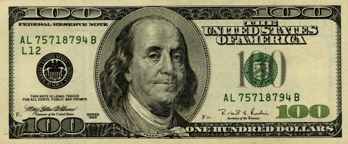
Ben Franklin, Climate Science, And National Security. Here's an interesting angle, an excerpt from an eye-opening
Huffington Post article. I did not know that: "...According to British naturalist Gilbert White, "
the
sun, at noon, looked as blank as a clouded moon." When rising and
setting, it was "particularly lurid and blood-coloured." The heat was
so intense that meat went bad the day after it was butchered, and
swarms of flies made life miserable. The seeds of climate science in
America were very possibly being planted as Franklin observed the
changes 200+ years ago. Conditions went from bad to worse as Europe and
North America were plunged into a deep freeze that winter. In its
first peacetime year as an independent nation, the United States had to
contend with more extreme weather than the colonies had ever
experienced. New England suffered a record below-zero weather streak.
The Mississippi River froze as far south as New Orleans. Ice appeared
in the Gulf of Mexico..."
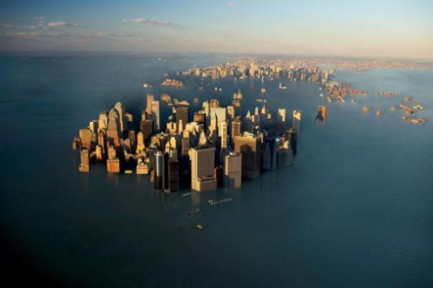
How High Could The Tide Go? Here's an excerpt of an important story from Justin Gillis at
The New York Times: "...
For the leader of the team, Maureen E. Raymo
of Columbia University, the find was an important clue as she tries to
determine just how high the oceans might rise in a warmer world. The
question has taken on new urgency in the aftermath of Hurricane Sandy,
which caused coastal flooding that scientists say was almost certainly
worsened by the modest rise of sea level over the past century. That
kind of storm tide, the experts say, could become routine along American
coastlines by late in this century if the ocean rises as fast as they expect. In previous research,
scientists have determined that when the earth warms by only a couple
of degrees Fahrenheit, enough polar ice melts, over time, to raise the global sea level by about 25 to 30 feet...."
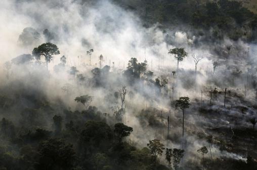
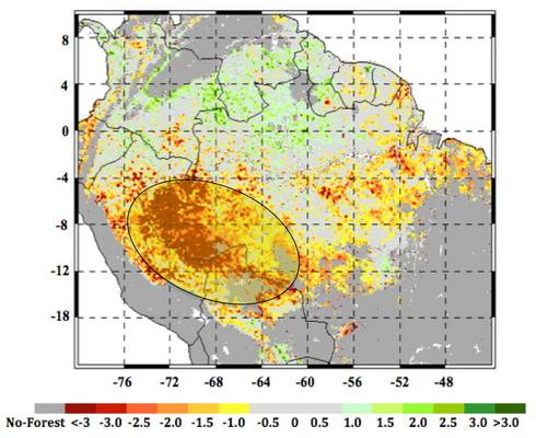
Amazon Rainforest Under Threat From Climate Change. Here's a snippet of a story at
redorbit.com: "...
An
international team of scientists analyzed more than a decade of
satellite microwave radar data collected beginning in 2000 over the
Amazon rainforest. The observations, which included measurements of
rainfall from NASA’s Tropical Rainfall Measuring Mission (TRMM)
and measurements of the moisture content and structure of the forest
canopy (top layer) from the Seawinds scatterometer on NASA’s QuikScat
spacecraft, showed that during the summer of 2005, more than 270,000
square miles of pristine, old-growth forest in southwestern Amazonia
underwent an extensive, severe drought. Satellite images were able to
detect the widespread changes to the forest canopy caused by this
megadrought, including dieback of branches and tree falls. This is
especially true among the older, larger, more vulnerable canopy trees
that blanket the forest...."
File Photo credit above: "
Rainforest being cleared by
farmers, south of Itaituba, Para State, Brazil. Part of "Full
Exposure: Images to Change the Future," a photography symposium
featuring acclaimed photographers Daniel Beltra and Molly Steinwald on
June 11 at the Arboretum."
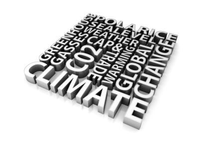
Public Acceptance Of Climate Change Affected By Word Usage.
Do the words climate scientists use impact acceptance levels (of the
science) on the part of the public? Here's an excerpt of a story from
Science Daily: "
Public
acceptance of climate change's reality may have been influenced by the
rate at which words moved from scientific journals into the
mainstream, according to anthropologist Michael O'Brien, dean of the
College of Arts and Science at the University of Missouri. A recent
study of word usage in popular literature by O'Brien and his colleagues
documented how the usage of certain words related to climate change has
risen and fallen over the past two centuries. Understanding how word
usage affects public acceptance of science could lead to better science
communication and a more informed public...." (image above:
sourcewatch.org).
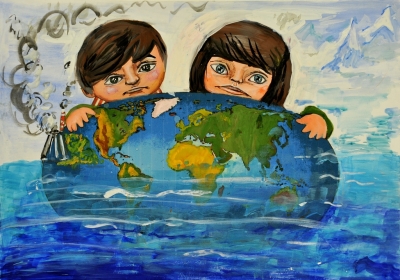
The No Spin Zone On Climate Change. Here's another
Huffington Post
story that caught my eye. In many respects, our kids seem to be wiser,
at least on matters of the environment and sustainability, than their
parents: "
Being a parent means you get to talk to kids to about
climate change. Not your own kids, of course. With them, you're lucky
if you can deduce what homework they have each night. But when their
friends come over after school, that's when you get a chance. And,
encouragingly enough, I've found a no-spin zone in talking with kids
about climate change -- something I rarely encounter when talking with
neighbors and colleagues steeped in op-ed page rhetoric. And it's in
these no-spin conversations that one of the important truths about
climate change comes out: global warming isn't a science problem. It's a
political problem. There is no mystery about how global warming works
or how dangerous it is. Even kids grasp the basics. The carbon
pollution from burning fossil fuels is heating up the atmosphere and
driving increasingly costly climate disruption..."
(Image credit
here).
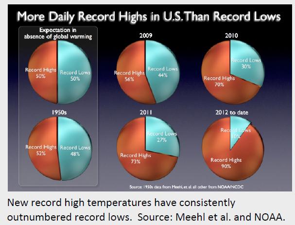
Warming Trend. If the atmosphere over the USA wasn't
warming you'd expect the number of record highs and record lows to be
comparable. Not so. You can see the progression of record highs vs. lows
since 2009, compared to the decade of the 1950s (lower left). Graphic:
Climate Nexus.
More Global Weather Extremes.
Huffington Post has an eye-opening account of some of the recent extremes around the planet; here's an excerpt: "
Newest Extreme Weather Casualty: Jakarta, Indonesia, a megacity of 10 million, is underwater, paralyzed, reports
Sarah Schonhardt at the Christian Science Monitor, from extreme
downpours, causing extreme flooding, and threatening investment... move
over, Manila... Amazon Drying Out, Likely From Climate Change, a new NASA study indicates, reports
Bailey Johnson at CBS News online. A megadrought that began in 2005
has persisted, and the area is showing widespread signs of not
recovering quickly enough to withstand the new frequency of droughts
occurring...."
Map credit above: "
A satellite image of the 2005 drought, now megadrought, in the Amazon, with the worst imacts in red and yellow." (Credit: NASA/JPL-CALTECH/GFSC)
Averting Climate Change May Cost $700 Billion A Year. Here's an excerpt from a story at
Bloomberg: "
About
$700 billion a year of new spending on renewable power, low-carbon
transport and energy efficiency is needed to meet the United Nations
goal to cap temperature rises, a report for the World Economic Forum
showed. That cash is needed in addition to the $5 trillion a year
countries must spend on infrastructure for agriculture, transport, power
and water through 2020, according to a report released today by the
consultant Accenture Plc (ACN)
for the forum’s Green Growth Action Alliance. “This development needs
to be greened by re-evaluating investment priorities,” former Mexican
President Felipe Calderon,
chairman of the alliance, wrote in a forward to the report. “There
remains a considerable shortfall in investment. Closing this gap is our
collective task and one that we cannot afford to fail...”
NASA's Goddard Institute Says Global Warming Has Become Reality. Here's an except from
The Guardian Express: "
NASA
scientists are reporting new global warming data indicating that 2012
was the ninth hottest year since 1880, continuing a long-term trend of
rising global temperatures. Since the year 2000, the nine warmest years
on record have all occurred, with 2010 and 2005 ranking as the hottest
years in the 132-years since records have been kept. The Goddard
Institute for Space Studies monitors global surface temperatures on an
ongoing basis compared temperatures around the World in 2012 to the
average global temperature from the mid-20th century, analyzing data
that shows that the Earth continues to experience warmer temperatures
than several decades ago. The average temperature in 2012 was about 58.3
degrees Fahrenheit, which is 1.0 F hotter than the mid-20th century
baseline. The average global temperature has risen about 1.4 F since
1880..."


This article explains the role of wholesale optical labs in ophthalmology and optometry.
ReplyDeleteWholesale optical labs are usually needed by optometrists and ophthalmologists.
For more: scatterometry
A scatterometer or diffusionmeter is a scientific instrument to measure the return of a beam of light or radar waves scattered by diffusion in a medium such as air.See more at-: scatterometry
ReplyDelete