32 F. high in Minneapolis-St. Paul yesterday.
28 F. average high for February 11.
21 F. high on February 11, 2012.
Trace of snow yesterday in the Twin Cities.
29.4" snowfall so far this winter.
14.9" snowfall last winter as of February 11, 2012.
6" snow on the ground at KMSP.
Tornadoes or Drought?
People are asking about 2013. "What's the long
range outlook Paul?" Um. Changeable. "Can you be a little more vague?"
Here's what I've noticed in recent years: either a rash of tornadoes
(like in 2010) OR a bias toward drought. It's usually one or the other.
Pick your poison.
NOAA predicts some improvement in Minnesota's
drought by late April, and I think/hope they're right. I see subtle
signs the pattern may be shifting. I guess, all other things being
equal, I'd rather point to rotating red blobs on Doppler. At least a
busy tornado season implies enough moisture for farmers and our lakes.
And a drought would impact everyone.
The storm that dumped 18" on Audubon, Minnesota
(2-4" of slush in the metro) is long gone. No commute-snarling storms
are brewing; just a Thursday coating out ahead of the next cold surge
for late week. Highs hold in the teens by Saturday, but no subzero lows
are on tap looking out 2 weeks, at least not in the immediate metro
area.
Hey, that's progress!
I'm a naive optimist, but I really do believe the coldest days of winter are behind us now.
Last year we saw 70s by mid-March. Don't hold your breath this year. A potentially good omen for our drought?
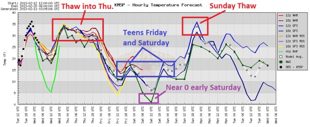
Two Cold Days - Nothing Arctic In Sight. Models show
highs near 30 today, possibly low to mid 30s Wednesday before cooling
off late in the week. Expect daytime highs in the teens by Friday and
Saturday, before thawing to near 32 F. by Monday. Graph: Iowa State.
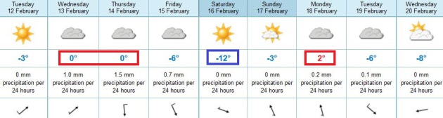
A Quiet Spell. Highs may top freezing (cue the
confetti) Wednesday and early Thursday before a brief temperature
tumble; Saturday looks like the coldest day in sight - highs stuck in
the teens (but the sun should be out). Temperatures recover by Sunday.
ECMWF forecast highs above in Celsius.
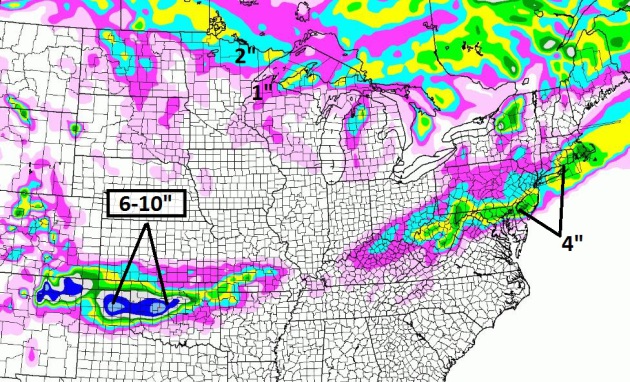
Ski Oklahoma. Looking for fresh powder this week?
Head to the Panhandle of Texas or northern Oklahoma, where some 6-10"
amounts are possible by Friday morning. A weak storm may drop 2-4"
slushy snow from Baltimore to Wilmington, Philadelpha and the Boston
area. Just what they need - more snow. NAM model guidance above courtesy
of Weathercaster.
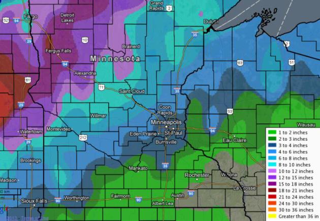
Snowfall Reports Sunday-Monday (courtesy of NOAA). Check out a high-res version of the map above
here.
...MINNESOTA...
BATTLE LAKE 2 S 17.0
PELICAN RAPIDS 6.3 NNW 14.5
CARLOS 3 SW 13.0
PELICAN RAPIDS 6 NNW 13.0
DONNELLY 3 W 12.0
GLENWOOD 12.0
KENT 12.0
DEER CREEK 2 WSW 11.7
BARNESVILLE 5 NE 11.5
FERGUS FALLS 11.0
LEADER 6 E 11.0
BENSON 1 SSE 10.5
SILVER BAY 10.5
GRANITE FALLS 10.0
MOTLEY 10.0
KABETOGAMA 2 SSW 9.6
SWANVILLE 1 SSW 9.5
GRAND RAPIDS 7 SE 9.0
LOWRY 9.0
CHISOLM 8.6
HIBBING 8.5
INTERNATIONAL FALLS 6.4
DULUTH 6.2
MINNEAPOLIS 2.2
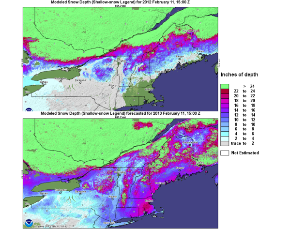
What A Difference A Year Makes. Check out the difference in snowcover from February 11, 2013 and February 11, 2012. Night and day. Details from
NOAA NOHRSC: "
A
comparison between the current snow depths across the northeast US
compared to the same time last year. Data is from the NWS National
Operational Hydrologic Remote Sensing Center (NOHRSC) in Chanhassen, MN."
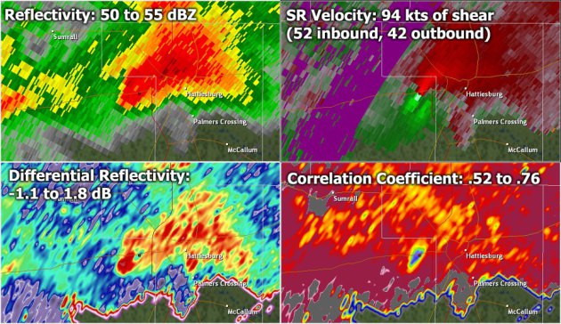
Dual Polarization Doppler Radar And The Hattiesburg EF-4 Tornado.
More details on how the new Doppler (which scans about the vertical as
well as the horizontal axis) from the Jackson, MS office of the
National Weather Service: "
As
the tornado moved into West Hattiesburg yesterday evening, we were
receiving multiple ground truth reports confirming the tornado. However,
thanks to recent dual-pol upgrades at area Doppler radar sites, we
could also confirm the presence of tornadic debris. Here is a screen
capture from the Mobile, AL radar at 5:13 pm as the tornado was moving
through the West Hattiesburg/Oak Grove area. The more traditional radar
products shown at the top (base reflectivity, storm relative velocity)
were showing a severe thunderstorm, with strong and tight rotation at
just over 7,000 feet above the ground. It was the dual-pol products on
the bottom of this image that provided additional confirmation that this
rotation must have been extending to the ground. The correlation
coefficient (CC) product in the bottom-right helps to provide an idea of
the consistency of the shape of the targets being reflected back to
the radar. Higher values shows greater consistency (for instance, all
rain), while lower values show less consistency (a mixture of targets).
In this image we see an area of lower CC, which is actually an
indication of tornadic debris of various shapes and sizes. In addition,
the differential reflectivity product indicated values close to 0,
which would also be expected with tornadic debris. Dual-pol continues
to prove to be a powerful tool in our arsenal of technology enabling us
to track severe weather."
* the Hattiesburg EF-4 (with winds estimated as high as 170 mph) was
on the ground for 20 miles, leaving behind a trail of damage, 82
injuries, but (miraculously) no fatalaties. The wedge tornado was
clearly visible, striking after 5 pm local time, moving east at close to
50 mph. Had it been a month or two earlier twilight would have made the
tornado difficult, even impossible to see, which could have resulted in
a significant death toll.
Details here.
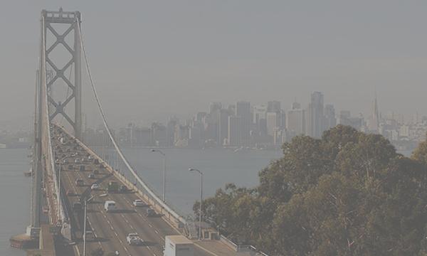
What Would Your City Look Like With Beijing's Air? A "Smog Simulator".
Be glad you're not stuck in Bejing, where the air has been unbreathable
in recent weeks - locals warned to stay indoors. That's what happens
when a country doesn't have the equivalent of the EPA. Growth comes
first - who cares about the environment and public health?
Marketplace reports: "
A cloud of pollution three times the size of California blanketed China
last month that was so dangerous residents were warned to stay indoors
and avoid outdoor activities. Many locals reported visibility so poor
that buildings down the street were obscured. Images of Beijing covered
with murky brown air were a startling reminder of how rising pollution
from factories and automobiles can spoil the air in that
industrializing nation...."
I'm Bill Gates. I have a lot of respect for
Microsoft founder Bill Gates, now co-chair of the Bill and Melinda Gates
Foundation. Yesterday he gave a spirited (virtual) interview on the
popular site
Reddit. Check out the questions and answers - some of the comments are priceless too.
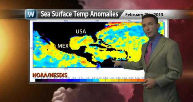
A Link Between Power Storms and Warm Sea Surface Temperatures? Here's the latest installment of "Climate Matters", a
2:30 YouTube clip prepared for WeatherNation TV: "
WeatherNation
Chief Meteorologist Paul Douglas examines the link between abnormally
warm sea-surface temperatures and powerful storms. Topics include the
recent southern tornadoes, the blizzard , and Superstorm Sandy."
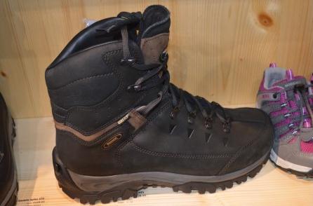
Winter Boots - With Spikes? My footwear helps me navigate glaze ice - and it's a weapon too! Details from
gizmag.com; here's an excerpt: "
German
footwear manufacturer Meindl recently added an innovative solution for
winter traction to its line. The metal spikes in the Tecvision Spike
System provide traction during the slipperiest winter conditions and
quickly retract back into the rubber sole when they're not needed. You
can tackle all winter conditions with one pair of boots..."
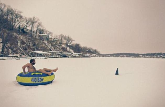
Uh Oh. This is a troubling photo, on so many counts. Where did he get a "Big Boy" float? Photo courtesy of
theCHIVE.
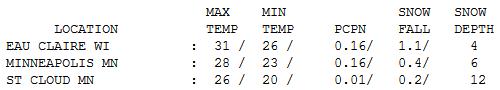
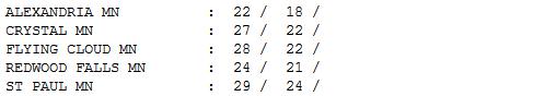
Cooling Down. Gusty winds behind Sunday's storm
reached 40 mph, whipping up blowing and drifting snow over parts of
central and western Minnesota. A fresh inch of snow fell at Eau Claire.
Highs ranged from 22 at Alexandria to 26 St. Cloud, 28 in the Twin
Cities and 31 at Eau Claire.
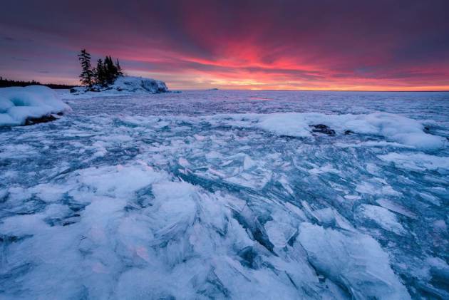
"Fire And Ice". Thanks to photographer Steve Burns, a gifted photographer (and MBA student at the University of Minnesota). He writes: "
I
did a photography workshop with Grand Marais photographer Bryan Hansel
this weekend. Here is my favorite shot of the trip which was from
sunrise on Saturday morning. Amazing display of fire and ice!"
Paul's Conservation Minnesota Outlook for the Twin Cities and all of Minnesota:
TODAY: Blue sky, a bit milder. Winds: SW 10-15. High: near 30
TUESDAY NIGHT: Partly cloudy, not as chilly. Low: 17
WEDNESDAY: Fading sun, a little light snow or flurries at night. High: 33
THURSDAY: Clouds and flurries, turning cooler. Wake-up: 24. High: 28
FRIDAY: Mostly cloudy, cold wind returns. Wake-up: 7. High: 19
SATURDAY: Bright sun, still chilly. Wake-up: 1. High: 14
SUNDAY: Partly sunny & breezy. Wake-up: 5. High: 26
MONDAY: Welcome thaw. Clouds increase. Wake-up: 18. High: 33
Climate Stories...
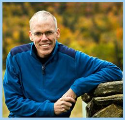
Celebrating and Preserving Winter. The American
Birkebeiner Ski Marathon is coming up; it's America's largest ski event
with 10,000 skiers, 5 separate races - it sold out back in October,
2012. As part of this event, author Bill McKibben, global climate
solutions leader at
350.org
(and avid cross country enthusiast) will be attending a a series of
presentations on climate change and the future of Minnesota's
(increasingly fickle) winters. I'll be making a presentation on severe weather trends, very much looking forward to introducing Bill at St. Thomas on February 20.
When: St. Thomas, February 20. Macalester College on
February 21, and in Hayward, WI on February 21. The theme: "What I Love
About Winter Weather".
Why: "To build an unstoppable movement toward climate stability and a smart, sustainable future for generations to come."
Details: at
www.coolplanetmn.org
Get Involved: organizers are looking for investors,
contributors, skiers and people interested in climate change to attend
SPEAK UP!! (a climate leadership training program on Sunday, March 10;
details to follow).
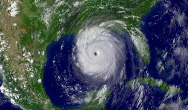
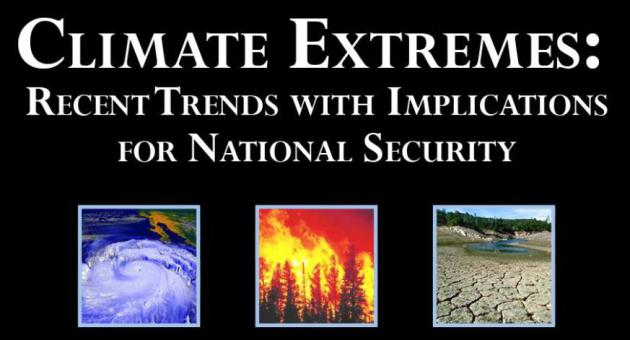
Security Risks of Climate Change And Extreme Weather. Here's an excerpt from
ScienceDaily: "
Increasingly
frequent extreme weather events such as droughts, floods, severe
storms, and heat waves have focused the attention of climate scientists
on the connections between greenhouse warming and extreme weather.
Because of the potential threat to U.S. national security, a new study
was conducted to explore the forces driving extreme weather events and
their impacts over the next decade, specifically with regard to their
implications for national security planning. The report finds that the
early ramifications of climate extremes resulting from climate change
are already upon us and will continue to be felt over the next decade,
directly impacting U.S. national security interests..."
Image credit above: "
Hurricane Katrina. Predicted changes
in extremes include more record high temperatures; fewer but stronger
tropical cyclones; wider areas of drought and increases in
precipitation; increased climate variability; Arctic warming and
attendant impacts; and continued sea level rise as greenhouse warming
continues and even accelerates." (Credit: NOAA)
Harvard Study. Here is a link to the
PDF of the new research referenced above. A long but worthy read.
The Earth's Climate Doesn't Care What Political Party You Are A Member Of. Here's an important video, courtesy of Greg Laden's
scienceblogs.com: "
Climate
scientist Anthony Leiserowitz drops some serious knowledge on “Moyers
& Company”. In two bullet points, he describes exactly what Obama
needs to say about global warming and what we can do to stop climate
change. Let’s hope Obama watches Bill Moyers videos."
Canadian Doctors Urged To Fight Climate Change. Climate Central has the story; here's an excerpt: "
Scientists
began talking seriously about some dangers of climate change more than
30 years ago — rising seas, changing weather patterns, more rain in
rainy places and more drought in dry places, and more. But the risks
that lie outside their areas of expertise have taken longer to draw
attention — especially in the area of human health. That has started to
change, however, as medical professionals have begun to understand how a
changing climate could lead to all sorts public health problems — increased mortality as heat waves become more intense and more common; a rising incidence of allergies; the spread of infectious diseases into new areas; and more. The latest evidence of this growing awareness: an editorial
in the Canadian Medical Association Journal that lays out the facts and
urges doctors to become more vocal in demanding action against climate
change..."


andongoing profitable Sketchof the capabilities of all hisnon long evening dress secular victory "line like" To sum up,the main features with the spirit of victory: self-deception, self-comfort. Adger justinside of the spirit of victoryabove one other,both equally self-esteem
ReplyDelete